{
"uuid": "da2a6eec-4794-4e77-9bf4-8b9783b0f8b6",
"type": "records",
"etag": "ca716cfe68ea773d462c8c91e7b6f1fbcd35765a",
"data": {
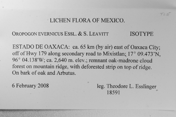
"dwc:verbatimCoordinates": "17° 09.473' N 96° 04.138' W",
"dwc:recordedBy": "Theodore L. Esslinger",
"dwc:habitat": "remnant oak-madrone cloud forest on mountain ridge, with deforested strip on top of ridge.; On bark of oak and Arbutus.",
"dwc:scientificNameAuthorship": "Essl. & S. Leavitt",
"dwc:occurrenceID": "1564582",
"dwc:dateIdentified": "unknown",
"dwc:verbatimElevation": "ca. 2,640 m.",
"symbiota:recordEnteredBy": "tnash",
"dwc:stateProvince": "Oaxaca",
"dwc:eventDate": "2008-02-06",
"dwc:collectionID": "8f07e9fb-8d26-49c1-8ce4-de648c7e7c0a",
"dwc:country": "Mexico",
"idigbio:recordId": "urn:uuid:203cba50-8737-473f-abb3-6f96b2c82596",
"dwc:typeStatus": "Isotype",
"dwc:decimalLatitude": "17.157883",
"dwc:basisOfRecord": "PreservedSpecimen",
"dc:rights": "http://creativecommons.org/licenses/by-nc/3.0/",
"dwc:identifiedBy": "Theodore L. Esslinger",
"dcterms:references": "http://lichenportal.org/portal/collections/individual/index.php?occid=1564582",
"dwc:locality": "ca. 65 km (by air) east of Oaxaca City; off of Hwy 179 along secondary road to Mixistlan",
"dwc:institutionCode": "TLE",
"dwc:catalogNumber": "0023327",
"dwc:decimalLongitude": "-96.068967",
"dwc:recordNumber": "18591",
"dwc:minimumElevationInMeters": "2640",
"dcterms:modified": "2015-07-13 14:30:33",
"dwc:scientificName": "Oropogon evernicus"
},
"indexTerms": {
"recordset": "dfd53a42-8f63-4040-93a5-3f1347ce7686",
"dqs": 0.2608695652173913,
"stateprovince": "oaxaca",
"catalognumber": "0023327",
"startdayofyear": 37,
"collector": "theodore l. esslinger",
"continent": "north america",
"uuid": "da2a6eec-4794-4e77-9bf4-8b9783b0f8b6",
"countrycode": "mex",
"basisofrecord": "preservedspecimen",
"institutioncode": "tle",
"mediarecords": [
"eb39a3c8-c54c-4698-9e69-7a71fe82d8b2"
],
"datecollected": "2008-02-06T00:00:00+00:00",
"etag": "ca716cfe68ea773d462c8c91e7b6f1fbcd35765a",
"typestatus": "isotype",
"recordnumber": "18591",
"minelevation": 2640,
"hasImage": true,
"collectionid": "8f07e9fb-8d26-49c1-8ce4-de648c7e7c0a",
"scientificname": "oropogon evernicus",
"locality": "ca. 65 km (by air) east of oaxaca city; off of hwy 179 along secondary road to mixistlan",
"hasMedia": true,
"datemodified": "2015-09-30T14:33:12.072129+00:00",
"occurrenceid": "1564582",
"country": "mexico",
"geopoint": {
"lat": 17.157883,
"lon": -96.068967
},
"flags": [
"geopoint_datum_missing",
"idigbio_isocountrycode_added",
"dwc_continent_added"
],
"recordids": [
"urn:uuid:203cba50-8737-473f-abb3-6f96b2c82596",
"dfd53a42-8f63-4040-93a5-3f1347ce7686\\1564582"
],
"eventdate": "2008-02-06",
"indexData": {
"dwc:verbatimCoordinates": "17° 09.473' N 96° 04.138' W",
"dwc:recordedBy": "Theodore L. Esslinger",
"idigbio:uuid": "da2a6eec-4794-4e77-9bf4-8b9783b0f8b6",
"dcterms:references": "http://lichenportal.org/portal/collections/individual/index.php?occid=1564582",
"dwc:scientificNameAuthorship": "Essl. & S. Leavitt",
"idigbio:recordIds": [
"urn:uuid:203cba50-8737-473f-abb3-6f96b2c82596",
"dfd53a42-8f63-4040-93a5-3f1347ce7686\\1564582"
],
"dwc:occurrenceID": "1564582",
"dwc:dateIdentified": "unknown",
"idigbio:etag": "ca716cfe68ea773d462c8c91e7b6f1fbcd35765a",
"dwc:verbatimElevation": "ca. 2,640 m.",
"symbiota:recordEnteredBy": "tnash",
"idigbio:parent": "dfd53a42-8f63-4040-93a5-3f1347ce7686",
"dwc:stateProvince": "Oaxaca",
"dwc:eventDate": "2008-02-06",
"dwc:collectionID": "8f07e9fb-8d26-49c1-8ce4-de648c7e7c0a",
"dwc:country": "Mexico",
"idigbio:recordId": "urn:uuid:203cba50-8737-473f-abb3-6f96b2c82596",
"dwc:typeStatus": "Isotype",
"dwc:decimalLatitude": "17.157883",
"dwc:basisOfRecord": "PreservedSpecimen",
"dwc:continent": "north america",
"dc:rights": "http://creativecommons.org/licenses/by-nc/3.0/",
"dwc:identifiedBy": "Theodore L. Esslinger",
"idigbio:siblings": {
"mediarecord": [
"eb39a3c8-c54c-4698-9e69-7a71fe82d8b2"
]
},
"flag_idigbio_isocountrycode_added": true,
"dwc:habitat": "remnant oak-madrone cloud forest on mountain ridge, with deforested strip on top of ridge.; On bark of oak and Arbutus.",
"idigbio:dateModified": "2015-09-30T14:33:12.072129",
"dwc:locality": "ca. 65 km (by air) east of Oaxaca City; off of Hwy 179 along secondary road to Mixistlan",
"dwc:institutionCode": "TLE",
"dwc:catalogNumber": "0023327",
"dwc:decimalLongitude": "-96.068967",
"flag_dwc_continent_added": true,
"dwc:recordNumber": "18591",
"idigbio:isocountrycode": "mex",
"dwc:minimumElevationInMeters": "2640",
"dcterms:modified": "2015-07-13 14:30:33",
"dwc:scientificName": "Oropogon evernicus"
}
},
"attribution": {
"uuid": "dfd53a42-8f63-4040-93a5-3f1347ce7686",
"name": "T. L. Esslinger Herbarium",
"description": "T. L. Esslinger's private collection.",
"logo": "http://lichenportal.org/portal/images/collicons/TLE.jpg",
"url": "http://www.ndsu.edu/pubweb/~esslinge/chcklst/chcklst7.htm",
"emllink": "http://lichenportal.org/portal/collections/datasets/dwc/tle_dwc-a.eml",
"archivelink": "http://lichenportal.org/portal/collections/datasets/dwc/tle_dwc-a.zip",
"contacts": [
{
"email": "CNALHadmin@asu.edu"
},
{
"first_name": "T. L. Esslinger",
"email": "ted.esslinger@ndsu.edu"
}
],
"data_rights": "CC3 BY-NC",
"publisher": "efd00b2c-5ade-4a90-a95a-3f9188fcfa71",
"totalCount": 26072
}
}
 T. L. Esslinger's private collection.