{
"uuid": "acd0e2e5-3d44-4b48-9b0f-11f5318b27a0",
"type": "records",
"etag": "e740bec13e743c1404970b5903ecf7defb3c858a",
"data": {
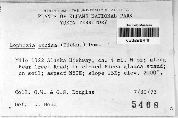
"dwc:startDayOfYear": "211",
"dwc:verbatimCoordinates": "aspect N80E",
"dwc:recordedBy": "G. W. Douglas",
"dwc:georeferenceSources": "georef batch tool 2015-04-09; GeoLocate",
"dcterms:references": "http://bryophyteportal.org/portal/collections/individual/index.php?occid=2772941",
"dwc:occurrenceID": "2772941",
"dwc:verbatimElevation": "2000 ft.",
"symbiota:recordEnteredBy": "ranglin",
"dwc:stateProvince": "Yukon Territory",
"dwc:eventDate": "1973-07-30",
"dwc:collectionID": "55d204bf-cd63-4f46-af8b-dde8b8112271",
"dwc:country": "Canada",
"idigbio:recordId": "urn:uuid:e1619f48-bcbb-481e-9ffb-f9320707d242",
"dwc:decimalLatitude": "60.797211",
"dwc:occurrenceRemarks": "slope 15%",
"dwc:basisOfRecord": "PreservedSpecimen",
"dc:rights": "http://creativecommons.org/licenses/by-nc/3.0/",
"dwc:habitat": "in closed Picea glauca stand; on soil",
"dwc:locality": "Mile 1022 Alaska Highway, ca. 4 mi W of; along Bear Creek Road",
"dwc:institutionCode": "SIU",
"dwc:georeferenceVerificationStatus": "reviewed - high confidence",
"dwc:catalogNumber": "C1022049F",
"dwc:month": "7",
"dwc:decimalLongitude": "-137.672819",
"dwc:georeferencedBy": "ssmigielski92 (2015-04-09 07:06:54)",
"dwc:verbatimEventDate": "7/30/73",
"dwc:minimumElevationInMeters": "610",
"dcterms:modified": "2015-07-15 13:09:45",
"dwc:coordinateUncertaintyInMeters": "200",
"dwc:day": "30",
"dwc:year": "1973"
},
"indexTerms": {
"recordset": "f630e3ea-697f-404a-8683-b86712c26c43",
"dqs": 0.2463768115942029,
"stateprovince": "yukon territory",
"catalognumber": "c1022049f",
"startdayofyear": 211,
"collector": "g. w. douglas",
"continent": "north america",
"uuid": "acd0e2e5-3d44-4b48-9b0f-11f5318b27a0",
"countrycode": "can",
"basisofrecord": "preservedspecimen",
"institutioncode": "siu",
"mediarecords": [
"5253d90d-5544-45d7-8739-5326389d2827"
],
"datecollected": "1973-07-30T00:00:00+00:00",
"etag": "e740bec13e743c1404970b5903ecf7defb3c858a",
"hasMedia": true,
"minelevation": 610,
"hasImage": true,
"collectionid": "55d204bf-cd63-4f46-af8b-dde8b8112271",
"locality": "mile 1022 alaska highway, ca. 4 mi w of; along bear creek road",
"coordinateuncertainty": 200,
"datemodified": "2015-09-30T14:00:49.392325+00:00",
"occurrenceid": "2772941",
"country": "canada",
"geopoint": {
"lat": 60.797211,
"lon": -137.672819
},
"flags": [
"geopoint_datum_missing",
"idigbio_isocountrycode_added",
"dwc_continent_added"
],
"verbatimeventdate": "7/30/73",
"recordids": [
"urn:uuid:e1619f48-bcbb-481e-9ffb-f9320707d242",
"f630e3ea-697f-404a-8683-b86712c26c43\\2772941"
],
"eventdate": "1973-07-30",
"indexData": {
"dwc:startDayOfYear": "211",
"dwc:verbatimCoordinates": "aspect N80E",
"dwc:recordedBy": "G. W. Douglas",
"idigbio:uuid": "acd0e2e5-3d44-4b48-9b0f-11f5318b27a0",
"dwc:locality": "Mile 1022 Alaska Highway, ca. 4 mi W of; along Bear Creek Road",
"dwc:habitat": "in closed Picea glauca stand; on soil",
"idigbio:recordIds": [
"urn:uuid:e1619f48-bcbb-481e-9ffb-f9320707d242",
"f630e3ea-697f-404a-8683-b86712c26c43\\2772941"
],
"dwc:occurrenceID": "2772941",
"dwc:verbatimElevation": "2000 ft.",
"symbiota:recordEnteredBy": "ranglin",
"idigbio:parent": "f630e3ea-697f-404a-8683-b86712c26c43",
"dwc:stateProvince": "Yukon Territory",
"dwc:eventDate": "1973-07-30",
"dwc:collectionID": "55d204bf-cd63-4f46-af8b-dde8b8112271",
"dwc:country": "Canada",
"idigbio:recordId": "urn:uuid:e1619f48-bcbb-481e-9ffb-f9320707d242",
"idigbio:etag": "e740bec13e743c1404970b5903ecf7defb3c858a",
"dwc:decimalLatitude": "60.797211",
"dwc:occurrenceRemarks": "slope 15%",
"dwc:basisOfRecord": "PreservedSpecimen",
"dwc:continent": "north america",
"dc:rights": "http://creativecommons.org/licenses/by-nc/3.0/",
"idigbio:siblings": {
"mediarecord": [
"5253d90d-5544-45d7-8739-5326389d2827"
]
},
"flag_idigbio_isocountrycode_added": true,
"dcterms:references": "http://bryophyteportal.org/portal/collections/individual/index.php?occid=2772941",
"idigbio:dateModified": "2015-09-30T14:00:49.392325",
"dwc:georeferenceSources": "georef batch tool 2015-04-09; GeoLocate",
"dwc:institutionCode": "SIU",
"dwc:georeferenceVerificationStatus": "reviewed - high confidence",
"dwc:catalogNumber": "C1022049F",
"dwc:month": "7",
"dwc:decimalLongitude": "-137.672819",
"dwc:georeferencedBy": "ssmigielski92 (2015-04-09 07:06:54)",
"dwc:verbatimEventDate": "7/30/73",
"flag_dwc_continent_added": true,
"idigbio:isocountrycode": "can",
"dwc:minimumElevationInMeters": "610",
"dcterms:modified": "2015-07-15 13:09:45",
"dwc:coordinateUncertaintyInMeters": "200",
"dwc:day": "30",
"dwc:year": "1973"
}
},
"attribution": {
"uuid": "f630e3ea-697f-404a-8683-b86712c26c43",
"name": "Southern Illinois University Herbarium",
"description": "The SIU herbarium originated in 1878 and currently contains over 250,000 specimens. It is located in room 424 in the Life Science 2 building on the Carbondale campus of Southern Illinois University. Although collections are worldwide (esp. Australia), the majority are from the United States and Illinois, western Kentucky, and southeast Missouri.",
"logo": "http://bryophyteportal.org/portal/images/collicons/siu.jpg",
"url": "http://plantbiology.siu.edu/facilities/plant-biology-facilities/SIU-herbarium.php",
"emllink": "http://bryophyteportal.org/portal/collections/datasets/dwc/siu_dwc-a.eml",
"archivelink": "http://bryophyteportal.org/portal/collections/datasets/dwc/siu_dwc-a.zip",
"contacts": [
{
"email": "egbot@asu.edu"
},
{
"first_name": "Dr. Nancy Garwood, Curator",
"email": "ngarwood@plant.siu.edu"
}
],
"data_rights": "CC3 BY-NC",
"publisher": "4e1beef9-d7c0-4ac0-87df-065bc5a55361",
"totalCount": 19105
}
}
 The SIU herbarium originated in 1878 and currently contains over 250,000 specimens. It is located in room 424 in the Life Science 2 building on the Carbondale campus of Southern Illinois University. Although collections are worldwide (esp. Australia), the majority are from the United States and Illinois, western Kentucky, and southeast Missouri.