{
"uuid": "8e7bb8f5-9fd7-4ed7-9838-d00c01eccea7",
"type": "records",
"etag": "97833af11a3bc07ffea54cbc85054cb5816612fd",
"data": {
"dwc:specificEpithet": "susa",
"dwc:county": "Stone",
"dwc:recordedBy": "Gerould Wilhelm; Douglas Ladd",
"dwc:georeferenceSources": "2016-01-14; Robert Anglin script for Township Range Section in GeoLocate",
"dwc:order": "Arthoniales",
"dwc:habitat": "on Acer saccharum",
"dwc:scientificNameAuthorship": "R.C. Harris & Lendemer",
"dwc:occurrenceID": "7758b33b-9e78-4309-93b4-19030f0bcddb",
"dwc:dateIdentified": "August 2020",
"dwc:verbatimCoordinates": "TRS: T26N R23W SW NE Sec. 19",
"id": "1415865",
"dwc:taxonID": "256882",
"dwc:stateProvince": "Missouri",
"dwc:eventDate": "1987-10-18",
"symbiota:recordEnteredBy": "kelueders",
"dwc:collectionID": "36ea544b-df08-4f21-80e5-dd1c0bdc39c6",
"dwc:country": "U.S.A.",
"dwc:georeferenceRemarks": "lat/long = TRS; uncertainty = extent of Section",
"dwc:higherClassification": "Fungi|Dikarya|Ascomycota|Pezizomycotina|Arthoniomycetes|Arthoniomycetidae|Arthoniales|Arthoniaceae|Arthonia",
"dwc:kingdom": "Fungi",
"dwc:decimalLatitude": "36.892809",
"dwc:basisOfRecord": "PreservedSpecimen",
"dwc:genus": "Arthonia",
"dwc:family": "Arthoniaceae",
"dc:rights": "http://creativecommons.org/licenses/by-nc/3.0/",
"dwc:identifiedBy": "Gerould Wilhelm",
"symbiota:recordID": "7758b33b-9e78-4309-93b4-19030f0bcddb",
"dwc:phylum": "Ascomycota",
"dcterms:references": "https://lichenportal.org/cnalh/collections/individual/index.php?occid=1415865",
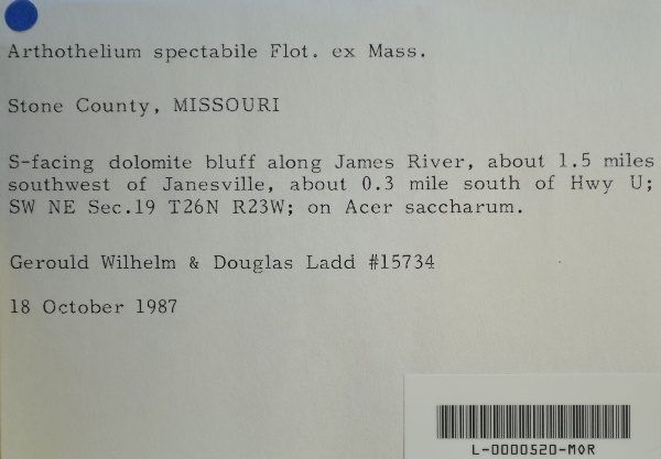
"dwc:locality": "S-facing dolomite bluff along James River, about 1.5 miles southwest of Janesville, about 0.3 mile south of Hwy U.",
"dwc:institutionCode": "MOR",
"dwc:taxonRank": "Species",
"dwc:class": "Arthoniomycetes",
"dwc:catalogNumber": "L-0000520-MOR",
"dwc:decimalLongitude": "-93.421839",
"dwc:coordinateUncertaintyInMeters": "1100",
"dwc:otherCatalogNumbers": "000203",
"dwc:georeferencedBy": "ranglin",
"dwc:verbatimEventDate": "18 October 1987",
"dwc:recordNumber": "15734",
"dcterms:modified": "2022-08-25 09:03:42",
"dwc:scientificName": "Arthonia susa"
},
"indexTerms": {
"geopoint": {
"lat": 36.892809,
"lon": -93.421839
},
"family": "arthoniaceae",
"recordset": "99b04c9f-908e-42bd-92bc-41aa94b72949",
"dqs": 0.391304347826087,
"stateprovince": "missouri",
"county": "stone",
"phylum": "ascomycota",
"catalognumber": "l-0000520-mor",
"startdayofyear": 291,
"taxonrank": "species",
"specificepithet": "susa",
"continent": "north america",
"uuid": "8e7bb8f5-9fd7-4ed7-9838-d00c01eccea7",
"countrycode": "usa",
"basisofrecord": "preservedspecimen",
"collector": "gerould wilhelm; douglas ladd",
"institutioncode": "mor",
"mediarecords": [
"8204f3d9-766d-4d81-816a-a11539952fbf",
"1c043ff4-ae07-4941-878b-b52f563b9bd1"
],
"datemodified": "2023-01-11T04:06:24.025307+00:00",
"datecollected": "1987-10-18T00:00:00+00:00",
"etag": "97833af11a3bc07ffea54cbc85054cb5816612fd",
"recordnumber": "15734",
"hasImage": true,
"kingdom": "fungi",
"highertaxon": "fungi|dikarya|ascomycota|pezizomycotina|arthoniomycetes|arthoniomycetidae|arthoniales|arthoniaceae|arthonia",
"collectionid": "36ea544b-df08-4f21-80e5-dd1c0bdc39c6",
"taxonid": "256882",
"scientificname": "arthonia susa",
"indexData": {
"flag_dwc_country_replaced": true,
"dwc:specificEpithet": "susa",
"dwc:county": "Stone",
"dwc:recordedBy": "Gerould Wilhelm; Douglas Ladd",
"idigbio:uuid": "8e7bb8f5-9fd7-4ed7-9838-d00c01eccea7",
"dwc:locality": "S-facing dolomite bluff along James River, about 1.5 miles southwest of Janesville, about 0.3 mile south of Hwy U.",
"dwc:order": "Arthoniales",
"dwc:habitat": "on Acer saccharum",
"dwc:scientificNameAuthorship": "R.C. Harris & Lendemer",
"idigbio:recordIds": [
"urn:uuid:7758b33b-9e78-4309-93b4-19030f0bcddb",
"99b04c9f-908e-42bd-92bc-41aa94b72949\\1415865",
"99b04c9f-908e-42bd-92bc-41aa94b72949\\7758b33b-9e78-4309-93b4-19030f0bcddb"
],
"dwc:occurrenceID": "7758b33b-9e78-4309-93b4-19030f0bcddb",
"dwc:dateIdentified": "August 2020",
"dwc:verbatimCoordinates": "TRS: T26N R23W SW NE Sec. 19",
"symbiota:recordEnteredBy": "kelueders",
"dwc:taxonID": "256882",
"idigbio:parent": "99b04c9f-908e-42bd-92bc-41aa94b72949",
"dwc:stateProvince": "Missouri",
"dwc:eventDate": "1987-10-18",
"dwc:collectionID": "36ea544b-df08-4f21-80e5-dd1c0bdc39c6",
"dwc:country": "united states",
"idigbio:etag": "97833af11a3bc07ffea54cbc85054cb5816612fd",
"dwc:decimalLatitude": "36.892809",
"id": "1415865",
"dwc:kingdom": "Fungi",
"dwc:georeferenceRemarks": "lat/long = TRS; uncertainty = extent of Section",
"dwc:basisOfRecord": "PreservedSpecimen",
"dwc:genus": "Arthonia",
"dwc:continent": "north america",
"dwc:family": "Arthoniaceae",
"dc:rights": "http://creativecommons.org/licenses/by-nc/3.0/",
"dwc:identifiedBy": "Gerould Wilhelm",
"dwc:class": "Arthoniomycetes",
"idigbio:siblings": {
"mediarecord": [
"8204f3d9-766d-4d81-816a-a11539952fbf",
"1c043ff4-ae07-4941-878b-b52f563b9bd1"
]
},
"symbiota:recordID": "7758b33b-9e78-4309-93b4-19030f0bcddb",
"flag_idigbio_isocountrycode_added": true,
"dwc:phylum": "Ascomycota",
"dcterms:references": "https://lichenportal.org/cnalh/collections/individual/index.php?occid=1415865",
"idigbio:dateModified": "2023-01-11T04:06:24.025307",
"dwc:georeferenceSources": "2016-01-14; Robert Anglin script for Township Range Section in GeoLocate",
"dwc:institutionCode": "MOR",
"dwc:taxonRank": "Species",
"dwc:higherClassification": "Fungi|Dikarya|Ascomycota|Pezizomycotina|Arthoniomycetes|Arthoniomycetidae|Arthoniales|Arthoniaceae|Arthonia",
"dwc:catalogNumber": "L-0000520-MOR",
"dwc:decimalLongitude": "-93.421839",
"dwc:scientificName": "Arthonia susa",
"dwc:otherCatalogNumbers": "000203",
"dwc:georeferencedBy": "ranglin",
"dwc:verbatimEventDate": "18 October 1987",
"flag_dwc_continent_added": true,
"dwc:recordNumber": "15734",
"idigbio:isocountrycode": "usa",
"flag_taxon_match_failed": true,
"dcterms:modified": "2022-08-25 09:03:42",
"dwc:coordinateUncertaintyInMeters": "1100"
},
"hasMedia": true,
"coordinateuncertainty": 1100,
"class": "arthoniomycetes",
"occurrenceid": "7758b33b-9e78-4309-93b4-19030f0bcddb",
"country": "united states",
"locality": "s-facing dolomite bluff along james river, about 1.5 miles southwest of janesville, about 0.3 mile south of hwy u.",
"eventdate": "1987-10-18",
"flags": [
"geopoint_datum_missing",
"dwc_country_replaced",
"idigbio_isocountrycode_added",
"dwc_continent_added",
"taxon_match_failed"
],
"verbatimeventdate": "18 october 1987",
"recordids": [
"urn:uuid:7758b33b-9e78-4309-93b4-19030f0bcddb",
"99b04c9f-908e-42bd-92bc-41aa94b72949\\1415865",
"99b04c9f-908e-42bd-92bc-41aa94b72949\\7758b33b-9e78-4309-93b4-19030f0bcddb"
],
"genus": "arthonia",
"order": "arthoniales"
},
"attribution": {
"uuid": "99b04c9f-908e-42bd-92bc-41aa94b72949",
"name": "Morton Arboretum",
"description": "The Morton Arboretum is an internationally recognized nonprofit organization dedicated to the planting and conservation of trees. Its 1,700 acres hold more than 222,000 live plants representing nearly 4,300 taxa from around the world.",
"logo": "https://lichenportal.org/cnalh/content/collicon/maple_tree_fall.jpg",
"url": "http://www.mortonarb.org/",
"emllink": "https://lichenportal.org/cnalh/content/dwca/mor_dwc-a.eml",
"archivelink": "https://lichenportal.org/cnalh/content/dwca/mor_dwc-a.zip",
"contacts": [
{
"email": "CNALH.help@gmail.com"
},
{
"email": "CNALH.help@gmail.com"
},
{
"email": "Ahipp@mortonarb.org"
},
{
"first_name": null,
"last_name": "Andrew Hipp",
"email": "Ahipp@mortonarb.org"
},
{
"first_name": null,
"last_name": "Andrew Hipp",
"email": "Ahipp@mortonarb.org"
}
],
"data_rights": "CC3 BY-NC",
"publisher": "efd00b2c-5ade-4a90-a95a-3f9188fcfa71",
"totalCount": 17915
}
}

 The Morton Arboretum is an internationally recognized nonprofit organization dedicated to the planting and conservation of trees. Its 1,700 acres hold more than 222,000 live plants representing nearly 4,300 taxa from around the world.