{
"uuid": "7879d24f-8a83-49ec-a0ab-1201db6600ca",
"type": "records",
"etag": "ca248fe33a935562e12f5428c95e5ee1f3d63101",
"data": {
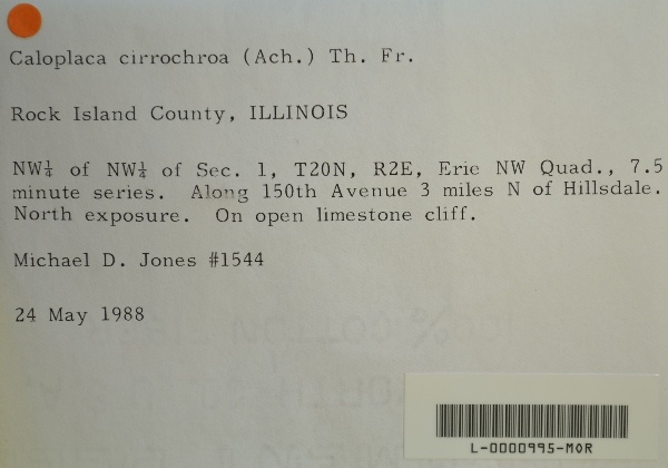
"dwc:verbatimCoordinates": "TRS: T20N R2E NW 1/4 NW 1/4 Sec. 1",
"dwc:county": "Rock Island",
"dwc:recordedBy": "Michael D. Jones",
"dwc:georeferenceSources": "GeoLocate",
"dcterms:references": "https://lichenportal.org/cnalh/collections/individual/index.php?occid=1416339",
"dwc:occurrenceID": "2b299d35-246e-446d-88c7-d4d2f7b1b0db",
"dwc:geodeticDatum": "WGS84",
"symbiota:recordEnteredBy": "kelueders",
"dwc:stateProvince": "Illinois",
"dwc:eventDate": "1988-05-24",
"dwc:collectionID": "36ea544b-df08-4f21-80e5-dd1c0bdc39c6",
"dwc:country": "U.S.A.",
"dwc:georeferenceRemarks": "Quad Map: Erie NW; collector's description",
"id": "1416339",
"dwc:decimalLatitude": "41.664744",
"dwc:basisOfRecord": "PreservedSpecimen",
"dc:rights": "http://creativecommons.org/licenses/by-nc/3.0/",
"symbiota:recordID": "2b299d35-246e-446d-88c7-d4d2f7b1b0db",
"dwc:habitat": "on open limestone cliff, north exposure",
"dwc:locality": "Erie NW Quad., 7.5 minute series. Along 150th Avenue 3 miles N of Hillsdale.",
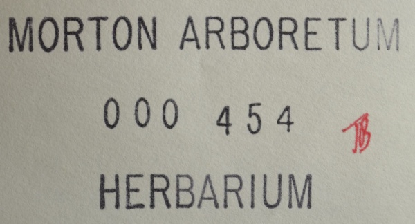
"dwc:institutionCode": "MOR",
"dwc:catalogNumber": "L-0000995-MOR",
"dwc:decimalLongitude": "-90.210151",
"dwc:coordinateUncertaintyInMeters": "2152",
"dwc:otherCatalogNumbers": "000454",
"dwc:georeferencedBy": "kelueders",
"dwc:recordNumber": "1544",
"dcterms:modified": "2016-04-19 21:35:32",
"dwc:scientificName": "Caloplaca cirrhochroa"
},
"indexTerms": {
"recordset": "99b04c9f-908e-42bd-92bc-41aa94b72949",
"dqs": 0.2608695652173913,
"stateprovince": "illinois",
"county": "rock island",
"catalognumber": "l-0000995-mor",
"startdayofyear": 145,
"collector": "michael d. jones",
"continent": "north america",
"uuid": "7879d24f-8a83-49ec-a0ab-1201db6600ca",
"countrycode": "usa",
"basisofrecord": "preservedspecimen",
"institutioncode": "mor",
"mediarecords": [
"00c68f43-17c3-45d8-b37a-b61c26dfda30",
"548f6ea1-ee07-4665-b2b7-26f7738af48b"
],
"datecollected": "1988-05-24T00:00:00+00:00",
"etag": "ca248fe33a935562e12f5428c95e5ee1f3d63101",
"recordnumber": "1544",
"hasImage": true,
"collectionid": "36ea544b-df08-4f21-80e5-dd1c0bdc39c6",
"scientificname": "caloplaca cirrhochroa",
"locality": "erie nw quad., 7.5 minute series. along 150th avenue 3 miles n of hillsdale.",
"hasMedia": true,
"coordinateuncertainty": 2152,
"datemodified": "2023-01-11T04:06:24.025307+00:00",
"occurrenceid": "2b299d35-246e-446d-88c7-d4d2f7b1b0db",
"country": "united states",
"geopoint": {
"lat": 41.664744,
"lon": -90.210151
},
"flags": [
"dwc_country_replaced",
"idigbio_isocountrycode_added",
"dwc_continent_added"
],
"recordids": [
"urn:uuid:2b299d35-246e-446d-88c7-d4d2f7b1b0db",
"99b04c9f-908e-42bd-92bc-41aa94b72949\\1416339",
"99b04c9f-908e-42bd-92bc-41aa94b72949\\2b299d35-246e-446d-88c7-d4d2f7b1b0db"
],
"eventdate": "1988-05-24",
"indexData": {
"dwc:verbatimCoordinates": "TRS: T20N R2E NW 1/4 NW 1/4 Sec. 1",
"dwc:county": "Rock Island",
"dwc:recordedBy": "Michael D. Jones",
"idigbio:uuid": "7879d24f-8a83-49ec-a0ab-1201db6600ca",
"dwc:locality": "Erie NW Quad., 7.5 minute series. Along 150th Avenue 3 miles N of Hillsdale.",
"dcterms:references": "https://lichenportal.org/cnalh/collections/individual/index.php?occid=1416339",
"idigbio:recordIds": [
"urn:uuid:2b299d35-246e-446d-88c7-d4d2f7b1b0db",
"99b04c9f-908e-42bd-92bc-41aa94b72949\\1416339",
"99b04c9f-908e-42bd-92bc-41aa94b72949\\2b299d35-246e-446d-88c7-d4d2f7b1b0db"
],
"dwc:occurrenceID": "2b299d35-246e-446d-88c7-d4d2f7b1b0db",
"id": "1416339",
"idigbio:parent": "99b04c9f-908e-42bd-92bc-41aa94b72949",
"dwc:stateProvince": "Illinois",
"dwc:eventDate": "1988-05-24",
"dwc:collectionID": "36ea544b-df08-4f21-80e5-dd1c0bdc39c6",
"dwc:country": "united states",
"idigbio:etag": "ca248fe33a935562e12f5428c95e5ee1f3d63101",
"dwc:georeferenceRemarks": "Quad Map: Erie NW; collector's description",
"symbiota:recordEnteredBy": "kelueders",
"dwc:decimalLatitude": "41.664744",
"dwc:basisOfRecord": "PreservedSpecimen",
"dwc:continent": "north america",
"dc:rights": "http://creativecommons.org/licenses/by-nc/3.0/",
"flag_dwc_country_replaced": true,
"dwc:geodeticDatum": "WGS84",
"idigbio:siblings": {
"mediarecord": [
"00c68f43-17c3-45d8-b37a-b61c26dfda30",
"548f6ea1-ee07-4665-b2b7-26f7738af48b"
]
},
"symbiota:recordID": "2b299d35-246e-446d-88c7-d4d2f7b1b0db",
"flag_idigbio_isocountrycode_added": true,
"dwc:habitat": "on open limestone cliff, north exposure",
"idigbio:dateModified": "2023-01-11T04:06:24.025307",
"dwc:georeferenceSources": "GeoLocate",
"dwc:institutionCode": "MOR",
"dwc:catalogNumber": "L-0000995-MOR",
"dwc:decimalLongitude": "-90.210151",
"dwc:scientificName": "Caloplaca cirrhochroa",
"dwc:otherCatalogNumbers": "000454",
"dwc:georeferencedBy": "kelueders",
"flag_dwc_continent_added": true,
"dwc:recordNumber": "1544",
"idigbio:isocountrycode": "usa",
"dcterms:modified": "2016-04-19 21:35:32",
"dwc:coordinateUncertaintyInMeters": "2152"
}
},
"attribution": {
"uuid": "99b04c9f-908e-42bd-92bc-41aa94b72949",
"name": "Morton Arboretum",
"description": "The Morton Arboretum is an internationally recognized nonprofit organization dedicated to the planting and conservation of trees. Its 1,700 acres hold more than 222,000 live plants representing nearly 4,300 taxa from around the world.",
"logo": "https://lichenportal.org/cnalh/content/collicon/maple_tree_fall.jpg",
"url": "http://www.mortonarb.org/",
"emllink": "https://lichenportal.org/cnalh/content/dwca/mor_dwc-a.eml",
"archivelink": "https://lichenportal.org/cnalh/content/dwca/mor_dwc-a.zip",
"contacts": [
{
"email": "CNALH.help@gmail.com"
},
{
"email": "CNALH.help@gmail.com"
},
{
"email": "Ahipp@mortonarb.org"
},
{
"first_name": null,
"last_name": "Andrew Hipp",
"email": "Ahipp@mortonarb.org"
},
{
"first_name": null,
"last_name": "Andrew Hipp",
"email": "Ahipp@mortonarb.org"
}
],
"data_rights": "CC3 BY-NC",
"publisher": "efd00b2c-5ade-4a90-a95a-3f9188fcfa71",
"totalCount": 17915
}
}
 The Morton Arboretum is an internationally recognized nonprofit organization dedicated to the planting and conservation of trees. Its 1,700 acres hold more than 222,000 live plants representing nearly 4,300 taxa from around the world.