{
"uuid": "64f53b77-26aa-4c59-b0b8-0d28475ccd34",
"type": "records",
"etag": "b6cecf95c2993fdd10871d84ad67b962bd62e17b",
"data": {
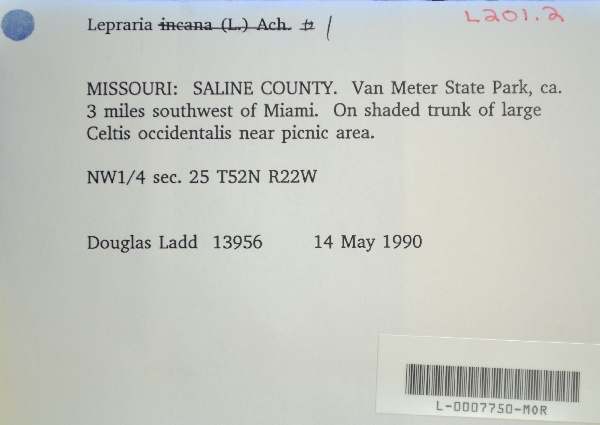
"dwc:verbatimCoordinates": "TRS: T52N R22W NW 1/4 Sec. 25",
"dwc:county": "Saline",
"dwc:recordedBy": "Douglas Ladd",
"dwc:georeferenceSources": "2016-01-14; Robert Anglin script for Township Range Section in GeoLocate",
"dcterms:references": "https://lichenportal.org/cnalh/collections/individual/index.php?occid=1441651",
"dwc:scientificNameAuthorship": "Ach.",
"dwc:occurrenceID": "342ace69-e2de-44c6-ae05-b958d714c004",
"id": "1441651",
"dwc:stateProvince": "Missouri",
"dwc:eventDate": "1990-05-14",
"dwc:collectionID": "36ea544b-df08-4f21-80e5-dd1c0bdc39c6",
"dwc:country": "U.S.A.",
"dwc:georeferenceRemarks": "lat/long = TRS; uncertainty = extent of Section",
"symbiota:recordEnteredBy": "kelueders",
"dwc:decimalLatitude": "39.267391",
"dwc:basisOfRecord": "PreservedSpecimen",
"dc:rights": "http://creativecommons.org/licenses/by-nc/3.0/",
"symbiota:recordID": "342ace69-e2de-44c6-ae05-b958d714c004",
"dwc:habitat": "on shaded trunk of large Celtis occidentalis",
"dwc:locality": "Van Meter State Park, ca. 3 miles southwest of Miami. Near picnic area",
"dwc:institutionCode": "MOR",
"dwc:catalogNumber": "L-0007750-MOR",
"dwc:decimalLongitude": "-93.274829",
"dwc:coordinateUncertaintyInMeters": "1100",
"dwc:otherCatalogNumbers": "12475",
"dwc:georeferencedBy": "ranglin",
"dwc:recordNumber": "13956",
"dcterms:modified": "2018-03-15 11:21:03",
"dwc:scientificName": "Lepraria sp."
},
"indexTerms": {
"recordset": "99b04c9f-908e-42bd-92bc-41aa94b72949",
"dqs": 0.2463768115942029,
"stateprovince": "missouri",
"county": "saline",
"catalognumber": "l-0007750-mor",
"startdayofyear": 134,
"collector": "douglas ladd",
"continent": "north america",
"uuid": "64f53b77-26aa-4c59-b0b8-0d28475ccd34",
"countrycode": "usa",
"basisofrecord": "preservedspecimen",
"institutioncode": "mor",
"mediarecords": [
"aa8f8f2f-e3c9-444d-a88e-3f76032b7eae",
"27ad7fbb-e354-4495-9fa7-15a65962c4c5"
],
"datecollected": "1990-05-14T00:00:00+00:00",
"etag": "b6cecf95c2993fdd10871d84ad67b962bd62e17b",
"recordnumber": "13956",
"hasImage": true,
"collectionid": "36ea544b-df08-4f21-80e5-dd1c0bdc39c6",
"scientificname": "lepraria sp.",
"locality": "van meter state park, ca. 3 miles southwest of miami. near picnic area",
"hasMedia": true,
"coordinateuncertainty": 1100,
"datemodified": "2023-01-11T04:06:24.025307+00:00",
"occurrenceid": "342ace69-e2de-44c6-ae05-b958d714c004",
"country": "united states",
"geopoint": {
"lat": 39.267391,
"lon": -93.274829
},
"flags": [
"geopoint_datum_missing",
"dwc_country_replaced",
"idigbio_isocountrycode_added",
"dwc_continent_added"
],
"recordids": [
"urn:uuid:342ace69-e2de-44c6-ae05-b958d714c004",
"99b04c9f-908e-42bd-92bc-41aa94b72949\\1441651",
"99b04c9f-908e-42bd-92bc-41aa94b72949\\342ace69-e2de-44c6-ae05-b958d714c004"
],
"eventdate": "1990-05-14",
"indexData": {
"dwc:verbatimCoordinates": "TRS: T52N R22W NW 1/4 Sec. 25",
"dwc:county": "Saline",
"dwc:recordedBy": "Douglas Ladd",
"idigbio:uuid": "64f53b77-26aa-4c59-b0b8-0d28475ccd34",
"dwc:locality": "Van Meter State Park, ca. 3 miles southwest of Miami. Near picnic area",
"dcterms:references": "https://lichenportal.org/cnalh/collections/individual/index.php?occid=1441651",
"dwc:scientificNameAuthorship": "Ach.",
"idigbio:recordIds": [
"urn:uuid:342ace69-e2de-44c6-ae05-b958d714c004",
"99b04c9f-908e-42bd-92bc-41aa94b72949\\1441651",
"99b04c9f-908e-42bd-92bc-41aa94b72949\\342ace69-e2de-44c6-ae05-b958d714c004"
],
"dwc:occurrenceID": "342ace69-e2de-44c6-ae05-b958d714c004",
"symbiota:recordEnteredBy": "kelueders",
"idigbio:parent": "99b04c9f-908e-42bd-92bc-41aa94b72949",
"dwc:stateProvince": "Missouri",
"dwc:eventDate": "1990-05-14",
"dwc:collectionID": "36ea544b-df08-4f21-80e5-dd1c0bdc39c6",
"dwc:country": "united states",
"idigbio:etag": "b6cecf95c2993fdd10871d84ad67b962bd62e17b",
"dwc:georeferenceRemarks": "lat/long = TRS; uncertainty = extent of Section",
"id": "1441651",
"dwc:decimalLatitude": "39.267391",
"dwc:basisOfRecord": "PreservedSpecimen",
"dwc:continent": "north america",
"dc:rights": "http://creativecommons.org/licenses/by-nc/3.0/",
"flag_dwc_country_replaced": true,
"idigbio:siblings": {
"mediarecord": [
"aa8f8f2f-e3c9-444d-a88e-3f76032b7eae",
"27ad7fbb-e354-4495-9fa7-15a65962c4c5"
]
},
"symbiota:recordID": "342ace69-e2de-44c6-ae05-b958d714c004",
"flag_idigbio_isocountrycode_added": true,
"dwc:habitat": "on shaded trunk of large Celtis occidentalis",
"idigbio:dateModified": "2023-01-11T04:06:24.025307",
"dwc:georeferenceSources": "2016-01-14; Robert Anglin script for Township Range Section in GeoLocate",
"dwc:institutionCode": "MOR",
"dwc:catalogNumber": "L-0007750-MOR",
"dwc:decimalLongitude": "-93.274829",
"dwc:scientificName": "Lepraria sp.",
"dwc:otherCatalogNumbers": "12475",
"dwc:georeferencedBy": "ranglin",
"flag_dwc_continent_added": true,
"dwc:recordNumber": "13956",
"idigbio:isocountrycode": "usa",
"dcterms:modified": "2018-03-15 11:21:03",
"dwc:coordinateUncertaintyInMeters": "1100"
}
},
"attribution": {
"uuid": "99b04c9f-908e-42bd-92bc-41aa94b72949",
"name": "Morton Arboretum",
"description": "The Morton Arboretum is an internationally recognized nonprofit organization dedicated to the planting and conservation of trees. Its 1,700 acres hold more than 222,000 live plants representing nearly 4,300 taxa from around the world.",
"logo": "https://lichenportal.org/cnalh/content/collicon/maple_tree_fall.jpg",
"url": "http://www.mortonarb.org/",
"emllink": "https://lichenportal.org/cnalh/content/dwca/mor_dwc-a.eml",
"archivelink": "https://lichenportal.org/cnalh/content/dwca/mor_dwc-a.zip",
"contacts": [
{
"email": "CNALH.help@gmail.com"
},
{
"email": "CNALH.help@gmail.com"
},
{
"email": "Ahipp@mortonarb.org"
},
{
"first_name": null,
"last_name": "Andrew Hipp",
"email": "Ahipp@mortonarb.org"
},
{
"first_name": null,
"last_name": "Andrew Hipp",
"email": "Ahipp@mortonarb.org"
}
],
"data_rights": "CC3 BY-NC",
"publisher": "efd00b2c-5ade-4a90-a95a-3f9188fcfa71",
"totalCount": 17915
}
}
 The Morton Arboretum is an internationally recognized nonprofit organization dedicated to the planting and conservation of trees. Its 1,700 acres hold more than 222,000 live plants representing nearly 4,300 taxa from around the world.