{
"uuid": "4d9c6bf7-47dd-44a1-b8e0-7a6557becdfe",
"type": "records",
"etag": "685719f0ab72a3c8886e6949c7d3aec3be2b7f9e",
"data": {
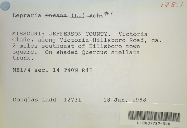
"dwc:verbatimCoordinates": "TRS: T40N R4E NE 1/4 Sec. 14",
"dwc:county": "Jefferson",
"dwc:recordedBy": "Douglas Ladd",
"dwc:georeferenceSources": "2016-01-14; Robert Anglin script for Township Range Section in GeoLocate",
"dcterms:references": "https://lichenportal.org/cnalh/collections/individual/index.php?occid=1441638",
"dwc:scientificNameAuthorship": "Ach.",
"dwc:occurrenceID": "f53f7938-9d03-41a2-8be6-e1899680cf9d",
"id": "1441638",
"dwc:stateProvince": "Missouri",
"dwc:eventDate": "1988-01-18",
"dwc:collectionID": "36ea544b-df08-4f21-80e5-dd1c0bdc39c6",
"dwc:country": "U.S.A.",
"dwc:georeferenceRemarks": "lat/long = TRS; uncertainty = extent of Section",
"symbiota:recordEnteredBy": "kelueders",
"dwc:decimalLatitude": "38.19831",
"dwc:basisOfRecord": "PreservedSpecimen",
"dc:rights": "http://creativecommons.org/licenses/by-nc/3.0/",
"symbiota:recordID": "f53f7938-9d03-41a2-8be6-e1899680cf9d",
"dwc:habitat": "on shaded Quercus stellata trunk",
"dwc:locality": "Victoria Glade, along Victoria-Hillsboro Road, ca. 2 miles southeast of Hillsboro town square.",
"dwc:institutionCode": "MOR",
"dwc:catalogNumber": "L-0007737-MOR",
"dwc:decimalLongitude": "-90.54654",
"dwc:coordinateUncertaintyInMeters": "1100",
"dwc:otherCatalogNumbers": "12466",
"dwc:georeferencedBy": "ranglin",
"dwc:recordNumber": "12731",
"dcterms:modified": "2018-03-15 11:21:03",
"dwc:scientificName": "Lepraria sp."
},
"indexTerms": {
"recordset": "99b04c9f-908e-42bd-92bc-41aa94b72949",
"dqs": 0.2463768115942029,
"stateprovince": "missouri",
"county": "jefferson",
"catalognumber": "l-0007737-mor",
"startdayofyear": 18,
"collector": "douglas ladd",
"continent": "north america",
"uuid": "4d9c6bf7-47dd-44a1-b8e0-7a6557becdfe",
"countrycode": "usa",
"basisofrecord": "preservedspecimen",
"institutioncode": "mor",
"mediarecords": [
"a0eae5c6-3ba2-4435-a37b-837eafe0be71",
"bab92166-1510-41ee-9f63-6f5e262b43ba"
],
"datecollected": "1988-01-18T00:00:00+00:00",
"etag": "685719f0ab72a3c8886e6949c7d3aec3be2b7f9e",
"recordnumber": "12731",
"hasImage": true,
"collectionid": "36ea544b-df08-4f21-80e5-dd1c0bdc39c6",
"scientificname": "lepraria sp.",
"locality": "victoria glade, along victoria-hillsboro road, ca. 2 miles southeast of hillsboro town square.",
"hasMedia": true,
"coordinateuncertainty": 1100,
"datemodified": "2023-01-11T04:06:24.025307+00:00",
"occurrenceid": "f53f7938-9d03-41a2-8be6-e1899680cf9d",
"country": "united states",
"geopoint": {
"lat": 38.19831,
"lon": -90.54654
},
"flags": [
"geopoint_datum_missing",
"dwc_country_replaced",
"idigbio_isocountrycode_added",
"dwc_continent_added"
],
"recordids": [
"urn:uuid:f53f7938-9d03-41a2-8be6-e1899680cf9d",
"99b04c9f-908e-42bd-92bc-41aa94b72949\\1441638",
"99b04c9f-908e-42bd-92bc-41aa94b72949\\f53f7938-9d03-41a2-8be6-e1899680cf9d"
],
"eventdate": "1988-01-18",
"indexData": {
"dwc:verbatimCoordinates": "TRS: T40N R4E NE 1/4 Sec. 14",
"dwc:county": "Jefferson",
"dwc:recordedBy": "Douglas Ladd",
"idigbio:uuid": "4d9c6bf7-47dd-44a1-b8e0-7a6557becdfe",
"dwc:locality": "Victoria Glade, along Victoria-Hillsboro Road, ca. 2 miles southeast of Hillsboro town square.",
"dcterms:references": "https://lichenportal.org/cnalh/collections/individual/index.php?occid=1441638",
"dwc:scientificNameAuthorship": "Ach.",
"idigbio:recordIds": [
"urn:uuid:f53f7938-9d03-41a2-8be6-e1899680cf9d",
"99b04c9f-908e-42bd-92bc-41aa94b72949\\1441638",
"99b04c9f-908e-42bd-92bc-41aa94b72949\\f53f7938-9d03-41a2-8be6-e1899680cf9d"
],
"dwc:occurrenceID": "f53f7938-9d03-41a2-8be6-e1899680cf9d",
"symbiota:recordEnteredBy": "kelueders",
"idigbio:parent": "99b04c9f-908e-42bd-92bc-41aa94b72949",
"dwc:stateProvince": "Missouri",
"dwc:eventDate": "1988-01-18",
"dwc:collectionID": "36ea544b-df08-4f21-80e5-dd1c0bdc39c6",
"dwc:country": "united states",
"idigbio:etag": "685719f0ab72a3c8886e6949c7d3aec3be2b7f9e",
"dwc:georeferenceRemarks": "lat/long = TRS; uncertainty = extent of Section",
"id": "1441638",
"dwc:decimalLatitude": "38.19831",
"dwc:basisOfRecord": "PreservedSpecimen",
"dwc:continent": "north america",
"dc:rights": "http://creativecommons.org/licenses/by-nc/3.0/",
"flag_dwc_country_replaced": true,
"idigbio:siblings": {
"mediarecord": [
"a0eae5c6-3ba2-4435-a37b-837eafe0be71",
"bab92166-1510-41ee-9f63-6f5e262b43ba"
]
},
"symbiota:recordID": "f53f7938-9d03-41a2-8be6-e1899680cf9d",
"flag_idigbio_isocountrycode_added": true,
"dwc:habitat": "on shaded Quercus stellata trunk",
"idigbio:dateModified": "2023-01-11T04:06:24.025307",
"dwc:georeferenceSources": "2016-01-14; Robert Anglin script for Township Range Section in GeoLocate",
"dwc:institutionCode": "MOR",
"dwc:catalogNumber": "L-0007737-MOR",
"dwc:decimalLongitude": "-90.54654",
"dwc:scientificName": "Lepraria sp.",
"dwc:otherCatalogNumbers": "12466",
"dwc:georeferencedBy": "ranglin",
"flag_dwc_continent_added": true,
"dwc:recordNumber": "12731",
"idigbio:isocountrycode": "usa",
"dcterms:modified": "2018-03-15 11:21:03",
"dwc:coordinateUncertaintyInMeters": "1100"
}
},
"attribution": {
"uuid": "99b04c9f-908e-42bd-92bc-41aa94b72949",
"name": "Morton Arboretum",
"description": "The Morton Arboretum is an internationally recognized nonprofit organization dedicated to the planting and conservation of trees. Its 1,700 acres hold more than 222,000 live plants representing nearly 4,300 taxa from around the world.",
"logo": "https://lichenportal.org/cnalh/content/collicon/maple_tree_fall.jpg",
"url": "http://www.mortonarb.org/",
"emllink": "https://lichenportal.org/cnalh/content/dwca/mor_dwc-a.eml",
"archivelink": "https://lichenportal.org/cnalh/content/dwca/mor_dwc-a.zip",
"contacts": [
{
"email": "CNALH.help@gmail.com"
},
{
"email": "CNALH.help@gmail.com"
},
{
"email": "Ahipp@mortonarb.org"
},
{
"first_name": null,
"last_name": "Andrew Hipp",
"email": "Ahipp@mortonarb.org"
},
{
"first_name": null,
"last_name": "Andrew Hipp",
"email": "Ahipp@mortonarb.org"
}
],
"data_rights": "CC3 BY-NC",
"publisher": "efd00b2c-5ade-4a90-a95a-3f9188fcfa71",
"totalCount": 17915
}
}
 The Morton Arboretum is an internationally recognized nonprofit organization dedicated to the planting and conservation of trees. Its 1,700 acres hold more than 222,000 live plants representing nearly 4,300 taxa from around the world.