{
"uuid": "46fbe86c-0e15-4aab-8c4a-a2741f6b6eee",
"type": "records",
"etag": "7bdf0c96bf9a006835a368d9d20a40372a5cd45b",
"data": {
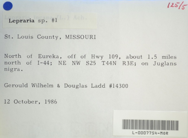
"dwc:verbatimCoordinates": "TRS: T44N R3E NE NW Sec. 25",
"dwc:county": "Saint Louis",
"dwc:recordedBy": "Gerould Wilhelm; Douglas Ladd",
"dwc:georeferenceSources": "2016-01-14; Robert Anglin script for Township Range Section in GeoLocate",
"dcterms:references": "https://lichenportal.org/cnalh/collections/individual/index.php?occid=1441655",
"dwc:scientificNameAuthorship": "Ach.",
"dwc:occurrenceID": "c75c22a2-3870-4062-8dae-4f0ad211b535",
"id": "1441655",
"dwc:stateProvince": "Missouri",
"dwc:eventDate": "1986-10-12",
"dwc:collectionID": "36ea544b-df08-4f21-80e5-dd1c0bdc39c6",
"dwc:country": "U.S.A.",
"dwc:georeferenceRemarks": "lat/long = TRS; uncertainty = extent of Section",
"symbiota:recordEnteredBy": "kelueders",
"dwc:decimalLatitude": "38.524184",
"dwc:basisOfRecord": "PreservedSpecimen",
"dc:rights": "http://creativecommons.org/licenses/by-nc/3.0/",
"symbiota:recordID": "c75c22a2-3870-4062-8dae-4f0ad211b535",
"dwc:habitat": "on Juglans nigra",
"dwc:locality": "North of Eureka, off of Hwy 109, about 1.5 miles north of I-44.",
"dwc:institutionCode": "MOR",
"dwc:catalogNumber": "L-0007754-MOR",
"dwc:decimalLongitude": "-90.633703",
"dwc:coordinateUncertaintyInMeters": "1100",
"dwc:otherCatalogNumbers": "7141",
"dwc:georeferencedBy": "ranglin",
"dwc:recordNumber": "14300",
"dcterms:modified": "2018-03-15 11:21:03",
"dwc:scientificName": "Lepraria sp."
},
"indexTerms": {
"recordset": "99b04c9f-908e-42bd-92bc-41aa94b72949",
"dqs": 0.2463768115942029,
"stateprovince": "missouri",
"county": "saint louis",
"catalognumber": "l-0007754-mor",
"startdayofyear": 285,
"collector": "gerould wilhelm; douglas ladd",
"continent": "north america",
"uuid": "46fbe86c-0e15-4aab-8c4a-a2741f6b6eee",
"countrycode": "usa",
"basisofrecord": "preservedspecimen",
"institutioncode": "mor",
"mediarecords": [
"4a05e89a-0dc0-4c65-87f3-fc3133881c3b",
"11e94da8-3aff-4bfb-aa45-e07ad36a8b6e"
],
"datecollected": "1986-10-12T00:00:00+00:00",
"etag": "7bdf0c96bf9a006835a368d9d20a40372a5cd45b",
"recordnumber": "14300",
"hasImage": true,
"collectionid": "36ea544b-df08-4f21-80e5-dd1c0bdc39c6",
"scientificname": "lepraria sp.",
"locality": "north of eureka, off of hwy 109, about 1.5 miles north of i-44.",
"hasMedia": true,
"coordinateuncertainty": 1100,
"datemodified": "2023-01-11T04:06:24.025307+00:00",
"occurrenceid": "c75c22a2-3870-4062-8dae-4f0ad211b535",
"country": "united states",
"geopoint": {
"lat": 38.524184,
"lon": -90.633703
},
"flags": [
"geopoint_datum_missing",
"dwc_country_replaced",
"idigbio_isocountrycode_added",
"dwc_continent_added"
],
"recordids": [
"urn:uuid:c75c22a2-3870-4062-8dae-4f0ad211b535",
"99b04c9f-908e-42bd-92bc-41aa94b72949\\1441655",
"99b04c9f-908e-42bd-92bc-41aa94b72949\\c75c22a2-3870-4062-8dae-4f0ad211b535"
],
"eventdate": "1986-10-12",
"indexData": {
"dwc:verbatimCoordinates": "TRS: T44N R3E NE NW Sec. 25",
"dwc:county": "Saint Louis",
"dwc:recordedBy": "Gerould Wilhelm; Douglas Ladd",
"idigbio:uuid": "46fbe86c-0e15-4aab-8c4a-a2741f6b6eee",
"dwc:locality": "North of Eureka, off of Hwy 109, about 1.5 miles north of I-44.",
"dcterms:references": "https://lichenportal.org/cnalh/collections/individual/index.php?occid=1441655",
"dwc:scientificNameAuthorship": "Ach.",
"idigbio:recordIds": [
"urn:uuid:c75c22a2-3870-4062-8dae-4f0ad211b535",
"99b04c9f-908e-42bd-92bc-41aa94b72949\\1441655",
"99b04c9f-908e-42bd-92bc-41aa94b72949\\c75c22a2-3870-4062-8dae-4f0ad211b535"
],
"dwc:occurrenceID": "c75c22a2-3870-4062-8dae-4f0ad211b535",
"symbiota:recordEnteredBy": "kelueders",
"idigbio:parent": "99b04c9f-908e-42bd-92bc-41aa94b72949",
"dwc:stateProvince": "Missouri",
"dwc:eventDate": "1986-10-12",
"dwc:collectionID": "36ea544b-df08-4f21-80e5-dd1c0bdc39c6",
"dwc:country": "united states",
"idigbio:etag": "7bdf0c96bf9a006835a368d9d20a40372a5cd45b",
"dwc:georeferenceRemarks": "lat/long = TRS; uncertainty = extent of Section",
"id": "1441655",
"dwc:decimalLatitude": "38.524184",
"dwc:basisOfRecord": "PreservedSpecimen",
"dwc:continent": "north america",
"dc:rights": "http://creativecommons.org/licenses/by-nc/3.0/",
"flag_dwc_country_replaced": true,
"idigbio:siblings": {
"mediarecord": [
"4a05e89a-0dc0-4c65-87f3-fc3133881c3b",
"11e94da8-3aff-4bfb-aa45-e07ad36a8b6e"
]
},
"symbiota:recordID": "c75c22a2-3870-4062-8dae-4f0ad211b535",
"flag_idigbio_isocountrycode_added": true,
"dwc:habitat": "on Juglans nigra",
"idigbio:dateModified": "2023-01-11T04:06:24.025307",
"dwc:georeferenceSources": "2016-01-14; Robert Anglin script for Township Range Section in GeoLocate",
"dwc:institutionCode": "MOR",
"dwc:catalogNumber": "L-0007754-MOR",
"dwc:decimalLongitude": "-90.633703",
"dwc:scientificName": "Lepraria sp.",
"dwc:otherCatalogNumbers": "7141",
"dwc:georeferencedBy": "ranglin",
"flag_dwc_continent_added": true,
"dwc:recordNumber": "14300",
"idigbio:isocountrycode": "usa",
"dcterms:modified": "2018-03-15 11:21:03",
"dwc:coordinateUncertaintyInMeters": "1100"
}
},
"attribution": {
"uuid": "99b04c9f-908e-42bd-92bc-41aa94b72949",
"name": "Morton Arboretum",
"description": "The Morton Arboretum is an internationally recognized nonprofit organization dedicated to the planting and conservation of trees. Its 1,700 acres hold more than 222,000 live plants representing nearly 4,300 taxa from around the world.",
"logo": "https://lichenportal.org/cnalh/content/collicon/maple_tree_fall.jpg",
"url": "http://www.mortonarb.org/",
"emllink": "https://lichenportal.org/cnalh/content/dwca/mor_dwc-a.eml",
"archivelink": "https://lichenportal.org/cnalh/content/dwca/mor_dwc-a.zip",
"contacts": [
{
"email": "CNALH.help@gmail.com"
},
{
"email": "CNALH.help@gmail.com"
},
{
"email": "Ahipp@mortonarb.org"
},
{
"first_name": null,
"last_name": "Andrew Hipp",
"email": "Ahipp@mortonarb.org"
},
{
"first_name": null,
"last_name": "Andrew Hipp",
"email": "Ahipp@mortonarb.org"
}
],
"data_rights": "CC3 BY-NC",
"publisher": "efd00b2c-5ade-4a90-a95a-3f9188fcfa71",
"totalCount": 17915
}
}
 The Morton Arboretum is an internationally recognized nonprofit organization dedicated to the planting and conservation of trees. Its 1,700 acres hold more than 222,000 live plants representing nearly 4,300 taxa from around the world.