{
"uuid": "3c52b303-125f-4f9a-9beb-b4a5b141abd3",
"type": "records",
"etag": "7d0270b85ea0e9e51445aeda461936db83ebb92e",
"data": {
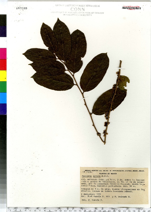
"dwc:specificEpithet": "arguta",
"dwc:countryCode": "MX",
"dwc:county": "Nayarit",
"dwc:recordedBy": "\"Garcia P., Jose\"",
"dwc:georeferenceSources": "2006. Google Earth. © Google Earth.",
"dwc:order": "Violales",
"dwc:occurrenceID": "urn:catalog:UConn:CONN:CONN00120989",
"dwc:verbatimElevation": "90 M",
"dwc:stateProvince": "Mexico",
"dwc:eventDate": "1978-11-09",
"dwc:country": "Mexico",
"dwc:collectionCode": "CONN",
"dwc:verbatimLatitude": "21°57' 7\" N",
"dwc:kingdom": "Dicotyledonae",
"dwc:decimalLatitude": "21.95194",
"dwc:occurrenceRemarks": "Arbusto de 3m. de alto, flores blanquecinas en fasciculos. Escaso en ladera bastante humeda",
"dwc:maximumElevationInMeters": "90",
"dwc:basisOfRecord": "Preserved Specimen",
"dwc:genus": "Casearia",
"dwc:family": "Flacourtiaceae",
"dwc:coordinateUncertaintyInMeters": "5000",
"dwc:municipality": "Ruiz",
"dwc:previousIdentifications": "Casearia arguta Kunth",
"dwc:locationAccordingTo": "seconds added from gazetteer",
"dwc:locality": "Municipio Los Ruiz. 2 Km. sobre la desviacion a Laguna de Pescadores, 31 Km. al SE de Acaponeta, por la carretera Mazatlan-Nayarit. Selva baja caducifolia, bastante perturbada.",
"dwc:institutionCode": "UConn",
"dwc:reproductiveCondition": "sterile/vegetative",
"dwc:higherClassification": "Plantae; Dicotyledonae; Violales; Flacourtiaceae",
"dwc:catalogNumber": "CONN00120989",
"dwc:higherGeography": "Mexico; Mexico; Nayarit; Ruiz",
"dwc:month": "11",
"dwc:decimalLongitude": "-105.14166",
"dwc:verbatimLongitude": "105°8' 30\" W",
"dwc:verbatimEventDate": "9 Nov 1978",
"dwc:recordNumber": "913",
"dcterms:rights": "This work is licensed under a Creative Commons CCZero 1.0 License http://i.creativecommons.org/l/by-nc-sa/4.0/88x31.png",
"dwc:minimumElevationInMeters": "90",
"dcterms:modified": "2011-07-07T00:00-0500",
"dwc:scientificName": "Casearia arguta Kunth",
"dwc:day": "9",
"dwc:datasetID": "114685",
"dwc:year": "1978"
},
"indexTerms": {
"geopoint": {
"lat": 21.95194,
"lon": -105.14166
},
"family": "flacourtiaceae",
"recordset": "e70af26a-fb9e-43ab-96a0-d62a2df37e6d",
"dqs": 0.4057971014492754,
"stateprovince": "mexico",
"municipality": "ruiz",
"county": "nayarit",
"catalognumber": "conn00120989",
"startdayofyear": 313,
"specificepithet": "arguta",
"continent": "north america",
"uuid": "3c52b303-125f-4f9a-9beb-b4a5b141abd3",
"countrycode": "mex",
"basisofrecord": "preservedspecimen",
"collector": "\"garcia p., jose\"",
"institutioncode": "uconn",
"mediarecords": [
"82c8c1d4-45de-4e47-9483-f81b3133322f"
],
"datecollected": "1978-11-09T00:00:00+00:00",
"etag": "7d0270b85ea0e9e51445aeda461936db83ebb92e",
"recordnumber": "913",
"minelevation": 90,
"hasImage": true,
"kingdom": "dicotyledonae",
"maxelevation": 90,
"highertaxon": "plantae; dicotyledonae; violales; flacourtiaceae",
"scientificname": "casearia arguta kunth",
"indexData": {
"dwc:specificEpithet": "arguta",
"dwc:countryCode": "MX",
"dwc:county": "Nayarit",
"dwc:recordedBy": "\"Garcia P., Jose\"",
"idigbio:uuid": "3c52b303-125f-4f9a-9beb-b4a5b141abd3",
"dwc:locationAccordingTo": "seconds added from gazetteer",
"dwc:order": "Violales",
"idigbio:isocountrycode": "mex",
"dwc:locality": "Municipio Los Ruiz. 2 Km. sobre la desviacion a Laguna de Pescadores, 31 Km. al SE de Acaponeta, por la carretera Mazatlan-Nayarit. Selva baja caducifolia, bastante perturbada.",
"idigbio:recordIds": [
"e70af26a-fb9e-43ab-96a0-d62a2df37e6d\\urn:catalog:uconn:conn:conn00120989"
],
"dwc:occurrenceID": "urn:catalog:UConn:CONN:CONN00120989",
"dwc:scientificName": "Casearia arguta Kunth",
"dwc:verbatimElevation": "90 M",
"idigbio:parent": "e70af26a-fb9e-43ab-96a0-d62a2df37e6d",
"dwc:stateProvince": "Mexico",
"dwc:eventDate": "1978-11-09",
"dwc:country": "Mexico",
"idigbio:etag": "7d0270b85ea0e9e51445aeda461936db83ebb92e",
"dwc:collectionCode": "CONN",
"dwc:verbatimLatitude": "21°57' 7\" N",
"dwc:kingdom": "Dicotyledonae",
"dwc:decimalLatitude": "21.95194",
"dwc:occurrenceRemarks": "Arbusto de 3m. de alto, flores blanquecinas en fasciculos. Escaso en ladera bastante humeda",
"dwc:maximumElevationInMeters": "90",
"dwc:basisOfRecord": "Preserved Specimen",
"dwc:genus": "Casearia",
"dwc:continent": "north america",
"dwc:family": "Flacourtiaceae",
"flag_dwc_continent_added": true,
"dwc:municipality": "Ruiz",
"dwc:previousIdentifications": "Casearia arguta Kunth",
"idigbio:siblings": {
"mediarecord": [
"82c8c1d4-45de-4e47-9483-f81b3133322f"
]
},
"flag_idigbio_isocountrycode_added": true,
"idigbio:dateModified": "2014-09-12T20:01:13.889000",
"dwc:georeferenceSources": "2006. Google Earth. © Google Earth.",
"dwc:institutionCode": "UConn",
"dwc:reproductiveCondition": "sterile/vegetative",
"dwc:higherClassification": "Plantae; Dicotyledonae; Violales; Flacourtiaceae",
"dwc:catalogNumber": "CONN00120989",
"dwc:higherGeography": "Mexico; Mexico; Nayarit; Ruiz",
"dwc:month": "11",
"dwc:decimalLongitude": "-105.14166",
"dwc:verbatimLongitude": "105°8' 30\" W",
"dwc:verbatimEventDate": "9 Nov 1978",
"dwc:recordNumber": "913",
"dcterms:rights": "This work is licensed under a Creative Commons CCZero 1.0 License http://i.creativecommons.org/l/by-nc-sa/4.0/88x31.png",
"flag_taxon_match_failed": true,
"dwc:minimumElevationInMeters": "90",
"dcterms:modified": "2011-07-07T00:00-0500",
"dwc:coordinateUncertaintyInMeters": "5000",
"dwc:day": "9",
"dwc:datasetID": "114685",
"dwc:year": "1978"
},
"hasMedia": true,
"coordinateuncertainty": 5000,
"datemodified": "2014-09-12T20:01:13.889000+00:00",
"occurrenceid": "urn:catalog:uconn:conn:conn00120989",
"country": "mexico",
"locality": "municipio los ruiz. 2 km. sobre la desviacion a laguna de pescadores, 31 km. al se de acaponeta, por la carretera mazatlan-nayarit. selva baja caducifolia, bastante perturbada.",
"collectioncode": "conn",
"eventdate": "1978-11-09",
"flags": [
"geopoint_datum_missing",
"dwc_continent_added",
"idigbio_isocountrycode_added",
"taxon_match_failed"
],
"verbatimeventdate": "9 nov 1978",
"recordids": [
"e70af26a-fb9e-43ab-96a0-d62a2df37e6d\\urn:catalog:uconn:conn:conn00120989"
],
"genus": "casearia",
"order": "violales",
"datasetid": "114685"
},
"attribution": {
"uuid": "e70af26a-fb9e-43ab-96a0-d62a2df37e6d",
"name": "George Safford Torrey Herbarium (CONN)",
"description": "The George Safford Torrey Herbarium (CONN) at the University of Connecticut supports botanical research in all disciplines, including systematics, taxonomy, biodiversity, ecology, ethnobotany, palaeobotany, evolution and education. With a total of slightly more than 200,000 specimens, the collection has representative species from around the world but is particularly strong in species of northeastern North America.",
"url": "http://bgbaseserver.eeb.uconn.edu/",
"emllink": "http://gbifdata.eeb.uconn.edu:7001/ipt/eml.do?r=idigbio1",
"archivelink": "http://gbifdata.eeb.uconn.edu:7001/ipt/archive.do?r=idigbio1",
"contacts": [
{
"first_name": "Robert",
"last_name": "Capers",
"role": "Plant collections manager",
"email": "robert.capers@uconn.edu"
},
{
"first_name": "Robert",
"last_name": "Capers",
"role": "Plant collections manager",
"email": "robert.capers@uconn.edu"
}
],
"data_rights": "No license, assume Public Domain",
"publisher": "b6bd1367-180a-4a50-b86a-ae6f89c59f90",
"totalCount": 172098
}
}