{
"uuid": "2bf1bbfd-e3cc-4a29-b2fc-46fae13beacf",
"type": "records",
"etag": "43faf68ae8b1e647719fb7f5bc3d0bde17770ec3",
"data": {
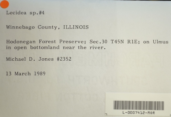
"dwc:verbatimCoordinates": "TRS: T45N R1E Sec. 30",
"dwc:county": "Winnebago",
"dwc:recordedBy": "Michael D. Jones",
"dwc:georeferenceSources": "2016-01-14; Robert Anglin script for Township Range Section in GeoLocate",
"dcterms:references": "https://lichenportal.org/cnalh/collections/individual/index.php?occid=1441314",
"dwc:occurrenceID": "2f9d11c1-4293-4cdc-b257-66eef9a4296b",
"id": "1441314",
"dwc:stateProvince": "Illinois",
"dwc:eventDate": "1989-03-13",
"dwc:collectionID": "36ea544b-df08-4f21-80e5-dd1c0bdc39c6",
"dwc:country": "U.S.A.",
"dwc:georeferenceRemarks": "lat/long = TRS; uncertainty = extent of Section",
"symbiota:recordEnteredBy": "kelueders",
"dwc:decimalLatitude": "42.346149",
"dwc:basisOfRecord": "PreservedSpecimen",
"dc:rights": "http://creativecommons.org/licenses/by-nc/3.0/",
"symbiota:recordID": "2f9d11c1-4293-4cdc-b257-66eef9a4296b",
"dwc:habitat": "in open bottomland near the river; on Ulmus",
"dwc:locality": "Hodonegan Forest Preserve.",
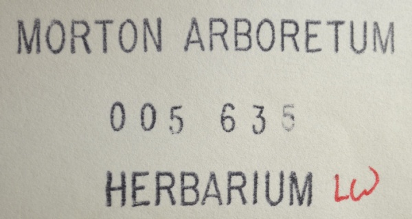
"dwc:institutionCode": "MOR",
"dwc:catalogNumber": "L-0007412-MOR",
"dwc:decimalLongitude": "-89.16469",
"dwc:coordinateUncertaintyInMeters": "1100",
"dwc:otherCatalogNumbers": "5635",
"dwc:georeferencedBy": "ranglin",
"dwc:recordNumber": "2352",
"dcterms:modified": "2016-01-26 10:50:51",
"dwc:scientificName": "Lecanor sp."
},
"indexTerms": {
"recordset": "99b04c9f-908e-42bd-92bc-41aa94b72949",
"dqs": 0.2463768115942029,
"stateprovince": "illinois",
"county": "winnebago",
"catalognumber": "l-0007412-mor",
"startdayofyear": 72,
"collector": "michael d. jones",
"continent": "north america",
"uuid": "2bf1bbfd-e3cc-4a29-b2fc-46fae13beacf",
"countrycode": "usa",
"basisofrecord": "preservedspecimen",
"institutioncode": "mor",
"mediarecords": [
"c90af374-6d35-4a86-a05a-477090faf2c1",
"0c8e110b-738c-4ed5-bde2-81116dcc63b9"
],
"datecollected": "1989-03-13T00:00:00+00:00",
"etag": "43faf68ae8b1e647719fb7f5bc3d0bde17770ec3",
"recordnumber": "2352",
"hasImage": true,
"collectionid": "36ea544b-df08-4f21-80e5-dd1c0bdc39c6",
"scientificname": "lecanor sp.",
"locality": "hodonegan forest preserve.",
"hasMedia": true,
"coordinateuncertainty": 1100,
"datemodified": "2023-01-11T04:06:24.025307+00:00",
"occurrenceid": "2f9d11c1-4293-4cdc-b257-66eef9a4296b",
"country": "united states",
"geopoint": {
"lat": 42.346149,
"lon": -89.16469
},
"flags": [
"geopoint_datum_missing",
"dwc_country_replaced",
"idigbio_isocountrycode_added",
"dwc_continent_added"
],
"recordids": [
"urn:uuid:2f9d11c1-4293-4cdc-b257-66eef9a4296b",
"99b04c9f-908e-42bd-92bc-41aa94b72949\\1441314",
"99b04c9f-908e-42bd-92bc-41aa94b72949\\2f9d11c1-4293-4cdc-b257-66eef9a4296b"
],
"eventdate": "1989-03-13",
"indexData": {
"dwc:verbatimCoordinates": "TRS: T45N R1E Sec. 30",
"dwc:county": "Winnebago",
"dwc:recordedBy": "Michael D. Jones",
"idigbio:uuid": "2bf1bbfd-e3cc-4a29-b2fc-46fae13beacf",
"dwc:locality": "Hodonegan Forest Preserve.",
"dcterms:references": "https://lichenportal.org/cnalh/collections/individual/index.php?occid=1441314",
"idigbio:recordIds": [
"urn:uuid:2f9d11c1-4293-4cdc-b257-66eef9a4296b",
"99b04c9f-908e-42bd-92bc-41aa94b72949\\1441314",
"99b04c9f-908e-42bd-92bc-41aa94b72949\\2f9d11c1-4293-4cdc-b257-66eef9a4296b"
],
"dwc:occurrenceID": "2f9d11c1-4293-4cdc-b257-66eef9a4296b",
"symbiota:recordEnteredBy": "kelueders",
"idigbio:parent": "99b04c9f-908e-42bd-92bc-41aa94b72949",
"dwc:stateProvince": "Illinois",
"dwc:eventDate": "1989-03-13",
"dwc:collectionID": "36ea544b-df08-4f21-80e5-dd1c0bdc39c6",
"dwc:country": "united states",
"idigbio:etag": "43faf68ae8b1e647719fb7f5bc3d0bde17770ec3",
"dwc:georeferenceRemarks": "lat/long = TRS; uncertainty = extent of Section",
"id": "1441314",
"dwc:decimalLatitude": "42.346149",
"dwc:basisOfRecord": "PreservedSpecimen",
"dwc:continent": "north america",
"dc:rights": "http://creativecommons.org/licenses/by-nc/3.0/",
"flag_dwc_country_replaced": true,
"idigbio:siblings": {
"mediarecord": [
"c90af374-6d35-4a86-a05a-477090faf2c1",
"0c8e110b-738c-4ed5-bde2-81116dcc63b9"
]
},
"symbiota:recordID": "2f9d11c1-4293-4cdc-b257-66eef9a4296b",
"flag_idigbio_isocountrycode_added": true,
"dwc:habitat": "in open bottomland near the river; on Ulmus",
"idigbio:dateModified": "2023-01-11T04:06:24.025307",
"dwc:georeferenceSources": "2016-01-14; Robert Anglin script for Township Range Section in GeoLocate",
"dwc:institutionCode": "MOR",
"dwc:catalogNumber": "L-0007412-MOR",
"dwc:decimalLongitude": "-89.16469",
"dwc:scientificName": "Lecanor sp.",
"dwc:otherCatalogNumbers": "5635",
"dwc:georeferencedBy": "ranglin",
"flag_dwc_continent_added": true,
"dwc:recordNumber": "2352",
"idigbio:isocountrycode": "usa",
"dcterms:modified": "2016-01-26 10:50:51",
"dwc:coordinateUncertaintyInMeters": "1100"
}
},
"attribution": {
"uuid": "99b04c9f-908e-42bd-92bc-41aa94b72949",
"name": "Morton Arboretum",
"description": "The Morton Arboretum is an internationally recognized nonprofit organization dedicated to the planting and conservation of trees. Its 1,700 acres hold more than 222,000 live plants representing nearly 4,300 taxa from around the world.",
"logo": "https://lichenportal.org/cnalh/content/collicon/maple_tree_fall.jpg",
"url": "http://www.mortonarb.org/",
"emllink": "https://lichenportal.org/cnalh/content/dwca/mor_dwc-a.eml",
"archivelink": "https://lichenportal.org/cnalh/content/dwca/mor_dwc-a.zip",
"contacts": [
{
"email": "CNALH.help@gmail.com"
},
{
"email": "CNALH.help@gmail.com"
},
{
"email": "Ahipp@mortonarb.org"
},
{
"first_name": null,
"last_name": "Andrew Hipp",
"email": "Ahipp@mortonarb.org"
},
{
"first_name": null,
"last_name": "Andrew Hipp",
"email": "Ahipp@mortonarb.org"
}
],
"data_rights": "CC3 BY-NC",
"publisher": "efd00b2c-5ade-4a90-a95a-3f9188fcfa71",
"totalCount": 17915
}
}
 The Morton Arboretum is an internationally recognized nonprofit organization dedicated to the planting and conservation of trees. Its 1,700 acres hold more than 222,000 live plants representing nearly 4,300 taxa from around the world.