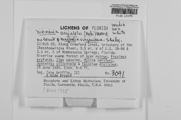
{
"uuid": "29777114-fe1f-4ea7-9a0e-8839912528cc",
"type": "records",
"etag": "3c02cc453103019b40acc68b29077d4b3602f3d2",
"data": {
"dwc:startDayOfYear": "175",
"dwc:county": "Citrus",
"dwc:recordedBy": "Dana Griffin, III & Wade Bryant; Wade Bryant",
"dwc:georeferenceSources": "georef batch tool 2015-07-03; GeoLocate",
"dcterms:references": "http://lichenportal.org/portal/collections/individual/index.php?occid=1738209",
"dwc:occurrenceID": "1738209",
"dwc:dateIdentified": "1995",
"dwc:verbatimElevation": "5-8 ft",
"dwc:verbatimEventDate": "24 June 1994",
"symbiota:recordEnteredBy": "daniellerp",
"dwc:stateProvince": "Florida",
"dwc:eventDate": "1994-06-24",
"dwc:collectionID": "2a40ef36-3117-4295-8c11-a672db19b4a0",
"dwc:country": "United States",
"idigbio:recordId": "urn:uuid:3a67e43c-e623-436d-9f89-04e1a0165049",
"dwc:georeferenceRemarks": "could be anywhere along Crawford Creek",
"dwc:decimalLatitude": "28.695372",
"dwc:georeferenceVerificationStatus": "reviewed - low confidence",
"dwc:maximumElevationInMeters": "2",
"dwc:basisOfRecord": "PreservedSpecimen",
"dc:rights": "http://creativecommons.org/licenses/by-nc/3.0/",
"dwc:identifiedBy": "RCH",
"dwc:coordinateUncertaintyInMeters": "800",
"dwc:habitat": "riverine swamp forest; on trunk of Magnolia virginiana; shady",
"dwc:locality": "along Crawford Creek, tributary of the Chassahowitzka River, 3.5 mi. W of U.S. 19-98 & 5.5 mi. S of Homosassa Springs",
"dwc:institutionCode": "FLAS",
"dwc:catalogNumber": "FLAS L4499",
"dwc:month": "6",
"dwc:decimalLongitude": "-82.604635",
"dwc:scientificName": "Dirnaria aegialita",
"dwc:georeferencedBy": "nickirows (2015-07-03 17:45:58)",
"dwc:day": "24",
"dwc:recordNumber": "3041",
"dwc:minimumElevationInMeters": "2",
"dcterms:modified": "2015-08-11 12:57:11",
"dwc:associatedTaxa": "Acer rubrum, Fraxinus profunda, Ilex cassine, Myrica cerifera, Juniperus silicicola, Taxodiurn distichum, Magnolia virginiana",
"dwc:footprintWKT": "28.705535,-82.61339,28.703954,-82.615707,28.702072,-82.613476,28.700792,-82.609785,28.697781,-82.607468,28.695146,-82.60618,28.694242,-82.605837,28.694167,-82.603262,28.691984,-82.6,28.691908,-82.592705,28.693113,-82.592619,28.694393,-82.601288,28.696426,-82.603262,28.697103,-82.605751,28.7029,-82.608755,28.704557,-82.612961,28.705535,-82.61339",
"dwc:year": "1994"
},
"indexTerms": {
"recordset": "b5e5c781-765f-4981-af2a-c19c250e2cf0",
"dqs": 0.30434782608695654,
"stateprovince": "florida",
"county": "citrus",
"catalognumber": "flas l4499",
"startdayofyear": 175,
"collector": "dana griffin, iii & wade bryant; wade bryant",
"continent": "north america",
"uuid": "29777114-fe1f-4ea7-9a0e-8839912528cc",
"countrycode": "usa",
"basisofrecord": "preservedspecimen",
"institutioncode": "flas",
"mediarecords": [
"ef32aad9-baed-4e7c-bb2a-b802235453a8"
],
"datecollected": "1994-06-24T00:00:00+00:00",
"etag": "3c02cc453103019b40acc68b29077d4b3602f3d2",
"recordnumber": "3041",
"minelevation": 2,
"hasImage": true,
"maxelevation": 2,
"collectionid": "2a40ef36-3117-4295-8c11-a672db19b4a0",
"scientificname": "dirnaria aegialita",
"locality": "along crawford creek, tributary of the chassahowitzka river, 3.5 mi. w of u.s. 19-98 & 5.5 mi. s of homosassa springs",
"hasMedia": true,
"coordinateuncertainty": 800,
"datemodified": "2016-04-07T16:58:19.070485+00:00",
"occurrenceid": "1738209",
"country": "united states",
"geopoint": {
"lat": 28.695372,
"lon": -82.604635
},
"flags": [
"geopoint_datum_missing",
"idigbio_isocountrycode_added",
"dwc_continent_added"
],
"verbatimeventdate": "24 june 1994",
"recordids": [
"urn:uuid:3a67e43c-e623-436d-9f89-04e1a0165049",
"b5e5c781-765f-4981-af2a-c19c250e2cf0\\1738209"
],
"eventdate": "1994-06-24",
"indexData": {
"dwc:startDayOfYear": "175",
"dwc:county": "Citrus",
"dwc:recordedBy": "Dana Griffin, III & Wade Bryant; Wade Bryant",
"idigbio:uuid": "29777114-fe1f-4ea7-9a0e-8839912528cc",
"dwc:locality": "along Crawford Creek, tributary of the Chassahowitzka River, 3.5 mi. W of U.S. 19-98 & 5.5 mi. S of Homosassa Springs",
"dcterms:references": "http://lichenportal.org/portal/collections/individual/index.php?occid=1738209",
"idigbio:recordIds": [
"urn:uuid:3a67e43c-e623-436d-9f89-04e1a0165049",
"b5e5c781-765f-4981-af2a-c19c250e2cf0\\1738209"
],
"dwc:occurrenceID": "1738209",
"dwc:dateIdentified": "1995",
"dwc:verbatimElevation": "5-8 ft",
"symbiota:recordEnteredBy": "daniellerp",
"idigbio:parent": "b5e5c781-765f-4981-af2a-c19c250e2cf0",
"dwc:stateProvince": "Florida",
"dwc:eventDate": "1994-06-24",
"dwc:collectionID": "2a40ef36-3117-4295-8c11-a672db19b4a0",
"dwc:country": "United States",
"idigbio:recordId": "urn:uuid:3a67e43c-e623-436d-9f89-04e1a0165049",
"idigbio:etag": "3c02cc453103019b40acc68b29077d4b3602f3d2",
"dwc:georeferenceRemarks": "could be anywhere along Crawford Creek",
"dwc:decimalLatitude": "28.695372",
"dwc:georeferenceVerificationStatus": "reviewed - low confidence",
"dwc:maximumElevationInMeters": "2",
"dwc:basisOfRecord": "PreservedSpecimen",
"dwc:continent": "north america",
"dc:rights": "http://creativecommons.org/licenses/by-nc/3.0/",
"dwc:identifiedBy": "RCH",
"dwc:associatedTaxa": "Acer rubrum, Fraxinus profunda, Ilex cassine, Myrica cerifera, Juniperus silicicola, Taxodiurn distichum, Magnolia virginiana",
"idigbio:siblings": {
"mediarecord": [
"ef32aad9-baed-4e7c-bb2a-b802235453a8"
]
},
"flag_idigbio_isocountrycode_added": true,
"dwc:habitat": "riverine swamp forest; on trunk of Magnolia virginiana; shady",
"idigbio:dateModified": "2016-04-07T16:58:19.070485",
"dwc:georeferenceSources": "georef batch tool 2015-07-03; GeoLocate",
"dwc:institutionCode": "FLAS",
"dwc:footprintWKT": "28.705535,-82.61339,28.703954,-82.615707,28.702072,-82.613476,28.700792,-82.609785,28.697781,-82.607468,28.695146,-82.60618,28.694242,-82.605837,28.694167,-82.603262,28.691984,-82.6,28.691908,-82.592705,28.693113,-82.592619,28.694393,-82.601288,28.696426,-82.603262,28.697103,-82.605751,28.7029,-82.608755,28.704557,-82.612961,28.705535,-82.61339",
"dwc:catalogNumber": "FLAS L4499",
"dwc:month": "6",
"dwc:decimalLongitude": "-82.604635",
"dwc:scientificName": "Dirnaria aegialita",
"dwc:georeferencedBy": "nickirows (2015-07-03 17:45:58)",
"dwc:verbatimEventDate": "24 June 1994",
"flag_dwc_continent_added": true,
"dwc:recordNumber": "3041",
"idigbio:isocountrycode": "usa",
"dwc:minimumElevationInMeters": "2",
"dcterms:modified": "2015-08-11 12:57:11",
"dwc:coordinateUncertaintyInMeters": "800",
"dwc:day": "24",
"dwc:year": "1994"
}
},
"attribution": {
"uuid": "b5e5c781-765f-4981-af2a-c19c250e2cf0",
"name": "University of Florida Herbarium",
"description": "The University of Florida Herbarium is a unit of the Department of Natural History of the Florida Museum of Natural History. The herbarium is affiliated with the Institute of Food and Agricultural Sciences, Florida Agricultural Experiment Station, Florida Cooperative Extension Service, Department of Biology and the Department of Plant Pathology. The FLAS acronym is the standard international abbreviation for the University of Florida Herbarium. It is derived from the herbarium's early association with the Florida Agricultural Experiment Station. Our mission focuses in plant collections acquisition and care, research based on the collections, education and public service.",
"logo": "http://lichenportal.org/portal/images/collicons/flas.jpg",
"url": "http://www.flmnh.ufl.edu/herbarium/",
"emllink": "http://lichenportal.org/portal/collections/datasets/dwc/flas_dwc-a.eml",
"archivelink": "http://lichenportal.org/portal/collections/datasets/dwc/flas_dwc-a.zip",
"contacts": [
{
"email": "CNALHadmin@asu.edu"
},
{
"first_name": "Kent Perkins, Collection Manager",
"email": "herb@flmnh.ufl.edu"
}
],
"data_rights": "CC3 BY-NC",
"publisher": "efd00b2c-5ade-4a90-a95a-3f9188fcfa71",
"totalCount": 10820
}
}
 The University of Florida Herbarium is a unit of the Department of Natural History of the Florida Museum of Natural History. The herbarium is affiliated with the Institute of Food and Agricultural Sciences, Florida Agricultural Experiment Station, Florida Cooperative Extension Service, Department of Biology and the Department of Plant Pathology. The FLAS acronym is the standard international abbreviation for the University of Florida Herbarium. It is derived from the herbarium's early association with the Florida Agricultural Experiment Station. Our mission focuses in plant collections acquisition and care, research based on the collections, education and public service.