{
"uuid": "257d4bdd-5d76-49e1-bd58-cc0cab87a245",
"type": "records",
"etag": "53f4c05a5d82139d79e55b99a28d331067701f85",
"data": {
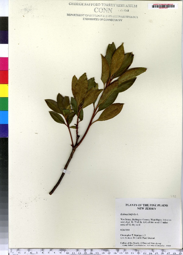
"dwc:specificEpithet": "latifolia",
"dwc:countryCode": "US",
"dwc:county": "Burlington County",
"dwc:recordedBy": "Christopher T. Martine",
"dwc:georeferenceSources": "2006. Google Earth. © Google Earth.",
"dwc:order": "Ericales",
"dwc:habitat": "Dry Sand",
"dwc:occurrenceID": "urn:catalog:UConn:CONN:CONN00110316",
"dwc:verbatimElevation": "117 FT",
"dwc:stateProvince": "New Jersey",
"dwc:eventDate": "2001-08-24",
"dwc:country": "USA",
"dwc:collectionCode": "CONN",
"dwc:verbatimLatitude": "39°47' 36\" N",
"dwc:kingdom": "Dicotyledonae",
"dwc:decimalLatitude": "39.79333",
"dwc:maximumElevationInMeters": "35",
"dwc:basisOfRecord": "Preserved Specimen",
"dwc:genus": "Kalmia",
"dwc:family": "Ericaceae",
"dwc:coordinateUncertaintyInMeters": "5000",
"dwc:municipality": "West Plains",
"dwc:previousIdentifications": "Kalmia latifolia L.",
"dwc:vernacularName": "calico bush; mountain laurel",
"dwc:locationAccordingTo": "minutes added from gazetteer",
"dwc:locality": "West Plains | 1.6 miles west of jct Rt. 72 & Rt. 539, off dirt road 1.3 miles south of 72.",
"dwc:institutionCode": "UConn",
"dwc:reproductiveCondition": "sterile/vegetative",
"dwc:higherClassification": "Plantae; Dicotyledonae; Ericales; Ericaceae",
"dwc:catalogNumber": "CONN00110316",
"dwc:higherGeography": "USA; New Jersey; Burlington County; West Plains",
"dwc:month": "8",
"dwc:decimalLongitude": "-74.40055",
"dwc:verbatimLongitude": "74°24' 02\" W",
"dwc:verbatimEventDate": "24-Aug-01",
"dwc:recordNumber": "117",
"dcterms:rights": "This work is licensed under a Creative Commons CCZero 1.0 License http://i.creativecommons.org/l/by-nc-sa/4.0/88x31.png",
"dwc:minimumElevationInMeters": "35",
"dcterms:modified": "2011-02-21T00:00-0500",
"dwc:scientificName": "Kalmia latifolia L.",
"dwc:day": "24",
"dwc:datasetID": "105373",
"dwc:year": "2001"
},
"indexTerms": {
"family": "ericaceae",
"recordset": "e70af26a-fb9e-43ab-96a0-d62a2df37e6d",
"dqs": 0.4057971014492754,
"stateprovince": "new jersey",
"institutioncode": "uconn",
"municipality": "west plains",
"county": "burlington county",
"catalognumber": "conn00110316",
"startdayofyear": 236,
"specificepithet": "latifolia",
"continent": "north america",
"uuid": "257d4bdd-5d76-49e1-bd58-cc0cab87a245",
"countrycode": "usa",
"basisofrecord": "preservedspecimen",
"collector": "christopher t. martine",
"commonnames": [
"calico bush; mountain laurel"
],
"mediarecords": [
"58e49166-cb0b-48e9-816c-537ef6495e13"
],
"datecollected": "2001-08-24T00:00:00+00:00",
"etag": "53f4c05a5d82139d79e55b99a28d331067701f85",
"recordnumber": "117",
"minelevation": 35,
"hasImage": true,
"kingdom": "dicotyledonae",
"maxelevation": 35,
"highertaxon": "plantae; dicotyledonae; ericales; ericaceae",
"commonname": "calico bush; mountain laurel",
"scientificname": "kalmia latifolia l.",
"locality": "west plains | 1.6 miles west of jct rt. 72 & rt. 539, off dirt road 1.3 miles south of 72.",
"hasMedia": true,
"coordinateuncertainty": 5000,
"datemodified": "2014-09-09T04:31:11.458000+00:00",
"occurrenceid": "urn:catalog:uconn:conn:conn00110316",
"country": "united states",
"geopoint": {
"lat": 39.79333,
"lon": -74.40055
},
"collectioncode": "conn",
"eventdate": "2001-08-24",
"flags": [
"geopoint_datum_missing",
"dwc_continent_added",
"dwc_country_replaced",
"idigbio_isocountrycode_added",
"taxon_match_failed"
],
"verbatimeventdate": "24-aug-01",
"recordids": [
"e70af26a-fb9e-43ab-96a0-d62a2df37e6d\\urn:catalog:uconn:conn:conn00110316"
],
"genus": "kalmia",
"order": "ericales",
"datasetid": "105373",
"indexData": {
"dwc:specificEpithet": "latifolia",
"dwc:countryCode": "US",
"dwc:county": "Burlington County",
"dwc:recordedBy": "Christopher T. Martine",
"idigbio:uuid": "257d4bdd-5d76-49e1-bd58-cc0cab87a245",
"dwc:locationAccordingTo": "minutes added from gazetteer",
"dwc:order": "Ericales",
"dwc:habitat": "Dry Sand",
"idigbio:isocountrycode": "usa",
"dwc:locality": "West Plains | 1.6 miles west of jct Rt. 72 & Rt. 539, off dirt road 1.3 miles south of 72.",
"idigbio:recordIds": [
"e70af26a-fb9e-43ab-96a0-d62a2df37e6d\\urn:catalog:uconn:conn:conn00110316"
],
"dwc:occurrenceID": "urn:catalog:UConn:CONN:CONN00110316",
"dwc:scientificName": "Kalmia latifolia L.",
"dwc:verbatimElevation": "117 FT",
"idigbio:parent": "e70af26a-fb9e-43ab-96a0-d62a2df37e6d",
"dwc:stateProvince": "New Jersey",
"dwc:eventDate": "2001-08-24",
"dwc:country": "united states",
"idigbio:etag": "53f4c05a5d82139d79e55b99a28d331067701f85",
"dwc:collectionCode": "CONN",
"dwc:verbatimLatitude": "39°47' 36\" N",
"dwc:kingdom": "Dicotyledonae",
"dwc:decimalLatitude": "39.79333",
"dwc:maximumElevationInMeters": "35",
"dwc:basisOfRecord": "Preserved Specimen",
"dwc:genus": "Kalmia",
"dwc:continent": "north america",
"dwc:family": "Ericaceae",
"flag_dwc_continent_added": true,
"flag_dwc_country_replaced": true,
"dwc:municipality": "West Plains",
"dwc:previousIdentifications": "Kalmia latifolia L.",
"idigbio:siblings": {
"mediarecord": [
"58e49166-cb0b-48e9-816c-537ef6495e13"
]
},
"flag_idigbio_isocountrycode_added": true,
"dwc:vernacularName": "calico bush; mountain laurel",
"idigbio:dateModified": "2014-09-09T04:31:11.458000",
"dwc:georeferenceSources": "2006. Google Earth. © Google Earth.",
"dwc:institutionCode": "UConn",
"dwc:reproductiveCondition": "sterile/vegetative",
"dwc:higherClassification": "Plantae; Dicotyledonae; Ericales; Ericaceae",
"dwc:catalogNumber": "CONN00110316",
"dwc:higherGeography": "USA; New Jersey; Burlington County; West Plains",
"dwc:month": "8",
"dwc:decimalLongitude": "-74.40055",
"dwc:verbatimLongitude": "74°24' 02\" W",
"dwc:verbatimEventDate": "24-Aug-01",
"dwc:recordNumber": "117",
"dcterms:rights": "This work is licensed under a Creative Commons CCZero 1.0 License http://i.creativecommons.org/l/by-nc-sa/4.0/88x31.png",
"flag_taxon_match_failed": true,
"dwc:minimumElevationInMeters": "35",
"dcterms:modified": "2011-02-21T00:00-0500",
"dwc:coordinateUncertaintyInMeters": "5000",
"dwc:day": "24",
"dwc:datasetID": "105373",
"dwc:year": "2001"
}
},
"attribution": {
"uuid": "e70af26a-fb9e-43ab-96a0-d62a2df37e6d",
"name": "George Safford Torrey Herbarium (CONN)",
"description": "The George Safford Torrey Herbarium (CONN) at the University of Connecticut supports botanical research in all disciplines, including systematics, taxonomy, biodiversity, ecology, ethnobotany, palaeobotany, evolution and education. With a total of slightly more than 200,000 specimens, the collection has representative species from around the world but is particularly strong in species of northeastern North America.",
"url": "http://bgbaseserver.eeb.uconn.edu/",
"emllink": "http://gbifdata.eeb.uconn.edu:7001/ipt/eml.do?r=idigbio1",
"archivelink": "http://gbifdata.eeb.uconn.edu:7001/ipt/archive.do?r=idigbio1",
"contacts": [
{
"first_name": "Robert",
"last_name": "Capers",
"role": "Plant collections manager",
"email": "robert.capers@uconn.edu"
},
{
"first_name": "Robert",
"last_name": "Capers",
"role": "Plant collections manager",
"email": "robert.capers@uconn.edu"
}
],
"data_rights": "No license, assume Public Domain",
"publisher": "b6bd1367-180a-4a50-b86a-ae6f89c59f90",
"totalCount": 172098
}
}