{
"uuid": "1ebfc3dd-56f5-4e18-af17-898e166aaf6f",
"type": "records",
"etag": "e78b089141c2444fcceee2d665b5e1521965f7cc",
"data": {
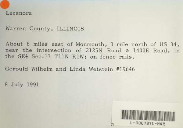
"dwc:verbatimCoordinates": "TRS: T11N R1W SE 1/4 Sec. 17",
"dwc:county": "Warren",
"dwc:recordedBy": "Gerould Wilhelm; Linda Wetstein",
"dwc:georeferenceSources": "2016-01-14; Robert Anglin script for Township Range Section in GeoLocate",
"dcterms:references": "https://lichenportal.org/cnalh/collections/individual/index.php?occid=1441278",
"dwc:scientificNameAuthorship": "Ach.",
"dwc:occurrenceID": "4b7b8620-1362-4906-8d45-b9d535b40d5a",
"id": "1441278",
"dwc:stateProvince": "Illinois",
"dwc:eventDate": "1991-07-08",
"dwc:collectionID": "36ea544b-df08-4f21-80e5-dd1c0bdc39c6",
"dwc:country": "U.S.A.",
"dwc:georeferenceRemarks": "lat/long = TRS; uncertainty = extent of Section",
"symbiota:recordEnteredBy": "kelueders",
"dwc:decimalLatitude": "40.940521",
"dwc:basisOfRecord": "PreservedSpecimen",
"dc:rights": "http://creativecommons.org/licenses/by-nc/3.0/",
"symbiota:recordID": "4b7b8620-1362-4906-8d45-b9d535b40d5a",
"dwc:habitat": "on fence rails",
"dwc:locality": "About 6 miles east of Monmouth, 1 mile north of US 34, near the intersection of 2125N Road & 1400E Road.",
"dwc:institutionCode": "MOR",
"dwc:catalogNumber": "L-0007376-MOR",
"dwc:decimalLongitude": "-90.527332",
"dwc:coordinateUncertaintyInMeters": "1100",
"dwc:otherCatalogNumbers": "[none]",
"dwc:georeferencedBy": "ranglin",
"dwc:recordNumber": "19646",
"dcterms:modified": "2018-03-15 11:21:03",
"dwc:scientificName": "Lecanora sp."
},
"indexTerms": {
"recordset": "99b04c9f-908e-42bd-92bc-41aa94b72949",
"dqs": 0.2463768115942029,
"stateprovince": "illinois",
"county": "warren",
"catalognumber": "l-0007376-mor",
"startdayofyear": 189,
"collector": "gerould wilhelm; linda wetstein",
"continent": "north america",
"uuid": "1ebfc3dd-56f5-4e18-af17-898e166aaf6f",
"countrycode": "usa",
"basisofrecord": "preservedspecimen",
"institutioncode": "mor",
"mediarecords": [
"88623f64-b250-4581-b053-cca33c3b5a1e"
],
"datecollected": "1991-07-08T00:00:00+00:00",
"etag": "e78b089141c2444fcceee2d665b5e1521965f7cc",
"recordnumber": "19646",
"hasImage": true,
"collectionid": "36ea544b-df08-4f21-80e5-dd1c0bdc39c6",
"scientificname": "lecanora sp.",
"locality": "about 6 miles east of monmouth, 1 mile north of us 34, near the intersection of 2125n road & 1400e road.",
"hasMedia": true,
"coordinateuncertainty": 1100,
"datemodified": "2023-01-11T04:06:24.025307+00:00",
"occurrenceid": "4b7b8620-1362-4906-8d45-b9d535b40d5a",
"country": "united states",
"geopoint": {
"lat": 40.940521,
"lon": -90.527332
},
"flags": [
"geopoint_datum_missing",
"dwc_country_replaced",
"idigbio_isocountrycode_added",
"dwc_continent_added"
],
"recordids": [
"urn:uuid:4b7b8620-1362-4906-8d45-b9d535b40d5a",
"99b04c9f-908e-42bd-92bc-41aa94b72949\\1441278",
"99b04c9f-908e-42bd-92bc-41aa94b72949\\4b7b8620-1362-4906-8d45-b9d535b40d5a"
],
"eventdate": "1991-07-08",
"indexData": {
"dwc:verbatimCoordinates": "TRS: T11N R1W SE 1/4 Sec. 17",
"dwc:county": "Warren",
"dwc:recordedBy": "Gerould Wilhelm; Linda Wetstein",
"idigbio:uuid": "1ebfc3dd-56f5-4e18-af17-898e166aaf6f",
"dwc:locality": "About 6 miles east of Monmouth, 1 mile north of US 34, near the intersection of 2125N Road & 1400E Road.",
"dcterms:references": "https://lichenportal.org/cnalh/collections/individual/index.php?occid=1441278",
"dwc:scientificNameAuthorship": "Ach.",
"idigbio:recordIds": [
"urn:uuid:4b7b8620-1362-4906-8d45-b9d535b40d5a",
"99b04c9f-908e-42bd-92bc-41aa94b72949\\1441278",
"99b04c9f-908e-42bd-92bc-41aa94b72949\\4b7b8620-1362-4906-8d45-b9d535b40d5a"
],
"dwc:occurrenceID": "4b7b8620-1362-4906-8d45-b9d535b40d5a",
"symbiota:recordEnteredBy": "kelueders",
"idigbio:parent": "99b04c9f-908e-42bd-92bc-41aa94b72949",
"dwc:stateProvince": "Illinois",
"dwc:eventDate": "1991-07-08",
"dwc:collectionID": "36ea544b-df08-4f21-80e5-dd1c0bdc39c6",
"dwc:country": "united states",
"idigbio:etag": "e78b089141c2444fcceee2d665b5e1521965f7cc",
"dwc:georeferenceRemarks": "lat/long = TRS; uncertainty = extent of Section",
"id": "1441278",
"dwc:decimalLatitude": "40.940521",
"dwc:basisOfRecord": "PreservedSpecimen",
"dwc:continent": "north america",
"dc:rights": "http://creativecommons.org/licenses/by-nc/3.0/",
"flag_dwc_country_replaced": true,
"idigbio:siblings": {
"mediarecord": [
"88623f64-b250-4581-b053-cca33c3b5a1e"
]
},
"symbiota:recordID": "4b7b8620-1362-4906-8d45-b9d535b40d5a",
"flag_idigbio_isocountrycode_added": true,
"dwc:habitat": "on fence rails",
"idigbio:dateModified": "2023-01-11T04:06:24.025307",
"dwc:georeferenceSources": "2016-01-14; Robert Anglin script for Township Range Section in GeoLocate",
"dwc:institutionCode": "MOR",
"dwc:catalogNumber": "L-0007376-MOR",
"dwc:decimalLongitude": "-90.527332",
"dwc:scientificName": "Lecanora sp.",
"dwc:otherCatalogNumbers": "[none]",
"dwc:georeferencedBy": "ranglin",
"flag_dwc_continent_added": true,
"dwc:recordNumber": "19646",
"idigbio:isocountrycode": "usa",
"dcterms:modified": "2018-03-15 11:21:03",
"dwc:coordinateUncertaintyInMeters": "1100"
}
},
"attribution": {
"uuid": "99b04c9f-908e-42bd-92bc-41aa94b72949",
"name": "Morton Arboretum",
"description": "The Morton Arboretum is an internationally recognized nonprofit organization dedicated to the planting and conservation of trees. Its 1,700 acres hold more than 222,000 live plants representing nearly 4,300 taxa from around the world.",
"logo": "https://lichenportal.org/cnalh/content/collicon/maple_tree_fall.jpg",
"url": "http://www.mortonarb.org/",
"emllink": "https://lichenportal.org/cnalh/content/dwca/mor_dwc-a.eml",
"archivelink": "https://lichenportal.org/cnalh/content/dwca/mor_dwc-a.zip",
"contacts": [
{
"email": "CNALH.help@gmail.com"
},
{
"email": "CNALH.help@gmail.com"
},
{
"email": "Ahipp@mortonarb.org"
},
{
"first_name": null,
"last_name": "Andrew Hipp",
"email": "Ahipp@mortonarb.org"
},
{
"first_name": null,
"last_name": "Andrew Hipp",
"email": "Ahipp@mortonarb.org"
}
],
"data_rights": "CC3 BY-NC",
"publisher": "efd00b2c-5ade-4a90-a95a-3f9188fcfa71",
"totalCount": 17915
}
}
 The Morton Arboretum is an internationally recognized nonprofit organization dedicated to the planting and conservation of trees. Its 1,700 acres hold more than 222,000 live plants representing nearly 4,300 taxa from around the world.