{
"uuid": "fb2aacff-e1d5-4061-906f-e8bb45e16e5b",
"type": "records",
"etag": "ea90f1a5b4f717507e750c3eebae4c89f1abed00",
"data": {
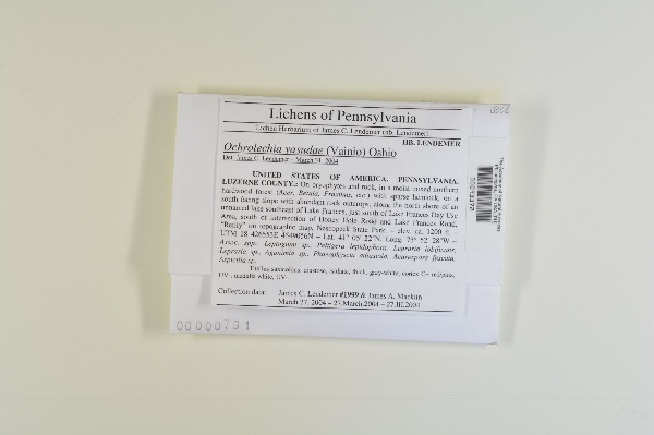
"dwc:specificEpithet": "yasudae",
"dwc:county": "Luzerne",
"dwc:recordedBy": "James C. Lendemer",
"dwc:order": "Pertusariales",
"dwc:habitat": "In a moist mixed northern hardwood forest (Acer, Betula, Fraxinus, etc.) with sparse hemlock, on a south facing slope with abundant rock outcrops.; On bryophytcs and rock.",
"dwc:scientificNameAuthorship": "Vainio",
"dwc:occurrenceID": "1726893",
"dwc:dateIdentified": "2004-03-31",
"dwc:verbatimCoordinates": "41°05'22\"N, 75°52'28\"W; UTM: 18 426553E 4549056N",
"dwc:verbatimElevation": "ca. 1200 ft.",
"symbiota:recordEnteredBy": "xl92",
"dwc:stateProvince": "Pennsylvania",
"dwc:eventDate": "2004-03-27",
"dwc:collectionID": "cb974399-6966-4d9a-9755-515c9c5d0929",
"dwc:country": "USA",
"idigbio:recordId": "urn:uuid:d934f431-021f-44a3-b9f6-ec3b576173c1",
"dwc:kingdom": "Fungi",
"dwc:decimalLatitude": "41.08944",
"dwc:occurrenceRemarks": "The Academy of Natural Sciences of Philadelphia; Lichen Herbarium of James C. Lendemer(hb. Lendemer).; Thallus saxicolous, crustose, isidiate, thick, gray-white; cortex C+ red/pink, UV-; medulla white, UV-.",
"dwc:basisOfRecord": "PreservedSpecimen",
"dwc:genus": "Ochrolechia",
"dwc:family": "Ochrolechiaceae",
"dc:rights": "http://creativecommons.org/licenses/by-nc/3.0/",
"dwc:identifiedBy": "James C. Lendemer",
"dwc:phylum": "Ascomycota",
"dcterms:references": "http://lichenportal.org/portal/collections/individual/index.php?occid=1726893",
"dwc:locality": "Along the north shore of an unnamed lake southeast of Lake Frances, just south of Lake Frances Day Use Area, south of intersection of Honey Hole Road and Lake Frances Road, \"Reilly\" on topographic map, Nescopeck State Park.",
"dwc:institutionCode": "PH",
"dwc:class": "Lecanoromycetes",
"dwc:catalogNumber": "PH00093372",
"dwc:decimalLongitude": "-75.87444",
"dwc:scientificName": "Ochrolechia yasudae",
"dwc:otherCatalogNumbers": "00000791",
"dwc:recordNumber": "1999",
"dwc:minimumElevationInMeters": "366",
"dcterms:modified": "2015-02-05 00:02:11",
"dwc:associatedTaxa": "Leptogium sp., Peltigera lepidophora, Lepraria lobificans, Lepraria sp., Agonimia sp., Phaeophyscia adiastola, Acarospora fuscata, Aspicilia sp."
},
"indexTerms": {
"geopoint": {
"lat": 41.08944,
"lon": -75.87444
},
"family": "ochrolechiaceae",
"recordset": "7110b8ba-0ead-4666-8279-e30f53e343d0",
"dqs": 0.2463768115942029,
"stateprovince": "pennsylvania",
"county": "luzerne",
"phylum": "ascomycota",
"catalognumber": "ph00093372",
"startdayofyear": 87,
"taxonrank": "species",
"specificepithet": "yasudae",
"continent": "north america",
"uuid": "fb2aacff-e1d5-4061-906f-e8bb45e16e5b",
"countrycode": "usa",
"basisofrecord": "preservedspecimen",
"collector": "james c. lendemer",
"institutioncode": "ph",
"mediarecords": [
"2fe0ac4f-f3ea-47f3-8ea2-e726177b8a4e"
],
"datemodified": "2015-09-30T14:28:46.328846+00:00",
"datecollected": "2004-03-27T00:00:00+00:00",
"etag": "ea90f1a5b4f717507e750c3eebae4c89f1abed00",
"recordnumber": "1999",
"minelevation": 366,
"hasImage": true,
"kingdom": "fungi",
"collectionid": "cb974399-6966-4d9a-9755-515c9c5d0929",
"taxonid": "2600225",
"scientificname": "ochrolechia yasudae",
"indexData": {
"flag_dwc_taxonrank_added": true,
"dwc:multimedia": [
{
"dcterms:license": "public domain",
"dcterms:title": "ochrolechia parella",
"dcterms:references": "http://commons.wikimedia.org/wiki/file:ochrolechia_parella.jpg",
"coreid": "2569815",
"dcterms:identifier": "http://upload.wikimedia.org/wikipedia/commons/d/d2/ochrolechia_parella.jpg",
"dcterms:source": "english wikipedia - species pages",
"dcterms:description": "ochrolechia parella, cap sizun, finistère, france",
"dcterms:creator": "jymm",
"dcterms:publisher": "wikimedia commons"
}
],
"dwc:specificEpithet": "yasudae",
"idigbio:dateModified": "2015-09-30T14:28:46.328846",
"dwc:county": "Luzerne",
"dwc:recordedBy": "James C. Lendemer",
"idigbio:uuid": "fb2aacff-e1d5-4061-906f-e8bb45e16e5b",
"flag_dwc_multimedia_added": true,
"dwc:order": "Pertusariales",
"dwc:habitat": "In a moist mixed northern hardwood forest (Acer, Betula, Fraxinus, etc.) with sparse hemlock, on a south facing slope with abundant rock outcrops.; On bryophytcs and rock.",
"flag_gbif_reference_added": true,
"dwc:scientificNameAuthorship": "vain.",
"idigbio:recordIds": [
"urn:uuid:d934f431-021f-44a3-b9f6-ec3b576173c1",
"7110b8ba-0ead-4666-8279-e30f53e343d0\\1726893"
],
"dwc:occurrenceID": "1726893",
"dwc:dateIdentified": "2004-03-31",
"flag_gbif_canonicalname_added": true,
"dwc:verbatimCoordinates": "41°05'22\"N, 75°52'28\"W; UTM: 18 426553E 4549056N",
"dwc:verbatimElevation": "ca. 1200 ft.",
"flag_dwc_taxonomicstatus_added": true,
"flag_gbif_genericname_added": true,
"symbiota:recordEnteredBy": "xl92",
"flag_dwc_datasetid_added": true,
"idigbio:parent": "7110b8ba-0ead-4666-8279-e30f53e343d0",
"dwc:stateProvince": "Pennsylvania",
"dwc:eventDate": "2004-03-27",
"flag_dwc_scientificnameauthorship_replaced": true,
"dwc:collectionID": "cb974399-6966-4d9a-9755-515c9c5d0929",
"dwc:country": "united states",
"idigbio:recordId": "urn:uuid:d934f431-021f-44a3-b9f6-ec3b576173c1",
"idigbio:etag": "ea90f1a5b4f717507e750c3eebae4c89f1abed00",
"flag_gbif_vernacularname_added": true,
"dwc:kingdom": "Fungi",
"dwc:decimalLatitude": "41.08944",
"dwc:occurrenceRemarks": "The Academy of Natural Sciences of Philadelphia; Lichen Herbarium of James C. Lendemer(hb. Lendemer).; Thallus saxicolous, crustose, isidiate, thick, gray-white; cortex C+ red/pink, UV-; medulla white, UV-.",
"dwc:basisOfRecord": "PreservedSpecimen",
"dwc:taxonomicstatus": "accepted",
"dwc:genus": "Ochrolechia",
"dwc:continent": "north america",
"dwc:family": "Ochrolechiaceae",
"dc:rights": "http://creativecommons.org/licenses/by-nc/3.0/",
"dwc:identifiedBy": "James C. Lendemer",
"flag_dwc_country_replaced": true,
"flag_dwc_taxonid_added": true,
"idigbio:isocountrycode": "usa",
"idigbio:siblings": {
"mediarecord": [
"2fe0ac4f-f3ea-47f3-8ea2-e726177b8a4e"
]
},
"flag_idigbio_isocountrycode_added": true,
"gbif:canonicalname": "ochrolechia yasudae",
"dwc:phylum": "Ascomycota",
"dcterms:references": "http://lichenportal.org/portal/collections/individual/index.php?occid=1726893",
"gbif:genericname": "ochrolechia",
"dwc:locality": "Along the north shore of an unnamed lake southeast of Lake Frances, just south of Lake Frances Day Use Area, south of intersection of Honey Hole Road and Lake Frances Road, \"Reilly\" on topographic map, Nescopeck State Park.",
"dwc:institutionCode": "PH",
"flag_gbif_taxon_corrected": true,
"dwc:parentnameusageid": "2569815",
"dwc:class": "Lecanoromycetes",
"dwc:catalogNumber": "PH00093372",
"dwc:taxonid": "2600225",
"dwc:taxonrank": "species",
"dwc:decimalLongitude": "-75.87444",
"dwc:associatedTaxa": "Leptogium sp., Peltigera lepidophora, Lepraria lobificans, Lepraria sp., Agonimia sp., Phaeophyscia adiastola, Acarospora fuscata, Aspicilia sp.",
"dwc:otherCatalogNumbers": "00000791",
"flag_dwc_continent_added": true,
"dwc:recordNumber": "1999",
"dwc:datasetid": "7ddf754f-d193-4cc9-b351-99906754a03b",
"flag_dwc_parentnameusageid_added": true,
"dwc:minimumElevationInMeters": "366",
"dcterms:modified": "2015-02-05 00:02:11",
"dwc:scientificName": "Ochrolechia yasudae",
"gbif:reference": [
{
"coreid": "2600225",
"dcterms:source": "catalogue of life",
"dcterms:bibliographiccitation": "vain. (1918) in: bot. mag. (tokyo) vol.: 32 p. 155"
}
],
"gbif:vernacularname": [
{
"dwc:countrycode": "ca",
"dwc:country": "canada",
"dwc:vernacularname": "coral saucer lichen",
"coreid": "2600225",
"dcterms:source": "catalogue of life",
"dcterms:language": "en"
},
{
"dwc:countrycode": "ca",
"dwc:country": "canada",
"dwc:vernacularname": "ochroléchie de yasuda",
"coreid": "2600225",
"dcterms:source": "catalogue of life",
"dcterms:language": "fr"
}
]
},
"hasMedia": true,
"class": "lecanoromycetes",
"occurrenceid": "1726893",
"country": "united states",
"locality": "along the north shore of an unnamed lake southeast of lake frances, just south of lake frances day use area, south of intersection of honey hole road and lake frances road, \"reilly\" on topographic map, nescopeck state park.",
"canonicalname": "ochrolechia yasudae",
"eventdate": "2004-03-27",
"flags": [
"geopoint_datum_missing",
"dwc_taxonrank_added",
"dwc_multimedia_added",
"gbif_reference_added",
"gbif_canonicalname_added",
"dwc_taxonomicstatus_added",
"gbif_genericname_added",
"dwc_datasetid_added",
"dwc_scientificnameauthorship_replaced",
"gbif_vernacularname_added",
"dwc_country_replaced",
"dwc_taxonid_added",
"idigbio_isocountrycode_added",
"gbif_taxon_corrected",
"dwc_continent_added",
"dwc_parentnameusageid_added"
],
"taxonomicstatus": "accepted",
"recordids": [
"urn:uuid:d934f431-021f-44a3-b9f6-ec3b576173c1",
"7110b8ba-0ead-4666-8279-e30f53e343d0\\1726893"
],
"genus": "ochrolechia",
"order": "pertusariales",
"datasetid": "7ddf754f-d193-4cc9-b351-99906754a03b"
},
"attribution": {
"totalCount": 17839
}
}