{
"uuid": "f1416e21-8fb7-42b0-b879-90e31cb12b56",
"type": "records",
"etag": "90bdb1066d41559e341902b5af9c0c292c07a269",
"data": {
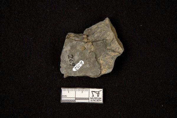
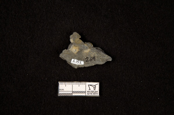
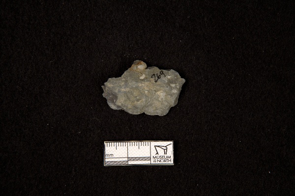
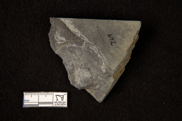
"dwc:identificationRemarks": "Crurithyris sp.; Former nature_of_id: field.",
"dwc:verbatimCoordinates": "63.280604/-145.869943",
"dwc:kingdom": "Animalia",
"dwc:recordedBy": "Collector(s): Arthur W. Rose",
"dwc:georeferencedDate": "2013-10-26 00:00:00",
"dcterms:references": "http://arctos.database.museum/guid/UAM:ES:33141",
"dcterms:accessRights": "http://vertnet.org/resources/norms.html",
"dwc:occurrenceID": "http://arctos.database.museum/guid/UAM:ES:33141?seid=2031558",
"dwc:dateIdentified": "1964",
"id": "http://arctos.database.museum/guid/UAM:ES:33141?seid=2031558",
"dwc:establishmentMeans": "wild",
"dwc:minimumElevationInMeters": "914",
"dwc:stateProvince": "Alaska",
"dwc:locationRemarks": "Limestone and black shales of Mankomen Formation",
"dwc:eventDate": "1964-01-01/1965-12-31",
"dwc:collectionID": "21",
"dwc:institutionCode": "UAM",
"dwc:country": "United States",
"dwc:earliestPeriodOrLowestSystem": "Permian",
"dwc:collectionCode": "ES",
"dwc:higherClassification": "Animalia, Brachiopoda,",
"dwc:decimalLatitude": "63.2806040000",
"dwc:georeferenceVerificationStatus": "unverified",
"dwc:maximumElevationInMeters": "1067",
"dwc:basisOfRecord": "PreservedSpecimen",
"dwc:preparations": "exoskeleton",
"dwc:identifiedBy": "Arthur W. Rose",
"dwc:identificationVerificationStatus": "features",
"dwc:georeferenceSources": "GeoLocate",
"dwc:previousIdentifications": "[{\"scientific_name\":\"Rhynchonellata\",\"nature_of_id\":\"features\",\"accepted_id_fg\":1,\"made_date\":\"1964\",\"short_citation\":null,\"publication_id\":null,\"identification_remarks\":\"Crurithyris sp.; Former nature_of_id: field.\",\"idby\":\"Arthur W. Rose\",\"concept_label\":null}]",
"dwc:eventRemarks": "Four large (>3.5cm) samples, with the rest being too small for the camera lens to focus on",
"dwc:organismID": "http://arctos.database.museum/guid/UAM:ES:33141",
"dwc:phylum": "Brachiopoda",
"dwc:locationAccordingTo": "Bobby Ebelhar",
"dwc:locality": "Rainy Creek area of Alaska range, west of Delta River, elevation between 3000 and 3500 ft, south of the Rainy Creek channel, Mt. Hayes Quad",
"dwc:institutionID": "UAM",
"dwc:associatedMedia": "http://arctos.database.museum/MediaSearch.cfm?collection_object_id=22911826",
"dwc:geodeticDatum": "World Geodetic System 1984",
"dwc:taxonRank": "class",
"dwc:class": "Rhynchonellata",
"dwc:catalogNumber": "UAM:ES:33141",
"dwc:nomenclaturalCode": "ICZN",
"dwc:higherGeography": "United States, Alaska",
"dwc:decimalLongitude": "-145.8699430000",
"dwc:coordinateUncertaintyInMeters": "389",
"dwc:otherCatalogNumbers": "collector number=F269, other identifier=A-152",
"dwc:verbatimLocality": "See map in file",
"dwc:georeferencedBy": "Bobby Ebelhar",
"dwc:verbatimEventDate": "1964-1965",
"dwc:eventTime": "1964-01-01/1965-12-31",
"dwc:recordNumber": "F269",
"dwc:identificationQualifier": "A",
"dwc:verbatimCoordinateSystem": "decimal degrees",
"dwc:georeferenceProtocol": "GeoLocate",
"dcterms:modified": "2022-10-26 08:49:39.847282",
"dwc:scientificName": "Rhynchonellata",
"dwc:footprintWKT": "POLYGON((-145.862190233182 63.2805422872249,-145.862366027868 63.2798625027991,-145.86283297898 63.2792112204597,-145.863573125022 63.2786134658592,-145.864558011735 63.2780922063804,-145.865749787236 63.2776674691207,-145.86710265713 63.2773555719634,-145.868564643627 63.2771684971808,-145.870079581151 63.2771134315343,-145.871589272055 63.2771924904586,-145.873035719994 63.2774026368752,-145.874363355612 63.2777357977357,-145.875521169485 63.2781791738447,-145.876464670726 63.2787157311188,-145.877157596251 63.2793248544948,-145.877573305085 63.2799831394651,-145.877695804027 63.2806652909271,-145.877520364952 63.2813450948914,-145.877053709649 63.2819964257622,-145.876313754579 63.2825942504986,-145.875328924925 63.2831155910401,-145.874137063886 63.2835404079485,-145.872783978878 63.2838523712145,-145.871321680441 63.2840394885013,-145.86980638164 63.2840945665769,-145.868296335124 63.2840154881141,-145.866849591377 63.2838052931661,-145.865521764788 63.2834720621698,-145.864363893855 63.283028604998,-145.863420478152 63.2824919680752,-145.862727767741 63.2818827785905,-145.862312370847 63.2812244511159,-145.862190233182 63.2805422872249))"
},
"indexTerms": {
"datemodified": "2022-12-07T00:43:16.130603+00:00",
"recordset": "2ec3b31e-c86b-4ce9-b265-77c8c3f9643c",
"dqs": 0.391304347826087,
"stateprovince": "alaska",
"earliestperiodorlowestsystem": "permian",
"phylum": "brachiopoda",
"catalognumber": "uam:es:33141",
"taxonrank": "class",
"collector": "collector(s): arthur w. rose",
"verbatimlocality": "see map in file",
"uuid": "f1416e21-8fb7-42b0-b879-90e31cb12b56",
"countrycode": "usa",
"basisofrecord": "preservedspecimen",
"institutioncode": "uam",
"mediarecords": [
"f201eddb-428e-4016-9e91-1ac8a3b646ed",
"de9a71bc-af25-4d73-beee-3cca9ddaa6a7",
"e594d994-7e52-444f-863b-ee0f301a43df",
"e226d41f-e369-47f9-a277-2779df99035e"
],
"continent": "north america",
"etag": "90bdb1066d41559e341902b5af9c0c292c07a269",
"recordnumber": "f269",
"minelevation": 914,
"hasImage": true,
"kingdom": "animalia",
"maxelevation": 1067,
"highertaxon": "animalia, brachiopoda,",
"collectionid": "21",
"scientificname": "rhynchonellata",
"locality": "rainy creek area of alaska range, west of delta river, elevation between 3000 and 3500 ft, south of the rainy creek channel, mt. hayes quad",
"hasMedia": true,
"coordinateuncertainty": 389,
"class": "rhynchonellata",
"occurrenceid": "http://arctos.database.museum/guid/uam:es:33141?seid=2031558",
"institutionid": "uam",
"country": "united states",
"geopoint": {
"lat": 63.280604,
"lon": -145.869943
},
"collectioncode": "es",
"flags": [
"geopoint_datum_error",
"dwc_continent_added",
"idigbio_isocountrycode_added"
],
"verbatimeventdate": "1964-1965",
"recordids": [
"2ec3b31e-c86b-4ce9-b265-77c8c3f9643c\\urn:occurrence:arctos:uam:es:33141:2031558",
"2ec3b31e-c86b-4ce9-b265-77c8c3f9643c\\http://arctos.database.museum/guid/uam:es:33141?seid=2031558"
],
"eventdate": "1964-01-01/1965-12-31",
"indexData": {
"dwc:identificationRemarks": "Crurithyris sp.; Former nature_of_id: field.",
"dwc:georeferenceProtocol": "GeoLocate",
"dwc:verbatimCoordinates": "63.280604/-145.869943",
"idigbio:dateModified": "2022-12-07T00:43:16.130603",
"dwc:kingdom": "Animalia",
"dwc:recordedBy": "Collector(s): Arthur W. Rose",
"idigbio:uuid": "f1416e21-8fb7-42b0-b879-90e31cb12b56",
"dwc:georeferencedDate": "2013-10-26 00:00:00",
"dcterms:references": "http://arctos.database.museum/guid/UAM:ES:33141",
"idigbio:isocountrycode": "usa",
"dcterms:accessRights": "http://vertnet.org/resources/norms.html",
"dwc:locality": "Rainy Creek area of Alaska range, west of Delta River, elevation between 3000 and 3500 ft, south of the Rainy Creek channel, Mt. Hayes Quad",
"idigbio:recordIds": [
"2ec3b31e-c86b-4ce9-b265-77c8c3f9643c\\urn:occurrence:arctos:uam:es:33141:2031558",
"2ec3b31e-c86b-4ce9-b265-77c8c3f9643c\\http://arctos.database.museum/guid/uam:es:33141?seid=2031558"
],
"dwc:occurrenceID": "http://arctos.database.museum/guid/UAM:ES:33141?seid=2031558",
"dwc:dateIdentified": "1964",
"id": "http://arctos.database.museum/guid/UAM:ES:33141?seid=2031558",
"dwc:establishmentMeans": "wild",
"idigbio:parent": "2ec3b31e-c86b-4ce9-b265-77c8c3f9643c",
"dwc:stateProvince": "Alaska",
"dwc:taxonRank": "class",
"dwc:eventDate": "1964-01-01/1965-12-31",
"dwc:collectionID": "21",
"dwc:country": "United States",
"dwc:earliestPeriodOrLowestSystem": "Permian",
"idigbio:etag": "90bdb1066d41559e341902b5af9c0c292c07a269",
"dwc:collectionCode": "ES",
"dwc:class": "Rhynchonellata",
"dwc:decimalLatitude": "63.2806040000",
"dwc:georeferenceVerificationStatus": "unverified",
"dwc:maximumElevationInMeters": "1067",
"dwc:basisOfRecord": "PreservedSpecimen",
"dwc:continent": "north america",
"dwc:preparations": "exoskeleton",
"flag_dwc_continent_added": true,
"dwc:identifiedBy": "Arthur W. Rose",
"dwc:identificationVerificationStatus": "features",
"dwc:previousIdentifications": "[{\"scientific_name\":\"Rhynchonellata\",\"nature_of_id\":\"features\",\"accepted_id_fg\":1,\"made_date\":\"1964\",\"short_citation\":null,\"publication_id\":null,\"identification_remarks\":\"Crurithyris sp.; Former nature_of_id: field.\",\"idby\":\"Arthur W. Rose\",\"concept_label\":null}]",
"dwc:geodeticDatum": "World Geodetic System 1984",
"idigbio:siblings": {
"mediarecord": [
"f201eddb-428e-4016-9e91-1ac8a3b646ed",
"de9a71bc-af25-4d73-beee-3cca9ddaa6a7",
"e594d994-7e52-444f-863b-ee0f301a43df",
"e226d41f-e369-47f9-a277-2779df99035e"
]
},
"dwc:eventRemarks": "Four large (>3.5cm) samples, with the rest being too small for the camera lens to focus on",
"flag_idigbio_isocountrycode_added": true,
"dwc:organismID": "http://arctos.database.museum/guid/UAM:ES:33141",
"dwc:phylum": "Brachiopoda",
"dwc:locationAccordingTo": "Bobby Ebelhar",
"dwc:georeferenceSources": "GeoLocate",
"dwc:institutionID": "UAM",
"dwc:associatedMedia": "http://arctos.database.museum/MediaSearch.cfm?collection_object_id=22911826",
"dwc:institutionCode": "UAM",
"dwc:locationRemarks": "Limestone and black shales of Mankomen Formation",
"dwc:higherClassification": "Animalia, Brachiopoda,",
"dwc:catalogNumber": "UAM:ES:33141",
"dwc:nomenclaturalCode": "ICZN",
"dwc:higherGeography": "United States, Alaska",
"dwc:decimalLongitude": "-145.8699430000",
"dwc:scientificName": "Rhynchonellata",
"dwc:otherCatalogNumbers": "collector number=F269, other identifier=A-152",
"dwc:verbatimLocality": "See map in file",
"dwc:georeferencedBy": "Bobby Ebelhar",
"dwc:verbatimEventDate": "1964-1965",
"dwc:eventTime": "1964-01-01/1965-12-31",
"dwc:recordNumber": "F269",
"dwc:identificationQualifier": "A",
"dwc:verbatimCoordinateSystem": "decimal degrees",
"dwc:minimumElevationInMeters": "914",
"dcterms:modified": "2022-10-26 08:49:39.847282",
"dwc:coordinateUncertaintyInMeters": "389",
"dwc:footprintWKT": "POLYGON((-145.862190233182 63.2805422872249,-145.862366027868 63.2798625027991,-145.86283297898 63.2792112204597,-145.863573125022 63.2786134658592,-145.864558011735 63.2780922063804,-145.865749787236 63.2776674691207,-145.86710265713 63.2773555719634,-145.868564643627 63.2771684971808,-145.870079581151 63.2771134315343,-145.871589272055 63.2771924904586,-145.873035719994 63.2774026368752,-145.874363355612 63.2777357977357,-145.875521169485 63.2781791738447,-145.876464670726 63.2787157311188,-145.877157596251 63.2793248544948,-145.877573305085 63.2799831394651,-145.877695804027 63.2806652909271,-145.877520364952 63.2813450948914,-145.877053709649 63.2819964257622,-145.876313754579 63.2825942504986,-145.875328924925 63.2831155910401,-145.874137063886 63.2835404079485,-145.872783978878 63.2838523712145,-145.871321680441 63.2840394885013,-145.86980638164 63.2840945665769,-145.868296335124 63.2840154881141,-145.866849591377 63.2838052931661,-145.865521764788 63.2834720621698,-145.864363893855 63.283028604998,-145.863420478152 63.2824919680752,-145.862727767741 63.2818827785905,-145.862312370847 63.2812244511159,-145.862190233182 63.2805422872249))"
}
},
"attribution": {
"totalCount": 51496
}
}