{
"uuid": "eaa112df-168e-4fa9-9162-9c13b77a0d50",
"type": "records",
"etag": "e11a6f385e30e5383ce1267bf5e6c65d48ec3e9c",
"data": {
"dwc:countryCode": "HN",
"dwc:county": "Tela",
"dwc:recordedBy": "H.W. Pfeifer",
"dwc:georeferenceSources": "no date. USGS Geographic Names Information System (GNIS). U. S. Geological Survey.",
"dwc:order": "Rubiales",
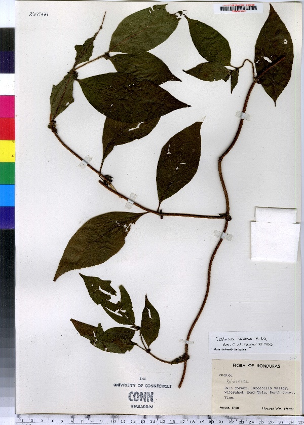
"dwc:habitat": "Rain forest.",
"dwc:occurrenceID": "urn:catalog:UConn:CONN:CONN00163156",
"dwc:stateProvince": "Atlántida",
"dwc:eventDate": "1960-Aug",
"dwc:country": "Honduras",
"dwc:collectionCode": "CONN",
"dwc:verbatimLatitude": "15°42' 00 N",
"dwc:kingdom": "Dicotyledonae",
"dwc:decimalLatitude": "15.7",
"dwc:occurrenceRemarks": "Vine.",
"dwc:basisOfRecord": "Preserved Specimen",
"dwc:genus": "Sabicea",
"dwc:family": "Rubiaceae",
"dwc:coordinateUncertaintyInMeters": "20000",
"dwc:municipality": "Tela",
"dwc:previousIdentifications": "Sabicea Aubl.",
"dwc:locationAccordingTo": "seconds added from gazetteer",
"dwc:locality": "Lancetilla Valley. Watershed, near Tela, North Coast.",
"dwc:institutionCode": "UConn",
"dwc:reproductiveCondition": "fruiting",
"dwc:higherClassification": "Plantae; Dicotyledonae; Rubiales; Rubiaceae",
"dwc:catalogNumber": "CONN00163156",
"dwc:higherGeography": "Honduras; Atlántida; Tela; Tela",
"dwc:month": "8",
"dwc:decimalLongitude": "-87.46666",
"dwc:verbatimLongitude": "87°28' 00 W",
"dwc:verbatimEventDate": "Aug 1960",
"dwc:recordNumber": "2031",
"dcterms:rights": "This work is licensed under a Creative Commons CCZero 1.0 License http://i.creativecommons.org/l/by-nc-sa/4.0/88x31.png",
"dcterms:modified": "2012-12-19T00:00-0500",
"dwc:scientificName": "Sabicea villosa Willd. ex Roem. & Schult.",
"dwc:datasetID": "168266",
"dwc:year": "1960"
},
"indexTerms": {
"geopoint": {
"lat": 15.7,
"lon": -87.46666
},
"family": "rubiaceae",
"recordset": "e70af26a-fb9e-43ab-96a0-d62a2df37e6d",
"dqs": 0.34782608695652173,
"stateprovince": "atlántida",
"municipality": "tela",
"county": "tela",
"catalognumber": "conn00163156",
"startdayofyear": 220,
"collector": "h.w. pfeifer",
"continent": "north america",
"uuid": "eaa112df-168e-4fa9-9162-9c13b77a0d50",
"countrycode": "hnd",
"basisofrecord": "preservedspecimen",
"institutioncode": "uconn",
"mediarecords": [
"74f337e4-70f8-47c9-a420-89073ab1ea83"
],
"datecollected": "1960-08-07T00:00:00+00:00",
"etag": "e11a6f385e30e5383ce1267bf5e6c65d48ec3e9c",
"recordnumber": "2031",
"hasImage": true,
"kingdom": "dicotyledonae",
"highertaxon": "plantae; dicotyledonae; rubiales; rubiaceae",
"scientificname": "sabicea villosa willd. ex roem. & schult.",
"indexData": {
"dwc:countryCode": "HN",
"dwc:county": "Tela",
"dwc:recordedBy": "H.W. Pfeifer",
"idigbio:uuid": "eaa112df-168e-4fa9-9162-9c13b77a0d50",
"dwc:georeferenceSources": "no date. USGS Geographic Names Information System (GNIS). U. S. Geological Survey.",
"dwc:order": "Rubiales",
"dwc:habitat": "Rain forest.",
"idigbio:isocountrycode": "hnd",
"dwc:locality": "Lancetilla Valley. Watershed, near Tela, North Coast.",
"idigbio:recordIds": [
"e70af26a-fb9e-43ab-96a0-d62a2df37e6d\\urn:catalog:uconn:conn:conn00163156"
],
"dwc:occurrenceID": "urn:catalog:UConn:CONN:CONN00163156",
"dwc:scientificName": "Sabicea villosa Willd. ex Roem. & Schult.",
"idigbio:parent": "e70af26a-fb9e-43ab-96a0-d62a2df37e6d",
"dwc:stateProvince": "Atlántida",
"dwc:eventDate": "1960-Aug",
"dwc:country": "Honduras",
"idigbio:etag": "e11a6f385e30e5383ce1267bf5e6c65d48ec3e9c",
"dwc:collectionCode": "CONN",
"dwc:verbatimLatitude": "15°42' 00 N",
"dwc:kingdom": "Dicotyledonae",
"dwc:decimalLatitude": "15.7",
"dwc:occurrenceRemarks": "Vine.",
"dwc:basisOfRecord": "Preserved Specimen",
"dwc:genus": "Sabicea",
"dwc:continent": "north america",
"dwc:family": "Rubiaceae",
"flag_dwc_continent_added": true,
"dwc:municipality": "Tela",
"dwc:previousIdentifications": "Sabicea Aubl.",
"idigbio:siblings": {
"mediarecord": [
"74f337e4-70f8-47c9-a420-89073ab1ea83"
]
},
"flag_idigbio_isocountrycode_added": true,
"idigbio:dateModified": "2014-09-09T04:27:18.683000",
"dwc:locationAccordingTo": "seconds added from gazetteer",
"dwc:institutionCode": "UConn",
"dwc:reproductiveCondition": "fruiting",
"dwc:higherClassification": "Plantae; Dicotyledonae; Rubiales; Rubiaceae",
"dwc:catalogNumber": "CONN00163156",
"dwc:higherGeography": "Honduras; Atlántida; Tela; Tela",
"dwc:month": "8",
"dwc:decimalLongitude": "-87.46666",
"dwc:verbatimLongitude": "87°28' 00 W",
"dwc:verbatimEventDate": "Aug 1960",
"dwc:recordNumber": "2031",
"dcterms:rights": "This work is licensed under a Creative Commons CCZero 1.0 License http://i.creativecommons.org/l/by-nc-sa/4.0/88x31.png",
"flag_taxon_match_failed": true,
"dcterms:modified": "2012-12-19T00:00-0500",
"dwc:coordinateUncertaintyInMeters": "20000",
"dwc:datasetID": "168266",
"dwc:year": "1960"
},
"hasMedia": true,
"coordinateuncertainty": 20000,
"datemodified": "2014-09-09T04:27:18.683000+00:00",
"occurrenceid": "urn:catalog:uconn:conn:conn00163156",
"country": "honduras",
"locality": "lancetilla valley. watershed, near tela, north coast.",
"collectioncode": "conn",
"eventdate": "1960-aug",
"flags": [
"geopoint_datum_missing",
"geopoint_low_precision",
"dwc_continent_added",
"idigbio_isocountrycode_added",
"taxon_match_failed"
],
"verbatimeventdate": "aug 1960",
"recordids": [
"e70af26a-fb9e-43ab-96a0-d62a2df37e6d\\urn:catalog:uconn:conn:conn00163156"
],
"genus": "sabicea",
"order": "rubiales",
"datasetid": "168266"
},
"attribution": {
"totalCount": 172098
}
}