{
"uuid": "e4979b72-8f93-491f-a8b0-3238b5d3ec40",
"type": "records",
"etag": "cb46a85a799844b2eeb61d955a12bbdaaa155513",
"data": {
"dwc:identificationRemarks": "Former nature_of_id: student.",
"dwc:verbatimCoordinates": "65d 7m 15s /147d 32m 0s",
"dwc:kingdom": "Animalia",
"dwc:recordedBy": "Collector(s): Paul Metz",
"dwc:georeferencedDate": "1979-12-31 00:00:00",
"dcterms:references": "http://arctos.database.museum/guid/UAM:ES:5003",
"dcterms:accessRights": "http://vertnet.org/resources/norms.html",
"dwc:occurrenceID": "http://arctos.database.museum/guid/UAM:ES:5003?seid=245282",
"dwc:earliestEpochOrLowestSeries": "Pleistocene",
"id": "http://arctos.database.museum/guid/UAM:ES:5003?seid=245282",
"dwc:establishmentMeans": "wild",
"dwc:stateProvince": "Alaska",
"dwc:eventDate": "1979-07-01/1979-07-31",
"dwc:collectionID": "21",
"dwc:institutionCode": "UAM",
"dwc:country": "United States",
"dwc:earliestPeriodOrLowestSystem": "Quaternary",
"dwc:collectionCode": "ES",
"dwc:higherClassification": "Animalia, Chordata,",
"dwc:decimalLatitude": "65.0680330000",
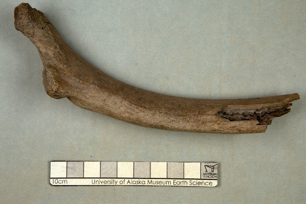
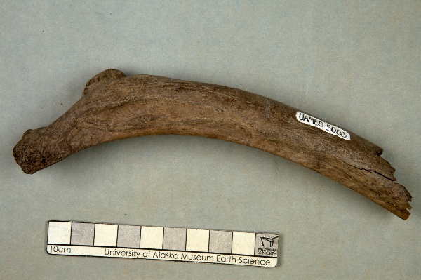
"dwc:occurrenceRemarks": "Proximal rib fragment preserving tuberculum and capitulum as well as proximal end of rib shaft. Tool marks (cut marks?) located near specimen label: 3-4 parallel grooves in surface of rib, form distinct low spot when looking at rib in side view. Current location (as of 6/14/2010): one of 16 boxes labeled V-67, Range 10, Bay 6, Shelves 2-4",
"dwc:georeferenceVerificationStatus": "unverified",
"dwc:basisOfRecord": "PreservedSpecimen",
"dwc:preparations": "rib",
"dwc:identifiedBy": "Katherine L. Anderson",
"dwc:identificationVerificationStatus": "features",
"dwc:georeferenceSources": "GeoLocate",
"dwc:previousIdentifications": "[{\"scientific_name\":\"Mammalia\",\"nature_of_id\":\"features\",\"accepted_id_fg\":1,\"made_date\":null,\"short_citation\":null,\"publication_id\":null,\"identification_remarks\":\"Former nature_of_id: student.\",\"idby\":\"Katherine L. Anderson\",\"concept_label\":null},{\"scientific_name\":\"unidentifiable\",\"nature_of_id\":\"features\",\"accepted_id_fg\":0,\"made_date\":null,\"short_citation\":null,\"publication_id\":null,\"identification_remarks\":\"Former nature_of_id: field.\",\"idby\":\"Paul Metz\",\"concept_label\":null}]",
"dwc:organismID": "http://arctos.database.museum/guid/UAM:ES:5003",
"dwc:phylum": "Chordata",
"dwc:locationAccordingTo": "unknown",
"dwc:locality": "Near the confluence of Cleary Creek and Bedrock Creek, Livengood Quad",
"dwc:institutionID": "UAM",
"dwc:associatedMedia": "http://arctos.database.museum/MediaSearch.cfm?collection_object_id=21682667",
"dwc:geodeticDatum": "unknown",
"dwc:taxonRank": "class",
"dwc:class": "Mammalia",
"dwc:catalogNumber": "UAM:ES:5003",
"dwc:nomenclaturalCode": "ICZN",
"dwc:higherGeography": "United States, Alaska",
"dwc:decimalLongitude": "-147.4457860000",
"dwc:coordinateUncertaintyInMeters": "864",
"dwc:otherCatalogNumbers": "Locality ID=A-1444, other identifier=AK-67-V-",
"dwc:verbatimLocality": "In the area of the confluence of Cleary Creek and Bedrock Creek",
"dwc:georeferencedBy": "unknown",
"dwc:verbatimEventDate": "July 1979",
"dwc:eventTime": "1979-07-01/1979-07-31",
"dwc:identificationQualifier": "A",
"dwc:verbatimCoordinateSystem": "deg. min. sec.",
"dwc:georeferenceProtocol": "GeoLocate",
"dcterms:modified": "2022-10-25 11:04:27.376775",
"dwc:scientificName": "Mammalia",
"dwc:footprintWKT": "POLYGON((-147.427417876379 65.0680865688291,-147.427746555716 65.0665731801977,-147.42876836875 65.0651159293203,-147.43044394825 65.0637708040267,-147.432708835328 65.0625894762371,-147.435475966784 65.0616173193585,-147.438639024669 65.0608916683177,-147.442076518757 65.0604403885299,-147.445656445561 65.0602808082329,-147.449241346322 65.0604190547305,-147.452693571856 65.0608498197256,-147.45588055461 65.061556562641,-147.458679888021 65.0625121442145,-147.460984020266 65.0636798663315,-147.462704383611 65.0650148786096,-147.463774801235 65.0664658982414,-147.464154040121 65.0679771775717,-147.463827410449 65.0694906442828,-147.46280734775 65.0709481322713,-147.461132952781 65.0722936176092,-147.458868504098 65.0734753735632,-147.456100998156 65.0744479615418,-147.452936809919 65.0751739809874,-147.449497601697 65.0756255103983,-147.445915637939 65.0757851835339,-147.442328687512 65.0756468589567,-147.438874711644 65.0752158568505,-147.435686544358 65.0745087538906,-147.432886772554 65.0735527441528,-147.430583014794 65.0723845909357,-147.428863781801 65.0710492102529,-147.427795078312 65.0695979409981,-147.427417876379 65.0680865688291))"
},
"indexTerms": {
"datemodified": "2022-12-07T00:43:16.130603+00:00",
"recordset": "2ec3b31e-c86b-4ce9-b265-77c8c3f9643c",
"dqs": 0.34782608695652173,
"stateprovince": "alaska",
"earliestepochorlowestseries": "pleistocene",
"earliestperiodorlowestsystem": "quaternary",
"phylum": "chordata",
"catalognumber": "uam:es:5003",
"taxonrank": "class",
"collector": "collector(s): paul metz",
"verbatimlocality": "in the area of the confluence of cleary creek and bedrock creek",
"uuid": "e4979b72-8f93-491f-a8b0-3238b5d3ec40",
"countrycode": "usa",
"basisofrecord": "preservedspecimen",
"institutioncode": "uam",
"mediarecords": [
"0a6389f9-8e19-4b28-89e0-8007e428591d",
"e9de58d8-ba34-414c-9326-a12a290c4043"
],
"continent": "north america",
"etag": "cb46a85a799844b2eeb61d955a12bbdaaa155513",
"hasMedia": true,
"hasImage": true,
"kingdom": "animalia",
"highertaxon": "animalia, chordata,",
"collectionid": "21",
"scientificname": "mammalia",
"locality": "near the confluence of cleary creek and bedrock creek, livengood quad",
"coordinateuncertainty": 864,
"class": "mammalia",
"occurrenceid": "http://arctos.database.museum/guid/uam:es:5003?seid=245282",
"institutionid": "uam",
"country": "united states",
"geopoint": {
"lat": 65.068033,
"lon": -147.445786
},
"collectioncode": "es",
"flags": [
"geopoint_datum_error",
"dwc_continent_added",
"idigbio_isocountrycode_added",
"taxon_match_failed"
],
"verbatimeventdate": "july 1979",
"recordids": [
"2ec3b31e-c86b-4ce9-b265-77c8c3f9643c\\urn:occurrence:arctos:uam:es:5003:245282",
"2ec3b31e-c86b-4ce9-b265-77c8c3f9643c\\http://arctos.database.museum/guid/uam:es:5003?seid=245282"
],
"eventdate": "1979-07-01/1979-07-31",
"indexData": {
"dwc:identificationRemarks": "Former nature_of_id: student.",
"dwc:verbatimCoordinates": "65d 7m 15s /147d 32m 0s",
"idigbio:dateModified": "2022-12-07T00:43:16.130603",
"dwc:kingdom": "Animalia",
"dwc:recordedBy": "Collector(s): Paul Metz",
"idigbio:uuid": "e4979b72-8f93-491f-a8b0-3238b5d3ec40",
"dwc:georeferencedDate": "1979-12-31 00:00:00",
"dcterms:references": "http://arctos.database.museum/guid/UAM:ES:5003",
"idigbio:isocountrycode": "usa",
"dcterms:accessRights": "http://vertnet.org/resources/norms.html",
"dwc:locality": "Near the confluence of Cleary Creek and Bedrock Creek, Livengood Quad",
"idigbio:recordIds": [
"2ec3b31e-c86b-4ce9-b265-77c8c3f9643c\\urn:occurrence:arctos:uam:es:5003:245282",
"2ec3b31e-c86b-4ce9-b265-77c8c3f9643c\\http://arctos.database.museum/guid/uam:es:5003?seid=245282"
],
"dwc:occurrenceID": "http://arctos.database.museum/guid/UAM:ES:5003?seid=245282",
"dwc:verbatimEventDate": "July 1979",
"id": "http://arctos.database.museum/guid/UAM:ES:5003?seid=245282",
"dwc:establishmentMeans": "wild",
"idigbio:parent": "2ec3b31e-c86b-4ce9-b265-77c8c3f9643c",
"dwc:stateProvince": "Alaska",
"dwc:eventDate": "1979-07-01/1979-07-31",
"dwc:collectionID": "21",
"dwc:country": "United States",
"dwc:earliestPeriodOrLowestSystem": "Quaternary",
"idigbio:etag": "cb46a85a799844b2eeb61d955a12bbdaaa155513",
"dwc:collectionCode": "ES",
"dwc:class": "Mammalia",
"dwc:decimalLatitude": "65.0680330000",
"dwc:occurrenceRemarks": "Proximal rib fragment preserving tuberculum and capitulum as well as proximal end of rib shaft. Tool marks (cut marks?) located near specimen label: 3-4 parallel grooves in surface of rib, form distinct low spot when looking at rib in side view. Current location (as of 6/14/2010): one of 16 boxes labeled V-67, Range 10, Bay 6, Shelves 2-4",
"dwc:basisOfRecord": "PreservedSpecimen",
"dwc:continent": "north america",
"dwc:preparations": "rib",
"flag_dwc_continent_added": true,
"dwc:identifiedBy": "Katherine L. Anderson",
"dwc:identificationVerificationStatus": "features",
"dwc:previousIdentifications": "[{\"scientific_name\":\"Mammalia\",\"nature_of_id\":\"features\",\"accepted_id_fg\":1,\"made_date\":null,\"short_citation\":null,\"publication_id\":null,\"identification_remarks\":\"Former nature_of_id: student.\",\"idby\":\"Katherine L. Anderson\",\"concept_label\":null},{\"scientific_name\":\"unidentifiable\",\"nature_of_id\":\"features\",\"accepted_id_fg\":0,\"made_date\":null,\"short_citation\":null,\"publication_id\":null,\"identification_remarks\":\"Former nature_of_id: field.\",\"idby\":\"Paul Metz\",\"concept_label\":null}]",
"dwc:geodeticDatum": "unknown",
"idigbio:siblings": {
"mediarecord": [
"0a6389f9-8e19-4b28-89e0-8007e428591d",
"e9de58d8-ba34-414c-9326-a12a290c4043"
]
},
"flag_idigbio_isocountrycode_added": true,
"dwc:organismID": "http://arctos.database.museum/guid/UAM:ES:5003",
"dwc:phylum": "Chordata",
"dwc:locationAccordingTo": "unknown",
"dwc:georeferenceSources": "GeoLocate",
"dwc:georeferenceVerificationStatus": "unverified",
"dwc:associatedMedia": "http://arctos.database.museum/MediaSearch.cfm?collection_object_id=21682667",
"dwc:institutionCode": "UAM",
"dwc:taxonRank": "class",
"dwc:higherClassification": "Animalia, Chordata,",
"dwc:catalogNumber": "UAM:ES:5003",
"dwc:nomenclaturalCode": "ICZN",
"dwc:higherGeography": "United States, Alaska",
"dwc:decimalLongitude": "-147.4457860000",
"dwc:scientificName": "Mammalia",
"dwc:otherCatalogNumbers": "Locality ID=A-1444, other identifier=AK-67-V-",
"dwc:verbatimLocality": "In the area of the confluence of Cleary Creek and Bedrock Creek",
"dwc:georeferencedBy": "unknown",
"dwc:earliestEpochOrLowestSeries": "Pleistocene",
"dwc:eventTime": "1979-07-01/1979-07-31",
"dwc:institutionID": "UAM",
"dwc:identificationQualifier": "A",
"dwc:verbatimCoordinateSystem": "deg. min. sec.",
"flag_taxon_match_failed": true,
"dwc:georeferenceProtocol": "GeoLocate",
"dcterms:modified": "2022-10-25 11:04:27.376775",
"dwc:coordinateUncertaintyInMeters": "864",
"dwc:footprintWKT": "POLYGON((-147.427417876379 65.0680865688291,-147.427746555716 65.0665731801977,-147.42876836875 65.0651159293203,-147.43044394825 65.0637708040267,-147.432708835328 65.0625894762371,-147.435475966784 65.0616173193585,-147.438639024669 65.0608916683177,-147.442076518757 65.0604403885299,-147.445656445561 65.0602808082329,-147.449241346322 65.0604190547305,-147.452693571856 65.0608498197256,-147.45588055461 65.061556562641,-147.458679888021 65.0625121442145,-147.460984020266 65.0636798663315,-147.462704383611 65.0650148786096,-147.463774801235 65.0664658982414,-147.464154040121 65.0679771775717,-147.463827410449 65.0694906442828,-147.46280734775 65.0709481322713,-147.461132952781 65.0722936176092,-147.458868504098 65.0734753735632,-147.456100998156 65.0744479615418,-147.452936809919 65.0751739809874,-147.449497601697 65.0756255103983,-147.445915637939 65.0757851835339,-147.442328687512 65.0756468589567,-147.438874711644 65.0752158568505,-147.435686544358 65.0745087538906,-147.432886772554 65.0735527441528,-147.430583014794 65.0723845909357,-147.428863781801 65.0710492102529,-147.427795078312 65.0695979409981,-147.427417876379 65.0680865688291))"
}
},
"attribution": {
"totalCount": 51496
}
}