{
"uuid": "dbe31f95-e450-46a6-9fd1-ed0c72f5e2bf",
"type": "records",
"etag": "2e17c5d0c40bcbc05175754ac1f1ff1a1f3ef30d",
"data": {
"dwc:startDayOfYear": "153",
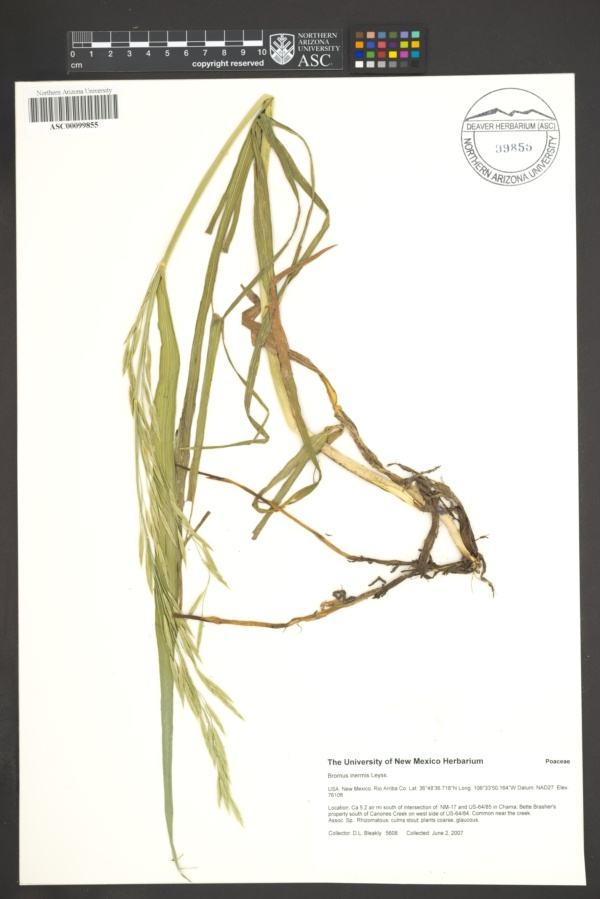
"dwc:specificEpithet": "inermis",
"dwc:county": "Rio Arriba",
"dwc:recordedBy": "D.L. Bleakly",
"dwc:georeferenceSources": "georef batch tool 2019-11-15; GeoLocate",
"dwc:order": "Poales",
"dcterms:references": "https://swbiodiversity.org/seinet/collections/individual/index.php?occid=3426481",
"dwc:scientificNameAuthorship": "Leyss.",
"dwc:occurrenceID": "1ea278f7-1d41-4c9b-bfe8-b8bdd2286cb0",
"dwc:verbatimElevation": "7610ft",
"id": "3426481",
"dwc:taxonID": "1746",
"dwc:stateProvince": "New Mexico",
"dwc:eventDate": "2007-06-02",
"symbiota:recordEnteredBy": "Andra Payne",
"dwc:collectionID": "17a53c97-835b-409e-8a9a-c9a7307a4965",
"dwc:institutionCode": "ASC",
"dwc:country": "United States",
"dwc:georeferenceRemarks": "Point placed south of Canones Creek on W. side of US-64; south of intersection of NM-17. Uncertainty extended to cover area near Canones Creek.",
"dcterms:rightsHolder": "Deaver Herbarium",
"dwc:kingdom": "Plantae",
"dwc:decimalLatitude": "36.809013",
"dwc:occurrenceRemarks": "Common near the creek. With Rhizomatous; culms stout; plants coarse, glaucous.",
"dwc:associatedOccurrences": "herbariumSpecimenDuplicate: https://swbiodiversity.org/seinet/collections/individual/index.php?guid=f0bef873-8f76-46f4-9f53-12ce3ab40bde",
"dwc:basisOfRecord": "PreservedSpecimen",
"dwc:genus": "Bromus",
"dwc:family": "Poaceae",
"dc:rights": "http://creativecommons.org/licenses/by/3.0/",
"symbiota:recordID": "1ea278f7-1d41-4c9b-bfe8-b8bdd2286cb0",
"dwc:phylum": "Magnoliophyta",
"dwc:locality": "Ca 5.2 air mi south of intersection of NM-17 and US-64/85 in Chama; Bette Brasher's property south of Canones Creek on west side of US-64/84.",
"dwc:georeferenceVerificationStatus": "reviewed - medium confidence",
"dwc:geodeticDatum": "WGS84",
"dwc:taxonRank": "Species",
"dwc:higherClassification": "Plantae|Magnoliophyta|Monocots|Commelinids|Poales|Poaceae|Bromus",
"dwc:catalogNumber": "ASC00099855",
"dwc:decimalLongitude": "-106.584861",
"dwc:coordinateUncertaintyInMeters": "1500",
"dwc:georeferencedBy": "ajh486 (2019-11-15 17:22:37)",
"dwc:verbatimEventDate": "6/2/2007",
"dwc:recordNumber": "5608",
"dwc:minimumElevationInMeters": "2319",
"dcterms:modified": "2020-01-17 09:42:32",
"dwc:scientificName": "Bromus inermis"
},
"indexTerms": {
"geopoint": {
"lat": 36.809013,
"lon": -106.584861
},
"family": "poaceae",
"recordset": "b531ea59-025d-4c29-9d23-99ae75bcd55f",
"dqs": 0.42028985507246375,
"stateprovince": "new mexico",
"county": "rio arriba",
"phylum": "magnoliophyta",
"catalognumber": "asc00099855",
"startdayofyear": 153,
"taxonrank": "species",
"specificepithet": "inermis",
"continent": "north america",
"uuid": "dbe31f95-e450-46a6-9fd1-ed0c72f5e2bf",
"countrycode": "usa",
"basisofrecord": "preservedspecimen",
"collector": "d.l. bleakly",
"institutioncode": "asc",
"mediarecords": [
"45c49c23-cca9-433b-8033-e7cec05c0aab"
],
"datecollected": "2007-06-02T00:00:00+00:00",
"etag": "2e17c5d0c40bcbc05175754ac1f1ff1a1f3ef30d",
"recordnumber": "5608",
"minelevation": 2319,
"hasImage": true,
"kingdom": "plantae",
"highertaxon": "plantae|magnoliophyta|monocots|commelinids|poales|poaceae|bromus",
"collectionid": "17a53c97-835b-409e-8a9a-c9a7307a4965",
"taxonid": "1746",
"scientificname": "bromus inermis",
"indexData": {
"dwc:startDayOfYear": "153",
"dwc:specificEpithet": "inermis",
"dwc:county": "Rio Arriba",
"dwc:recordedBy": "D.L. Bleakly",
"idigbio:uuid": "dbe31f95-e450-46a6-9fd1-ed0c72f5e2bf",
"dwc:locality": "Ca 5.2 air mi south of intersection of NM-17 and US-64/85 in Chama; Bette Brasher's property south of Canones Creek on west side of US-64/84.",
"dwc:order": "Poales",
"dcterms:references": "https://swbiodiversity.org/seinet/collections/individual/index.php?occid=3426481",
"dwc:scientificNameAuthorship": "Leyss.",
"idigbio:recordIds": [
"urn:uuid:1ea278f7-1d41-4c9b-bfe8-b8bdd2286cb0",
"b531ea59-025d-4c29-9d23-99ae75bcd55f\\1ea278f7-1d41-4c9b-bfe8-b8bdd2286cb0",
"b531ea59-025d-4c29-9d23-99ae75bcd55f\\3426481"
],
"dwc:occurrenceID": "1ea278f7-1d41-4c9b-bfe8-b8bdd2286cb0",
"id": "3426481",
"dwc:verbatimElevation": "7610ft",
"symbiota:recordEnteredBy": "Andra Payne",
"dwc:taxonID": "1746",
"idigbio:parent": "b531ea59-025d-4c29-9d23-99ae75bcd55f",
"dwc:stateProvince": "New Mexico",
"dwc:eventDate": "2007-06-02",
"dwc:collectionID": "17a53c97-835b-409e-8a9a-c9a7307a4965",
"dwc:country": "United States",
"idigbio:etag": "2e17c5d0c40bcbc05175754ac1f1ff1a1f3ef30d",
"dwc:decimalLatitude": "36.809013",
"dcterms:rightsHolder": "Deaver Herbarium",
"dwc:kingdom": "Plantae",
"dwc:georeferenceRemarks": "Point placed south of Canones Creek on W. side of US-64; south of intersection of NM-17. Uncertainty extended to cover area near Canones Creek.",
"dwc:occurrenceRemarks": "Common near the creek. With Rhizomatous; culms stout; plants coarse, glaucous.",
"dwc:associatedOccurrences": "herbariumSpecimenDuplicate: https://swbiodiversity.org/seinet/collections/individual/index.php?guid=f0bef873-8f76-46f4-9f53-12ce3ab40bde",
"dwc:basisOfRecord": "PreservedSpecimen",
"dwc:genus": "Bromus",
"dwc:continent": "north america",
"dwc:family": "Poaceae",
"dc:rights": "http://creativecommons.org/licenses/by/3.0/",
"dwc:higherClassification": "Plantae|Magnoliophyta|Monocots|Commelinids|Poales|Poaceae|Bromus",
"dwc:geodeticDatum": "WGS84",
"idigbio:siblings": {
"mediarecord": [
"45c49c23-cca9-433b-8033-e7cec05c0aab"
]
},
"symbiota:recordID": "1ea278f7-1d41-4c9b-bfe8-b8bdd2286cb0",
"flag_idigbio_isocountrycode_added": true,
"dwc:phylum": "Magnoliophyta",
"idigbio:dateModified": "2023-01-11T02:45:27.678261",
"dwc:georeferenceSources": "georef batch tool 2019-11-15; GeoLocate",
"dwc:institutionCode": "ASC",
"dwc:taxonRank": "Species",
"dwc:georeferenceVerificationStatus": "reviewed - medium confidence",
"dwc:catalogNumber": "ASC00099855",
"dwc:decimalLongitude": "-106.584861",
"dwc:scientificName": "Bromus inermis",
"dwc:georeferencedBy": "ajh486 (2019-11-15 17:22:37)",
"dwc:verbatimEventDate": "6/2/2007",
"flag_dwc_continent_added": true,
"dwc:recordNumber": "5608",
"idigbio:isocountrycode": "usa",
"flag_taxon_match_failed": true,
"dwc:minimumElevationInMeters": "2319",
"dcterms:modified": "2020-01-17 09:42:32",
"dwc:coordinateUncertaintyInMeters": "1500"
},
"hasMedia": true,
"coordinateuncertainty": 1500,
"datemodified": "2023-01-11T02:45:27.678261+00:00",
"occurrenceid": "1ea278f7-1d41-4c9b-bfe8-b8bdd2286cb0",
"country": "united states",
"locality": "ca 5.2 air mi south of intersection of nm-17 and us-64/85 in chama; bette brasher's property south of canones creek on west side of us-64/84.",
"eventdate": "2007-06-02",
"flags": [
"idigbio_isocountrycode_added",
"dwc_continent_added",
"taxon_match_failed"
],
"verbatimeventdate": "6/2/2007",
"recordids": [
"urn:uuid:1ea278f7-1d41-4c9b-bfe8-b8bdd2286cb0",
"b531ea59-025d-4c29-9d23-99ae75bcd55f\\1ea278f7-1d41-4c9b-bfe8-b8bdd2286cb0",
"b531ea59-025d-4c29-9d23-99ae75bcd55f\\3426481"
],
"genus": "bromus",
"order": "poales"
},
"attribution": {
"totalCount": 121154
}
}