{
"uuid": "cee94041-6a63-42cb-994b-f10e72e793c8",
"type": "records",
"etag": "8d0ebdbbd379f4c26133711f50224b2187728834",
"data": {
"dwc:identificationRemarks": "Former nature_of_id: legacy.",
"dwc:specificEpithet": "ogotorukensis",
"dwc:identificationVerificationStatus": "unknown",
"dwc:kingdom": "Plantae",
"dwc:recordedBy": "Collector(s): Carl Roland, Alan R. Batten",
"dwc:georeferencedDate": "2004-10-18 00:00:00",
"dwc:order": "Asterales",
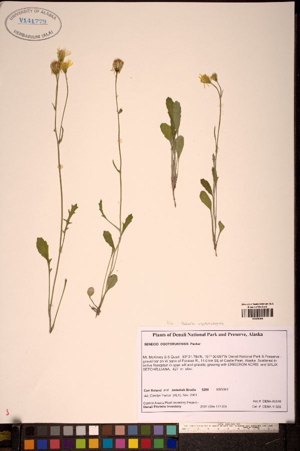
"dwc:habitat": "Scattered in active floodplain in open silt and gravels; growing with ERIGERON ACRIS and SALIX SETCHELLIANA.",
"dcterms:accessRights": "http://vertnet.org/resources/norms.html",
"dwc:occurrenceID": "http://arctos.database.museum/guid/UAM:Herb:56861?seid=454553",
"dwc:dateIdentified": "2004-10-18",
"dwc:verbatimCoordinates": "63.36/-151.84",
"dwc:verbatimEventDate": "2001/08/09",
"id": "http://arctos.database.museum/guid/UAM:Herb:56861?seid=454553",
"dwc:establishmentMeans": "wild",
"dwc:stateProvince": "Alaska",
"dwc:eventDate": "2001-08-09",
"dwc:collectionID": "6",
"dwc:institutionCode": "UAM",
"dwc:country": "United States",
"dwc:collectionCode": "Herb",
"dwc:higherClassification": "Plantae, Tracheophyta, Magnoliopsida, Asterales, Asteraceae, Packera,",
"dwc:decimalLatitude": "63.3600000000",
"dwc:georeferenceVerificationStatus": "unverified",
"dwc:basisOfRecord": "PreservedSpecimen",
"dwc:genus": "Packera",
"dwc:family": "Asteraceae",
"dwc:identificationQualifier": "A",
"dwc:identifiedBy": "Carolyn L. Parker",
"dwc:dynamicProperties": "number of labels=1",
"dwc:georeferenceSources": "unknown",
"dwc:previousIdentifications": "[{\"scientific_name\":\"Packera ogotorukensis\",\"nature_of_id\":\"unknown\",\"accepted_id_fg\":1,\"made_date\":\"2004-10-18\",\"short_citation\":null,\"publication_id\":null,\"identification_remarks\":\"Former nature_of_id: legacy.\",\"idby\":\"Carolyn L. Parker\",\"concept_label\":null}]",
"dwc:organismID": "http://arctos.database.museum/guid/UAM:Herb:56861",
"dwc:phylum": "Tracheophyta",
"dcterms:references": "http://arctos.database.museum/guid/UAM:Herb:56861",
"dwc:locationAccordingTo": "Alan R. Batten",
"dwc:locality": "Alaska Range, Foraker R. 11.6 km SE of Castle Peak, gravel bar on W bank, Mt. McKinley Quad, Denali National Park and Preserve",
"dwc:institutionID": "UAM",
"dwc:associatedMedia": "http://arctos.database.museum/MediaSearch.cfm?collection_object_id=676556",
"dwc:geodeticDatum": "unknown",
"dwc:taxonRank": "species",
"dwc:class": "Magnoliopsida",
"dwc:catalogNumber": "UAM:Herb:56861",
"dwc:nomenclaturalCode": "ICBN",
"dwc:higherGeography": "United States, Alaska",
"dwc:endDayOfYear": "221",
"dwc:decimalLongitude": "-151.8400000000",
"dwc:coordinateUncertaintyInMeters": "3615",
"dwc:month": "08",
"dwc:otherCatalogNumbers": "ALAAC=V141779, other identifier=5280, U. S. National Park Service accession=DENA-00516, U. S. National Park Service catalog=DENA 11356",
"dwc:verbatimLocality": "Alaska Range, Foraker R. 11.6 km SE of Castle Peak, gravel bar on W bank",
"dwc:georeferencedBy": "Alan R. Batten",
"dwc:day": "09",
"dwc:eventTime": "2001-08-09",
"dwc:preparations": "whole organism",
"dwc:verbatimCoordinateSystem": "decimal degrees",
"dwc:georeferenceProtocol": "not recorded",
"dcterms:modified": "2022-10-26 08:35:55.390173",
"dwc:scientificName": "Packera ogotorukensis",
"dwc:footprintWKT": "POLYGON((-151.767756671267 63.3593946382269,-151.769415372537 63.3530785616471,-151.773784646341 63.3470290567875,-151.780695127108 63.3414783623673,-151.789880312167 63.336639442302,-151.800986944802 63.3326978543267,-151.813588630674 63.3298046797911,-151.827202158403 63.3280707771284,-151.841305907246 63.3275625708492,-151.855359659062 63.3282995304598,-151.86882508852 63.3302534314339,-151.881186184868 63.3333494252574,-151.891968860601 63.3374688796244,-151.900759026931 63.3424538850925,-151.907218463277 63.348113262904,-151.911097877746 63.3542298522559,-151.91224664747 63.3605688060194,-151.910618840468 63.3668865836782,-151.906275252333 63.3729403008274,-151.899381338231 63.3784970774676,-151.890201078701 63.3833430237233,-151.879086980571 63.3872915121865,-151.866466574715 63.3901904109694,-151.852825922455 63.3919279901711,-151.838690774008 63.3924372655585,-151.824606127838 63.3916986048624,-151.811115012682 63.3897404915852,-151.798737349711 63.3866384155289,-151.78794974854 63.3825119349672,-151.779167047791 63.3775200290177,-151.772726331458 63.3718549269724,-151.768874041477 63.3657346610942,-151.767756671267 63.3593946382269))",
"dwc:year": "2001"
},
"indexTerms": {
"geopoint": {
"lat": 63.36,
"lon": -151.84
},
"family": "asteraceae",
"recordset": "b6ec6203-09db-4d6e-8cba-ee4bebd2934c",
"dqs": 0.36231884057971014,
"stateprovince": "alaska",
"phylum": "tracheophyta",
"catalognumber": "uam:herb:56861",
"startdayofyear": 221,
"taxonrank": "species",
"specificepithet": "ogotorukensis",
"continent": "north america",
"datemodified": "2022-12-07T00:58:43.563713+00:00",
"uuid": "cee94041-6a63-42cb-994b-f10e72e793c8",
"countrycode": "usa",
"basisofrecord": "preservedspecimen",
"collector": "collector(s): carl roland, alan r. batten",
"institutioncode": "uam",
"mediarecords": [
"3eb6fe1b-7768-491c-848c-cfc3efe67d8c",
"51a60681-9c77-4bab-9da8-ad365201006e"
],
"verbatimlocality": "alaska range, foraker r. 11.6 km se of castle peak, gravel bar on w bank",
"datecollected": "2001-08-09T00:00:00+00:00",
"etag": "8d0ebdbbd379f4c26133711f50224b2187728834",
"hasMedia": true,
"hasImage": true,
"kingdom": "plantae",
"highertaxon": "plantae, tracheophyta, magnoliopsida, asterales, asteraceae, packera,",
"collectionid": "6",
"taxonid": "3114051",
"scientificname": "packera ogotorukensis",
"indexData": {
"dwc:verbatimCoordinates": "63.36/-151.84",
"idigbio:dateModified": "2022-12-07T00:58:43.563713",
"idigbio:uuid": "cee94041-6a63-42cb-994b-f10e72e793c8",
"dwc:georeferencedDate": "2004-10-18 00:00:00",
"gbif:canonicalname": "packera ogotorukensis",
"dwc:habitat": "Scattered in active floodplain in open silt and gravels; growing with ERIGERON ACRIS and SALIX SETCHELLIANA.",
"dwc:occurrenceID": "http://arctos.database.museum/guid/UAM:Herb:56861?seid=454553",
"flag_gbif_genericname_added": true,
"flag_dwc_parentnameusageid_added": true,
"flag_dwc_datasetid_added": true,
"idigbio:parent": "b6ec6203-09db-4d6e-8cba-ee4bebd2934c",
"dwc:country": "United States",
"idigbio:etag": "8d0ebdbbd379f4c26133711f50224b2187728834",
"flag_gbif_vernacularname_added": true,
"dwc:decimalLatitude": "63.3600000000",
"dwc:datasetid": "9ca92552-f23a-41a8-a140-01abaa31c931",
"flag_dwc_continent_added": true,
"dwc:identificationVerificationStatus": "unknown",
"dwc:georeferenceSources": "unknown",
"dwc:preparations": "whole organism",
"flag_idigbio_isocountrycode_added": true,
"dwc:locality": "Alaska Range, Foraker R. 11.6 km SE of Castle Peak, gravel bar on W bank, Mt. McKinley Quad, Denali National Park and Preserve",
"dwc:geodeticDatum": "unknown",
"dwc:taxonRank": "species",
"dwc:higherClassification": "Plantae, Tracheophyta, Magnoliopsida, Asterales, Asteraceae, Packera,",
"dwc:catalogNumber": "UAM:Herb:56861",
"dwc:nomenclaturalCode": "ICBN",
"dwc:higherGeography": "United States, Alaska",
"dwc:decimalLongitude": "-151.8400000000",
"dwc:month": "08",
"dwc:georeferencedBy": "Alan R. Batten",
"dwc:eventTime": "2001-08-09",
"dwc:family": "Asteraceae",
"dwc:verbatimCoordinateSystem": "decimal degrees",
"dwc:coordinateUncertaintyInMeters": "3615",
"dwc:day": "09",
"gbif:vernacularname": [
{
"coreid": "3114051",
"dcterms:language": "en",
"dcterms:source": "database of vascular plants of canada (vascan)",
"dwc:vernacularname": "ogotoruk creek butterweed"
},
{
"coreid": "3114051",
"dcterms:language": "en",
"dcterms:source": "database of vascular plants of canada (vascan)",
"dwc:vernacularname": "ogotoruk creek groundsel"
},
{
"coreid": "3114051",
"dcterms:language": "en",
"dcterms:source": "database of vascular plants of canada (vascan)",
"dwc:vernacularname": "ogotoruk creek ragwort"
},
{
"coreid": "3114051",
"dcterms:language": "en",
"dcterms:source": "integrated taxonomic information system (itis)",
"dwc:vernacularname": "ogotoruk creek ragwort"
},
{
"coreid": "3114051",
"dcterms:language": "fr",
"dcterms:source": "database of vascular plants of canada (vascan)",
"dwc:vernacularname": "séneçon du ruisseau ogotoruk"
}
],
"dwc:identificationRemarks": "Former nature_of_id: legacy.",
"dwc:specificEpithet": "ogotorukensis",
"dwc:kingdom": "Plantae",
"dwc:recordedBy": "Collector(s): Carl Roland, Alan R. Batten",
"dwc:order": "Asterales",
"dcterms:references": "http://arctos.database.museum/guid/UAM:Herb:56861",
"dcterms:accessRights": "http://vertnet.org/resources/norms.html",
"idigbio:recordIds": [
"b6ec6203-09db-4d6e-8cba-ee4bebd2934c\\urn:occurrence:arctos:uam:herb:56861:454553",
"b6ec6203-09db-4d6e-8cba-ee4bebd2934c\\http://arctos.database.museum/guid/uam:herb:56861?seid=454553"
],
"dwc:dateIdentified": "2004-10-18",
"flag_dwc_taxonomicstatus_added": true,
"id": "http://arctos.database.museum/guid/UAM:Herb:56861?seid=454553",
"dwc:establishmentMeans": "wild",
"dwc:stateProvince": "Alaska",
"dwc:eventDate": "2001-08-09",
"dwc:collectionID": "6",
"dwc:collectionCode": "Herb",
"dwc:georeferenceVerificationStatus": "unverified",
"dwc:basisOfRecord": "PreservedSpecimen",
"dwc:taxonomicstatus": "accepted",
"dwc:genus": "Packera",
"dwc:continent": "north america",
"dwc:identificationQualifier": "A",
"dwc:identifiedBy": "Carolyn L. Parker",
"dwc:dynamicProperties": "number of labels=1",
"flag_dwc_taxonid_added": true,
"dwc:previousIdentifications": "[{\"scientific_name\":\"Packera ogotorukensis\",\"nature_of_id\":\"unknown\",\"accepted_id_fg\":1,\"made_date\":\"2004-10-18\",\"short_citation\":null,\"publication_id\":null,\"identification_remarks\":\"Former nature_of_id: legacy.\",\"idby\":\"Carolyn L. Parker\",\"concept_label\":null}]",
"idigbio:siblings": {
"mediarecord": [
"3eb6fe1b-7768-491c-848c-cfc3efe67d8c",
"51a60681-9c77-4bab-9da8-ad365201006e"
]
},
"dwc:organismID": "http://arctos.database.museum/guid/UAM:Herb:56861",
"dwc:phylum": "Tracheophyta",
"gbif:genericname": "packera",
"dwc:locationAccordingTo": "Alan R. Batten",
"dwc:institutionID": "UAM",
"dwc:associatedMedia": "http://arctos.database.museum/MediaSearch.cfm?collection_object_id=676556",
"dwc:institutionCode": "UAM",
"flag_gbif_taxon_corrected": true,
"dwc:parentnameusageid": "8661932",
"dwc:class": "Magnoliopsida",
"dwc:taxonid": "3114051",
"flag_gbif_canonicalname_added": true,
"dwc:endDayOfYear": "221",
"dwc:otherCatalogNumbers": "ALAAC=V141779, other identifier=5280, U. S. National Park Service accession=DENA-00516, U. S. National Park Service catalog=DENA 11356",
"dwc:verbatimLocality": "Alaska Range, Foraker R. 11.6 km SE of Castle Peak, gravel bar on W bank",
"dwc:verbatimEventDate": "2001/08/09",
"idigbio:isocountrycode": "usa",
"dwc:georeferenceProtocol": "not recorded",
"dcterms:modified": "2022-10-26 08:35:55.390173",
"dwc:scientificName": "Packera ogotorukensis",
"dwc:footprintWKT": "POLYGON((-151.767756671267 63.3593946382269,-151.769415372537 63.3530785616471,-151.773784646341 63.3470290567875,-151.780695127108 63.3414783623673,-151.789880312167 63.336639442302,-151.800986944802 63.3326978543267,-151.813588630674 63.3298046797911,-151.827202158403 63.3280707771284,-151.841305907246 63.3275625708492,-151.855359659062 63.3282995304598,-151.86882508852 63.3302534314339,-151.881186184868 63.3333494252574,-151.891968860601 63.3374688796244,-151.900759026931 63.3424538850925,-151.907218463277 63.348113262904,-151.911097877746 63.3542298522559,-151.91224664747 63.3605688060194,-151.910618840468 63.3668865836782,-151.906275252333 63.3729403008274,-151.899381338231 63.3784970774676,-151.890201078701 63.3833430237233,-151.879086980571 63.3872915121865,-151.866466574715 63.3901904109694,-151.852825922455 63.3919279901711,-151.838690774008 63.3924372655585,-151.824606127838 63.3916986048624,-151.811115012682 63.3897404915852,-151.798737349711 63.3866384155289,-151.78794974854 63.3825119349672,-151.779167047791 63.3775200290177,-151.772726331458 63.3718549269724,-151.768874041477 63.3657346610942,-151.767756671267 63.3593946382269))",
"dwc:year": "2001"
},
"coordinateuncertainty": 3615,
"class": "magnoliopsida",
"occurrenceid": "http://arctos.database.museum/guid/uam:herb:56861?seid=454553",
"institutionid": "uam",
"country": "united states",
"locality": "alaska range, foraker r. 11.6 km se of castle peak, gravel bar on w bank, mt. mckinley quad, denali national park and preserve",
"collectioncode": "herb",
"canonicalname": "packera ogotorukensis",
"eventdate": "2001-08-09",
"flags": [
"geopoint_datum_error",
"gbif_genericname_added",
"dwc_parentnameusageid_added",
"dwc_datasetid_added",
"gbif_vernacularname_added",
"dwc_continent_added",
"idigbio_isocountrycode_added",
"dwc_taxonomicstatus_added",
"dwc_taxonid_added",
"gbif_taxon_corrected",
"gbif_canonicalname_added"
],
"verbatimeventdate": "2001/08/09",
"taxonomicstatus": "accepted",
"recordids": [
"b6ec6203-09db-4d6e-8cba-ee4bebd2934c\\urn:occurrence:arctos:uam:herb:56861:454553",
"b6ec6203-09db-4d6e-8cba-ee4bebd2934c\\http://arctos.database.museum/guid/uam:herb:56861?seid=454553"
],
"genus": "packera",
"order": "asterales",
"datasetid": "9ca92552-f23a-41a8-a140-01abaa31c931"
},
"attribution": {
"totalCount": 200630
}
}