{
"uuid": "cac4e1e6-f943-4b5e-bb79-0515c276bae0",
"type": "records",
"etag": "20886fb0292c277b22654b29605dd07e21ec5a05",
"data": {
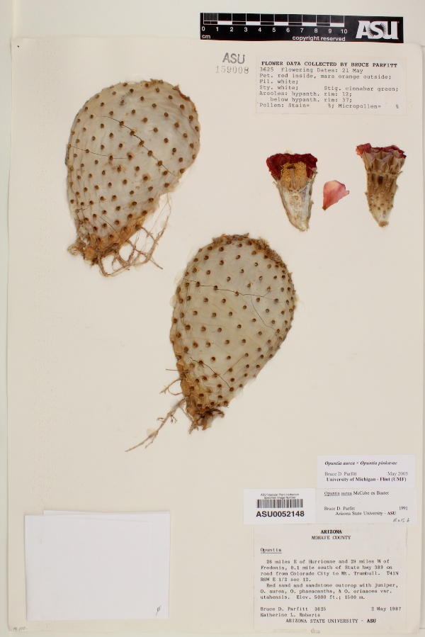
"dwc:startDayOfYear": "122",
"dwc:verbatimCoordinates": "TRS: T41N R6W S12",
"dwc:county": "Mohave County",
"dwc:recordedBy": "Bruce D. Parfitt; Katherine L. Roberts",
"dwc:georeferenceSources": "TRS data - 16 Nov 05",
"dwc:order": "Caryophyllales",
"dwc:habitat": "Red sand and sandstone outcrop",
"dwc:scientificNameAuthorship": "E.M. Baxter",
"dwc:occurrenceID": "654a181b-f58e-4e32-aa0b-a4b5617876a3",
"dwc:verbatimElevation": "5000ft",
"id": "2431119",
"dwc:stateProvince": "Arizona",
"dwc:eventDate": "1987-05-02",
"dwc:collectionID": "a2e32c87-d320-4a01-bafd-a9182ae2e191",
"dwc:country": "USA",
"dwc:collectionCode": "Plants",
"symbiota:recordEnteredBy": "roisan",
"dwc:kingdom": "Plantae",
"dwc:decimalLatitude": "36.9683",
"dwc:occurrenceRemarks": "Flowering date: 21 May; petal red inside, mars orange outside; filament white; style white; stigma cinnabar green; areoles: hypanthium rum 12; below hypantium rim 37",
"dwc:basisOfRecord": "PreservedSpecimen",
"dwc:family": "Cactaceae",
"dc:rights": "http://creativecommons.org/licenses/by-nc/3.0/",
"dwc:identifiedBy": "Bruce D. Parfit, 2005",
"dwc:coordinateUncertaintyInMeters": "700",
"symbiota:recordID": "654a181b-f58e-4e32-aa0b-a4b5617876a3",
"dwc:phylum": "Magnoliophyta",
"dcterms:references": "https://swbiodiversity.org/seinet/collections/individual/index.php?occid=2431119",
"dwc:locality": "26 miles E of Hurricane and 29 miles W of Fredonia; 0.1 miles S of AZ Highway 389 on road from Colorado City to Mt. Trumbull",
"dwc:institutionCode": "ASU",
"dwc:reproductiveCondition": "flowers",
"dwc:higherClassification": "Plantae|Magnoliophyta|Eudicots|Core Eudicots|Caryophyllales",
"dwc:catalogNumber": "ASU0052148",
"dwc:month": "5",
"dwc:decimalLongitude": "-112.899",
"dwc:scientificName": "Opuntia aurea x O. pinkavae",
"dwc:otherCatalogNumbers": "159008",
"dwc:recordNumber": "3625",
"dwc:minimumElevationInMeters": "1524",
"dcterms:modified": "2022-01-03 12:19:20",
"dwc:associatedTaxa": "ecologicallyOccursWith: Juniper|ecologicallyOccursWith: O. aurea|ecologicallyOccursWith: O. phaeacantha|ecologicallyOccursWith: O. erinacea var. utahensis",
"dwc:day": "2",
"dwc:year": "1987"
},
"indexTerms": {
"geopoint": {
"lat": 36.9683,
"lon": -112.899
},
"family": "cactaceae",
"recordset": "40250f4d-7aa6-4fcc-ac38-2868fa4846bd",
"dqs": 0.34782608695652173,
"stateprovince": "arizona",
"county": "mohave county",
"phylum": "magnoliophyta",
"catalognumber": "asu0052148",
"startdayofyear": 122,
"collector": "bruce d. parfitt; katherine l. roberts",
"continent": "north america",
"uuid": "cac4e1e6-f943-4b5e-bb79-0515c276bae0",
"countrycode": "usa",
"basisofrecord": "preservedspecimen",
"institutioncode": "asu",
"mediarecords": [
"6686dc17-ca9f-4323-9342-c5b08426266f"
],
"datecollected": "1987-05-02T00:00:00+00:00",
"etag": "20886fb0292c277b22654b29605dd07e21ec5a05",
"recordnumber": "3625",
"minelevation": 1524,
"hasImage": true,
"kingdom": "plantae",
"highertaxon": "plantae|magnoliophyta|eudicots|core eudicots|caryophyllales",
"collectionid": "a2e32c87-d320-4a01-bafd-a9182ae2e191",
"scientificname": "opuntia aurea x o. pinkavae",
"indexData": {
"dwc:startDayOfYear": "122",
"flag_dwc_country_replaced": true,
"dwc:verbatimCoordinates": "TRS: T41N R6W S12",
"dwc:county": "Mohave County",
"dwc:recordedBy": "Bruce D. Parfitt; Katherine L. Roberts",
"idigbio:uuid": "cac4e1e6-f943-4b5e-bb79-0515c276bae0",
"dwc:locality": "26 miles E of Hurricane and 29 miles W of Fredonia; 0.1 miles S of AZ Highway 389 on road from Colorado City to Mt. Trumbull",
"dwc:order": "Caryophyllales",
"dwc:habitat": "Red sand and sandstone outcrop",
"dwc:scientificNameAuthorship": "E.M. Baxter",
"idigbio:recordIds": [
"urn:uuid:654a181b-f58e-4e32-aa0b-a4b5617876a3",
"40250f4d-7aa6-4fcc-ac38-2868fa4846bd\\2431119",
"40250f4d-7aa6-4fcc-ac38-2868fa4846bd\\urn:uuid:654a181b-f58e-4e32-aa0b-a4b5617876a3",
"40250f4d-7aa6-4fcc-ac38-2868fa4846bd\\654a181b-f58e-4e32-aa0b-a4b5617876a3"
],
"dwc:occurrenceID": "654a181b-f58e-4e32-aa0b-a4b5617876a3",
"dwc:verbatimElevation": "5000ft",
"symbiota:recordEnteredBy": "roisan",
"idigbio:parent": "40250f4d-7aa6-4fcc-ac38-2868fa4846bd",
"dwc:stateProvince": "Arizona",
"dwc:eventDate": "1987-05-02",
"dwc:collectionID": "a2e32c87-d320-4a01-bafd-a9182ae2e191",
"dwc:country": "united states",
"idigbio:etag": "20886fb0292c277b22654b29605dd07e21ec5a05",
"dwc:collectionCode": "Plants",
"id": "2431119",
"dwc:kingdom": "Plantae",
"dwc:decimalLatitude": "36.9683",
"dwc:occurrenceRemarks": "Flowering date: 21 May; petal red inside, mars orange outside; filament white; style white; stigma cinnabar green; areoles: hypanthium rum 12; below hypantium rim 37",
"dwc:basisOfRecord": "PreservedSpecimen",
"dwc:continent": "north america",
"dwc:family": "Cactaceae",
"dc:rights": "http://creativecommons.org/licenses/by-nc/3.0/",
"dwc:identifiedBy": "Bruce D. Parfit, 2005",
"dwc:associatedTaxa": "ecologicallyOccursWith: Juniper|ecologicallyOccursWith: O. aurea|ecologicallyOccursWith: O. phaeacantha|ecologicallyOccursWith: O. erinacea var. utahensis",
"idigbio:siblings": {
"mediarecord": [
"6686dc17-ca9f-4323-9342-c5b08426266f"
]
},
"symbiota:recordID": "654a181b-f58e-4e32-aa0b-a4b5617876a3",
"flag_idigbio_isocountrycode_added": true,
"dwc:phylum": "Magnoliophyta",
"dcterms:references": "https://swbiodiversity.org/seinet/collections/individual/index.php?occid=2431119",
"idigbio:dateModified": "2022-12-06T21:46:35.594653",
"dwc:georeferenceSources": "TRS data - 16 Nov 05",
"dwc:institutionCode": "ASU",
"dwc:reproductiveCondition": "flowers",
"dwc:higherClassification": "Plantae|Magnoliophyta|Eudicots|Core Eudicots|Caryophyllales",
"dwc:catalogNumber": "ASU0052148",
"dwc:month": "5",
"dwc:decimalLongitude": "-112.899",
"dwc:scientificName": "Opuntia aurea x O. pinkavae",
"dwc:otherCatalogNumbers": "159008",
"flag_dwc_continent_added": true,
"dwc:recordNumber": "3625",
"idigbio:isocountrycode": "usa",
"dwc:minimumElevationInMeters": "1524",
"dcterms:modified": "2022-01-03 12:19:20",
"dwc:coordinateUncertaintyInMeters": "700",
"dwc:day": "2",
"dwc:year": "1987"
},
"hasMedia": true,
"coordinateuncertainty": 700,
"datemodified": "2022-12-06T21:46:35.594653+00:00",
"occurrenceid": "654a181b-f58e-4e32-aa0b-a4b5617876a3",
"country": "united states",
"locality": "26 miles e of hurricane and 29 miles w of fredonia; 0.1 miles s of az highway 389 on road from colorado city to mt. trumbull",
"collectioncode": "plants",
"eventdate": "1987-05-02",
"flags": [
"geopoint_datum_missing",
"dwc_country_replaced",
"idigbio_isocountrycode_added",
"dwc_continent_added"
],
"recordids": [
"urn:uuid:654a181b-f58e-4e32-aa0b-a4b5617876a3",
"40250f4d-7aa6-4fcc-ac38-2868fa4846bd\\2431119",
"40250f4d-7aa6-4fcc-ac38-2868fa4846bd\\urn:uuid:654a181b-f58e-4e32-aa0b-a4b5617876a3",
"40250f4d-7aa6-4fcc-ac38-2868fa4846bd\\654a181b-f58e-4e32-aa0b-a4b5617876a3"
],
"order": "caryophyllales"
},
"attribution": {
"totalCount": 283567
}
}