{
"uuid": "a933f4da-4aed-4c94-bf20-891a5def645d",
"type": "records",
"etag": "830bf9a09ce749f31e9db462a0bc84d6b0d288de",
"data": {
"dwc:startDayOfYear": "254",
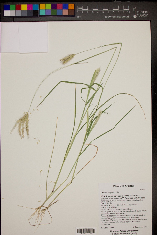
"dwc:specificEpithet": "virgata",
"dwc:county": "Yavapai County",
"dwc:recordedBy": "M. Licher",
"dwc:order": "Poales",
"dwc:habitat": "Acacia constricta dominant Desert Scrub",
"dwc:scientificNameAuthorship": "Sw.",
"dwc:occurrenceID": "d0d755d8-6ee3-4ff4-a50b-7a3f68b74d1e",
"dwc:verbatimCoordinates": "34° 29' 56.1'' N 111° 44' 47.9'' W",
"dwc:verbatimElevation": "3400ft",
"id": "3405952",
"dwc:taxonID": "649",
"dwc:stateProvince": "Arizona",
"dwc:eventDate": "2012-09-10",
"dwc:collectionID": "edb9860c-c481-4d19-88cc-224a536ebcd4",
"dwc:country": "USA",
"symbiota:recordEnteredBy": "lschneberger",
"dwc:kingdom": "Plantae",
"dwc:decimalLatitude": "34.498917",
"dwc:occurrenceRemarks": "Annual grass, 50-75 cm tall, infrequent overall, but in locally abundant patches where found.",
"dwc:associatedOccurrences": "herbariumSpecimenDuplicate: https://swbiodiversity.org/seinet/collections/individual/index.php?guid=33635ffa-3c0c-4539-a106-72e2cc8b853c|herbariumSpecimenDuplicate: https://swbiodiversity.org/seinet/collections/individual/index.php?guid=0ee950e5-3aeb-4de1-a3cd-186ce2e9065c",
"dwc:basisOfRecord": "PreservedSpecimen",
"dwc:genus": "Chloris",
"dwc:family": "Poaceae",
"dc:rights": "http://creativecommons.org/licenses/by-nc/3.0/",
"dwc:coordinateUncertaintyInMeters": "10",
"symbiota:recordID": "d0d755d8-6ee3-4ff4-a50b-7a3f68b74d1e",
"dwc:phylum": "Magnoliophyta",
"dcterms:references": "https://swbiodiversity.org/seinet/collections/individual/index.php?occid=3405952",
"dwc:locality": "Tent Rocks entrance area, along USFS Rd. # 500 just off Fossil Creek Rd. #708, Cottonwood Basin, southeast of Camp Verde.",
"dwc:institutionCode": "DES",
"dwc:taxonRank": "Species",
"dwc:reproductiveCondition": "Flower",
"dwc:higherClassification": "Plantae|Magnoliophyta|Monocots|Commelinids|Poales|Poaceae|Chloris",
"dwc:catalogNumber": "DES00072194",
"dwc:decimalLongitude": "-111.746639",
"dwc:scientificName": "Chloris virgata",
"dwc:recordNumber": "3688",
"dwc:minimumElevationInMeters": "1040",
"dcterms:modified": "2017-03-23 09:37:19",
"dwc:associatedTaxa": "Acacia constricta, Prosopis velutina, Yucca elata, Ambrosia confertiflora, Kallstroemia grandiflora, Hilaria mutica, Amaranthus palmeri, Leptochloa panicea ssp. brachiata, Chloris virgata, Bouteloua aristidoides"
},
"indexTerms": {
"geopoint": {
"lat": 34.498917,
"lon": -111.746639
},
"family": "poaceae",
"recordset": "c569e530-7322-40b8-9b66-1e0ed96fefcb",
"dqs": 0.37681159420289856,
"stateprovince": "arizona",
"county": "yavapai county",
"phylum": "magnoliophyta",
"catalognumber": "des00072194",
"startdayofyear": 254,
"taxonrank": "species",
"specificepithet": "virgata",
"continent": "north america",
"uuid": "a933f4da-4aed-4c94-bf20-891a5def645d",
"countrycode": "usa",
"basisofrecord": "preservedspecimen",
"collector": "m. licher",
"institutioncode": "des",
"mediarecords": [
"8d3a82b1-01f8-43a2-8ff5-e6adf18ffd65"
],
"datecollected": "2012-09-10T00:00:00+00:00",
"etag": "830bf9a09ce749f31e9db462a0bc84d6b0d288de",
"recordnumber": "3688",
"minelevation": 1040,
"hasImage": true,
"kingdom": "plantae",
"highertaxon": "plantae|magnoliophyta|monocots|commelinids|poales|poaceae|chloris",
"collectionid": "edb9860c-c481-4d19-88cc-224a536ebcd4",
"taxonid": "649",
"scientificname": "chloris virgata",
"indexData": {
"dwc:startDayOfYear": "254",
"dwc:specificEpithet": "virgata",
"dwc:county": "Yavapai County",
"dwc:recordedBy": "M. Licher",
"idigbio:uuid": "a933f4da-4aed-4c94-bf20-891a5def645d",
"dwc:order": "Poales",
"dwc:habitat": "Acacia constricta dominant Desert Scrub",
"dwc:scientificNameAuthorship": "Sw.",
"idigbio:recordIds": [
"urn:uuid:d0d755d8-6ee3-4ff4-a50b-7a3f68b74d1e",
"c569e530-7322-40b8-9b66-1e0ed96fefcb\\3405952",
"c569e530-7322-40b8-9b66-1e0ed96fefcb\\urn:uuid:d0d755d8-6ee3-4ff4-a50b-7a3f68b74d1e",
"c569e530-7322-40b8-9b66-1e0ed96fefcb\\d0d755d8-6ee3-4ff4-a50b-7a3f68b74d1e"
],
"dwc:occurrenceID": "d0d755d8-6ee3-4ff4-a50b-7a3f68b74d1e",
"dwc:verbatimCoordinates": "34° 29' 56.1'' N 111° 44' 47.9'' W",
"dwc:verbatimElevation": "3400ft",
"symbiota:recordEnteredBy": "lschneberger",
"dwc:taxonID": "649",
"idigbio:parent": "c569e530-7322-40b8-9b66-1e0ed96fefcb",
"dwc:stateProvince": "Arizona",
"dwc:eventDate": "2012-09-10",
"dwc:collectionID": "edb9860c-c481-4d19-88cc-224a536ebcd4",
"dwc:country": "united states",
"idigbio:etag": "830bf9a09ce749f31e9db462a0bc84d6b0d288de",
"id": "3405952",
"dwc:kingdom": "Plantae",
"dwc:decimalLatitude": "34.498917",
"dwc:occurrenceRemarks": "Annual grass, 50-75 cm tall, infrequent overall, but in locally abundant patches where found.",
"dwc:associatedOccurrences": "herbariumSpecimenDuplicate: https://swbiodiversity.org/seinet/collections/individual/index.php?guid=33635ffa-3c0c-4539-a106-72e2cc8b853c|herbariumSpecimenDuplicate: https://swbiodiversity.org/seinet/collections/individual/index.php?guid=0ee950e5-3aeb-4de1-a3cd-186ce2e9065c",
"dwc:basisOfRecord": "PreservedSpecimen",
"dwc:genus": "Chloris",
"dwc:continent": "north america",
"dwc:family": "Poaceae",
"dc:rights": "http://creativecommons.org/licenses/by-nc/3.0/",
"flag_dwc_country_replaced": true,
"dwc:associatedTaxa": "Acacia constricta, Prosopis velutina, Yucca elata, Ambrosia confertiflora, Kallstroemia grandiflora, Hilaria mutica, Amaranthus palmeri, Leptochloa panicea ssp. brachiata, Chloris virgata, Bouteloua aristidoides",
"idigbio:siblings": {
"mediarecord": [
"8d3a82b1-01f8-43a2-8ff5-e6adf18ffd65"
]
},
"symbiota:recordID": "d0d755d8-6ee3-4ff4-a50b-7a3f68b74d1e",
"flag_idigbio_isocountrycode_added": true,
"dwc:phylum": "Magnoliophyta",
"dcterms:references": "https://swbiodiversity.org/seinet/collections/individual/index.php?occid=3405952",
"idigbio:dateModified": "2023-01-11T03:08:49.189683",
"dwc:locality": "Tent Rocks entrance area, along USFS Rd. # 500 just off Fossil Creek Rd. #708, Cottonwood Basin, southeast of Camp Verde.",
"dwc:institutionCode": "DES",
"dwc:taxonRank": "Species",
"dwc:reproductiveCondition": "Flower",
"dwc:higherClassification": "Plantae|Magnoliophyta|Monocots|Commelinids|Poales|Poaceae|Chloris",
"dwc:catalogNumber": "DES00072194",
"dwc:decimalLongitude": "-111.746639",
"dwc:scientificName": "Chloris virgata",
"flag_dwc_continent_added": true,
"dwc:recordNumber": "3688",
"idigbio:isocountrycode": "usa",
"flag_taxon_match_failed": true,
"dwc:minimumElevationInMeters": "1040",
"dcterms:modified": "2017-03-23 09:37:19",
"dwc:coordinateUncertaintyInMeters": "10"
},
"hasMedia": true,
"coordinateuncertainty": 10,
"datemodified": "2023-01-11T03:08:49.189683+00:00",
"occurrenceid": "d0d755d8-6ee3-4ff4-a50b-7a3f68b74d1e",
"country": "united states",
"locality": "tent rocks entrance area, along usfs rd. # 500 just off fossil creek rd. #708, cottonwood basin, southeast of camp verde.",
"eventdate": "2012-09-10",
"flags": [
"geopoint_datum_missing",
"dwc_country_replaced",
"idigbio_isocountrycode_added",
"dwc_continent_added",
"taxon_match_failed"
],
"recordids": [
"urn:uuid:d0d755d8-6ee3-4ff4-a50b-7a3f68b74d1e",
"c569e530-7322-40b8-9b66-1e0ed96fefcb\\3405952",
"c569e530-7322-40b8-9b66-1e0ed96fefcb\\urn:uuid:d0d755d8-6ee3-4ff4-a50b-7a3f68b74d1e",
"c569e530-7322-40b8-9b66-1e0ed96fefcb\\d0d755d8-6ee3-4ff4-a50b-7a3f68b74d1e"
],
"genus": "chloris",
"order": "poales"
},
"attribution": {
"totalCount": 94693
}
}