{
"uuid": "a032ce9c-a196-45c0-bf1e-28bce3de45cb",
"type": "records",
"etag": "6939a0f21ef5babc988269f989bfa334871a80dc",
"data": {
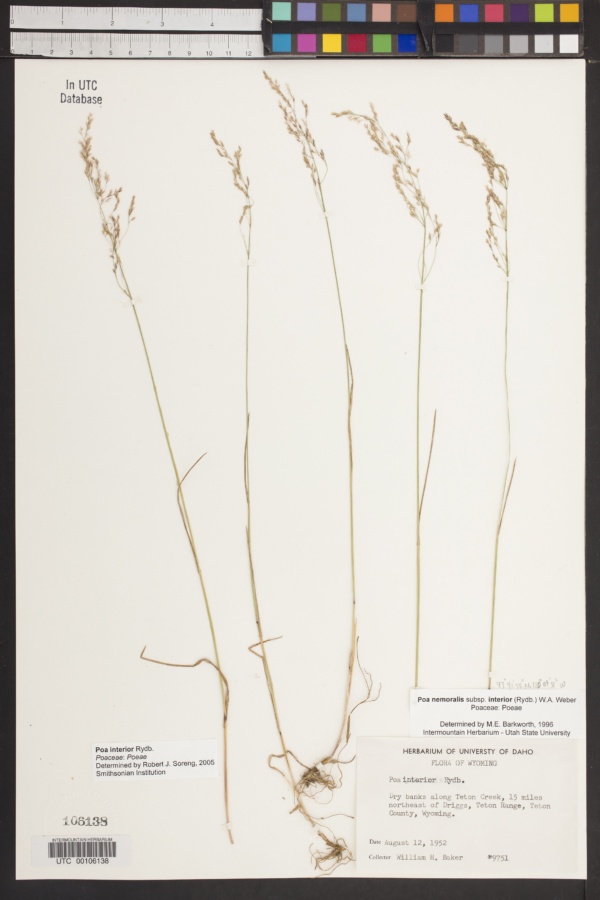
"dwc:startDayOfYear": "225",
"dwc:specificEpithet": "interior",
"dwc:county": "Teton",
"dwc:recordedBy": "William H. Baker",
"dwc:georeferenceSources": "TRS2LL",
"dwc:order": "Poales",
"dwc:habitat": "Dry banks along Teton Creek.",
"dwc:scientificNameAuthorship": "Rydb.",
"dwc:occurrenceID": "USU:UTC:106138",
"id": "203114",
"dwc:taxonID": "15814",
"dwc:stateProvince": "Wyoming",
"dwc:eventDate": "1952-08-12",
"dwc:collectionID": "06bf658d-f555-4c9c-ab93-fc2d7db7086e",
"dwc:country": "United States",
"dwc:collectionCode": "UTC",
"dcterms:rightsHolder": "Utah State University",
"dwc:kingdom": "Plantae",
"dwc:decimalLatitude": "43.6941667",
"dwc:basisOfRecord": "PreservedSpecimen",
"dwc:genus": "Poa",
"dwc:family": "Poaceae",
"dc:rights": "http://creativecommons.org/publicdomain/zero/1.0/",
"symbiota:recordID": "87766d89-9db9-460b-8100-09fff7e3a0f3",
"dwc:phylum": "Magnoliophyta",
"dcterms:references": "https://intermountainbiota.org/portal/collections/individual/index.php?occid=203114",
"dwc:locality": "Teton Range. 15 miles northeast of Driggs dry banks along Teton Creek.",
"dwc:institutionCode": "Utah State University",
"dwc:taxonRank": "Species",
"dwc:reproductiveCondition": "Unknown",
"dwc:higherClassification": "Plantae|Magnoliophyta|Monocots|Commelinids|Poales|Poaceae|Poeae|Poa",
"dwc:catalogNumber": "UTC00106138",
"dwc:month": "8",
"dwc:decimalLongitude": "-110.1641667",
"dwc:recordNumber": "9751",
"dcterms:modified": "2016-11-30 11:49:51",
"dwc:scientificName": "Poa interior",
"dwc:day": "12",
"dwc:year": "1952"
},
"indexTerms": {
"geopoint": {
"lat": 43.6941667,
"lon": -110.1641667
},
"family": "poaceae",
"recordset": "215eeaf0-0a88-409e-a75d-aec98b7c41eb",
"dqs": 0.2463768115942029,
"stateprovince": "wyoming",
"county": "teton",
"phylum": "tracheophyta",
"catalognumber": "utc00106138",
"startdayofyear": 225,
"taxonrank": "species",
"specificepithet": "interior",
"continent": "north america",
"uuid": "a032ce9c-a196-45c0-bf1e-28bce3de45cb",
"countrycode": "usa",
"basisofrecord": "preservedspecimen",
"collector": "william h. baker",
"institutioncode": "utah state university",
"mediarecords": [
"3beb3068-9451-47f1-a964-ea82d013a558"
],
"datemodified": "2022-12-06T21:46:54.888074+00:00",
"datecollected": "1952-08-12T00:00:00+00:00",
"etag": "6939a0f21ef5babc988269f989bfa334871a80dc",
"recordnumber": "9751",
"hasImage": true,
"kingdom": "plantae",
"highertaxon": "plantae|magnoliophyta|monocots|commelinids|poales|poaceae|poeae|poa",
"collectionid": "06bf658d-f555-4c9c-ab93-fc2d7db7086e",
"taxonid": "4120228",
"scientificname": "poa interior",
"indexData": {
"dwc:startDayOfYear": "225",
"dwc:specificEpithet": "interior",
"idigbio:dateModified": "2022-12-06T21:46:54.888074",
"dwc:county": "Teton",
"dwc:recordedBy": "William H. Baker",
"idigbio:uuid": "a032ce9c-a196-45c0-bf1e-28bce3de45cb",
"dwc:locality": "Teton Range. 15 miles northeast of Driggs dry banks along Teton Creek.",
"dwc:order": "Poales",
"dwc:habitat": "Dry banks along Teton Creek.",
"flag_gbif_reference_added": true,
"dwc:scientificNameAuthorship": "rydb.",
"flag_dwc_taxonid_replaced": true,
"dwc:occurrenceID": "USU:UTC:106138",
"flag_dwc_taxonrank_replaced": true,
"flag_dwc_taxonomicstatus_added": true,
"flag_gbif_genericname_added": true,
"dcterms:rightsHolder": "Utah State University",
"dwc:taxonID": "4120228",
"idigbio:parent": "215eeaf0-0a88-409e-a75d-aec98b7c41eb",
"dwc:stateProvince": "Wyoming",
"flag_gbif_taxon_corrected": true,
"dwc:parentnameusageid": "2704173",
"dwc:eventDate": "1952-08-12",
"flag_dwc_scientificnameauthorship_replaced": true,
"dwc:collectionID": "06bf658d-f555-4c9c-ab93-fc2d7db7086e",
"dwc:country": "United States",
"dwc:multimedia": [
{
"dcterms:license": "creative commons attribution share alike 3.0 migrated",
"dcterms:title": "annual meadow-grass (poa annua)",
"dcterms:references": "http://commons.wikimedia.org/wiki/file:poa_annua.jpg",
"coreid": "2704173",
"dcterms:identifier": "http://upload.wikimedia.org/wikipedia/commons/7/77/poa_annua.jpg",
"dcterms:source": "english wikipedia - species pages",
"dcterms:description": "poa annua (straatgras);",
"dcterms:creator": "rasbak",
"dcterms:publisher": "wikimedia commons"
},
{
"dcterms:license": "public domain mark 1.0",
"dcterms:title": "1: einjähriges rispengras (poa annua), links2: zwiebel-rispengras (poa bulbosa), mitte und rechts",
"dcterms:references": "http://commons.wikimedia.org/wiki/file:poa_spp_sturm31.jpg",
"coreid": "2704173",
"dcterms:identifier": "http://upload.wikimedia.org/wikipedia/commons/e/ed/poa_spp_sturm31.jpg",
"dcterms:source": "german wikipedia - species pages",
"dcterms:created": "1796-01-01",
"dcterms:description": "original description 1. einjähriges rispengras, poa annua l. 2. knolliges rispengras, poa bulbosa l.",
"dcterms:creator": "johann georg sturm (painter: jacob sturm)",
"dcterms:publisher": "wikimedia commons"
}
],
"idigbio:etag": "6939a0f21ef5babc988269f989bfa334871a80dc",
"dwc:collectionCode": "UTC",
"flag_dwc_multimedia_added": true,
"id": "203114",
"dwc:kingdom": "Plantae",
"dwc:decimalLatitude": "43.6941667",
"dwc:basisOfRecord": "PreservedSpecimen",
"dwc:taxonomicstatus": "accepted",
"dwc:genus": "Poa",
"dwc:continent": "north america",
"dwc:family": "Poaceae",
"dc:rights": "http://creativecommons.org/publicdomain/zero/1.0/",
"flag_dwc_parentnameusageid_added": true,
"flag_dwc_datasetid_added": true,
"dwc:class": "liliopsida",
"idigbio:isocountrycode": "usa",
"idigbio:siblings": {
"mediarecord": [
"3beb3068-9451-47f1-a964-ea82d013a558"
]
},
"symbiota:recordID": "87766d89-9db9-460b-8100-09fff7e3a0f3",
"flag_idigbio_isocountrycode_added": true,
"gbif:canonicalname": "poa interior",
"dwc:phylum": "tracheophyta",
"dcterms:references": "https://intermountainbiota.org/portal/collections/individual/index.php?occid=203114",
"gbif:genericname": "poa",
"dwc:georeferenceSources": "TRS2LL",
"flag_gbif_vernacularname_added": true,
"dwc:institutionCode": "Utah State University",
"dwc:taxonRank": "species",
"dwc:reproductiveCondition": "Unknown",
"dwc:higherClassification": "Plantae|Magnoliophyta|Monocots|Commelinids|Poales|Poaceae|Poeae|Poa",
"dwc:catalogNumber": "UTC00106138",
"flag_dwc_phylum_replaced": true,
"flag_gbif_canonicalname_added": true,
"dwc:month": "8",
"dwc:decimalLongitude": "-110.1641667",
"gbif:vernacularname": [
{
"coreid": "4120228",
"dcterms:language": "en",
"dcterms:source": "database of vascular plants of canada (vascan)",
"dwc:vernacularname": "inland bluegrass"
},
{
"coreid": "4120228",
"dcterms:language": "en",
"dcterms:source": "grin taxonomy",
"dwc:vernacularname": "inland bluegrass"
},
{
"coreid": "4120228",
"dcterms:source": "integrated taxonomic information system (itis)",
"dwc:vernacularname": "inland bluegrass"
},
{
"coreid": "4120228",
"dcterms:language": "en",
"dcterms:source": "database of vascular plants of canada (vascan)",
"dwc:vernacularname": "interior bluegrass"
},
{
"coreid": "4120228",
"dcterms:language": "fr",
"dcterms:source": "database of vascular plants of canada (vascan)",
"dwc:vernacularname": "pâturin continental"
}
],
"gbif:reference": [
{
"coreid": "4120228",
"dcterms:source": "catalogue of life",
"dcterms:bibliographiccitation": "rydb. (1905) in: bull. torrey bot. club 32: 604"
},
{
"coreid": "4120228",
"dcterms:source": "the plant list with literature",
"dcterms:bibliographiccitation": "rydberg pa (1905) studies on the rocky mountain flora-xv. bulletin of the torrey botanical club 32: 597-610. doi: 10.2307/2478456."
}
],
"flag_dwc_continent_added": true,
"idigbio:recordIds": [
"urn:uuid:87766d89-9db9-460b-8100-09fff7e3a0f3",
"215eeaf0-0a88-409e-a75d-aec98b7c41eb\\usu:utc:106138",
"215eeaf0-0a88-409e-a75d-aec98b7c41eb\\203114",
"215eeaf0-0a88-409e-a75d-aec98b7c41eb\\urn:uuid:87766d89-9db9-460b-8100-09fff7e3a0f3",
"215eeaf0-0a88-409e-a75d-aec98b7c41eb\\87766d89-9db9-460b-8100-09fff7e3a0f3"
],
"dwc:recordNumber": "9751",
"dwc:datasetid": "7ddf754f-d193-4cc9-b351-99906754a03b",
"flag_dwc_class_added": true,
"dcterms:modified": "2016-11-30 11:49:51",
"dwc:scientificName": "Poa interior",
"dwc:day": "12",
"dwc:year": "1952"
},
"hasMedia": true,
"class": "liliopsida",
"occurrenceid": "usu:utc:106138",
"country": "united states",
"locality": "teton range. 15 miles northeast of driggs dry banks along teton creek.",
"collectioncode": "utc",
"canonicalname": "poa interior",
"eventdate": "1952-08-12",
"flags": [
"geopoint_datum_missing",
"gbif_reference_added",
"dwc_taxonid_replaced",
"dwc_taxonrank_replaced",
"dwc_taxonomicstatus_added",
"gbif_genericname_added",
"gbif_taxon_corrected",
"dwc_scientificnameauthorship_replaced",
"dwc_multimedia_added",
"dwc_parentnameusageid_added",
"dwc_datasetid_added",
"idigbio_isocountrycode_added",
"gbif_vernacularname_added",
"dwc_phylum_replaced",
"gbif_canonicalname_added",
"dwc_continent_added",
"dwc_class_added"
],
"taxonomicstatus": "accepted",
"recordids": [
"urn:uuid:87766d89-9db9-460b-8100-09fff7e3a0f3",
"215eeaf0-0a88-409e-a75d-aec98b7c41eb\\usu:utc:106138",
"215eeaf0-0a88-409e-a75d-aec98b7c41eb\\203114",
"215eeaf0-0a88-409e-a75d-aec98b7c41eb\\urn:uuid:87766d89-9db9-460b-8100-09fff7e3a0f3",
"215eeaf0-0a88-409e-a75d-aec98b7c41eb\\87766d89-9db9-460b-8100-09fff7e3a0f3"
],
"genus": "poa",
"order": "poales",
"datasetid": "7ddf754f-d193-4cc9-b351-99906754a03b"
},
"attribution": {
"totalCount": 186686
}
}