{
"uuid": "96d9c864-1eb0-4b7e-9c81-4cf203111110",
"type": "records",
"etag": "6dfd244922a369ac84c5de85e51dfb4d518b7099",
"data": {
"dwc:startDayOfYear": "114",
"dwc:specificEpithet": "filiformis",
"dwc:kingdom": "Plantae",
"dwc:recordedBy": "Marc Baker",
"dwc:georeferenceSources": "georef batch tool 2013-01-04; GeoLocate",
"dwc:order": "Fabales",
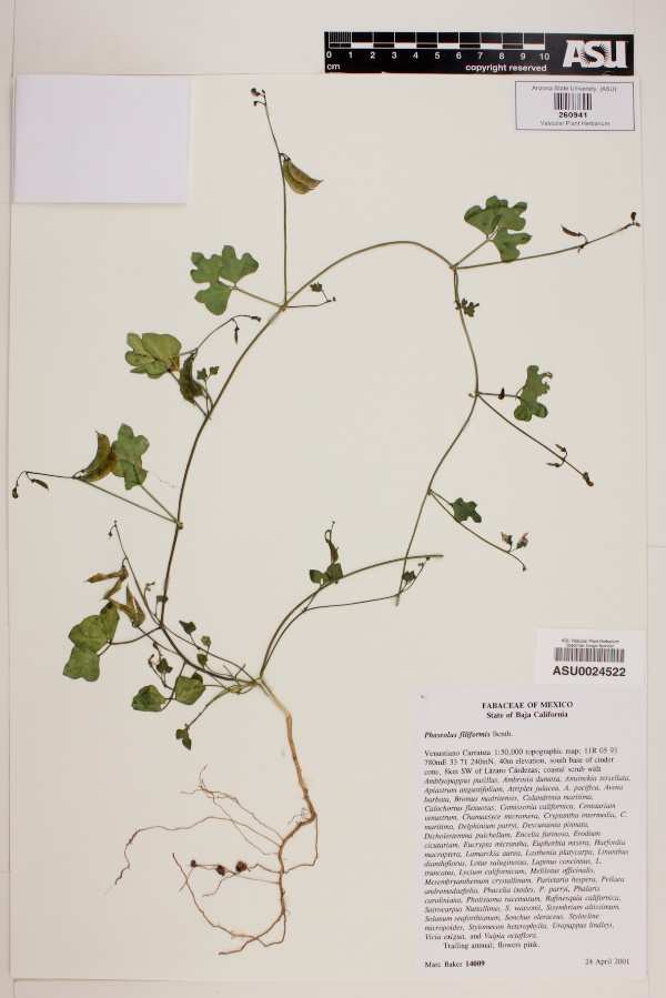
"dwc:habitat": "Coastal scrub.",
"dwc:scientificNameAuthorship": "Benth.",
"dwc:occurrenceID": "bbf5229e-bef7-4382-a59d-620025a59b22",
"id": "1849673",
"dwc:taxonID": "1623",
"dwc:stateProvince": "Baja California",
"dwc:eventDate": "2001-04-24",
"dwc:collectionID": "a2e32c87-d320-4a01-bafd-a9182ae2e191",
"dwc:country": "Mexico",
"dwc:collectionCode": "Plants",
"symbiota:recordEnteredBy": "Katie 2010_08_13",
"dwc:decimalLatitude": "30.520742",
"dwc:occurrenceRemarks": "Trailing annual; flowers pink.",
"dwc:basisOfRecord": "PreservedSpecimen",
"dwc:genus": "Phaseolus",
"dwc:family": "Fabaceae",
"dc:rights": "http://creativecommons.org/licenses/by-nc/3.0/",
"dwc:coordinateUncertaintyInMeters": "20000",
"symbiota:recordID": "bbf5229e-bef7-4382-a59d-620025a59b22",
"dwc:phylum": "Magnoliophyta",
"dcterms:references": "https://swbiodiversity.org/seinet/collections/individual/index.php?occid=1849673",
"dwc:locality": "Venustiano Carranza 1:50,000 topographic map. South base of cinder cone, 8km SW of Lázaro Cárdenas.",
"dwc:georeferenceVerificationStatus": "reviewed - high confidence",
"dwc:institutionCode": "ASU",
"dwc:taxonRank": "Species",
"dwc:higherClassification": "Plantae|Magnoliophyta|Eudicots|Core Eudicots|Fabids|Rosids|Fabales|Fabaceae|Phaseolus",
"dwc:catalogNumber": "ASU0024522",
"dwc:month": "4",
"dwc:decimalLongitude": "-115.927466",
"dwc:scientificName": "Phaseolus filiformis",
"dwc:otherCatalogNumbers": "260941",
"dwc:georeferencedBy": "Velia",
"dwc:recordNumber": "14009",
"dwc:minimumElevationInMeters": "40",
"dcterms:modified": "2022-01-03 12:19:49",
"dwc:associatedTaxa": "ecologicallyOccursWith: Amblyopappus pusillus|ecologicallyOccursWith: Ambrosia dumosa|ecologicallyOccursWith: Amsinckia tessellata|ecologicallyOccursWith: Apiastrum angustifolium|ecologicallyOccursWith: Atriplex Julacea|ecologicallyOccursWith: A. pacifica|ecologicallyOccursWith: Avena barbata|ecologicallyOccursWith: Bromus madritensis|ecologicallyOccursWith: Calandrinia marítima|ecologicallyOccursWith: Calochortus flexuosus|ecologicallyOccursWith: Camissonia califomica|ecologicallyOccursWith: Centauríum venustrum|ecologicallyOccursWith: Chamaesyce micromera|ecologicallyOccursWith: Cryptantha intermedia|ecologicallyOccursWith: C. marítima|ecologicallyOccursWith: Delphinium parryi|ecologicallyOccursWith: Descurainia pinnata|ecologicallyOccursWith: Dicholestemma pulchellum|ecologicallyOccursWith: Encelia farínosa|ecologicallyOccursWith: Erodium cicutaríum|ecologicallyOccursWith: Eucrypta micrantha. Euphorbia misera|ecologicallyOccursWith: Harfordia macroptera|ecologicallyOccursWith: LamarcJda aurea|ecologicallyOccursWith: Lasthenia platycarpa|ecologicallyOccursWith: Linanthus dianthiflorus|ecologicallyOccursWith: Lotus saluginosus|ecologicallyOccursWith: Lupinus concinnus|ecologicallyOccursWith: L. truncatus|ecologicallyOccursWith: Lycium califomicum|ecologicallyOccursWith: Melilotus officinalis|ecologicallyOccursWith: Mesembryanthemum crystallinum|ecologicallyOccursWith: Paríetaría hespera|ecologicallyOccursWith: Pellaea andromedaolia|ecologicallyOccursWith: Phacelia Ixodes|ecologicallyOccursWith: P. parryi|ecologicallyOccursWith: Phalarís caroliniana|ecologicallyOccursWith: Pholistoma racemosum|ecologicallyOccursWith: Rafinesquia califomica|ecologicallyOccursWith: Sairocarpus Nuttallinus|ecologicallyOccursWith: S. watsonii|ecologicallyOccursWith: Sisymbríum altissimum|ecologicallyOccursWith: Solanum seaforthianum|ecologicallyOccursWith: Sonchus oleraceus|ecologicallyOccursWith: Stylocline micropoides|ecologicallyOccursWith: Stylomecon heterophylla|ecologicallyOccursWith: Uropappus lindleyi. Vicia exigua|ecologicallyOccursWith: Vulpia octoflora",
"dwc:day": "24",
"dwc:year": "2001"
},
"indexTerms": {
"geopoint": {
"lat": 30.520742,
"lon": -115.927466
},
"family": "fabaceae",
"recordset": "40250f4d-7aa6-4fcc-ac38-2868fa4846bd",
"dqs": 0.2753623188405797,
"stateprovince": "baja california",
"phylum": "tracheophyta",
"catalognumber": "asu0024522",
"startdayofyear": 114,
"taxonrank": "species",
"specificepithet": "filiformis",
"continent": "north america",
"uuid": "96d9c864-1eb0-4b7e-9c81-4cf203111110",
"countrycode": "mex",
"basisofrecord": "preservedspecimen",
"collector": "marc baker",
"institutioncode": "asu",
"mediarecords": [
"bd67dc74-4601-4525-b3b8-f9712208ef41"
],
"datemodified": "2022-12-06T21:46:35.594653+00:00",
"datecollected": "2001-04-24T00:00:00+00:00",
"etag": "6dfd244922a369ac84c5de85e51dfb4d518b7099",
"recordnumber": "14009",
"minelevation": 40,
"hasImage": true,
"kingdom": "plantae",
"highertaxon": "plantae|magnoliophyta|eudicots|core eudicots|fabids|rosids|fabales|fabaceae|phaseolus",
"collectionid": "a2e32c87-d320-4a01-bafd-a9182ae2e191",
"taxonid": "5350508",
"scientificname": "phaseolus filiformis",
"indexData": {
"dwc:startDayOfYear": "114",
"dwc:specificEpithet": "filiformis",
"idigbio:dateModified": "2022-12-06T21:46:35.594653",
"dwc:kingdom": "Plantae",
"dwc:recordedBy": "Marc Baker",
"idigbio:uuid": "96d9c864-1eb0-4b7e-9c81-4cf203111110",
"dwc:locality": "Venustiano Carranza 1:50,000 topographic map. South base of cinder cone, 8km SW of Lázaro Cárdenas.",
"dwc:order": "Fabales",
"dwc:habitat": "Coastal scrub.",
"dwc:scientificNameAuthorship": "benth.",
"flag_dwc_taxonid_replaced": true,
"dwc:occurrenceID": "bbf5229e-bef7-4382-a59d-620025a59b22",
"flag_dwc_taxonrank_replaced": true,
"gbif:vernacularname": [
{
"coreid": "5350508",
"dcterms:language": "en",
"dcterms:source": "integrated taxonomic information system (itis)",
"dwc:vernacularname": "slimjim bean"
}
],
"flag_dwc_taxonomicstatus_added": true,
"flag_gbif_genericname_added": true,
"symbiota:recordEnteredBy": "Katie 2010_08_13",
"dwc:taxonID": "5350508",
"idigbio:parent": "40250f4d-7aa6-4fcc-ac38-2868fa4846bd",
"dwc:stateProvince": "Baja California",
"flag_gbif_taxon_corrected": true,
"dwc:eventDate": "2001-04-24",
"flag_dwc_scientificnameauthorship_replaced": true,
"dwc:collectionID": "a2e32c87-d320-4a01-bafd-a9182ae2e191",
"dwc:country": "Mexico",
"dwc:multimedia": [
{
"dcterms:license": "gnu free documentation license",
"dcterms:title": "kulturform der gartenbohne (phaseolus vulgaris).",
"dcterms:references": "http://commons.wikimedia.org/wiki/file:haricots_grimpants_phénomènes02.jpg",
"coreid": "2947798",
"dcterms:identifier": "http://upload.wikimedia.org/wikipedia/commons/4/48/haricots_grimpants_ph%c3%a9nom%c3%a8nes02.jpg",
"dcterms:source": "german wikipedia - species pages",
"dcterms:description": "haricots grimpants variété phénomène (phaseolus vulgaris)",
"dcterms:creator": "spedona",
"dcterms:publisher": "wikimedia commons"
},
{
"dcterms:license": "creative commons attribution share alike 3.0 migrated",
"dcterms:title": "p. vulgaris",
"dcterms:references": "http://commons.wikimedia.org/wiki/file:snijboonplanten_phaseolus_vulgaris.jpg",
"coreid": "2947798",
"dcterms:identifier": "http://upload.wikimedia.org/wikipedia/commons/7/79/snijboonplanten_phaseolus_vulgaris.jpg",
"dcterms:source": "english wikipedia - species pages",
"dcterms:description": "nederlands: snijboon planten english: phaseolus vulgaris",
"dcterms:creator": "rasbak",
"dcterms:publisher": "wikimedia commons"
}
],
"idigbio:etag": "6dfd244922a369ac84c5de85e51dfb4d518b7099",
"dwc:collectionCode": "Plants",
"flag_dwc_multimedia_added": true,
"id": "1849673",
"dwc:decimalLatitude": "30.520742",
"dwc:occurrenceRemarks": "Trailing annual; flowers pink.",
"dwc:basisOfRecord": "PreservedSpecimen",
"dwc:taxonomicstatus": "accepted",
"dwc:genus": "Phaseolus",
"dwc:continent": "north america",
"dwc:family": "Fabaceae",
"dc:rights": "http://creativecommons.org/licenses/by-nc/3.0/",
"flag_dwc_parentnameusageid_added": true,
"flag_dwc_datasetid_added": true,
"dwc:class": "magnoliopsida",
"dwc:associatedTaxa": "ecologicallyOccursWith: Amblyopappus pusillus|ecologicallyOccursWith: Ambrosia dumosa|ecologicallyOccursWith: Amsinckia tessellata|ecologicallyOccursWith: Apiastrum angustifolium|ecologicallyOccursWith: Atriplex Julacea|ecologicallyOccursWith: A. pacifica|ecologicallyOccursWith: Avena barbata|ecologicallyOccursWith: Bromus madritensis|ecologicallyOccursWith: Calandrinia marítima|ecologicallyOccursWith: Calochortus flexuosus|ecologicallyOccursWith: Camissonia califomica|ecologicallyOccursWith: Centauríum venustrum|ecologicallyOccursWith: Chamaesyce micromera|ecologicallyOccursWith: Cryptantha intermedia|ecologicallyOccursWith: C. marítima|ecologicallyOccursWith: Delphinium parryi|ecologicallyOccursWith: Descurainia pinnata|ecologicallyOccursWith: Dicholestemma pulchellum|ecologicallyOccursWith: Encelia farínosa|ecologicallyOccursWith: Erodium cicutaríum|ecologicallyOccursWith: Eucrypta micrantha. Euphorbia misera|ecologicallyOccursWith: Harfordia macroptera|ecologicallyOccursWith: LamarcJda aurea|ecologicallyOccursWith: Lasthenia platycarpa|ecologicallyOccursWith: Linanthus dianthiflorus|ecologicallyOccursWith: Lotus saluginosus|ecologicallyOccursWith: Lupinus concinnus|ecologicallyOccursWith: L. truncatus|ecologicallyOccursWith: Lycium califomicum|ecologicallyOccursWith: Melilotus officinalis|ecologicallyOccursWith: Mesembryanthemum crystallinum|ecologicallyOccursWith: Paríetaría hespera|ecologicallyOccursWith: Pellaea andromedaolia|ecologicallyOccursWith: Phacelia Ixodes|ecologicallyOccursWith: P. parryi|ecologicallyOccursWith: Phalarís caroliniana|ecologicallyOccursWith: Pholistoma racemosum|ecologicallyOccursWith: Rafinesquia califomica|ecologicallyOccursWith: Sairocarpus Nuttallinus|ecologicallyOccursWith: S. watsonii|ecologicallyOccursWith: Sisymbríum altissimum|ecologicallyOccursWith: Solanum seaforthianum|ecologicallyOccursWith: Sonchus oleraceus|ecologicallyOccursWith: Stylocline micropoides|ecologicallyOccursWith: Stylomecon heterophylla|ecologicallyOccursWith: Uropappus lindleyi. Vicia exigua|ecologicallyOccursWith: Vulpia octoflora",
"dwc:higherClassification": "Plantae|Magnoliophyta|Eudicots|Core Eudicots|Fabids|Rosids|Fabales|Fabaceae|Phaseolus",
"idigbio:isocountrycode": "mex",
"idigbio:siblings": {
"mediarecord": [
"bd67dc74-4601-4525-b3b8-f9712208ef41"
]
},
"symbiota:recordID": "bbf5229e-bef7-4382-a59d-620025a59b22",
"flag_idigbio_isocountrycode_added": true,
"gbif:canonicalname": "phaseolus filiformis",
"dwc:phylum": "tracheophyta",
"dcterms:references": "https://swbiodiversity.org/seinet/collections/individual/index.php?occid=1849673",
"gbif:genericname": "phaseolus",
"dwc:georeferenceSources": "georef batch tool 2013-01-04; GeoLocate",
"flag_gbif_vernacularname_added": true,
"dwc:institutionCode": "ASU",
"dwc:taxonRank": "species",
"dwc:parentnameusageid": "2947798",
"dwc:georeferenceVerificationStatus": "reviewed - high confidence",
"dwc:catalogNumber": "ASU0024522",
"flag_dwc_phylum_replaced": true,
"flag_gbif_canonicalname_added": true,
"dwc:month": "4",
"dwc:decimalLongitude": "-115.927466",
"dwc:scientificName": "Phaseolus filiformis",
"dwc:otherCatalogNumbers": "260941",
"dwc:georeferencedBy": "Velia",
"flag_dwc_continent_added": true,
"idigbio:recordIds": [
"urn:uuid:bbf5229e-bef7-4382-a59d-620025a59b22",
"40250f4d-7aa6-4fcc-ac38-2868fa4846bd\\urn:uuid:bbf5229e-bef7-4382-a59d-620025a59b22",
"40250f4d-7aa6-4fcc-ac38-2868fa4846bd\\1849673",
"40250f4d-7aa6-4fcc-ac38-2868fa4846bd\\bbf5229e-bef7-4382-a59d-620025a59b22"
],
"dwc:recordNumber": "14009",
"dwc:datasetid": "7ddf754f-d193-4cc9-b351-99906754a03b",
"flag_dwc_class_added": true,
"dwc:minimumElevationInMeters": "40",
"dcterms:modified": "2022-01-03 12:19:49",
"dwc:coordinateUncertaintyInMeters": "20000",
"dwc:day": "24",
"dwc:year": "2001"
},
"hasMedia": true,
"coordinateuncertainty": 20000,
"class": "magnoliopsida",
"occurrenceid": "bbf5229e-bef7-4382-a59d-620025a59b22",
"country": "mexico",
"locality": "venustiano carranza 1:50,000 topographic map. south base of cinder cone, 8km sw of lázaro cárdenas.",
"collectioncode": "plants",
"canonicalname": "phaseolus filiformis",
"eventdate": "2001-04-24",
"flags": [
"geopoint_datum_missing",
"dwc_taxonid_replaced",
"dwc_taxonrank_replaced",
"dwc_taxonomicstatus_added",
"gbif_genericname_added",
"gbif_taxon_corrected",
"dwc_scientificnameauthorship_replaced",
"dwc_multimedia_added",
"dwc_parentnameusageid_added",
"dwc_datasetid_added",
"idigbio_isocountrycode_added",
"gbif_vernacularname_added",
"dwc_phylum_replaced",
"gbif_canonicalname_added",
"dwc_continent_added",
"dwc_class_added"
],
"taxonomicstatus": "accepted",
"recordids": [
"urn:uuid:bbf5229e-bef7-4382-a59d-620025a59b22",
"40250f4d-7aa6-4fcc-ac38-2868fa4846bd\\urn:uuid:bbf5229e-bef7-4382-a59d-620025a59b22",
"40250f4d-7aa6-4fcc-ac38-2868fa4846bd\\1849673",
"40250f4d-7aa6-4fcc-ac38-2868fa4846bd\\bbf5229e-bef7-4382-a59d-620025a59b22"
],
"genus": "phaseolus",
"order": "fabales",
"datasetid": "7ddf754f-d193-4cc9-b351-99906754a03b"
},
"attribution": {
"totalCount": 283567
}
}