{
"uuid": "959c1b97-a8ac-42c4-af69-0672da2df91a",
"type": "records",
"etag": "26129afc47f46212d6960a1cc0ac508824fcd945",
"data": {
"dwc:startDayOfYear": "293",
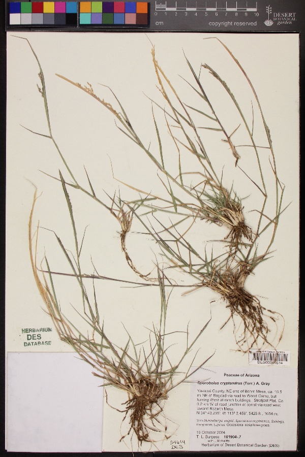
"dwc:specificEpithet": "cryptandrus",
"dwc:county": "Yavapai County",
"dwc:recordedBy": "T. L. Burgess; J.McAuliffe",
"dwc:order": "Poales",
"dcterms:references": "https://swbiodiversity.org/seinet/collections/individual/index.php?occid=2047807",
"dwc:scientificNameAuthorship": "(Torr.) A. Gray",
"dwc:occurrenceID": "a3d47e52-89d2-4674-9fc6-6a4b5c91194c",
"dwc:verbatimCoordinates": "34d 43.295m N; 113d 3.459m W",
"dwc:verbatimElevation": "5425ft.",
"id": "2047807",
"dwc:taxonID": "3214",
"dwc:stateProvince": "Arizona",
"dwc:eventDate": "2004-10-19",
"dwc:collectionID": "edb9860c-c481-4d19-88cc-224a536ebcd4",
"dwc:country": "USA",
"symbiota:recordEnteredBy": "Dixie",
"dwc:kingdom": "Plantae",
"dwc:decimalLatitude": "34.721583",
"dwc:occurrenceRemarks": "Occasional caespitose grass.",
"dwc:basisOfRecord": "PreservedSpecimen",
"dwc:genus": "Sporobolus",
"dwc:family": "Poaceae",
"dc:rights": "http://creativecommons.org/licenses/by-nc/3.0/",
"symbiota:recordID": "a3d47e52-89d2-4674-9fc6-6a4b5c91194c",
"dwc:phylum": "Magnoliophyta",
"dwc:locality": "NE end of Behm Mesa, ca. 15.5 mi NE of Bagdad via road to Wood Camp, but turning West at ranch buildings. Strotjost Flat. Ca. 0.2 km W of road junction at corral via road west toward Bozarth Mesa.",
"dwc:institutionCode": "DES",
"dwc:taxonRank": "Species",
"dwc:reproductiveCondition": "flowers & fruit",
"dwc:higherClassification": "Plantae|Magnoliophyta|Monocots|Commelinids|Poales|Poaceae|Sporobolus",
"dwc:catalogNumber": "DES00054614",
"dwc:month": "10",
"dwc:decimalLongitude": "-113.05765",
"dwc:scientificName": "Sporobolus cryptandrus",
"dwc:recordNumber": "101904.7",
"dwc:minimumElevationInMeters": "1654",
"dcterms:modified": "2015-01-06 12:31:47",
"dwc:associatedTaxa": "Muhlenbergia wrightii, Sporobolus cryptandrus, Solidago, Eriogonum, Lupinus",
"dwc:day": "19",
"dwc:year": "2004"
},
"indexTerms": {
"geopoint": {
"lat": 34.721583,
"lon": -113.05765
},
"family": "poaceae",
"recordset": "c569e530-7322-40b8-9b66-1e0ed96fefcb",
"dqs": 0.2318840579710145,
"stateprovince": "arizona",
"county": "yavapai county",
"phylum": "tracheophyta",
"catalognumber": "des00054614",
"startdayofyear": 293,
"taxonrank": "species",
"specificepithet": "cryptandrus",
"continent": "north america",
"uuid": "959c1b97-a8ac-42c4-af69-0672da2df91a",
"countrycode": "usa",
"basisofrecord": "preservedspecimen",
"collector": "t. l. burgess; j.mcauliffe",
"institutioncode": "des",
"mediarecords": [
"236dd6be-cb1c-47dd-96a9-eac58750475f"
],
"datemodified": "2022-12-06T22:03:37.426550+00:00",
"datecollected": "2004-10-19T00:00:00+00:00",
"etag": "26129afc47f46212d6960a1cc0ac508824fcd945",
"recordnumber": "101904.7",
"minelevation": 1654,
"hasImage": true,
"kingdom": "plantae",
"highertaxon": "plantae|magnoliophyta|monocots|commelinids|poales|poaceae|sporobolus",
"collectionid": "edb9860c-c481-4d19-88cc-224a536ebcd4",
"taxonid": "2704769",
"scientificname": "sporobolus cryptandrus",
"indexData": {
"dwc:startDayOfYear": "293",
"flag_dwc_country_replaced": true,
"dwc:specificEpithet": "cryptandrus",
"idigbio:dateModified": "2022-12-06T22:03:37.426550",
"dwc:county": "Yavapai County",
"dwc:recordedBy": "T. L. Burgess; J.McAuliffe",
"idigbio:uuid": "959c1b97-a8ac-42c4-af69-0672da2df91a",
"flag_dwc_multimedia_added": true,
"dwc:order": "Poales",
"dcterms:references": "https://swbiodiversity.org/seinet/collections/individual/index.php?occid=2047807",
"flag_gbif_reference_added": true,
"dwc:scientificNameAuthorship": "a.gray (torr.)",
"flag_dwc_taxonid_replaced": true,
"dwc:occurrenceID": "a3d47e52-89d2-4674-9fc6-6a4b5c91194c",
"gbif:vernacularname": [
{
"coreid": "2704769",
"dcterms:language": "en",
"dcterms:source": "grin taxonomy",
"dwc:vernacularname": "prairie grass"
},
{
"coreid": "2704769",
"dcterms:language": "en",
"dcterms:source": "database of vascular plants of canada (vascan)",
"dwc:vernacularname": "sand dropseed"
},
{
"coreid": "2704769",
"dcterms:language": "en",
"dcterms:source": "grin taxonomy",
"dwc:vernacularname": "sand dropseed"
},
{
"coreid": "2704769",
"dcterms:language": "en",
"dcterms:source": "integrated taxonomic information system (itis)",
"dwc:vernacularname": "sand dropseed"
},
{
"coreid": "2704769",
"dcterms:language": "fr",
"dcterms:source": "database of vascular plants of canada (vascan)",
"dwc:vernacularname": "sporobole à fleurs cachées"
},
{
"coreid": "2704769",
"dcterms:language": "fr",
"dcterms:source": "grin taxonomy",
"dwc:vernacularname": "sporobole à fleurs cacnées"
},
{
"dwc:countrycode": "de",
"dwc:country": "germany",
"dwc:vernacularname": "verstecktblütiger fallsame",
"coreid": "2704769",
"dcterms:source": "taxon list of vascular plants from bavaria, germany compiled in the context of the bfl project",
"dcterms:language": "de"
}
],
"dwc:verbatimCoordinates": "34d 43.295m N; 113d 3.459m W",
"dwc:verbatimElevation": "5425ft.",
"flag_dwc_taxonomicstatus_added": true,
"flag_gbif_genericname_added": true,
"symbiota:recordEnteredBy": "Dixie",
"dwc:taxonID": "2704769",
"idigbio:parent": "c569e530-7322-40b8-9b66-1e0ed96fefcb",
"dwc:stateProvince": "Arizona",
"flag_gbif_taxon_corrected": true,
"dwc:parentnameusageid": "2704744",
"dwc:eventDate": "2004-10-19",
"flag_dwc_scientificnameauthorship_replaced": true,
"dwc:collectionID": "edb9860c-c481-4d19-88cc-224a536ebcd4",
"dwc:country": "united states",
"dwc:multimedia": [
{
"dcterms:license": "creative commons attribution share alike",
"dcterms:references": "http://commons.wikimedia.org/wiki/file:sporoboluscryptandrus.jpg",
"coreid": "2704769",
"dcterms:identifier": "http://upload.wikimedia.org/wikipedia/commons/2/23/sporoboluscryptandrus.jpg",
"dcterms:source": "english wikipedia - species pages",
"dcterms:description": "english: sporobolus cryptandrus at roadside in alzada, montana, usa. a common road side grass especially where sandy, gravelly, or otherwise well drained, \"sporobolus cryptandrus often harbors its inflorescence within a curved leaf sheath. the similar direction of the inflorescence arcs render this species very conspicous even at at high speed from inside a car.\"",
"dcterms:creator": "matt lavin",
"dcterms:publisher": "wikimedia commons"
}
],
"idigbio:etag": "26129afc47f46212d6960a1cc0ac508824fcd945",
"id": "2047807",
"dwc:kingdom": "Plantae",
"dwc:decimalLatitude": "34.721583",
"dwc:occurrenceRemarks": "Occasional caespitose grass.",
"dwc:basisOfRecord": "PreservedSpecimen",
"dwc:taxonomicstatus": "accepted",
"dwc:genus": "Sporobolus",
"dwc:continent": "north america",
"dwc:family": "Poaceae",
"dc:rights": "http://creativecommons.org/licenses/by-nc/3.0/",
"flag_dwc_parentnameusageid_added": true,
"flag_dwc_datasetid_added": true,
"dwc:class": "liliopsida",
"idigbio:isocountrycode": "usa",
"idigbio:siblings": {
"mediarecord": [
"236dd6be-cb1c-47dd-96a9-eac58750475f"
]
},
"symbiota:recordID": "a3d47e52-89d2-4674-9fc6-6a4b5c91194c",
"flag_idigbio_isocountrycode_added": true,
"gbif:canonicalname": "sporobolus cryptandrus",
"dwc:phylum": "tracheophyta",
"gbif:genericname": "sporobolus",
"dwc:locality": "NE end of Behm Mesa, ca. 15.5 mi NE of Bagdad via road to Wood Camp, but turning West at ranch buildings. Strotjost Flat. Ca. 0.2 km W of road junction at corral via road west toward Bozarth Mesa.",
"flag_gbif_vernacularname_added": true,
"dwc:institutionCode": "DES",
"dwc:taxonRank": "Species",
"dwc:reproductiveCondition": "flowers & fruit",
"dwc:higherClassification": "Plantae|Magnoliophyta|Monocots|Commelinids|Poales|Poaceae|Sporobolus",
"dwc:catalogNumber": "DES00054614",
"flag_dwc_phylum_replaced": true,
"flag_gbif_canonicalname_added": true,
"dwc:month": "10",
"dwc:decimalLongitude": "-113.05765",
"dwc:associatedTaxa": "Muhlenbergia wrightii, Sporobolus cryptandrus, Solidago, Eriogonum, Lupinus",
"flag_dwc_continent_added": true,
"gbif:reference": [
{
"coreid": "2704769",
"dcterms:source": "catalogue of life",
"dcterms:bibliographiccitation": "a.gray (1848) in: manual: 576"
}
],
"dwc:originalnameusageid": "2704771",
"idigbio:recordIds": [
"urn:uuid:a3d47e52-89d2-4674-9fc6-6a4b5c91194c",
"c569e530-7322-40b8-9b66-1e0ed96fefcb\\2047807",
"c569e530-7322-40b8-9b66-1e0ed96fefcb\\urn:uuid:a3d47e52-89d2-4674-9fc6-6a4b5c91194c",
"c569e530-7322-40b8-9b66-1e0ed96fefcb\\a3d47e52-89d2-4674-9fc6-6a4b5c91194c"
],
"dwc:recordNumber": "101904.7",
"dwc:datasetid": "7ddf754f-d193-4cc9-b351-99906754a03b",
"flag_dwc_originalnameusageid_added": true,
"flag_dwc_class_added": true,
"dwc:minimumElevationInMeters": "1654",
"dcterms:modified": "2015-01-06 12:31:47",
"dwc:scientificName": "Sporobolus cryptandrus",
"dwc:day": "19",
"dwc:year": "2004"
},
"hasMedia": true,
"class": "liliopsida",
"occurrenceid": "a3d47e52-89d2-4674-9fc6-6a4b5c91194c",
"country": "united states",
"locality": "ne end of behm mesa, ca. 15.5 mi ne of bagdad via road to wood camp, but turning west at ranch buildings. strotjost flat. ca. 0.2 km w of road junction at corral via road west toward bozarth mesa.",
"canonicalname": "sporobolus cryptandrus",
"eventdate": "2004-10-19",
"flags": [
"geopoint_datum_missing",
"dwc_country_replaced",
"dwc_multimedia_added",
"gbif_reference_added",
"dwc_taxonid_replaced",
"dwc_taxonomicstatus_added",
"gbif_genericname_added",
"gbif_taxon_corrected",
"dwc_scientificnameauthorship_replaced",
"dwc_parentnameusageid_added",
"dwc_datasetid_added",
"idigbio_isocountrycode_added",
"gbif_vernacularname_added",
"dwc_phylum_replaced",
"gbif_canonicalname_added",
"dwc_continent_added",
"dwc_originalnameusageid_added",
"dwc_class_added"
],
"taxonomicstatus": "accepted",
"recordids": [
"urn:uuid:a3d47e52-89d2-4674-9fc6-6a4b5c91194c",
"c569e530-7322-40b8-9b66-1e0ed96fefcb\\2047807",
"c569e530-7322-40b8-9b66-1e0ed96fefcb\\urn:uuid:a3d47e52-89d2-4674-9fc6-6a4b5c91194c",
"c569e530-7322-40b8-9b66-1e0ed96fefcb\\a3d47e52-89d2-4674-9fc6-6a4b5c91194c"
],
"genus": "sporobolus",
"order": "poales",
"datasetid": "7ddf754f-d193-4cc9-b351-99906754a03b"
},
"attribution": {
"totalCount": 94693
}
}