{
"uuid": "90d57b3b-cdf2-47ee-9708-3baef95ffc5e",
"type": "records",
"etag": "066773eaa4bf212b4cc48d6723f3e2e2d3826ba7",
"data": {
"dwc:countryCode": "US",
"dwc:county": "Chippewa County",
"dwc:recordedBy": "H.H. Bartlett & C.D. Richards",
"dwc:georeferenceSources": "no date. USGS Geographic Names Information System (GNIS). U. S. Geological Survey.",
"dwc:order": "Fagales",
"dwc:occurrenceID": "urn:catalog:UConn:CONN:CONN00045910",
"dwc:stateProvince": "Michigan",
"dwc:eventDate": "1951-09-10",
"dwc:country": "USA",
"dwc:collectionCode": "CONN",
"dwc:verbatimLatitude": "46°16' 30\" N",
"dwc:kingdom": "Dicotyledonae",
"dwc:decimalLatitude": "46.275",
"dwc:basisOfRecord": "Preserved Specimen",
"dwc:genus": "Betula",
"dwc:family": "Betulaceae",
"dwc:coordinateUncertaintyInMeters": "5000",
"dwc:municipality": "Kinross",
"dwc:previousIdentifications": "Betula L.",
"dwc:vernacularName": "Birch",
"dwc:locationAccordingTo": "seconds added from gazetteer",
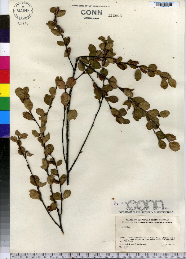
"dwc:locality": "Kinross: 2.4 miles northeast of Kinross Airport Road on highway U.S. 2, along little stream bordered bu shrub willow swamp (7.8 miles north-east of Rudyard).",
"dwc:institutionCode": "UConn",
"dwc:reproductiveCondition": "fruiting",
"dwc:higherClassification": "Plantae; Dicotyledonae; Fagales; Betulaceae",
"dwc:catalogNumber": "CONN00045910",
"dwc:higherGeography": "USA; Michigan; Chippewa County; Kinross",
"dwc:month": "9",
"dwc:decimalLongitude": "-84.51472",
"dwc:verbatimLongitude": "84°30' 53\" W",
"dwc:verbatimEventDate": "10-Sep-51",
"dwc:recordNumber": "336",
"dcterms:rights": "This work is licensed under a Creative Commons CCZero 1.0 License http://i.creativecommons.org/l/by-nc-sa/4.0/88x31.png",
"dcterms:modified": "2009-12-30T00:00-0500",
"dwc:scientificName": "Betula nana L.",
"dwc:day": "10",
"dwc:datasetID": "78382",
"dwc:year": "1951"
},
"indexTerms": {
"geopoint": {
"lat": 46.275,
"lon": -84.51472
},
"family": "betulaceae",
"recordset": "e70af26a-fb9e-43ab-96a0-d62a2df37e6d",
"dqs": 0.36231884057971014,
"stateprovince": "michigan",
"institutioncode": "uconn",
"municipality": "kinross",
"county": "chippewa county",
"catalognumber": "conn00045910",
"startdayofyear": 253,
"collector": "h.h. bartlett & c.d. richards",
"continent": "north america",
"uuid": "90d57b3b-cdf2-47ee-9708-3baef95ffc5e",
"countrycode": "usa",
"basisofrecord": "preservedspecimen",
"commonnames": [
"Birch"
],
"mediarecords": [
"31f753a7-10c9-418c-88b9-912b5e141b8a"
],
"datecollected": "1951-09-10T00:00:00+00:00",
"etag": "066773eaa4bf212b4cc48d6723f3e2e2d3826ba7",
"recordnumber": "336",
"hasImage": true,
"kingdom": "dicotyledonae",
"highertaxon": "plantae; dicotyledonae; fagales; betulaceae",
"commonname": "birch",
"scientificname": "betula nana l.",
"indexData": {
"dwc:countryCode": "US",
"dwc:county": "Chippewa County",
"dwc:recordedBy": "H.H. Bartlett & C.D. Richards",
"idigbio:uuid": "90d57b3b-cdf2-47ee-9708-3baef95ffc5e",
"dwc:georeferenceSources": "no date. USGS Geographic Names Information System (GNIS). U. S. Geological Survey.",
"dwc:order": "Fagales",
"idigbio:isocountrycode": "usa",
"dwc:locality": "Kinross: 2.4 miles northeast of Kinross Airport Road on highway U.S. 2, along little stream bordered bu shrub willow swamp (7.8 miles north-east of Rudyard).",
"idigbio:recordIds": [
"e70af26a-fb9e-43ab-96a0-d62a2df37e6d\\urn:catalog:uconn:conn:conn00045910"
],
"dwc:occurrenceID": "urn:catalog:UConn:CONN:CONN00045910",
"dwc:scientificName": "Betula nana L.",
"idigbio:parent": "e70af26a-fb9e-43ab-96a0-d62a2df37e6d",
"dwc:stateProvince": "Michigan",
"dwc:eventDate": "1951-09-10",
"dwc:country": "united states",
"idigbio:etag": "066773eaa4bf212b4cc48d6723f3e2e2d3826ba7",
"dwc:collectionCode": "CONN",
"dwc:verbatimLatitude": "46°16' 30\" N",
"dwc:kingdom": "Dicotyledonae",
"dwc:decimalLatitude": "46.275",
"dwc:basisOfRecord": "Preserved Specimen",
"dwc:genus": "Betula",
"dwc:continent": "north america",
"dwc:family": "Betulaceae",
"flag_dwc_continent_added": true,
"flag_dwc_country_replaced": true,
"dwc:municipality": "Kinross",
"dwc:previousIdentifications": "Betula L.",
"idigbio:siblings": {
"mediarecord": [
"31f753a7-10c9-418c-88b9-912b5e141b8a"
]
},
"flag_idigbio_isocountrycode_added": true,
"dwc:vernacularName": "Birch",
"idigbio:dateModified": "2014-09-12T19:13:08.646000",
"dwc:locationAccordingTo": "seconds added from gazetteer",
"dwc:institutionCode": "UConn",
"dwc:reproductiveCondition": "fruiting",
"dwc:higherClassification": "Plantae; Dicotyledonae; Fagales; Betulaceae",
"dwc:catalogNumber": "CONN00045910",
"dwc:higherGeography": "USA; Michigan; Chippewa County; Kinross",
"dwc:month": "9",
"dwc:decimalLongitude": "-84.51472",
"dwc:verbatimLongitude": "84°30' 53\" W",
"dwc:verbatimEventDate": "10-Sep-51",
"dwc:recordNumber": "336",
"dcterms:rights": "This work is licensed under a Creative Commons CCZero 1.0 License http://i.creativecommons.org/l/by-nc-sa/4.0/88x31.png",
"flag_taxon_match_failed": true,
"dcterms:modified": "2009-12-30T00:00-0500",
"dwc:coordinateUncertaintyInMeters": "5000",
"dwc:day": "10",
"dwc:datasetID": "78382",
"dwc:year": "1951"
},
"hasMedia": true,
"coordinateuncertainty": 5000,
"datemodified": "2014-09-12T19:13:08.646000+00:00",
"occurrenceid": "urn:catalog:uconn:conn:conn00045910",
"country": "united states",
"locality": "kinross: 2.4 miles northeast of kinross airport road on highway u.s. 2, along little stream bordered bu shrub willow swamp (7.8 miles north-east of rudyard).",
"collectioncode": "conn",
"eventdate": "1951-09-10",
"flags": [
"geopoint_datum_missing",
"dwc_continent_added",
"dwc_country_replaced",
"idigbio_isocountrycode_added",
"taxon_match_failed"
],
"verbatimeventdate": "10-sep-51",
"recordids": [
"e70af26a-fb9e-43ab-96a0-d62a2df37e6d\\urn:catalog:uconn:conn:conn00045910"
],
"genus": "betula",
"order": "fagales",
"datasetid": "78382"
},
"attribution": {
"totalCount": 172098
}
}