{
"uuid": "8002c179-fec4-4e51-a295-f2b7bc0a1915",
"type": "records",
"etag": "e218bbeb6e744daf752ee3ee4e6e63a816305fac",
"data": {
"dwc:startDayOfYear": "151",
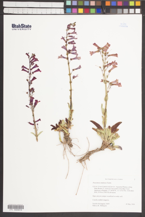
"dwc:specificEpithet": "utahensis",
"dwc:county": "Garfield",
"dwc:recordedBy": "Noel H. Holmgren; Patricia K. Holmgren",
"dwc:order": "Lamiales",
"dwc:habitat": "Open pinyon-juniper woodland.; Rocky soil.",
"dwc:scientificNameAuthorship": "Eastw.",
"dwc:occurrenceID": "78f42ee2-ea2b-42fe-9ef6-54662eeac8ba",
"dwc:dateIdentified": "Assumed to be year collected",
"dcterms:language": "English (USA)",
"dwc:verbatimCoordinates": "37° 56' 09'' N 111° 25' 52'' W; TRS: T33S R4E sec 14 SLUT",
"dwc:verbatimElevation": "7055ft",
"id": "3224757",
"dwc:taxonID": "3231",
"dwc:stateProvince": "Utah",
"dwc:eventDate": "2008-05-30",
"symbiota:recordEnteredBy": "thomasphelps",
"dwc:collectionID": "06bf658d-f555-4c9c-ab93-fc2d7db7086e",
"dwc:country": "United States",
"dwc:collectionCode": "UTC",
"dcterms:rightsHolder": "Utah State University",
"dwc:kingdom": "Plantae",
"dwc:decimalLatitude": "37.935833",
"dwc:occurrenceRemarks": "Corolla reddish magenta.",
"dwc:basisOfRecord": "PreservedSpecimen",
"dwc:genus": "Penstemon",
"dwc:family": "Scrophulariaceae",
"dc:rights": "http://creativecommons.org/publicdomain/zero/1.0/",
"dwc:identifiedBy": "Assumed to be collector",
"symbiota:recordID": "78f42ee2-ea2b-42fe-9ef6-54662eeac8ba",
"dwc:phylum": "Magnoliophyta",
"dcterms:references": "https://intermountainbiota.org/portal/collections/individual/index.php?occid=3224757",
"dwc:locality": "Aquarius Plateau, along State Route 12, 4 km (2.5 mi) north of the Burr Trail Junction in Boulder.",
"dwc:institutionCode": "Utah State University",
"dwc:taxonRank": "Species",
"dwc:reproductiveCondition": "Flowering",
"dwc:higherClassification": "Plantae|Magnoliophyta|Eudicots|Core Eudicots|Lamiids|Asterids|Lamiales|Plantaginaceae|Penstemon",
"dwc:catalogNumber": "UTC00258418",
"dwc:decimalLongitude": "-111.431111",
"dwc:recordNumber": "15695",
"dwc:minimumElevationInMeters": "2150",
"dcterms:modified": "2022-02-26 07:59:34",
"dwc:scientificName": "Penstemon utahensis"
},
"indexTerms": {
"geopoint": {
"lat": 37.935833,
"lon": -111.431111
},
"family": "plantaginaceae",
"recordset": "215eeaf0-0a88-409e-a75d-aec98b7c41eb",
"dqs": 0.2463768115942029,
"stateprovince": "utah",
"county": "garfield",
"phylum": "tracheophyta",
"catalognumber": "utc00258418",
"startdayofyear": 151,
"taxonrank": "genus",
"specificepithet": "utahensis",
"continent": "north america",
"uuid": "8002c179-fec4-4e51-a295-f2b7bc0a1915",
"countrycode": "usa",
"basisofrecord": "preservedspecimen",
"collector": "noel h. holmgren; patricia k. holmgren",
"institutioncode": "utah state university",
"mediarecords": [
"542e97bd-5cbd-4901-88cc-b630f55162b5"
],
"datemodified": "2022-12-06T21:46:54.888074+00:00",
"datecollected": "2008-05-30T00:00:00+00:00",
"etag": "e218bbeb6e744daf752ee3ee4e6e63a816305fac",
"recordnumber": "15695",
"minelevation": 2150,
"hasImage": true,
"kingdom": "plantae",
"highertaxon": "plantae|magnoliophyta|eudicots|core eudicots|lamiids|asterids|lamiales|plantaginaceae|penstemon",
"collectionid": "06bf658d-f555-4c9c-ab93-fc2d7db7086e",
"taxonid": "3171306",
"scientificname": "penstemon utahensis",
"indexData": {
"dwc:startDayOfYear": "151",
"flag_dwc_family_replaced": true,
"dwc:specificEpithet": "utahensis",
"idigbio:dateModified": "2022-12-06T21:46:54.888074",
"dwc:county": "Garfield",
"dwc:recordedBy": "Noel H. Holmgren; Patricia K. Holmgren",
"idigbio:uuid": "8002c179-fec4-4e51-a295-f2b7bc0a1915",
"flag_dwc_multimedia_added": true,
"dwc:order": "Lamiales",
"dwc:habitat": "Open pinyon-juniper woodland.; Rocky soil.",
"dwc:scientificNameAuthorship": "schmidel",
"flag_dwc_taxonid_replaced": true,
"dwc:occurrenceID": "78f42ee2-ea2b-42fe-9ef6-54662eeac8ba",
"dwc:dateIdentified": "Assumed to be year collected",
"flag_dwc_taxonrank_replaced": true,
"dcterms:language": "English (USA)",
"dwc:verbatimCoordinates": "37° 56' 09'' N 111° 25' 52'' W; TRS: T33S R4E sec 14 SLUT",
"dwc:verbatimElevation": "7055ft",
"flag_dwc_taxonomicstatus_added": true,
"flag_gbif_genericname_added": true,
"symbiota:recordEnteredBy": "thomasphelps",
"dwc:taxonID": "3171306",
"idigbio:parent": "215eeaf0-0a88-409e-a75d-aec98b7c41eb",
"dwc:stateProvince": "Utah",
"flag_gbif_taxon_corrected": true,
"dwc:parentnameusageid": "2420",
"dwc:eventDate": "2008-05-30",
"flag_dwc_scientificnameauthorship_replaced": true,
"dwc:collectionID": "06bf658d-f555-4c9c-ab93-fc2d7db7086e",
"dwc:country": "United States",
"id": "3224757",
"dwc:multimedia": [
{
"dcterms:license": "gnu free documentation license",
"dcterms:title": "balloon flower (penstemon palmeri)",
"dcterms:references": "http://commons.wikimedia.org/wiki/file:penstemon_palmeri_closeup-400px.jpg",
"coreid": "3171306",
"dcterms:identifier": "http://upload.wikimedia.org/wikipedia/commons/a/a8/penstemon_palmeri_closeup-400px.jpg",
"dcterms:source": "english wikipedia - species pages",
"dcterms:description": "english: photo of penstemon palmeri in red rock canyon, nevada",
"dcterms:creator": "stan shebs",
"dcterms:publisher": "wikimedia commons"
},
{
"dcterms:license": "gnu free documentation license",
"dcterms:title": "penstemon bridgesii",
"dcterms:references": "http://commons.wikimedia.org/wiki/file:penstemon_bridgesii3.jpg",
"coreid": "3171306",
"dcterms:identifier": "http://upload.wikimedia.org/wikipedia/commons/f/f6/penstemon_bridgesii3.jpg",
"dcterms:source": "german wikipedia - species pages",
"dcterms:created": "2004-01-01",
"dcterms:description": "species: penstemon bridgesii family: scrophulariaceae image no. 4",
"dcterms:creator": "kurt stüber [1]",
"dcterms:publisher": "wikimedia commons"
}
],
"idigbio:etag": "e218bbeb6e744daf752ee3ee4e6e63a816305fac",
"dwc:collectionCode": "UTC",
"dcterms:rightsHolder": "Utah State University",
"dwc:kingdom": "Plantae",
"dwc:decimalLatitude": "37.935833",
"dwc:occurrenceRemarks": "Corolla reddish magenta.",
"dwc:basisOfRecord": "PreservedSpecimen",
"dwc:taxonomicstatus": "accepted",
"dwc:genus": "Penstemon",
"dwc:continent": "north america",
"dwc:family": "plantaginaceae",
"dc:rights": "http://creativecommons.org/publicdomain/zero/1.0/",
"dwc:identifiedBy": "Assumed to be collector",
"flag_dwc_datasetid_added": true,
"dwc:class": "magnoliopsida",
"idigbio:isocountrycode": "usa",
"idigbio:siblings": {
"mediarecord": [
"542e97bd-5cbd-4901-88cc-b630f55162b5"
]
},
"symbiota:recordID": "78f42ee2-ea2b-42fe-9ef6-54662eeac8ba",
"flag_idigbio_isocountrycode_added": true,
"gbif:canonicalname": "penstemon",
"dwc:phylum": "tracheophyta",
"dcterms:references": "https://intermountainbiota.org/portal/collections/individual/index.php?occid=3224757",
"gbif:genericname": "penstemon",
"dwc:locality": "Aquarius Plateau, along State Route 12, 4 km (2.5 mi) north of the Burr Trail Junction in Boulder.",
"flag_gbif_vernacularname_added": true,
"dwc:institutionCode": "Utah State University",
"dwc:taxonRank": "genus",
"dwc:reproductiveCondition": "Flowering",
"dwc:higherClassification": "Plantae|Magnoliophyta|Eudicots|Core Eudicots|Lamiids|Asterids|Lamiales|Plantaginaceae|Penstemon",
"dwc:catalogNumber": "UTC00258418",
"flag_dwc_phylum_replaced": true,
"flag_gbif_canonicalname_added": true,
"dwc:decimalLongitude": "-111.431111",
"flag_dwc_continent_added": true,
"idigbio:recordIds": [
"urn:uuid:78f42ee2-ea2b-42fe-9ef6-54662eeac8ba",
"215eeaf0-0a88-409e-a75d-aec98b7c41eb\\3224757",
"215eeaf0-0a88-409e-a75d-aec98b7c41eb\\urn:uuid:78f42ee2-ea2b-42fe-9ef6-54662eeac8ba",
"215eeaf0-0a88-409e-a75d-aec98b7c41eb\\78f42ee2-ea2b-42fe-9ef6-54662eeac8ba"
],
"dwc:recordNumber": "15695",
"dwc:datasetid": "7ddf754f-d193-4cc9-b351-99906754a03b",
"flag_dwc_parentnameusageid_added": true,
"flag_dwc_class_added": true,
"flag_taxon_match_failed": true,
"dwc:minimumElevationInMeters": "2150",
"dcterms:modified": "2022-02-26 07:59:34",
"dwc:scientificName": "Penstemon utahensis",
"gbif:vernacularname": [
{
"coreid": "3171306",
"dcterms:language": "de",
"dcterms:source": "german wikipedia - species pages",
"dwc:vernacularname": "bartfaden"
},
{
"coreid": "3171306",
"dcterms:language": "en",
"dcterms:source": "database of vascular plants of canada (vascan)",
"dwc:vernacularname": "beardtongue"
},
{
"coreid": "3171306",
"dcterms:language": "en",
"dcterms:source": "grin taxonomy",
"dwc:vernacularname": "beardtongue"
},
{
"coreid": "3171306",
"dcterms:language": "en",
"dcterms:source": "integrated taxonomic information system (itis)",
"dwc:vernacularname": "beardtongue"
},
{
"coreid": "3171306",
"dcterms:language": "fr",
"dcterms:source": "integrated taxonomic information system (itis)",
"dwc:vernacularname": "penstémons"
}
]
},
"hasMedia": true,
"class": "magnoliopsida",
"occurrenceid": "78f42ee2-ea2b-42fe-9ef6-54662eeac8ba",
"country": "united states",
"locality": "aquarius plateau, along state route 12, 4 km (2.5 mi) north of the burr trail junction in boulder.",
"collectioncode": "utc",
"canonicalname": "penstemon",
"eventdate": "2008-05-30",
"flags": [
"geopoint_datum_missing",
"dwc_family_replaced",
"dwc_multimedia_added",
"dwc_taxonid_replaced",
"dwc_taxonrank_replaced",
"dwc_taxonomicstatus_added",
"gbif_genericname_added",
"gbif_taxon_corrected",
"dwc_scientificnameauthorship_replaced",
"dwc_datasetid_added",
"idigbio_isocountrycode_added",
"gbif_vernacularname_added",
"dwc_phylum_replaced",
"gbif_canonicalname_added",
"dwc_continent_added",
"dwc_parentnameusageid_added",
"dwc_class_added",
"taxon_match_failed"
],
"taxonomicstatus": "accepted",
"recordids": [
"urn:uuid:78f42ee2-ea2b-42fe-9ef6-54662eeac8ba",
"215eeaf0-0a88-409e-a75d-aec98b7c41eb\\3224757",
"215eeaf0-0a88-409e-a75d-aec98b7c41eb\\urn:uuid:78f42ee2-ea2b-42fe-9ef6-54662eeac8ba",
"215eeaf0-0a88-409e-a75d-aec98b7c41eb\\78f42ee2-ea2b-42fe-9ef6-54662eeac8ba"
],
"genus": "penstemon",
"order": "lamiales",
"datasetid": "7ddf754f-d193-4cc9-b351-99906754a03b"
},
"attribution": {
"totalCount": 186686
}
}