{
"uuid": "7953ef44-3719-4eca-b292-5453178c0a45",
"type": "records",
"etag": "5d7a3a50467bff794f0b4e8b16dfe8be2a64cbad",
"data": {
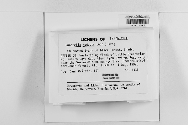
"dwc:startDayOfYear": "213",
"dwc:specificEpithet": "rudecta",
"dwc:county": "Sevier",
"dwc:recordedBy": "Dana Griffin, III",
"dwc:georeferenceSources": "georef batch tool 2015-09-02; GeoLocate",
"dwc:order": "Lecanorales",
"dwc:habitat": "hemlock-mixed hardwoods forest; on downed trunk of black locust. Shady",
"dwc:scientificNameAuthorship": "(Ach.) Krog",
"dwc:occurrenceID": "1381885",
"dwc:verbatimElevation": "1800 ft",
"symbiota:recordEnteredBy": "maysk12",
"dwc:stateProvince": "Tennessee",
"dwc:eventDate": "1999-08-01",
"dwc:collectionID": "2a40ef36-3117-4295-8c11-a672db19b4a0",
"dwc:country": "United States",
"idigbio:recordId": "urn:uuid:63341965-61d2-4467-b27f-e12142c36b78",
"dwc:georeferenceRemarks": "marker place at Lyon Springs Road",
"dwc:kingdom": "Fungi",
"dwc:decimalLatitude": "35.713376",
"dwc:georeferenceVerificationStatus": "reviewed - medium confidence",
"dwc:basisOfRecord": "PreservedSpecimen",
"dwc:genus": "Punctelia",
"dwc:family": "Parmeliaceae",
"dc:rights": "http://creativecommons.org/licenses/by-nc/3.0/",
"dwc:identifiedBy": "Dana Griffin III",
"dwc:phylum": "Ascomycota",
"dcterms:references": "http://lichenportal.org/portal/collections/individual/index.php?occid=1381885",
"dwc:locality": "West-facing flank of Little Greenbriar Mt. Wear's Cove Gap. Along Lyon Springs Road very near the Sevier-Blount county line",
"dwc:institutionCode": "FLAS",
"dwc:class": "Lecanoromycetes",
"dwc:catalogNumber": "FLAS L5965",
"dwc:month": "8",
"dwc:decimalLongitude": "-83.652589",
"dwc:coordinateUncertaintyInMeters": "500",
"dwc:georeferencedBy": "qianwang (2015-09-02 12:57:38)",
"dwc:verbatimEventDate": "1 Aug. 1999",
"dwc:recordNumber": "4415",
"dwc:minimumElevationInMeters": "549",
"dcterms:modified": "2015-09-02 15:57:38",
"dwc:scientificName": "Punctelia rudecta",
"dwc:day": "1",
"dwc:year": "1999"
},
"indexTerms": {
"geopoint": {
"lat": 35.713376,
"lon": -83.652589
},
"family": "parmeliaceae",
"recordset": "b5e5c781-765f-4981-af2a-c19c250e2cf0",
"dqs": 0.3188405797101449,
"stateprovince": "tennessee",
"county": "sevier",
"phylum": "ascomycota",
"catalognumber": "flas l5965",
"startdayofyear": 213,
"taxonrank": "species",
"specificepithet": "rudecta",
"continent": "north america",
"uuid": "7953ef44-3719-4eca-b292-5453178c0a45",
"countrycode": "usa",
"basisofrecord": "preservedspecimen",
"collector": "dana griffin, iii",
"institutioncode": "flas",
"mediarecords": [
"cc75bf71-1e65-4c55-9662-1ac7bc47641a"
],
"datemodified": "2016-04-07T16:58:19.070485+00:00",
"datecollected": "1999-08-01T00:00:00+00:00",
"etag": "5d7a3a50467bff794f0b4e8b16dfe8be2a64cbad",
"recordnumber": "4415",
"minelevation": 549,
"hasImage": true,
"kingdom": "fungi",
"collectionid": "2a40ef36-3117-4295-8c11-a672db19b4a0",
"taxonid": "2605231",
"scientificname": "punctelia rudecta",
"indexData": {
"dwc:startDayOfYear": "213",
"flag_dwc_taxonrank_added": true,
"dwc:specificEpithet": "rudecta",
"idigbio:dateModified": "2016-04-07T16:58:19.070485",
"dwc:county": "Sevier",
"dwc:recordedBy": "Dana Griffin, III",
"idigbio:uuid": "7953ef44-3719-4eca-b292-5453178c0a45",
"dwc:locality": "West-facing flank of Little Greenbriar Mt. Wear's Cove Gap. Along Lyon Springs Road very near the Sevier-Blount county line",
"dwc:order": "Lecanorales",
"dwc:habitat": "hemlock-mixed hardwoods forest; on downed trunk of black locust. Shady",
"dwc:scientificNameAuthorship": "krog (ach.)",
"idigbio:recordIds": [
"urn:uuid:63341965-61d2-4467-b27f-e12142c36b78",
"b5e5c781-765f-4981-af2a-c19c250e2cf0\\1381885"
],
"dwc:occurrenceID": "1381885",
"flag_gbif_canonicalname_added": true,
"flag_dwc_continent_added": true,
"dwc:verbatimElevation": "1800 ft",
"flag_dwc_taxonomicstatus_added": true,
"flag_gbif_genericname_added": true,
"symbiota:recordEnteredBy": "maysk12",
"flag_dwc_datasetid_added": true,
"idigbio:parent": "b5e5c781-765f-4981-af2a-c19c250e2cf0",
"dwc:stateProvince": "Tennessee",
"flag_dwc_originalnameusageid_added": true,
"dwc:eventDate": "1999-08-01",
"flag_dwc_scientificnameauthorship_replaced": true,
"dwc:collectionID": "2a40ef36-3117-4295-8c11-a672db19b4a0",
"dwc:country": "United States",
"idigbio:recordId": "urn:uuid:63341965-61d2-4467-b27f-e12142c36b78",
"idigbio:etag": "5d7a3a50467bff794f0b4e8b16dfe8be2a64cbad",
"dwc:decimalLatitude": "35.713376",
"dwc:kingdom": "Fungi",
"dwc:georeferenceRemarks": "marker place at Lyon Springs Road",
"dwc:georeferenceVerificationStatus": "reviewed - medium confidence",
"dwc:basisOfRecord": "PreservedSpecimen",
"dwc:taxonomicstatus": "accepted",
"dwc:genus": "Punctelia",
"dwc:continent": "north america",
"dwc:family": "Parmeliaceae",
"dc:rights": "http://creativecommons.org/licenses/by-nc/3.0/",
"dwc:identifiedBy": "Dana Griffin III",
"flag_dwc_taxonid_added": true,
"idigbio:isocountrycode": "usa",
"idigbio:siblings": {
"mediarecord": [
"cc75bf71-1e65-4c55-9662-1ac7bc47641a"
]
},
"flag_idigbio_isocountrycode_added": true,
"gbif:canonicalname": "punctelia rudecta",
"dwc:phylum": "Ascomycota",
"dcterms:references": "http://lichenportal.org/portal/collections/individual/index.php?occid=1381885",
"gbif:genericname": "punctelia",
"dwc:georeferenceSources": "georef batch tool 2015-09-02; GeoLocate",
"dwc:institutionCode": "FLAS",
"flag_gbif_taxon_corrected": true,
"dwc:parentnameusageid": "2605197",
"dwc:class": "Lecanoromycetes",
"dwc:catalogNumber": "FLAS L5965",
"dwc:taxonid": "2605231",
"dwc:taxonrank": "species",
"dwc:month": "8",
"dwc:decimalLongitude": "-83.652589",
"dwc:scientificName": "Punctelia rudecta",
"dwc:georeferencedBy": "qianwang (2015-09-02 12:57:38)",
"dwc:verbatimEventDate": "1 Aug. 1999",
"dwc:originalnameusageid": "8397629",
"dwc:recordNumber": "4415",
"dwc:datasetid": "a6c6cead-b5ce-4a4e-8cf5-1542ba708dec",
"flag_dwc_parentnameusageid_added": true,
"dwc:minimumElevationInMeters": "549",
"dcterms:modified": "2015-09-02 15:57:38",
"dwc:coordinateUncertaintyInMeters": "500",
"dwc:day": "1",
"dwc:year": "1999"
},
"hasMedia": true,
"coordinateuncertainty": 500,
"class": "lecanoromycetes",
"occurrenceid": "1381885",
"country": "united states",
"locality": "west-facing flank of little greenbriar mt. wear's cove gap. along lyon springs road very near the sevier-blount county line",
"canonicalname": "punctelia rudecta",
"eventdate": "1999-08-01",
"flags": [
"geopoint_datum_missing",
"dwc_taxonrank_added",
"gbif_canonicalname_added",
"dwc_continent_added",
"dwc_taxonomicstatus_added",
"gbif_genericname_added",
"dwc_datasetid_added",
"dwc_originalnameusageid_added",
"dwc_scientificnameauthorship_replaced",
"dwc_taxonid_added",
"idigbio_isocountrycode_added",
"gbif_taxon_corrected",
"dwc_parentnameusageid_added"
],
"verbatimeventdate": "1 aug. 1999",
"taxonomicstatus": "accepted",
"recordids": [
"urn:uuid:63341965-61d2-4467-b27f-e12142c36b78",
"b5e5c781-765f-4981-af2a-c19c250e2cf0\\1381885"
],
"genus": "punctelia",
"order": "lecanorales",
"datasetid": "a6c6cead-b5ce-4a4e-8cf5-1542ba708dec"
},
"attribution": {
"totalCount": 10820
}
}