{
"uuid": "6e2299de-3e26-4ac0-9732-e120548bbf57",
"type": "records",
"etag": "7b4007d15c796739ea8cb4124fe483682eea5514",
"data": {
"dwc:startDayOfYear": "242",
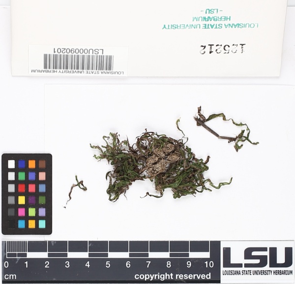
"dwc:specificEpithet": "lyellii",
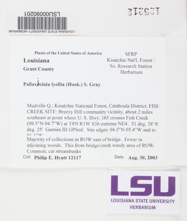
"dwc:county": "Grant",
"dwc:recordedBy": "Philip E. Hyatt",
"dwc:order": "Pallaviciniales",
"dwc:habitat": "Majority of collections in ROW east of bridge. Fewer in adjoining woods. This from bridge/creek weedy area of ROW. cut streambanks.",
"dwc:scientificNameAuthorship": "(Hook.) Gray",
"dwc:georeferenceRemarks": "lat/long = on label",
"dwc:occurrenceID": "a39fdedf-923c-4f7d-b012-74b33c71a993",
"dcterms:language": "en",
"dwc:verbatimCoordinates": "31° 38' N, 92° 25' W",
"id": "2186194",
"dwc:taxonID": "160146",
"dwc:stateProvince": "Louisiana",
"dwc:locationRemarks": "Kisatchie National Forest",
"dwc:eventDate": "2003-08-30",
"dwc:collectionID": "fce06a6b-7beb-4cd4-a8fa-f1a0f271ad1f",
"dwc:country": "United States",
"dwc:collectionCode": "Bryophytes",
"dwc:higherClassification": "Plantae|Bryobiotina|Marchantiophyta|Jungermanniopsida|Pelliidae|Pallaviciniales|Pallaviciniaceae|Pallavicinia",
"dwc:kingdom": "Plantae",
"dwc:decimalLatitude": "31.633333",
"dwc:occurrenceRemarks": "Common",
"dwc:basisOfRecord": "PreservedSpecimen",
"dwc:genus": "Pallavicinia",
"dwc:family": "Pallaviciniaceae",
"dc:rights": "http://creativecommons.org/licenses/by-nc/3.0/",
"symbiota:recordID": "a39fdedf-923c-4f7d-b012-74b33c71a993",
"dwc:phylum": "Marchantiophyta",
"dcterms:references": "https://bryophyteportal.org/portal/collections/individual/index.php?occid=2186194",
"dwc:locality": "Mudville Q.; Kisatchie Ntional Forest, Catahoula District; Fish Creek Site: Breezy Hill community vicinity, about 2 miles southeast at point where US highway 165 crosses Fish Creek (09.5\"N 04.7\"W) at T8N R1W Sec 36 extreme NE4. 31 38' 92 25' Garmin III GPSed. Site edges 04.5\"N 05.4\"W and to 01.1W.",
"dwc:institutionCode": "LSU",
"dwc:taxonRank": "Species",
"dwc:class": "Jungermanniopsida",
"dwc:catalogNumber": "LSU00090201",
"dwc:taxonRemarks": "hepatic",
"dwc:month": "8",
"dwc:decimalLongitude": "-92.416667",
"dwc:coordinateUncertaintyInMeters": "1000",
"dwc:otherCatalogNumbers": "125212",
"dwc:georeferencedBy": "adurha5",
"dwc:verbatimEventDate": "Aug. 30, 2003",
"dwc:recordNumber": "12117",
"dwc:preparations": "1",
"dcterms:modified": "2022-11-02 09:20:24",
"dwc:scientificName": "Pallavicinia lyellii",
"dwc:day": "30",
"dwc:year": "2003"
},
"indexTerms": {
"geopoint": {
"lat": 31.633333,
"lon": -92.416667
},
"family": "pallaviciniaceae",
"recordset": "8e5fffb5-0b22-472d-8386-de291d17d513",
"dqs": 0.3188405797101449,
"stateprovince": "louisiana",
"county": "grant",
"phylum": "marchantiophyta",
"catalognumber": "lsu00090201",
"startdayofyear": 242,
"taxonrank": "species",
"specificepithet": "lyellii",
"continent": "north america",
"uuid": "6e2299de-3e26-4ac0-9732-e120548bbf57",
"countrycode": "usa",
"basisofrecord": "preservedspecimen",
"collector": "philip e. hyatt",
"institutioncode": "lsu",
"mediarecords": [
"cfa92eea-32de-4d92-a1cb-1cc1877e2c8d",
"d99c910c-f5fc-453b-8188-fb950cb270fa"
],
"datemodified": "2023-01-11T03:53:53.499737+00:00",
"datecollected": "2003-08-30T00:00:00+00:00",
"etag": "7b4007d15c796739ea8cb4124fe483682eea5514",
"recordnumber": "12117",
"hasImage": true,
"kingdom": "plantae",
"highertaxon": "plantae|bryobiotina|marchantiophyta|jungermanniopsida|pelliidae|pallaviciniales|pallaviciniaceae|pallavicinia",
"collectionid": "fce06a6b-7beb-4cd4-a8fa-f1a0f271ad1f",
"taxonid": "5286309",
"scientificname": "pallavicinia lyellii",
"indexData": {
"dwc:startDayOfYear": "242",
"dwc:specificEpithet": "lyellii",
"idigbio:dateModified": "2023-01-11T03:53:53.499737",
"dwc:county": "Grant",
"dwc:recordedBy": "Philip E. Hyatt",
"idigbio:uuid": "6e2299de-3e26-4ac0-9732-e120548bbf57",
"dwc:order": "Pallaviciniales",
"dwc:habitat": "Majority of collections in ROW east of bridge. Fewer in adjoining woods. This from bridge/creek weedy area of ROW. cut streambanks.",
"flag_gbif_reference_added": true,
"dwc:scientificNameAuthorship": "carruth. (hook.)",
"flag_dwc_taxonid_replaced": true,
"dwc:occurrenceID": "a39fdedf-923c-4f7d-b012-74b33c71a993",
"flag_gbif_canonicalname_added": true,
"dcterms:language": "en",
"dwc:verbatimCoordinates": "31° 38' N, 92° 25' W",
"dwc:decimalLatitude": "31.633333",
"flag_gbif_genericname_added": true,
"id": "2186194",
"dwc:taxonID": "5286309",
"idigbio:parent": "8e5fffb5-0b22-472d-8386-de291d17d513",
"dwc:stateProvince": "Louisiana",
"dwc:taxonRank": "Species",
"dwc:datasetid": "7ddf754f-d193-4cc9-b351-99906754a03b",
"dwc:eventDate": "2003-08-30",
"flag_gbif_taxon_corrected": true,
"dwc:collectionID": "fce06a6b-7beb-4cd4-a8fa-f1a0f271ad1f",
"dwc:country": "United States",
"idigbio:etag": "7b4007d15c796739ea8cb4124fe483682eea5514",
"dwc:collectionCode": "Bryophytes",
"dwc:class": "Jungermanniopsida",
"dwc:kingdom": "Plantae",
"dwc:georeferenceRemarks": "lat/long = on label",
"dwc:occurrenceRemarks": "Common",
"dwc:basisOfRecord": "PreservedSpecimen",
"dwc:taxonomicstatus": "accepted",
"dwc:genus": "Pallavicinia",
"dwc:continent": "north america",
"dwc:family": "Pallaviciniaceae",
"dc:rights": "http://creativecommons.org/licenses/by-nc/3.0/",
"flag_dwc_parentnameusageid_added": true,
"flag_dwc_datasetid_added": true,
"gbif:vernacularname": [
{
"dwc:countrycode": "be",
"dwc:country": "belgium",
"dwc:vernacularname": "elzenmos",
"coreid": "5286309",
"dcterms:source": "belgian species list",
"dcterms:language": "nl"
},
{
"coreid": "5286309",
"dcterms:language": "nl",
"dcterms:source": "checklist dutch species catalog - nederlands soortenregister",
"dwc:vernacularname": "elzenmos"
},
{
"dwc:countrycode": "de",
"dwc:country": "germany",
"dwc:vernacularname": "lyells palavicinimoos",
"coreid": "5286309",
"dcterms:source": "taxon list of liverworts from germany compiled in the context of the gbol project",
"dcterms:language": "de"
}
],
"idigbio:isocountrycode": "usa",
"flag_dwc_continent_added": true,
"idigbio:siblings": {
"mediarecord": [
"cfa92eea-32de-4d92-a1cb-1cc1877e2c8d",
"d99c910c-f5fc-453b-8188-fb950cb270fa"
]
},
"symbiota:recordID": "a39fdedf-923c-4f7d-b012-74b33c71a993",
"flag_idigbio_isocountrycode_added": true,
"gbif:canonicalname": "pallavicinia lyellii",
"dwc:phylum": "Marchantiophyta",
"dcterms:references": "https://bryophyteportal.org/portal/collections/individual/index.php?occid=2186194",
"gbif:genericname": "pallavicinia",
"dwc:locality": "Mudville Q.; Kisatchie Ntional Forest, Catahoula District; Fish Creek Site: Breezy Hill community vicinity, about 2 miles southeast at point where US highway 165 crosses Fish Creek (09.5\"N 04.7\"W) at T8N R1W Sec 36 extreme NE4. 31 38' 92 25' Garmin III GPSed. Site edges 04.5\"N 05.4\"W and to 01.1W.",
"flag_gbif_vernacularname_added": true,
"dwc:institutionCode": "LSU",
"dwc:locationRemarks": "Kisatchie National Forest",
"dwc:parentnameusageid": "2932907",
"dwc:higherClassification": "Plantae|Bryobiotina|Marchantiophyta|Jungermanniopsida|Pelliidae|Pallaviciniales|Pallaviciniaceae|Pallavicinia",
"dwc:catalogNumber": "LSU00090201",
"gbif:reference": [
{
"coreid": "5286309",
"dcterms:source": "catalogue of life",
"dcterms:bibliographiccitation": "(1821) a natural arrangement of british plants 1: 685, 775. 1821"
}
],
"dwc:taxonRemarks": "hepatic",
"flag_dwc_scientificnameauthorship_replaced": true,
"dwc:month": "8",
"dwc:decimalLongitude": "-92.416667",
"dwc:scientificName": "Pallavicinia lyellii",
"flag_dwc_taxonomicstatus_added": true,
"dwc:otherCatalogNumbers": "125212",
"dwc:georeferencedBy": "adurha5",
"dwc:verbatimEventDate": "Aug. 30, 2003",
"dwc:originalnameusageid": "4277696",
"idigbio:recordIds": [
"urn:uuid:a39fdedf-923c-4f7d-b012-74b33c71a993",
"8e5fffb5-0b22-472d-8386-de291d17d513\\2186194",
"8e5fffb5-0b22-472d-8386-de291d17d513\\urn:uuid:a39fdedf-923c-4f7d-b012-74b33c71a993",
"8e5fffb5-0b22-472d-8386-de291d17d513\\a39fdedf-923c-4f7d-b012-74b33c71a993"
],
"dwc:recordNumber": "12117",
"dwc:preparations": "1",
"flag_dwc_originalnameusageid_added": true,
"dcterms:modified": "2022-11-02 09:20:24",
"dwc:coordinateUncertaintyInMeters": "1000",
"dwc:day": "30",
"dwc:year": "2003"
},
"hasMedia": true,
"coordinateuncertainty": 1000,
"class": "jungermanniopsida",
"occurrenceid": "a39fdedf-923c-4f7d-b012-74b33c71a993",
"country": "united states",
"locality": "mudville q.; kisatchie ntional forest, catahoula district; fish creek site: breezy hill community vicinity, about 2 miles southeast at point where us highway 165 crosses fish creek (09.5\"n 04.7\"w) at t8n r1w sec 36 extreme ne4. 31 38' 92 25' garmin iii gpsed. site edges 04.5\"n 05.4\"w and to 01.1w.",
"collectioncode": "bryophytes",
"canonicalname": "pallavicinia lyellii",
"eventdate": "2003-08-30",
"flags": [
"geopoint_datum_missing",
"gbif_reference_added",
"dwc_taxonid_replaced",
"gbif_canonicalname_added",
"gbif_genericname_added",
"gbif_taxon_corrected",
"dwc_parentnameusageid_added",
"dwc_datasetid_added",
"dwc_continent_added",
"idigbio_isocountrycode_added",
"gbif_vernacularname_added",
"dwc_scientificnameauthorship_replaced",
"dwc_taxonomicstatus_added",
"dwc_originalnameusageid_added"
],
"verbatimeventdate": "aug. 30, 2003",
"taxonomicstatus": "accepted",
"recordids": [
"urn:uuid:a39fdedf-923c-4f7d-b012-74b33c71a993",
"8e5fffb5-0b22-472d-8386-de291d17d513\\2186194",
"8e5fffb5-0b22-472d-8386-de291d17d513\\urn:uuid:a39fdedf-923c-4f7d-b012-74b33c71a993",
"8e5fffb5-0b22-472d-8386-de291d17d513\\a39fdedf-923c-4f7d-b012-74b33c71a993"
],
"genus": "pallavicinia",
"order": "pallaviciniales",
"datasetid": "7ddf754f-d193-4cc9-b351-99906754a03b"
},
"attribution": {
"totalCount": 9574
}
}