{
"uuid": "6ae81a0a-2529-415b-8e83-f25ff91ca8e2",
"type": "records",
"etag": "6eac34510394e007fa78b5a4e797079a40074bf5",
"data": {
"dwc:identificationRemarks": "Former nature_of_id: field.",
"dwc:verbatimCoordinates": "64.0666666667/-146.5166666667",
"dwc:kingdom": "Animalia",
"dwc:recordedBy": "Collector(s): Art Greenwalt",
"dwc:georeferencedDate": "2012-06-03 00:00:00",
"dcterms:references": "http://arctos.database.museum/guid/UAM:ES:26533",
"dcterms:accessRights": "http://vertnet.org/resources/norms.html",
"dwc:occurrenceID": "http://arctos.database.museum/guid/UAM:ES:26533?seid=95461",
"id": "http://arctos.database.museum/guid/UAM:ES:26533?seid=95461",
"dwc:establishmentMeans": "wild",
"dwc:stateProvince": "Alaska",
"dwc:eventDate": "1969-01-01/1983-12-31",
"dwc:collectionID": "21",
"dwc:institutionCode": "UAM",
"dwc:country": "United States",
"dwc:earliestPeriodOrLowestSystem": "Quaternary",
"dwc:collectionCode": "ES",
"dwc:higherClassification": "Animalia, Chordata,",
"dwc:decimalLatitude": "64.8993810000",
"dwc:georeferenceVerificationStatus": "unverified",
"dwc:basisOfRecord": "PreservedSpecimen",
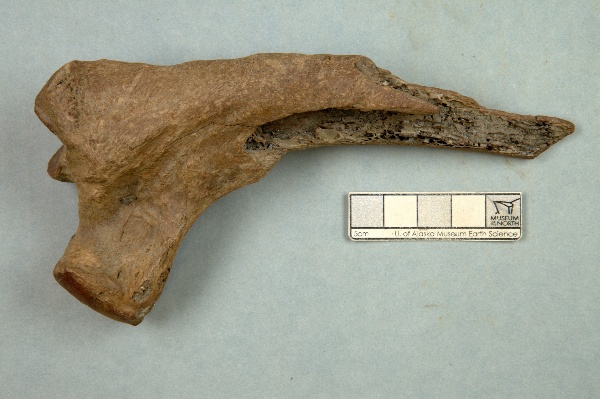
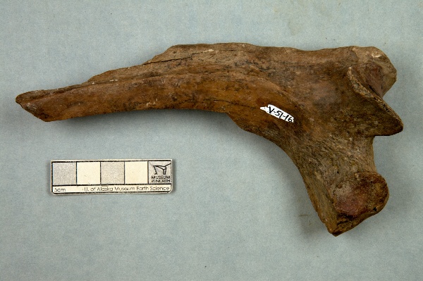
"dwc:preparations": "rib",
"dwc:identifiedBy": "unknown",
"dwc:identificationVerificationStatus": "features",
"dwc:georeferenceSources": "GeoLocate",
"dwc:previousIdentifications": "[{\"scientific_name\":\"Mammalia\",\"nature_of_id\":\"features\",\"accepted_id_fg\":1,\"made_date\":null,\"short_citation\":null,\"publication_id\":null,\"identification_remarks\":\"Former nature_of_id: field.\",\"idby\":\"unknown\",\"concept_label\":null}]",
"dwc:organismID": "http://arctos.database.museum/guid/UAM:ES:26533",
"dwc:phylum": "Chordata",
"dwc:locationAccordingTo": "unknown",
"dwc:locality": "Chena River bluff, mile 34.8 Chena Hot Springs Highway, Big Delta Quad",
"dwc:institutionID": "UAM",
"dwc:associatedMedia": "http://arctos.database.museum/MediaSearch.cfm?collection_object_id=22461185",
"dwc:geodeticDatum": "unknown",
"dwc:taxonRank": "class",
"dwc:class": "Mammalia",
"dwc:catalogNumber": "UAM:ES:26533",
"dwc:nomenclaturalCode": "ICZN",
"dwc:higherGeography": "United States, Alaska",
"dwc:decimalLongitude": "-146.5106990000",
"dwc:coordinateUncertaintyInMeters": "150",
"dwc:otherCatalogNumbers": "Locality ID=AK-51-V-, other identifier=AK-51-V-016",
"dwc:verbatimLocality": "Chena River off the highway (Chena Hot Springs Road) at mile 34, large muck bank on south side of the river",
"dwc:georeferencedBy": "unknown",
"dwc:verbatimEventDate": "1969-1983",
"dwc:eventTime": "1969-01-01/1983-12-31",
"dwc:identificationQualifier": "A",
"dwc:verbatimCoordinateSystem": "decimal degrees",
"dwc:georeferenceProtocol": "GeoLocate",
"dcterms:modified": "2022-10-26 08:47:44.692574",
"dwc:scientificName": "Mammalia",
"dwc:footprintWKT": "POLYGON((-146.507530145302 64.8993705576976,-146.507595845274 64.8991081893283,-146.507780794143 64.8988563060216,-146.50807788153 64.8986245870857,-146.508475688628 64.8984219367217,-146.508958927305 64.8982561419354,-146.509509027716 64.8981335733991,-146.51010485182 64.8980589407409,-146.510723505392 64.8980351116497,-146.511341217392 64.8980630017323,-146.511934252936 64.8981415393477,-146.512479824896 64.8982677067654,-146.512956969157 64.8984366560698,-146.513347349959 64.8986418953678,-146.513635964442 64.8988755381567,-146.513811719304 64.8991286062873,-146.513867857423 64.8993913748958,-146.513802217974 64.8996537460636,-146.51361732 64.8999056368549,-146.51332026613 64.9001373668218,-146.51292247007 64.9003400300839,-146.51243921827 64.9005058376717,-146.511889082574 64.9006284169642,-146.511293206394 64.9007030566955,-146.510674491883 64.9007268881002,-146.51005671936 64.900698995219,-146.509463632922 64.900620450119,-146.508918027444 64.9004942716704,-146.508440872146 64.9003253094679,-146.508050504466 64.9001200573683,-146.507761925269 64.8998864038232,-146.507586222482 64.8996333286195,-146.507530145302 64.8993705576976))"
},
"indexTerms": {
"datemodified": "2022-12-07T00:43:16.130603+00:00",
"recordset": "2ec3b31e-c86b-4ce9-b265-77c8c3f9643c",
"dqs": 0.3333333333333333,
"stateprovince": "alaska",
"earliestperiodorlowestsystem": "quaternary",
"phylum": "chordata",
"catalognumber": "uam:es:26533",
"taxonrank": "class",
"collector": "collector(s): art greenwalt",
"verbatimlocality": "chena river off the highway (chena hot springs road) at mile 34, large muck bank on south side of the river",
"uuid": "6ae81a0a-2529-415b-8e83-f25ff91ca8e2",
"countrycode": "usa",
"basisofrecord": "preservedspecimen",
"institutioncode": "uam",
"mediarecords": [
"0d33a4b6-c454-43ac-bd2e-d5c482b0be84",
"b35bff7b-3ae6-491e-8dc7-5d9e41f02234"
],
"continent": "north america",
"etag": "6eac34510394e007fa78b5a4e797079a40074bf5",
"hasMedia": true,
"hasImage": true,
"kingdom": "animalia",
"highertaxon": "animalia, chordata,",
"collectionid": "21",
"scientificname": "mammalia",
"locality": "chena river bluff, mile 34.8 chena hot springs highway, big delta quad",
"coordinateuncertainty": 150,
"class": "mammalia",
"occurrenceid": "http://arctos.database.museum/guid/uam:es:26533?seid=95461",
"institutionid": "uam",
"country": "united states",
"geopoint": {
"lat": 64.899381,
"lon": -146.510699
},
"collectioncode": "es",
"flags": [
"geopoint_datum_error",
"dwc_continent_added",
"idigbio_isocountrycode_added",
"taxon_match_failed"
],
"verbatimeventdate": "1969-1983",
"recordids": [
"2ec3b31e-c86b-4ce9-b265-77c8c3f9643c\\urn:occurrence:arctos:uam:es:26533:95461",
"2ec3b31e-c86b-4ce9-b265-77c8c3f9643c\\http://arctos.database.museum/guid/uam:es:26533?seid=95461"
],
"eventdate": "1969-01-01/1983-12-31",
"indexData": {
"dwc:identificationRemarks": "Former nature_of_id: field.",
"dwc:verbatimCoordinates": "64.0666666667/-146.5166666667",
"idigbio:dateModified": "2022-12-07T00:43:16.130603",
"dwc:kingdom": "Animalia",
"dwc:recordedBy": "Collector(s): Art Greenwalt",
"idigbio:uuid": "6ae81a0a-2529-415b-8e83-f25ff91ca8e2",
"dwc:georeferencedDate": "2012-06-03 00:00:00",
"dcterms:references": "http://arctos.database.museum/guid/UAM:ES:26533",
"idigbio:isocountrycode": "usa",
"dcterms:accessRights": "http://vertnet.org/resources/norms.html",
"dwc:locality": "Chena River bluff, mile 34.8 Chena Hot Springs Highway, Big Delta Quad",
"idigbio:recordIds": [
"2ec3b31e-c86b-4ce9-b265-77c8c3f9643c\\urn:occurrence:arctos:uam:es:26533:95461",
"2ec3b31e-c86b-4ce9-b265-77c8c3f9643c\\http://arctos.database.museum/guid/uam:es:26533?seid=95461"
],
"dwc:occurrenceID": "http://arctos.database.museum/guid/UAM:ES:26533?seid=95461",
"id": "http://arctos.database.museum/guid/UAM:ES:26533?seid=95461",
"dwc:establishmentMeans": "wild",
"idigbio:parent": "2ec3b31e-c86b-4ce9-b265-77c8c3f9643c",
"dwc:stateProvince": "Alaska",
"dwc:eventDate": "1969-01-01/1983-12-31",
"dwc:collectionID": "21",
"dwc:country": "United States",
"dwc:earliestPeriodOrLowestSystem": "Quaternary",
"idigbio:etag": "6eac34510394e007fa78b5a4e797079a40074bf5",
"dwc:collectionCode": "ES",
"dwc:class": "Mammalia",
"dwc:decimalLatitude": "64.8993810000",
"dwc:georeferenceVerificationStatus": "unverified",
"dwc:basisOfRecord": "PreservedSpecimen",
"dwc:continent": "north america",
"dwc:preparations": "rib",
"flag_dwc_continent_added": true,
"dwc:identifiedBy": "unknown",
"dwc:identificationVerificationStatus": "features",
"dwc:previousIdentifications": "[{\"scientific_name\":\"Mammalia\",\"nature_of_id\":\"features\",\"accepted_id_fg\":1,\"made_date\":null,\"short_citation\":null,\"publication_id\":null,\"identification_remarks\":\"Former nature_of_id: field.\",\"idby\":\"unknown\",\"concept_label\":null}]",
"dwc:geodeticDatum": "unknown",
"idigbio:siblings": {
"mediarecord": [
"0d33a4b6-c454-43ac-bd2e-d5c482b0be84",
"b35bff7b-3ae6-491e-8dc7-5d9e41f02234"
]
},
"flag_idigbio_isocountrycode_added": true,
"dwc:organismID": "http://arctos.database.museum/guid/UAM:ES:26533",
"dwc:phylum": "Chordata",
"dwc:locationAccordingTo": "unknown",
"dwc:georeferenceSources": "GeoLocate",
"dwc:institutionID": "UAM",
"dwc:associatedMedia": "http://arctos.database.museum/MediaSearch.cfm?collection_object_id=22461185",
"dwc:institutionCode": "UAM",
"dwc:taxonRank": "class",
"dwc:higherClassification": "Animalia, Chordata,",
"dwc:catalogNumber": "UAM:ES:26533",
"dwc:nomenclaturalCode": "ICZN",
"dwc:higherGeography": "United States, Alaska",
"dwc:decimalLongitude": "-146.5106990000",
"dwc:scientificName": "Mammalia",
"dwc:otherCatalogNumbers": "Locality ID=AK-51-V-, other identifier=AK-51-V-016",
"dwc:verbatimLocality": "Chena River off the highway (Chena Hot Springs Road) at mile 34, large muck bank on south side of the river",
"dwc:georeferencedBy": "unknown",
"dwc:verbatimEventDate": "1969-1983",
"dwc:eventTime": "1969-01-01/1983-12-31",
"dwc:identificationQualifier": "A",
"dwc:verbatimCoordinateSystem": "decimal degrees",
"flag_taxon_match_failed": true,
"dwc:georeferenceProtocol": "GeoLocate",
"dcterms:modified": "2022-10-26 08:47:44.692574",
"dwc:coordinateUncertaintyInMeters": "150",
"dwc:footprintWKT": "POLYGON((-146.507530145302 64.8993705576976,-146.507595845274 64.8991081893283,-146.507780794143 64.8988563060216,-146.50807788153 64.8986245870857,-146.508475688628 64.8984219367217,-146.508958927305 64.8982561419354,-146.509509027716 64.8981335733991,-146.51010485182 64.8980589407409,-146.510723505392 64.8980351116497,-146.511341217392 64.8980630017323,-146.511934252936 64.8981415393477,-146.512479824896 64.8982677067654,-146.512956969157 64.8984366560698,-146.513347349959 64.8986418953678,-146.513635964442 64.8988755381567,-146.513811719304 64.8991286062873,-146.513867857423 64.8993913748958,-146.513802217974 64.8996537460636,-146.51361732 64.8999056368549,-146.51332026613 64.9001373668218,-146.51292247007 64.9003400300839,-146.51243921827 64.9005058376717,-146.511889082574 64.9006284169642,-146.511293206394 64.9007030566955,-146.510674491883 64.9007268881002,-146.51005671936 64.900698995219,-146.509463632922 64.900620450119,-146.508918027444 64.9004942716704,-146.508440872146 64.9003253094679,-146.508050504466 64.9001200573683,-146.507761925269 64.8998864038232,-146.507586222482 64.8996333286195,-146.507530145302 64.8993705576976))"
}
},
"attribution": {
"totalCount": 51496
}
}