{
"uuid": "66fd04d5-4b5d-4335-a5a5-108d42dffbf3",
"type": "records",
"etag": "9c79a31b6e82de71cdc9c3a2dc8081b49e6c89d3",
"data": {
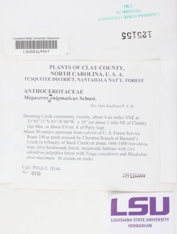
"dwc:startDayOfYear": "60",
"dwc:identificationRemarks": "with Phillip E. Hyatt",
"dwc:specificEpithet": "aenigmaticus",
"dwc:county": "Clay",
"dwc:recordedBy": "Philip E. Hyatt",
"dwc:order": "Dendrocerotales",
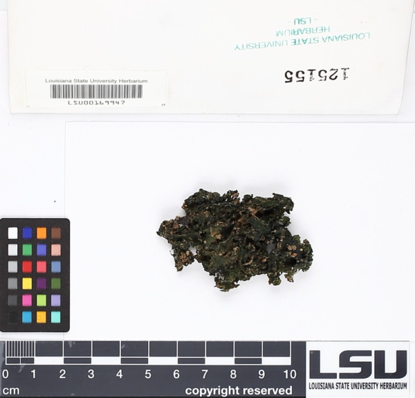
"dwc:habitat": "Cove hardwoods forest, streamsidc habitats with Liriodendron tulipifera forest with Tsuga canadensis and Rhododendron maximum.; In stream on rocks.",
"dwc:scientificNameAuthorship": "R.M. Schust.",
"dwc:georeferenceRemarks": "lat/long = on label",
"dwc:occurrenceID": "66fd04d5-4b5d-4335-a5a5-108d42dffbf3",
"dwc:dateIdentified": "s.d.",
"dcterms:language": "en",
"dwc:verbatimCoordinates": "35° 05' 15\" N 83° 38' 00\" W",
"dwc:verbatimElevation": "3440-3480 ft.",
"id": "1793563",
"dwc:taxonID": "159865",
"dwc:stateProvince": "North Carolina",
"dwc:eventDate": "2000-02-29",
"symbiota:recordEnteredBy": "mhebert",
"dwc:collectionID": "fce06a6b-7beb-4cd4-a8fa-f1a0f271ad1f",
"dwc:country": "United States",
"dwc:collectionCode": "Bryophytes",
"dwc:higherClassification": "Plantae|Bryobiotina|Anthocerotophyta|Anthocerotopsida|Dendrocerotidae|Dendrocerotales|Dendrocerotaceae|Megaceros",
"dwc:kingdom": "Plantae",
"dwc:decimalLatitude": "35.0875",
"dwc:occurrenceRemarks": "Also det. by Philip E. Hyatt.",
"dwc:maximumElevationInMeters": "1061",
"dwc:basisOfRecord": "PreservedSpecimen",
"dwc:genus": "Megaceros",
"dwc:family": "Dendrocerotaceae",
"dc:rights": "http://creativecommons.org/licenses/by-nc/3.0/",
"dwc:identifiedBy": "Gary Kauffman",
"symbiota:recordID": "66fd04d5-4b5d-4335-a5a5-108d42dffbf3",
"dwc:phylum": "Anthocerotophyta",
"dcterms:references": "https://bryophyteportal.org/portal/collections/individual/index.php?occid=1793563",
"dwc:locality": "TUSQUITEE DISTRICT. Nantahala National Forest. Shooting Creek community vicinity, about 1 mile NE of Chunky Gal Mtn. or about 0.9 mi. E of Perry Gap. About 80 meters upstream from culvert of U.S. Forest Service Road 350 at point crossed by Chestnut Branch of Barnard's Creek (tributary of Buck Creek).",
"dwc:institutionCode": "LSU",
"dwc:taxonRank": "Species",
"dwc:class": "Anthocerotopsida",
"dwc:catalogNumber": "LSU00169947",
"dwc:taxonRemarks": "hepatic",
"dwc:month": "2",
"dwc:decimalLongitude": "-83.633333",
"dwc:coordinateUncertaintyInMeters": "100",
"dwc:otherCatalogNumbers": "125155",
"dwc:georeferencedBy": "adurha5",
"dwc:verbatimEventDate": "29FEB2000",
"dwc:recordNumber": "8948",
"dwc:minimumElevationInMeters": "1049",
"dcterms:modified": "2022-07-11 06:38:43",
"dwc:scientificName": "Megaceros aenigmaticus",
"dwc:day": "29",
"dwc:year": "2000"
},
"indexTerms": {
"geopoint": {
"lat": 35.0875,
"lon": -83.633333
},
"family": "dendrocerotaceae",
"recordset": "8e5fffb5-0b22-472d-8386-de291d17d513",
"dqs": 0.4057971014492754,
"stateprovince": "north carolina",
"county": "clay",
"phylum": "anthocerotophyta",
"catalognumber": "lsu00169947",
"startdayofyear": 60,
"taxonrank": "species",
"specificepithet": "aenigmaticus",
"continent": "north america",
"uuid": "66fd04d5-4b5d-4335-a5a5-108d42dffbf3",
"countrycode": "usa",
"basisofrecord": "preservedspecimen",
"collector": "philip e. hyatt",
"institutioncode": "lsu",
"mediarecords": [
"fdde8c92-5176-410e-a9bb-fdd2291a7a93",
"61e6d331-dde2-4638-b671-7a9ced88211d"
],
"datemodified": "2023-01-11T03:53:53.499737+00:00",
"datecollected": "2000-02-29T00:00:00+00:00",
"etag": "9c79a31b6e82de71cdc9c3a2dc8081b49e6c89d3",
"recordnumber": "8948",
"minelevation": 1049,
"hasImage": true,
"kingdom": "plantae",
"maxelevation": 1061,
"highertaxon": "plantae|bryobiotina|anthocerotophyta|anthocerotopsida|dendrocerotidae|dendrocerotales|dendrocerotaceae|megaceros",
"collectionid": "fce06a6b-7beb-4cd4-a8fa-f1a0f271ad1f",
"taxonid": "5710307",
"scientificname": "megaceros aenigmaticus",
"indexData": {
"dwc:startDayOfYear": "60",
"dwc:identificationRemarks": "with Phillip E. Hyatt",
"dwc:specificEpithet": "aenigmaticus",
"idigbio:dateModified": "2023-01-11T03:53:53.499737",
"dwc:county": "Clay",
"dwc:recordedBy": "Philip E. Hyatt",
"idigbio:uuid": "66fd04d5-4b5d-4335-a5a5-108d42dffbf3",
"dwc:order": "Dendrocerotales",
"dwc:habitat": "Cove hardwoods forest, streamsidc habitats with Liriodendron tulipifera forest with Tsuga canadensis and Rhododendron maximum.; In stream on rocks.",
"dwc:datasetid": "d9a4eedb-e985-4456-ad46-3df8472e00e8",
"dwc:scientificNameAuthorship": "R.M. Schust.",
"flag_dwc_taxonid_replaced": true,
"dwc:occurrenceID": "66fd04d5-4b5d-4335-a5a5-108d42dffbf3",
"dwc:dateIdentified": "s.d.",
"flag_gbif_canonicalname_added": true,
"dcterms:language": "en",
"dwc:verbatimCoordinates": "35° 05' 15\" N 83° 38' 00\" W",
"dwc:verbatimElevation": "3440-3480 ft.",
"dwc:decimalLatitude": "35.0875",
"flag_gbif_genericname_added": true,
"symbiota:recordEnteredBy": "mhebert",
"dwc:taxonID": "5710307",
"idigbio:parent": "8e5fffb5-0b22-472d-8386-de291d17d513",
"dwc:stateProvince": "North Carolina",
"flag_gbif_taxon_corrected": true,
"dwc:eventDate": "2000-02-29",
"dwc:collectionID": "fce06a6b-7beb-4cd4-a8fa-f1a0f271ad1f",
"dwc:country": "United States",
"idigbio:etag": "9c79a31b6e82de71cdc9c3a2dc8081b49e6c89d3",
"dwc:collectionCode": "Bryophytes",
"id": "1793563",
"dwc:kingdom": "Plantae",
"dwc:georeferenceRemarks": "lat/long = on label",
"dwc:occurrenceRemarks": "Also det. by Philip E. Hyatt.",
"dwc:maximumElevationInMeters": "1061",
"dwc:basisOfRecord": "PreservedSpecimen",
"dwc:taxonomicstatus": "accepted",
"dwc:genus": "Megaceros",
"dwc:continent": "north america",
"dwc:family": "Dendrocerotaceae",
"dc:rights": "http://creativecommons.org/licenses/by-nc/3.0/",
"dwc:identifiedBy": "Gary Kauffman",
"flag_dwc_datasetid_added": true,
"dwc:class": "Anthocerotopsida",
"idigbio:siblings": {
"mediarecord": [
"fdde8c92-5176-410e-a9bb-fdd2291a7a93",
"61e6d331-dde2-4638-b671-7a9ced88211d"
]
},
"symbiota:recordID": "66fd04d5-4b5d-4335-a5a5-108d42dffbf3",
"flag_idigbio_isocountrycode_added": true,
"gbif:canonicalname": "megaceros aenigmaticus",
"dwc:phylum": "Anthocerotophyta",
"dcterms:references": "https://bryophyteportal.org/portal/collections/individual/index.php?occid=1793563",
"gbif:genericname": "megaceros",
"dwc:locality": "TUSQUITEE DISTRICT. Nantahala National Forest. Shooting Creek community vicinity, about 1 mile NE of Chunky Gal Mtn. or about 0.9 mi. E of Perry Gap. About 80 meters upstream from culvert of U.S. Forest Service Road 350 at point crossed by Chestnut Branch of Barnard's Creek (tributary of Buck Creek).",
"dwc:institutionCode": "LSU",
"dwc:taxonRank": "Species",
"dwc:parentnameusageid": "2689576",
"dwc:higherClassification": "Plantae|Bryobiotina|Anthocerotophyta|Anthocerotopsida|Dendrocerotidae|Dendrocerotales|Dendrocerotaceae|Megaceros",
"dwc:catalogNumber": "LSU00169947",
"dwc:taxonRemarks": "hepatic",
"dwc:month": "2",
"dwc:decimalLongitude": "-83.633333",
"dwc:scientificName": "Megaceros aenigmaticus",
"flag_dwc_taxonomicstatus_added": true,
"dwc:otherCatalogNumbers": "125155",
"dwc:georeferencedBy": "adurha5",
"dwc:verbatimEventDate": "29FEB2000",
"flag_dwc_continent_added": true,
"idigbio:recordIds": [
"urn:uuid:66fd04d5-4b5d-4335-a5a5-108d42dffbf3",
"8e5fffb5-0b22-472d-8386-de291d17d513\\urn:uuid:66fd04d5-4b5d-4335-a5a5-108d42dffbf3",
"8e5fffb5-0b22-472d-8386-de291d17d513\\1793563",
"8e5fffb5-0b22-472d-8386-de291d17d513\\66fd04d5-4b5d-4335-a5a5-108d42dffbf3"
],
"dwc:recordNumber": "8948",
"idigbio:isocountrycode": "usa",
"flag_dwc_parentnameusageid_added": true,
"dwc:minimumElevationInMeters": "1049",
"dcterms:modified": "2022-07-11 06:38:43",
"dwc:coordinateUncertaintyInMeters": "100",
"dwc:day": "29",
"dwc:year": "2000"
},
"hasMedia": true,
"coordinateuncertainty": 100,
"class": "anthocerotopsida",
"occurrenceid": "66fd04d5-4b5d-4335-a5a5-108d42dffbf3",
"country": "united states",
"locality": "tusquitee district. nantahala national forest. shooting creek community vicinity, about 1 mile ne of chunky gal mtn. or about 0.9 mi. e of perry gap. about 80 meters upstream from culvert of u.s. forest service road 350 at point crossed by chestnut branch of barnard's creek (tributary of buck creek).",
"collectioncode": "bryophytes",
"canonicalname": "megaceros aenigmaticus",
"eventdate": "2000-02-29",
"flags": [
"geopoint_datum_missing",
"dwc_taxonid_replaced",
"gbif_canonicalname_added",
"gbif_genericname_added",
"gbif_taxon_corrected",
"dwc_datasetid_added",
"idigbio_isocountrycode_added",
"dwc_taxonomicstatus_added",
"dwc_continent_added",
"dwc_parentnameusageid_added"
],
"verbatimeventdate": "29feb2000",
"taxonomicstatus": "accepted",
"recordids": [
"urn:uuid:66fd04d5-4b5d-4335-a5a5-108d42dffbf3",
"8e5fffb5-0b22-472d-8386-de291d17d513\\urn:uuid:66fd04d5-4b5d-4335-a5a5-108d42dffbf3",
"8e5fffb5-0b22-472d-8386-de291d17d513\\1793563",
"8e5fffb5-0b22-472d-8386-de291d17d513\\66fd04d5-4b5d-4335-a5a5-108d42dffbf3"
],
"genus": "megaceros",
"order": "dendrocerotales",
"datasetid": "d9a4eedb-e985-4456-ad46-3df8472e00e8"
},
"attribution": {
"totalCount": 9574
}
}