{
"uuid": "60726876-7d36-4c06-95f2-4d74b8a5cf24",
"type": "records",
"etag": "11068ecbc75d58ca86c57bbc4d998b592cf0d3a4",
"data": {
"dwc:startDayOfYear": "319",
"dwc:specificEpithet": "sangenidii",
"dwc:countryCode": "US",
"dwc:county": "Snohomish",
"dwc:recordedBy": "Elroy Burnett",
"dwc:georeferenceSources": "TRS2LL",
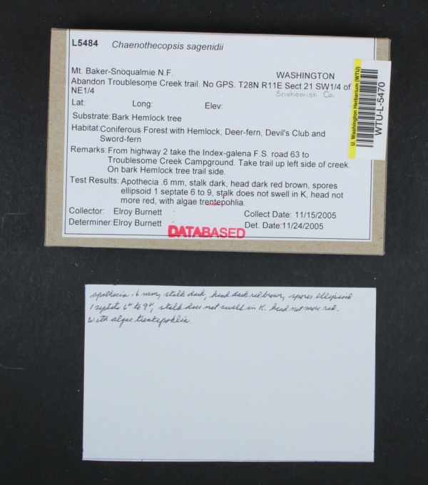
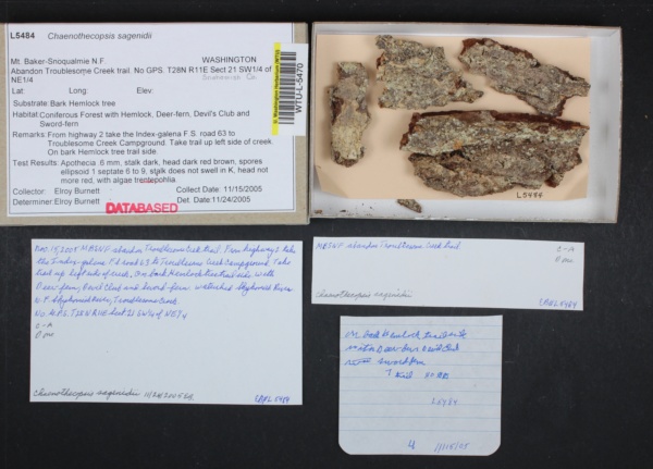
"dwc:habitat": "Coniferous forest with Hemlock, Deer-fern, Devil's Club and Sword Fern. On bark of Hemlock tree, trail side.",
"dwc:scientificNameAuthorship": "Tibell",
"dwc:occurrenceID": "ed723805-7e74-400a-8820-8d8541b4c882",
"dwc:dateIdentified": "2005-24",
"dcterms:language": "en",
"dwc:verbatimCoordinates": "T28N R11E S21 SW of NE",
"id": "606650",
"dwc:stateProvince": "Washington",
"dwc:eventDate": "2005-11-15",
"dwc:institutionCode": "WTU",
"dwc:country": "U.S.A.",
"idigbio:recordId": "DF93B120-F7F6-427D-B0FB-DF6EF5703415",
"dwc:collectionCode": "Lichens",
"dcterms:rightsHolder": "University of Washington",
"dwc:decimalLatitude": "47.9026",
"dwc:occurrenceRemarks": "Substrate: Bark Hemlock tree. Apothecia 0.6 millimeters, stalk dark, head dark red brown, spores ellipsoid 1 septate 6 to 9, with algae trentpohlia. Stalk does not swell in K, head not more red. Substrate: corticolous.",
"dwc:basisOfRecord": "PreservedSpecimen",
"dwc:genus": "Chaenothecopsis",
"dwc:family": "Mycocaliciaceae",
"dwc:identifiedBy": "Elroy Burnett",
"dcterms:license": "https://creativecommons.org/publicdomain/zero/1.0/",
"dwc:ownerInstitutionCode": "WTU",
"dwc:locality": "Mount Baker-Snoqualmie National Forest, Abandon Troublesome Creek Trail. From Highway 2 take the Galena-Index Forest Service Road 63 to Troublesome Creek Campground. Take trail up left side of creek. No GPS.",
"dwc:geodeticDatum": "NAD 27",
"dwc:taxonRank": "species",
"dwc:higherClassification": "Mycocaliciaceae",
"dwc:catalogNumber": "WTU-L-005470",
"dwc:nomenclaturalCode": "ICBN",
"dcterms:type": "PhysicalObject",
"dwc:Identification": [
{
"dwc:identifiedBy": "Elroy Burnett",
"dwc:nomenclaturalCode": "ICBN",
"dwc:genus": "Chaenothecopsis",
"dwc:specificEpithet": "sangenidii",
"coreid": "606650",
"dwc:scientificNameAuthorship": "Tibell",
"dwc:dateIdentified": "2005-24",
"dwc:taxonRank": "species",
"dwc:scientificName": "Chaenothecopsis sangenidii",
"dwc:higherClassification": "Mycocaliciaceae",
"dwc:family": "Mycocalicaceae"
}
],
"dwc:higherGeography": "U.S.A., Washington, Snohomish County",
"dwc:month": "11",
"dwc:decimalLongitude": "-121.3992",
"dwc:coordinateUncertaintyInMeters": "805",
"dwc:endDayOfYear": "319",
"dwc:georeferencedBy": "Ben Legler",
"dwc:recordNumber": "L5484",
"dcterms:modified": "2018-11-08T23:54:03-0800",
"dwc:scientificName": "Chaenothecopsis sangenidii",
"dwc:day": "15",
"dwc:year": "2005"
},
"indexTerms": {
"geopoint": {
"lat": 47.90246321849351,
"lon": -121.40041517086995
},
"family": "mycocaliciaceae",
"recordset": "9368e302-f8e7-4714-aed4-db2faa861e5c",
"dqs": 0.2753623188405797,
"stateprovince": "washington",
"county": "snohomish",
"phylum": "ascomycota",
"catalognumber": "wtu-l-005470",
"startdayofyear": 319,
"taxonrank": "species",
"specificepithet": "sagenidii",
"continent": "north america",
"uuid": "60726876-7d36-4c06-95f2-4d74b8a5cf24",
"countrycode": "usa",
"basisofrecord": "preservedspecimen",
"collector": "elroy burnett",
"institutioncode": "wtu",
"mediarecords": [
"3face2c3-b05f-4fc9-b5e3-34fa67eef5a7",
"73421913-d9bb-4712-b279-17675d5cabf2"
],
"datemodified": "2021-09-19T20:34:53.839221+00:00",
"datecollected": "2005-11-15T00:00:00+00:00",
"etag": "11068ecbc75d58ca86c57bbc4d998b592cf0d3a4",
"recordnumber": "l5484",
"hasImage": true,
"kingdom": "fungi",
"highertaxon": "mycocaliciaceae",
"taxonid": "3468621",
"scientificname": "chaenothecopsis sangenidii",
"indexData": {
"dwc:startDayOfYear": "319",
"flag_dwc_country_replaced": true,
"dwc:specificEpithet": "sagenidii",
"idigbio:dateModified": "2021-09-19T20:34:53.839221",
"dwc:countryCode": "US",
"dwc:county": "Snohomish",
"dwc:recordedBy": "Elroy Burnett",
"idigbio:uuid": "60726876-7d36-4c06-95f2-4d74b8a5cf24",
"dwc:locality": "Mount Baker-Snoqualmie National Forest, Abandon Troublesome Creek Trail. From Highway 2 take the Galena-Index Forest Service Road 63 to Troublesome Creek Campground. Take trail up left side of creek. No GPS.",
"dwc:order": "mycocaliciales",
"dwc:habitat": "Coniferous forest with Hemlock, Deer-fern, Devil's Club and Sword Fern. On bark of Hemlock tree, trail side.",
"flag_dwc_phylum_added": true,
"dwc:scientificNameAuthorship": "Tibell",
"idigbio:recordIds": [
"urn:uuid:60726876-7d36-4c06-95f2-4d74b8a5cf24",
"9368e302-f8e7-4714-aed4-db2faa861e5c\\1254235",
"9368e302-f8e7-4714-aed4-db2faa861e5c\\ed723805-7e74-400a-8820-8d8541b4c882",
"df93b120-f7f6-427d-b0fb-df6ef5703415",
"9368e302-f8e7-4714-aed4-db2faa861e5c\\606650"
],
"dwc:occurrenceID": "ed723805-7e74-400a-8820-8d8541b4c882",
"dwc:dateIdentified": "2005-24",
"flag_dwc_specificepithet_replaced": true,
"dcterms:language": "en",
"dwc:verbatimCoordinates": "T28N R11E S21 SW of NE",
"flag_dwc_taxonomicstatus_added": true,
"flag_gbif_genericname_added": true,
"dcterms:rightsHolder": "University of Washington",
"flag_dwc_datasetid_added": true,
"idigbio:parent": "9368e302-f8e7-4714-aed4-db2faa861e5c",
"dwc:stateProvince": "Washington",
"flag_gbif_taxon_corrected": true,
"dwc:datasetid": "a6c6cead-b5ce-4a4e-8cf5-1542ba708dec",
"dwc:eventDate": "2005-11-15",
"dwc:country": "united states",
"idigbio:recordId": "DF93B120-F7F6-427D-B0FB-DF6EF5703415",
"idigbio:etag": "11068ecbc75d58ca86c57bbc4d998b592cf0d3a4",
"dwc:collectionCode": "Lichens",
"id": "606650",
"dwc:kingdom": "fungi",
"dwc:decimalLatitude": "47.9026",
"dwc:occurrenceRemarks": "Substrate: Bark Hemlock tree. Apothecia 0.6 millimeters, stalk dark, head dark red brown, spores ellipsoid 1 septate 6 to 9, with algae trentpohlia. Stalk does not swell in K, head not more red. Substrate: corticolous.",
"dwc:basisOfRecord": "PreservedSpecimen",
"dwc:taxonomicstatus": "accepted",
"dwc:genus": "Chaenothecopsis",
"dwc:continent": "north america",
"dwc:family": "Mycocaliciaceae",
"flag_dwc_continent_added": true,
"dwc:identifiedBy": "Elroy Burnett",
"dwc:class": "eurotiomycetes",
"gbif:canonicalname": "chaenothecopsis sagenidii",
"flag_dwc_taxonid_added": true,
"dcterms:license": "https://creativecommons.org/publicdomain/zero/1.0/",
"idigbio:siblings": {
"mediarecord": [
"3face2c3-b05f-4fc9-b5e3-34fa67eef5a7",
"73421913-d9bb-4712-b279-17675d5cabf2"
]
},
"dwc:ownerInstitutionCode": "WTU",
"flag_idigbio_isocountrycode_added": true,
"dwc:phylum": "ascomycota",
"gbif:genericname": "chaenothecopsis",
"dwc:georeferenceSources": "TRS2LL",
"dwc:institutionCode": "WTU",
"dwc:taxonRank": "species",
"dwc:parentnameusageid": "2595699",
"dwc:higherClassification": "Mycocaliciaceae",
"dwc:catalogNumber": "WTU-L-005470",
"dwc:taxonid": "3468621",
"dwc:nomenclaturalCode": "ICBN",
"dcterms:type": "PhysicalObject",
"flag_gbif_canonicalname_added": true,
"dwc:Identification": [
{
"dwc:identifiedBy": "Elroy Burnett",
"dwc:nomenclaturalCode": "ICBN",
"dwc:taxonRank": "species",
"dwc:specificEpithet": "sangenidii",
"coreid": "606650",
"dwc:scientificNameAuthorship": "Tibell",
"dwc:dateIdentified": "2005-24",
"dwc:genus": "Chaenothecopsis",
"dwc:scientificName": "Chaenothecopsis sangenidii",
"dwc:higherClassification": "Mycocaliciaceae",
"dwc:family": "Mycocalicaceae"
}
],
"dwc:higherGeography": "U.S.A., Washington, Snohomish County",
"dwc:month": "11",
"dwc:decimalLongitude": "-121.3992",
"dwc:scientificName": "Chaenothecopsis sangenidii",
"dwc:endDayOfYear": "319",
"flag_dwc_order_added": true,
"dwc:georeferencedBy": "Ben Legler",
"dwc:recordNumber": "L5484",
"idigbio:isocountrycode": "usa",
"flag_dwc_parentnameusageid_added": true,
"flag_dwc_class_added": true,
"dwc:geodeticDatum": "NAD 27",
"dcterms:modified": "2018-11-08T23:54:03-0800",
"dwc:coordinateUncertaintyInMeters": "805",
"dwc:day": "15",
"flag_dwc_kingdom_added": true,
"dwc:year": "2005"
},
"hasMedia": true,
"coordinateuncertainty": 805,
"class": "eurotiomycetes",
"occurrenceid": "ed723805-7e74-400a-8820-8d8541b4c882",
"country": "united states",
"locality": "mount baker-snoqualmie national forest, abandon troublesome creek trail. from highway 2 take the galena-index forest service road 63 to troublesome creek campground. take trail up left side of creek. no gps.",
"collectioncode": "lichens",
"canonicalname": "chaenothecopsis sagenidii",
"eventdate": "2005-11-15",
"flags": [
"dwc_country_replaced",
"dwc_phylum_added",
"dwc_specificepithet_replaced",
"dwc_taxonomicstatus_added",
"gbif_genericname_added",
"dwc_datasetid_added",
"gbif_taxon_corrected",
"dwc_continent_added",
"dwc_taxonid_added",
"idigbio_isocountrycode_added",
"gbif_canonicalname_added",
"dwc_order_added",
"dwc_parentnameusageid_added",
"dwc_class_added",
"dwc_kingdom_added"
],
"taxonomicstatus": "accepted",
"recordids": [
"urn:uuid:60726876-7d36-4c06-95f2-4d74b8a5cf24",
"9368e302-f8e7-4714-aed4-db2faa861e5c\\1254235",
"9368e302-f8e7-4714-aed4-db2faa861e5c\\ed723805-7e74-400a-8820-8d8541b4c882",
"df93b120-f7f6-427d-b0fb-df6ef5703415",
"9368e302-f8e7-4714-aed4-db2faa861e5c\\606650"
],
"genus": "chaenothecopsis",
"order": "mycocaliciales",
"datasetid": "a6c6cead-b5ce-4a4e-8cf5-1542ba708dec"
},
"attribution": {
"totalCount": 32442
}
}