{
"uuid": "52629ec9-9a4e-4095-bcd8-de4fc7befc36",
"type": "records",
"etag": "967d94807bb3764da05a40684e94bdd45c2ebf70",
"data": {
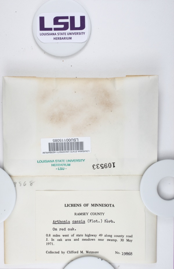
"dwc:startDayOfYear": "150",
"dwc:specificEpithet": "caesia",
"dwc:county": "Ramsey",
"dwc:recordedBy": "Clifford M. Wetmore",
"dwc:georeferenceSources": "2016-10-03; Google Maps",
"dwc:order": "Arthoniales",
"dwc:habitat": "In oak area and meadows near swamp.; On red oak.",
"dwc:scientificNameAuthorship": "(Flotow) Körb.",
"dwc:georeferenceRemarks": "lat/long = center of Ramsey County; uncertainty = extent of county; County Rd J not found",
"dwc:occurrenceID": "1ab949f5-b2b7-418c-8582-95dfb4733b18",
"id": "1523903",
"dwc:taxonID": "52404",
"dwc:stateProvince": "Minnesota",
"dwc:eventDate": "1971-05-30",
"dwc:collectionID": "277e00e1-6282-4ebb-a164-1733d04c99fc",
"dwc:institutionCode": "LSU",
"dwc:country": "United States",
"dwc:collectionCode": "Lichens",
"dwc:higherClassification": "Fungi|Dikarya|Ascomycota|Pezizomycotina|Arthoniomycetes|Arthoniomycetidae|Arthoniales|Arthoniaceae|Arthonia",
"dwc:kingdom": "Fungi",
"dwc:decimalLatitude": "45.008307",
"dwc:occurrenceRemarks": "no ascocarps; rough crust",
"dwc:basisOfRecord": "PreservedSpecimen",
"dwc:genus": "Arthonia",
"dwc:family": "Arthoniaceae",
"dc:rights": "http://creativecommons.org/licenses/by-nc/3.0/",
"symbiota:recordID": "1ab949f5-b2b7-418c-8582-95dfb4733b18",
"dwc:phylum": "Ascomycota",
"dcterms:references": "https://lichenportal.org/cnalh/collections/individual/index.php?occid=1523903",
"dwc:locality": "0.8 miles west of state highway 49 along county road J.",
"dwc:geodeticDatum": "WGS84",
"dwc:taxonRank": "Species",
"dwc:class": "Arthoniomycetes",
"dwc:catalogNumber": "LSU00115085",
"dwc:month": "5",
"dwc:decimalLongitude": "-93.093938",
"dwc:coordinateUncertaintyInMeters": "17430",
"dwc:otherCatalogNumbers": "109533",
"dwc:georeferencedBy": "cmozzicato (2016-10-03 13:13:20)",
"dwc:verbatimEventDate": "5/30/1971",
"dwc:recordNumber": "19868",
"dcterms:modified": "2021-03-16 11:09:31",
"dwc:scientificName": "Arthonia caesia",
"dwc:day": "30",
"dwc:year": "1971"
},
"indexTerms": {
"geopoint": {
"lat": 45.008307,
"lon": -93.093938
},
"family": "arthoniaceae",
"recordset": "40987883-03cf-494a-a5cf-7c77c7aadb79",
"dqs": 0.36231884057971014,
"stateprovince": "minnesota",
"county": "ramsey",
"phylum": "ascomycota",
"catalognumber": "lsu00115085",
"startdayofyear": 150,
"taxonrank": "species",
"specificepithet": "caesia",
"continent": "north america",
"uuid": "52629ec9-9a4e-4095-bcd8-de4fc7befc36",
"countrycode": "usa",
"basisofrecord": "preservedspecimen",
"collector": "clifford m. wetmore",
"institutioncode": "lsu",
"mediarecords": [
"a2e5a406-7623-4afc-a6b4-52bd03f25325"
],
"datemodified": "2023-01-11T04:10:46.760978+00:00",
"datecollected": "1971-05-30T00:00:00+00:00",
"etag": "967d94807bb3764da05a40684e94bdd45c2ebf70",
"recordnumber": "19868",
"hasImage": true,
"kingdom": "fungi",
"highertaxon": "fungi|dikarya|ascomycota|pezizomycotina|arthoniomycetes|arthoniomycetidae|arthoniales|arthoniaceae|arthonia",
"collectionid": "277e00e1-6282-4ebb-a164-1733d04c99fc",
"taxonid": "7729744",
"scientificname": "arthonia caesia",
"indexData": {
"dwc:startDayOfYear": "150",
"dwc:specificEpithet": "caesia",
"idigbio:dateModified": "2023-01-11T04:10:46.760978",
"dwc:county": "Ramsey",
"dwc:recordedBy": "Clifford M. Wetmore",
"idigbio:uuid": "52629ec9-9a4e-4095-bcd8-de4fc7befc36",
"dwc:locality": "0.8 miles west of state highway 49 along county road J.",
"dwc:order": "Arthoniales",
"dwc:habitat": "In oak area and meadows near swamp.; On red oak.",
"dwc:scientificNameAuthorship": "körb. (flotow)",
"flag_dwc_taxonid_replaced": true,
"dwc:occurrenceID": "1ab949f5-b2b7-418c-8582-95dfb4733b18",
"dwc:decimalLatitude": "45.008307",
"flag_gbif_genericname_added": true,
"id": "1523903",
"dwc:taxonID": "7729744",
"idigbio:parent": "40987883-03cf-494a-a5cf-7c77c7aadb79",
"dwc:stateProvince": "Minnesota",
"flag_gbif_taxon_corrected": true,
"dwc:eventDate": "1971-05-30",
"flag_dwc_scientificnameauthorship_replaced": true,
"dwc:collectionID": "277e00e1-6282-4ebb-a164-1733d04c99fc",
"dwc:country": "United States",
"idigbio:etag": "967d94807bb3764da05a40684e94bdd45c2ebf70",
"dwc:collectionCode": "Lichens",
"dwc:class": "Arthoniomycetes",
"dwc:kingdom": "Fungi",
"dwc:georeferenceRemarks": "lat/long = center of Ramsey County; uncertainty = extent of county; County Rd J not found",
"dwc:occurrenceRemarks": "no ascocarps; rough crust",
"dwc:basisOfRecord": "PreservedSpecimen",
"dwc:taxonomicstatus": "accepted",
"dwc:genus": "Arthonia",
"dwc:continent": "north america",
"dwc:family": "Arthoniaceae",
"dc:rights": "http://creativecommons.org/licenses/by-nc/3.0/",
"flag_dwc_parentnameusageid_added": true,
"flag_dwc_datasetid_added": true,
"idigbio:isocountrycode": "usa",
"dwc:geodeticDatum": "WGS84",
"idigbio:siblings": {
"mediarecord": [
"a2e5a406-7623-4afc-a6b4-52bd03f25325"
]
},
"symbiota:recordID": "1ab949f5-b2b7-418c-8582-95dfb4733b18",
"flag_idigbio_isocountrycode_added": true,
"gbif:canonicalname": "arthonia caesia",
"dwc:phylum": "Ascomycota",
"dcterms:references": "https://lichenportal.org/cnalh/collections/individual/index.php?occid=1523903",
"gbif:genericname": "arthonia",
"dwc:georeferenceSources": "2016-10-03; Google Maps",
"dwc:institutionCode": "LSU",
"dwc:taxonRank": "Species",
"dwc:parentnameusageid": "2581942",
"dwc:higherClassification": "Fungi|Dikarya|Ascomycota|Pezizomycotina|Arthoniomycetes|Arthoniomycetidae|Arthoniales|Arthoniaceae|Arthonia",
"dwc:catalogNumber": "LSU00115085",
"flag_gbif_canonicalname_added": true,
"dwc:month": "5",
"dwc:decimalLongitude": "-93.093938",
"dwc:scientificName": "Arthonia caesia",
"flag_dwc_taxonomicstatus_added": true,
"dwc:otherCatalogNumbers": "109533",
"dwc:georeferencedBy": "cmozzicato (2016-10-03 13:13:20)",
"dwc:verbatimEventDate": "5/30/1971",
"flag_dwc_continent_added": true,
"idigbio:recordIds": [
"urn:uuid:1ab949f5-b2b7-418c-8582-95dfb4733b18",
"40987883-03cf-494a-a5cf-7c77c7aadb79\\1523903",
"40987883-03cf-494a-a5cf-7c77c7aadb79\\urn:uuid:1ab949f5-b2b7-418c-8582-95dfb4733b18",
"40987883-03cf-494a-a5cf-7c77c7aadb79\\1ab949f5-b2b7-418c-8582-95dfb4733b18"
],
"dwc:recordNumber": "19868",
"dwc:datasetid": "a6c6cead-b5ce-4a4e-8cf5-1542ba708dec",
"flag_taxon_match_failed": true,
"dcterms:modified": "2021-03-16 11:09:31",
"dwc:coordinateUncertaintyInMeters": "17430",
"dwc:day": "30",
"dwc:year": "1971"
},
"hasMedia": true,
"coordinateuncertainty": 17430,
"class": "arthoniomycetes",
"occurrenceid": "1ab949f5-b2b7-418c-8582-95dfb4733b18",
"country": "united states",
"locality": "0.8 miles west of state highway 49 along county road j.",
"collectioncode": "lichens",
"canonicalname": "arthonia caesia",
"eventdate": "1971-05-30",
"flags": [
"dwc_taxonid_replaced",
"gbif_genericname_added",
"gbif_taxon_corrected",
"dwc_scientificnameauthorship_replaced",
"dwc_parentnameusageid_added",
"dwc_datasetid_added",
"idigbio_isocountrycode_added",
"gbif_canonicalname_added",
"dwc_taxonomicstatus_added",
"dwc_continent_added",
"taxon_match_failed"
],
"verbatimeventdate": "5/30/1971",
"taxonomicstatus": "accepted",
"recordids": [
"urn:uuid:1ab949f5-b2b7-418c-8582-95dfb4733b18",
"40987883-03cf-494a-a5cf-7c77c7aadb79\\1523903",
"40987883-03cf-494a-a5cf-7c77c7aadb79\\urn:uuid:1ab949f5-b2b7-418c-8582-95dfb4733b18",
"40987883-03cf-494a-a5cf-7c77c7aadb79\\1ab949f5-b2b7-418c-8582-95dfb4733b18"
],
"genus": "arthonia",
"order": "arthoniales",
"datasetid": "a6c6cead-b5ce-4a4e-8cf5-1542ba708dec"
},
"attribution": {
"totalCount": 40643
}
}