{
"uuid": "4912c01a-e3f8-4cd5-bb31-70c2b45ddda9",
"type": "records",
"etag": "b5b99bfc056d8f01d1b15e364becac24b57a8b1a",
"data": {
"dwc:startDayOfYear": "294",
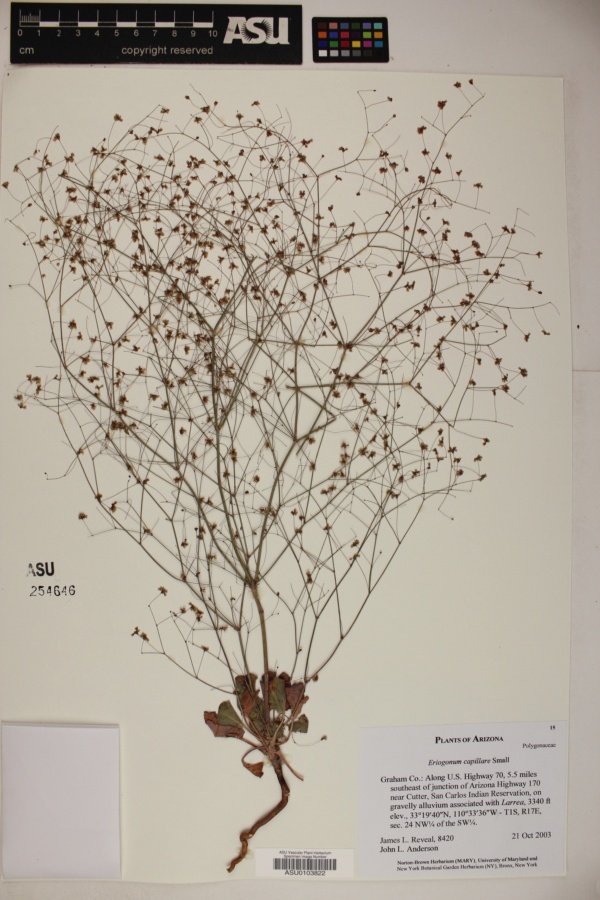
"dwc:specificEpithet": "capillare",
"dwc:county": "Graham County",
"dwc:recordedBy": "James L. Reveal; John L. Anderson",
"dwc:order": "Caryophyllales",
"dwc:habitat": "on gravelly alluvium",
"dwc:scientificNameAuthorship": "Small",
"dwc:occurrenceID": "61972b0c-f6e3-4bd4-8bce-ec290eb73196",
"id": "753488",
"dwc:taxonID": "3437",
"dwc:stateProvince": "Arizona",
"dwc:eventDate": "2003-10-21",
"dwc:collectionID": "a2e32c87-d320-4a01-bafd-a9182ae2e191",
"dwc:country": "USA",
"dwc:collectionCode": "Plants",
"symbiota:recordEnteredBy": "Liz",
"dwc:kingdom": "Plantae",
"dwc:decimalLatitude": "33.29",
"dwc:basisOfRecord": "PreservedSpecimen",
"dwc:genus": "Eriogonum",
"dwc:family": "Polygonaceae",
"dc:rights": "http://creativecommons.org/licenses/by-nc/3.0/",
"dwc:coordinateUncertaintyInMeters": "100",
"symbiota:recordID": "61972b0c-f6e3-4bd4-8bce-ec290eb73196",
"dwc:phylum": "Magnoliophyta",
"dcterms:references": "https://swbiodiversity.org/seinet/collections/individual/index.php?occid=753488",
"dwc:locality": "Along U.S. Highway 70 near 5.5 miles southeast of junction of Arizona Highway 170 near Cutter, San Carlos Indian Reservation",
"dwc:institutionCode": "ASU",
"dwc:taxonRank": "Species",
"dwc:higherClassification": "Plantae|Magnoliophyta|Eudicots|Core Eudicots|Caryophyllales|Polygonaceae|Eriogonum",
"dwc:catalogNumber": "ASU0103822",
"dwc:month": "10",
"dwc:decimalLongitude": "-110.36",
"dwc:scientificName": "Eriogonum capillare",
"dwc:otherCatalogNumbers": "254646",
"dwc:minimumElevationInMeters": "943",
"dcterms:modified": "2018-03-12 17:05:42",
"dwc:associatedTaxa": "ecologicallyOccursWith: Larrea",
"dwc:day": "21",
"dwc:year": "2003"
},
"indexTerms": {
"geopoint": {
"lat": 33.29,
"lon": -110.36
},
"family": "polygonaceae",
"recordset": "40250f4d-7aa6-4fcc-ac38-2868fa4846bd",
"dqs": 0.2753623188405797,
"stateprovince": "arizona",
"county": "graham county",
"phylum": "tracheophyta",
"catalognumber": "asu0103822",
"startdayofyear": 294,
"taxonrank": "species",
"specificepithet": "capillare",
"continent": "north america",
"uuid": "4912c01a-e3f8-4cd5-bb31-70c2b45ddda9",
"countrycode": "usa",
"basisofrecord": "preservedspecimen",
"collector": "james l. reveal; john l. anderson",
"institutioncode": "asu",
"mediarecords": [
"03fcf104-2dbe-472f-a04e-1bcfe57e8dfe"
],
"datemodified": "2022-12-06T21:46:35.594653+00:00",
"datecollected": "2003-10-21T00:00:00+00:00",
"etag": "b5b99bfc056d8f01d1b15e364becac24b57a8b1a",
"hasMedia": true,
"minelevation": 943,
"hasImage": true,
"kingdom": "plantae",
"highertaxon": "plantae|magnoliophyta|eudicots|core eudicots|caryophyllales|polygonaceae|eriogonum",
"collectionid": "a2e32c87-d320-4a01-bafd-a9182ae2e191",
"taxonid": "2889428",
"scientificname": "eriogonum capillare",
"indexData": {
"dwc:startDayOfYear": "294",
"dwc:specificEpithet": "capillare",
"idigbio:dateModified": "2022-12-06T21:46:35.594653",
"dwc:county": "Graham County",
"dwc:recordedBy": "James L. Reveal; John L. Anderson",
"idigbio:uuid": "4912c01a-e3f8-4cd5-bb31-70c2b45ddda9",
"dwc:order": "Caryophyllales",
"dwc:habitat": "on gravelly alluvium",
"flag_gbif_reference_added": true,
"dwc:scientificNameAuthorship": "Small",
"flag_dwc_taxonid_replaced": true,
"dwc:occurrenceID": "61972b0c-f6e3-4bd4-8bce-ec290eb73196",
"gbif:vernacularname": [
{
"coreid": "2889428",
"dcterms:source": "catalogue of life",
"dwc:vernacularname": "san carlos buckwheat"
},
{
"coreid": "2889428",
"dcterms:language": "en",
"dcterms:source": "integrated taxonomic information system (itis)",
"dwc:vernacularname": "san carlos buckwheat"
},
{
"coreid": "2889428",
"dcterms:language": "en",
"dcterms:source": "integrated taxonomic information system (itis)",
"dwc:vernacularname": "san carlos wild-buckwheat"
}
],
"flag_dwc_taxonomicstatus_added": true,
"flag_gbif_genericname_added": true,
"symbiota:recordEnteredBy": "Liz",
"dwc:taxonID": "2889428",
"idigbio:parent": "40250f4d-7aa6-4fcc-ac38-2868fa4846bd",
"dwc:stateProvince": "Arizona",
"flag_gbif_taxon_corrected": true,
"dwc:datasetid": "7ddf754f-d193-4cc9-b351-99906754a03b",
"dwc:eventDate": "2003-10-21",
"dwc:collectionID": "a2e32c87-d320-4a01-bafd-a9182ae2e191",
"dwc:country": "united states",
"idigbio:etag": "b5b99bfc056d8f01d1b15e364becac24b57a8b1a",
"dwc:collectionCode": "Plants",
"id": "753488",
"dwc:kingdom": "Plantae",
"dwc:decimalLatitude": "33.29",
"dwc:basisOfRecord": "PreservedSpecimen",
"dwc:taxonomicstatus": "accepted",
"dwc:genus": "Eriogonum",
"dwc:continent": "north america",
"dwc:family": "Polygonaceae",
"dc:rights": "http://creativecommons.org/licenses/by-nc/3.0/",
"flag_dwc_country_replaced": true,
"flag_dwc_datasetid_added": true,
"dwc:class": "magnoliopsida",
"dwc:associatedTaxa": "ecologicallyOccursWith: Larrea",
"idigbio:siblings": {
"mediarecord": [
"03fcf104-2dbe-472f-a04e-1bcfe57e8dfe"
]
},
"symbiota:recordID": "61972b0c-f6e3-4bd4-8bce-ec290eb73196",
"flag_idigbio_isocountrycode_added": true,
"gbif:canonicalname": "eriogonum capillare",
"dwc:phylum": "tracheophyta",
"dcterms:references": "https://swbiodiversity.org/seinet/collections/individual/index.php?occid=753488",
"gbif:genericname": "eriogonum",
"dwc:locality": "Along U.S. Highway 70 near 5.5 miles southeast of junction of Arizona Highway 170 near Cutter, San Carlos Indian Reservation",
"flag_gbif_vernacularname_added": true,
"dwc:institutionCode": "ASU",
"dwc:taxonRank": "Species",
"dwc:parentnameusageid": "8381158",
"dwc:higherClassification": "Plantae|Magnoliophyta|Eudicots|Core Eudicots|Caryophyllales|Polygonaceae|Eriogonum",
"dwc:catalogNumber": "ASU0103822",
"flag_dwc_phylum_replaced": true,
"flag_gbif_canonicalname_added": true,
"dwc:month": "10",
"dwc:decimalLongitude": "-110.36",
"dwc:scientificName": "Eriogonum capillare",
"dwc:otherCatalogNumbers": "254646",
"gbif:reference": [
{
"coreid": "2889428",
"dcterms:source": "catalogue of life",
"dcterms:bibliographiccitation": "small (1898) in: bull. torr. bot. club, 51"
},
{
"coreid": "2889428",
"dcterms:source": "the plant list with literature",
"dcterms:bibliographiccitation": "small jk (1898) studies in north american polygonaceae.-i. bulletin of the torrey botanical club 25: 40-53. doi: 10.2307/2478010."
}
],
"flag_dwc_continent_added": true,
"idigbio:recordIds": [
"urn:uuid:61972b0c-f6e3-4bd4-8bce-ec290eb73196",
"40250f4d-7aa6-4fcc-ac38-2868fa4846bd\\urn:uuid:61972b0c-f6e3-4bd4-8bce-ec290eb73196",
"40250f4d-7aa6-4fcc-ac38-2868fa4846bd\\753488",
"40250f4d-7aa6-4fcc-ac38-2868fa4846bd\\61972b0c-f6e3-4bd4-8bce-ec290eb73196"
],
"idigbio:isocountrycode": "usa",
"flag_dwc_parentnameusageid_added": true,
"flag_dwc_class_added": true,
"dwc:minimumElevationInMeters": "943",
"dcterms:modified": "2018-03-12 17:05:42",
"dwc:coordinateUncertaintyInMeters": "100",
"dwc:day": "21",
"dwc:year": "2003"
},
"coordinateuncertainty": 100,
"class": "magnoliopsida",
"occurrenceid": "61972b0c-f6e3-4bd4-8bce-ec290eb73196",
"country": "united states",
"locality": "along u.s. highway 70 near 5.5 miles southeast of junction of arizona highway 170 near cutter, san carlos indian reservation",
"collectioncode": "plants",
"canonicalname": "eriogonum capillare",
"eventdate": "2003-10-21",
"flags": [
"geopoint_datum_missing",
"geopoint_low_precision",
"gbif_reference_added",
"dwc_taxonid_replaced",
"dwc_taxonomicstatus_added",
"gbif_genericname_added",
"gbif_taxon_corrected",
"dwc_country_replaced",
"dwc_datasetid_added",
"idigbio_isocountrycode_added",
"gbif_vernacularname_added",
"dwc_phylum_replaced",
"gbif_canonicalname_added",
"dwc_continent_added",
"dwc_parentnameusageid_added",
"dwc_class_added"
],
"taxonomicstatus": "accepted",
"recordids": [
"urn:uuid:61972b0c-f6e3-4bd4-8bce-ec290eb73196",
"40250f4d-7aa6-4fcc-ac38-2868fa4846bd\\urn:uuid:61972b0c-f6e3-4bd4-8bce-ec290eb73196",
"40250f4d-7aa6-4fcc-ac38-2868fa4846bd\\753488",
"40250f4d-7aa6-4fcc-ac38-2868fa4846bd\\61972b0c-f6e3-4bd4-8bce-ec290eb73196"
],
"genus": "eriogonum",
"order": "caryophyllales",
"datasetid": "7ddf754f-d193-4cc9-b351-99906754a03b"
},
"attribution": {
"totalCount": 283567
}
}