{
"uuid": "46cd0f53-962a-4cf2-bd69-58d8bea70ca7",
"type": "records",
"etag": "c3e2e2fe3c95804026f4e3ae10d8bf3c6c002198",
"data": {
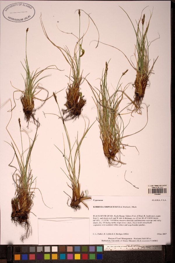
"dwc:identificationRemarks": "Former nature_of_id: legacy.",
"dwc:specificEpithet": "simpliciuscula",
"dwc:identificationVerificationStatus": "unknown",
"dwc:kingdom": "Plantae",
"dwc:recordedBy": "Collector(s): Carolyn L. Parker, Rob Lipkin, Jim Herriges",
"dwc:georeferencedDate": "2007-12-03 00:00:00",
"dwc:order": "Poales",
"dwc:habitat": "massive dolomite and limestone outcrops and rocky slopes, dry, SE-facing rubble slope above creek, Dryas heath-mixed herb vegetation with scattered white spruce and large boulder patches",
"dcterms:accessRights": "http://vertnet.org/resources/norms.html",
"dwc:occurrenceID": "http://arctos.database.museum/guid/UAM:Herb:130119?seid=1752611",
"dwc:dateIdentified": "2007-06-10",
"dwc:verbatimCoordinates": "66.8/-141.083333",
"dwc:verbatimEventDate": "10-Jun-2007",
"id": "http://arctos.database.museum/guid/UAM:Herb:130119?seid=1752611",
"dwc:establishmentMeans": "wild",
"dwc:minimumElevationInMeters": "714",
"dwc:stateProvince": "Alaska",
"dwc:eventDate": "2007-06-10",
"dwc:collectionID": "6",
"dwc:institutionCode": "UAM",
"dwc:country": "United States",
"dwc:collectionCode": "Herb",
"dwc:higherClassification": "Plantae, Tracheophyta, Liliopsida, Poales, Cyperaceae, Kobresia,",
"dwc:decimalLatitude": "66.8000000000",
"dwc:georeferenceVerificationStatus": "unverified",
"dwc:maximumElevationInMeters": "950",
"dwc:basisOfRecord": "PreservedSpecimen",
"dwc:genus": "Kobresia",
"dwc:family": "Cyperaceae",
"dwc:identificationQualifier": "A",
"dwc:identifiedBy": "unknown",
"dwc:dynamicProperties": "number of labels=2",
"dwc:georeferenceSources": "unknown",
"dwc:previousIdentifications": "[{\"scientific_name\":\"Kobresia simpliciuscula\",\"nature_of_id\":\"unknown\",\"accepted_id_fg\":1,\"made_date\":\"2007-06-10\",\"short_citation\":null,\"publication_id\":null,\"identification_remarks\":\"Former nature_of_id: legacy.\",\"idby\":\"unknown\",\"concept_label\":null}]",
"dwc:organismID": "http://arctos.database.museum/guid/UAM:Herb:130119",
"dwc:phylum": "Tracheophyta",
"dcterms:references": "http://arctos.database.museum/guid/UAM:Herb:130119",
"dwc:locationAccordingTo": "unknown",
"dwc:locality": "Keele Range, Salmon Fork of Black R. headwaters, upper Fort Cr. and slopes on E and W side of drainage, ca. 4.5 km SE of VABM Storm, Black River Quad",
"dwc:institutionID": "UAM",
"dwc:associatedMedia": "http://arctos.database.museum/MediaSearch.cfm?collection_object_id=2741087",
"dwc:geodeticDatum": "unknown",
"dwc:taxonRank": "species",
"dwc:class": "Liliopsida",
"dwc:catalogNumber": "UAM:Herb:130119",
"dwc:nomenclaturalCode": "ICBN",
"dwc:higherGeography": "United States, Alaska",
"dwc:endDayOfYear": "161",
"dwc:decimalLongitude": "-141.0833330000",
"dwc:month": "06",
"dwc:otherCatalogNumbers": "ALAAC=V160882, other identifier=16924",
"dwc:verbatimLocality": "Keele Range, Salmon Fork of Black R. headwaters, upper Fort Cr. and slopes on E and W side of drainage, ca. 4.5 km SE of VABM Storm",
"dwc:georeferencedBy": "unknown",
"dwc:day": "10",
"dwc:eventTime": "2007-06-10",
"dwc:preparations": "whole organism",
"dwc:verbatimCoordinateSystem": "decimal degrees",
"dwc:georeferenceProtocol": "not recorded",
"dcterms:modified": "2022-10-25 11:04:27.376775",
"dwc:scientificName": "Kobresia simpliciuscula",
"dwc:footprintWKT": "POLYGON((-141.083321626128 66.8000000059957,-141.083321841708 66.7999991308358,-141.083322486094 66.7999982890774,-141.083323534524 66.7999975130687,-141.083324946707 66.7999968326315,-141.083326668374 66.7999962739145,-141.083328633361 66.7999958583888,-141.083330766155 66.7999956020229,-141.083332984795 66.7999955146687,-141.083335204019 66.7999955996833,-141.083337338544 66.7999958537996,-141.083339306341 66.799996267252,-141.08334103179 66.7999968241518,-141.083342448581 66.7999975030976,-141.083343502268 66.799998277998,-141.08334415236 66.799999119074,-141.083344373872 66.7999999940035,-141.083344158293 66.8000008691634,-141.083343513907 66.8000017109219,-141.083342465477 66.8000024869307,-141.083341053295 66.800003167368,-141.083339331628 66.8000037260853,-141.083337366641 66.8000041416111,-141.083335233845 66.8000043979771,-141.083333015205 66.8000044853312,-141.08333079598 66.8000044003166,-141.083328661454 66.8000041462003,-141.083326693657 66.8000037327478,-141.083324968208 66.8000031758478,-141.083323551417 66.8000024969018,-141.08332249773 66.8000017220013,-141.083321847639 66.8000008809252,-141.083321626128 66.8000000059957))",
"dwc:year": "2007"
},
"indexTerms": {
"geopoint": {
"lat": 66.8,
"lon": -141.083333
},
"family": "cyperaceae",
"recordset": "b6ec6203-09db-4d6e-8cba-ee4bebd2934c",
"dqs": 0.3188405797101449,
"stateprovince": "alaska",
"phylum": "tracheophyta",
"catalognumber": "uam:herb:130119",
"startdayofyear": 161,
"taxonrank": "species",
"specificepithet": "simpliciuscula",
"continent": "north america",
"datemodified": "2022-12-07T00:58:43.563713+00:00",
"uuid": "46cd0f53-962a-4cf2-bd69-58d8bea70ca7",
"countrycode": "usa",
"basisofrecord": "preservedspecimen",
"collector": "collector(s): carolyn l. parker, rob lipkin, jim herriges",
"institutioncode": "uam",
"mediarecords": [
"12c24bd5-80e1-407f-98e8-7f12085300c9",
"a02e3e18-09df-4ba8-9809-d51955019aa6"
],
"verbatimlocality": "keele range, salmon fork of black r. headwaters, upper fort cr. and slopes on e and w side of drainage, ca. 4.5 km se of vabm storm",
"datecollected": "2007-06-10T00:00:00+00:00",
"etag": "c3e2e2fe3c95804026f4e3ae10d8bf3c6c002198",
"hasMedia": true,
"minelevation": 714,
"hasImage": true,
"kingdom": "plantae",
"maxelevation": 950,
"highertaxon": "plantae, tracheophyta, liliopsida, poales, cyperaceae, kobresia,",
"collectionid": "6",
"taxonid": "2710388",
"scientificname": "kobresia simpliciuscula",
"indexData": {
"dwc:georeferenceSources": "unknown",
"flag_gbif_reference_added": true,
"flag_gbif_genericname_added": true,
"flag_dwc_datasetid_added": true,
"idigbio:parent": "b6ec6203-09db-4d6e-8cba-ee4bebd2934c",
"dwc:country": "United States",
"flag_gbif_vernacularname_added": true,
"dwc:maximumElevationInMeters": "950",
"dwc:family": "Cyperaceae",
"dwc:geodeticDatum": "unknown",
"dwc:nomenclaturalCode": "ICBN",
"dwc:verbatimCoordinateSystem": "decimal degrees",
"gbif:reference": [
{
"coreid": "2710388",
"dcterms:source": "catalogue of life",
"dcterms:bibliographiccitation": "mack. (1923) in: bull. torrey bot. club 50: 349"
},
{
"coreid": "2710388",
"dcterms:source": "the plant list with literature",
"dcterms:bibliographiccitation": "mackenzie kk (1923) notes on carex-xiii. bulletin of the torrey botanical club 50: 343-358. doi: 10.2307/2479915."
}
],
"gbif:vernacularname": [
{
"coreid": "2710388",
"dcterms:language": "en",
"dcterms:source": "grin taxonomy",
"dwc:vernacularname": "false sedge"
},
{
"dwc:countrycode": "de",
"dwc:country": "germany",
"dwc:vernacularname": "schuppenried",
"coreid": "2710388",
"dcterms:source": "taxon list of vascular plants from bavaria, germany compiled in the context of the bfl project",
"dcterms:language": "de"
},
{
"coreid": "2710388",
"dcterms:language": "de",
"dcterms:source": "the european nature information system (eunis)",
"dwc:vernacularname": "schuppenried"
},
{
"coreid": "2710388",
"dcterms:language": "en",
"dcterms:source": "integrated taxonomic information system (itis)",
"dwc:vernacularname": "simple bog sedge"
},
{
"coreid": "2710388",
"dcterms:language": "de",
"dcterms:source": "german wikipedia - species pages",
"dwc:vernacularname": "zweiteilige schuppensegge"
}
],
"dwc:identificationRemarks": "Former nature_of_id: legacy.",
"dwc:recordedBy": "Collector(s): Carolyn L. Parker, Rob Lipkin, Jim Herriges",
"dwc:order": "Poales",
"dcterms:references": "http://arctos.database.museum/guid/UAM:Herb:130119",
"dcterms:accessRights": "http://vertnet.org/resources/norms.html",
"dwc:dateIdentified": "2007-06-10",
"flag_dwc_taxonomicstatus_added": true,
"dwc:establishmentMeans": "wild",
"dwc:basisOfRecord": "PreservedSpecimen",
"dwc:taxonomicstatus": "accepted",
"dwc:identificationQualifier": "A",
"dwc:dynamicProperties": "number of labels=2",
"dwc:previousIdentifications": "[{\"scientific_name\":\"Kobresia simpliciuscula\",\"nature_of_id\":\"unknown\",\"accepted_id_fg\":1,\"made_date\":\"2007-06-10\",\"short_citation\":null,\"publication_id\":null,\"identification_remarks\":\"Former nature_of_id: legacy.\",\"idby\":\"unknown\",\"concept_label\":null}]",
"flag_dwc_multimedia_added": true,
"dwc:associatedMedia": "http://arctos.database.museum/MediaSearch.cfm?collection_object_id=2741087",
"dwc:institutionCode": "UAM",
"flag_gbif_taxon_corrected": true,
"dwc:parentnameusageid": "2710236",
"dwc:class": "Liliopsida",
"dwc:taxonid": "2710388",
"flag_gbif_canonicalname_added": true,
"dwc:verbatimLocality": "Keele Range, Salmon Fork of Black R. headwaters, upper Fort Cr. and slopes on E and W side of drainage, ca. 4.5 km SE of VABM Storm",
"dwc:day": "10",
"dwc:minimumElevationInMeters": "714",
"dwc:scientificName": "Kobresia simpliciuscula",
"dwc:verbatimCoordinates": "66.8/-141.083333",
"idigbio:dateModified": "2022-12-07T00:58:43.563713",
"idigbio:uuid": "46cd0f53-962a-4cf2-bd69-58d8bea70ca7",
"dwc:georeferencedDate": "2007-12-03 00:00:00",
"gbif:canonicalname": "kobresia simpliciuscula",
"dwc:habitat": "massive dolomite and limestone outcrops and rocky slopes, dry, SE-facing rubble slope above creek, Dryas heath-mixed herb vegetation with scattered white spruce and large boulder patches",
"dwc:occurrenceID": "http://arctos.database.museum/guid/UAM:Herb:130119?seid=1752611",
"flag_dwc_originalnameusageid_added": true,
"dwc:multimedia": [
{
"dcterms:license": "creative commons attribution share alike 3.0 unported",
"dcterms:references": "http://commons.wikimedia.org/wiki/file:kobresia_simpliciuscula.jpg",
"coreid": "2710388",
"dcterms:identifier": "http://upload.wikimedia.org/wikipedia/commons/b/bc/kobresia_simpliciuscula.jpg",
"dcterms:source": "english wikipedia - species pages",
"dcterms:description": "english: kobresia simpliciuscula suomi: kuusamonsarake svenska: fleraxig sävstarr",
"dcterms:creator": "toni amnell",
"dcterms:publisher": "wikimedia commons"
},
{
"dcterms:license": "creative commons attribution share alike 3.0 unported",
"dcterms:title": "zweiteilige schuppensegge (kobresia simpliciuscula)",
"dcterms:references": "http://commons.wikimedia.org/wiki/file:kobresia_simpliciuscula.jpg",
"coreid": "2710388",
"dcterms:identifier": "http://upload.wikimedia.org/wikipedia/commons/b/bc/kobresia_simpliciuscula.jpg",
"dcterms:source": "german wikipedia - species pages",
"dcterms:description": "english: kobresia simpliciuscula suomi: kuusamonsarake svenska: fleraxig sävstarr",
"dcterms:creator": "toni amnell",
"dcterms:publisher": "wikimedia commons"
}
],
"idigbio:etag": "c3e2e2fe3c95804026f4e3ae10d8bf3c6c002198",
"dwc:decimalLatitude": "66.8000000000",
"dwc:datasetid": "7ddf754f-d193-4cc9-b351-99906754a03b",
"flag_dwc_continent_added": true,
"dwc:identificationVerificationStatus": "unknown",
"flag_idigbio_isocountrycode_added": true,
"dwc:scientificnameauthorship": "mack. (wahlenb.)",
"dwc:locality": "Keele Range, Salmon Fork of Black R. headwaters, upper Fort Cr. and slopes on E and W side of drainage, ca. 4.5 km SE of VABM Storm, Black River Quad",
"dwc:taxonRank": "species",
"dwc:higherClassification": "Plantae, Tracheophyta, Liliopsida, Poales, Cyperaceae, Kobresia,",
"dwc:catalogNumber": "UAM:Herb:130119",
"dwc:higherGeography": "United States, Alaska",
"flag_dwc_scientificnameauthorship_added": true,
"dwc:decimalLongitude": "-141.0833330000",
"dwc:month": "06",
"dwc:georeferencedBy": "unknown",
"dwc:originalnameusageid": "2710391",
"dwc:eventTime": "2007-06-10",
"dwc:preparations": "whole organism",
"dwc:specificEpithet": "simpliciuscula",
"dwc:kingdom": "Plantae",
"idigbio:recordIds": [
"b6ec6203-09db-4d6e-8cba-ee4bebd2934c\\urn:occurrence:arctos:uam:herb:130119:1752611",
"b6ec6203-09db-4d6e-8cba-ee4bebd2934c\\http://arctos.database.museum/guid/uam:herb:130119?seid=1752611"
],
"id": "http://arctos.database.museum/guid/UAM:Herb:130119?seid=1752611",
"dwc:stateProvince": "Alaska",
"dwc:eventDate": "2007-06-10",
"dwc:collectionID": "6",
"dwc:collectionCode": "Herb",
"dwc:georeferenceVerificationStatus": "unverified",
"dwc:genus": "Kobresia",
"dwc:continent": "north america",
"dwc:identifiedBy": "unknown",
"flag_dwc_taxonid_added": true,
"idigbio:siblings": {
"mediarecord": [
"12c24bd5-80e1-407f-98e8-7f12085300c9",
"a02e3e18-09df-4ba8-9809-d51955019aa6"
]
},
"dwc:organismID": "http://arctos.database.museum/guid/UAM:Herb:130119",
"dwc:phylum": "Tracheophyta",
"gbif:genericname": "kobresia",
"dwc:locationAccordingTo": "unknown",
"dwc:institutionID": "UAM",
"flag_dwc_parentnameusageid_added": true,
"dwc:endDayOfYear": "161",
"dwc:otherCatalogNumbers": "ALAAC=V160882, other identifier=16924",
"dwc:verbatimEventDate": "10-Jun-2007",
"idigbio:isocountrycode": "usa",
"dwc:georeferenceProtocol": "not recorded",
"dcterms:modified": "2022-10-25 11:04:27.376775",
"dwc:footprintWKT": "POLYGON((-141.083321626128 66.8000000059957,-141.083321841708 66.7999991308358,-141.083322486094 66.7999982890774,-141.083323534524 66.7999975130687,-141.083324946707 66.7999968326315,-141.083326668374 66.7999962739145,-141.083328633361 66.7999958583888,-141.083330766155 66.7999956020229,-141.083332984795 66.7999955146687,-141.083335204019 66.7999955996833,-141.083337338544 66.7999958537996,-141.083339306341 66.799996267252,-141.08334103179 66.7999968241518,-141.083342448581 66.7999975030976,-141.083343502268 66.799998277998,-141.08334415236 66.799999119074,-141.083344373872 66.7999999940035,-141.083344158293 66.8000008691634,-141.083343513907 66.8000017109219,-141.083342465477 66.8000024869307,-141.083341053295 66.800003167368,-141.083339331628 66.8000037260853,-141.083337366641 66.8000041416111,-141.083335233845 66.8000043979771,-141.083333015205 66.8000044853312,-141.08333079598 66.8000044003166,-141.083328661454 66.8000041462003,-141.083326693657 66.8000037327478,-141.083324968208 66.8000031758478,-141.083323551417 66.8000024969018,-141.08332249773 66.8000017220013,-141.083321847639 66.8000008809252,-141.083321626128 66.8000000059957))",
"dwc:year": "2007"
},
"class": "liliopsida",
"occurrenceid": "http://arctos.database.museum/guid/uam:herb:130119?seid=1752611",
"institutionid": "uam",
"country": "united states",
"locality": "keele range, salmon fork of black r. headwaters, upper fort cr. and slopes on e and w side of drainage, ca. 4.5 km se of vabm storm, black river quad",
"collectioncode": "herb",
"canonicalname": "kobresia simpliciuscula",
"eventdate": "2007-06-10",
"flags": [
"geopoint_datum_error",
"gbif_reference_added",
"gbif_genericname_added",
"dwc_datasetid_added",
"gbif_vernacularname_added",
"dwc_taxonomicstatus_added",
"dwc_multimedia_added",
"gbif_taxon_corrected",
"gbif_canonicalname_added",
"dwc_originalnameusageid_added",
"dwc_continent_added",
"idigbio_isocountrycode_added",
"dwc_scientificnameauthorship_added",
"dwc_taxonid_added",
"dwc_parentnameusageid_added"
],
"verbatimeventdate": "10-jun-2007",
"taxonomicstatus": "accepted",
"recordids": [
"b6ec6203-09db-4d6e-8cba-ee4bebd2934c\\urn:occurrence:arctos:uam:herb:130119:1752611",
"b6ec6203-09db-4d6e-8cba-ee4bebd2934c\\http://arctos.database.museum/guid/uam:herb:130119?seid=1752611"
],
"genus": "kobresia",
"order": "poales",
"datasetid": "7ddf754f-d193-4cc9-b351-99906754a03b"
},
"attribution": {
"totalCount": 200630
}
}