{
"uuid": "3d9d715c-6e72-48b7-9e3c-6effb170f662",
"type": "records",
"etag": "2a99bb5cd98a7739b4433ae1cb33bb7ada84c18b",
"data": {
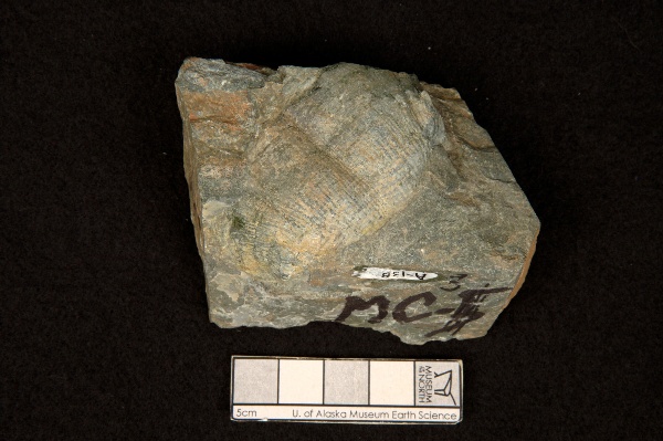
"dwc:identificationRemarks": "?Kochiproductus sp.; Former nature_of_id: field.",
"dwc:verbatimCoordinates": "63.262433/-145.595594",
"dwc:kingdom": "Animalia",
"dwc:recordedBy": "Collector(s): Charles Rowett",
"dwc:georeferencedDate": "2013-10-09 00:00:00",
"dcterms:references": "http://arctos.database.museum/guid/UAM:ES:33006",
"dcterms:accessRights": "http://vertnet.org/resources/norms.html",
"dwc:occurrenceID": "http://arctos.database.museum/guid/UAM:ES:33006?seid=2009793",
"id": "http://arctos.database.museum/guid/UAM:ES:33006?seid=2009793",
"dwc:establishmentMeans": "wild",
"dwc:minimumElevationInMeters": "1615",
"dwc:stateProvince": "Alaska",
"dwc:eventDate": "1963-01-01/1966-12-31",
"dwc:collectionID": "21",
"dwc:institutionCode": "UAM",
"dwc:country": "United States",
"dwc:earliestPeriodOrLowestSystem": "Permian",
"dwc:collectionCode": "ES",
"dwc:decimalLatitude": "63.2621390000",
"dwc:georeferenceVerificationStatus": "unverified",
"dwc:maximumElevationInMeters": "1615",
"dwc:basisOfRecord": "PreservedSpecimen",
"dwc:preparations": "exoskeleton",
"dwc:identifiedBy": "Charles Rowett",
"dwc:identificationVerificationStatus": "features",
"dwc:georeferenceSources": "GeoLocate",
"dwc:previousIdentifications": "[{\"scientific_name\":\"Brachiopoda\",\"nature_of_id\":\"features\",\"accepted_id_fg\":1,\"made_date\":null,\"short_citation\":null,\"publication_id\":null,\"identification_remarks\":\"?Kochiproductus sp.; Former nature_of_id: field.\",\"idby\":\"Charles Rowett\",\"concept_label\":null}]",
"dwc:organismID": "http://arctos.database.museum/guid/UAM:ES:33006",
"dwc:phylum": "Brachiopoda",
"dwc:locationAccordingTo": "Bobby Ebelhar",
"dwc:locality": "South side of Rainbow Mountain, southern Rainbow Mountain area, Mt. Hayes Quad",
"dwc:institutionID": "UAM",
"dwc:associatedMedia": "http://arctos.database.museum/MediaSearch.cfm?collection_object_id=22856065",
"dwc:geodeticDatum": "World Geodetic System 1984",
"dwc:taxonRank": "phylum",
"dwc:higherClassification": "Animalia,",
"dwc:catalogNumber": "UAM:ES:33006",
"dwc:nomenclaturalCode": "ICZN",
"dwc:higherGeography": "United States, Alaska",
"dwc:decimalLongitude": "-145.5882770000",
"dwc:coordinateUncertaintyInMeters": "579",
"dwc:otherCatalogNumbers": "collector number=MC-3, other identifier=A-138",
"dwc:verbatimLocality": ".6 miles NE small creek that crosses Richardson Hwy. at mile 208.7, approx. 2.3 miles up creek from Hwy. Elevation 5300 ft, south side of Rainbow Mtn., southern Rainbow Mtn. area",
"dwc:georeferencedBy": "Bobby Ebelhar",
"dwc:verbatimEventDate": "1963-1966",
"dwc:eventTime": "1963-01-01/1966-12-31",
"dwc:recordNumber": "MC-3",
"dwc:identificationQualifier": "A",
"dwc:verbatimCoordinateSystem": "decimal degrees",
"dwc:georeferenceProtocol": "GeoLocate",
"dcterms:modified": "2022-10-26 08:49:39.847282",
"dwc:scientificName": "Brachiopoda",
"dwc:footprintWKT": "POLYGON((-145.576746189101 63.2620241976892,-145.577017654555 63.2610129388506,-145.577721759797 63.2600449687607,-145.578831409508 63.2591574797591,-145.580303936844 63.2583845686562,-145.582082746693 63.257755927766,-145.584099491612 63.2572957054032,-145.586276696668 63.2570215793993,-145.588530732581 63.2569440790093,-145.590775023541 63.2570661810778,-145.592923367341 63.257383195861,-145.594893241291 63.2578829468602,-145.596608967889 63.2585462378143,-145.59800461947 63.2593475890487,-145.599026550738 63.2602562150894,-145.599635462023 63.2612372062081,-145.599807913718 63.2622528687264,-145.599537233056 63.2632641727608,-145.598833777476 63.2642322518967,-145.597724543391 63.265119897193,-145.596252134369 63.2658929880451,-145.594473127511 63.2665218047737,-145.592455900253 63.2669821722943,-145.590278000959 63.2672563906765,-145.588023164601 63.2673339166014,-145.585778088848 63.267211769337,-145.583629095386 63.2668946455079,-145.581658805811 63.2663947382139,-145.579942960898 63.2657312675107,-145.578547506326 63.2649297404379,-145.577526057397 63.2640209692394,-145.57691784035 63.2630398857424,-145.576746189101 63.2620241976892))"
},
"indexTerms": {
"geopoint": {
"lat": 63.262139,
"lon": -145.588277
},
"family": "sphaeroceridae",
"recordset": "2ec3b31e-c86b-4ce9-b265-77c8c3f9643c",
"dqs": 0.2898550724637681,
"stateprovince": "alaska",
"earliestperiodorlowestsystem": "permian",
"phylum": "arthropoda",
"catalognumber": "uam:es:33006",
"taxonrank": "genus",
"collector": "collector(s): charles rowett",
"verbatimlocality": ".6 miles ne small creek that crosses richardson hwy. at mile 208.7, approx. 2.3 miles up creek from hwy. elevation 5300 ft, south side of rainbow mtn., southern rainbow mtn. area",
"datemodified": "2022-12-07T00:43:16.130603+00:00",
"uuid": "3d9d715c-6e72-48b7-9e3c-6effb170f662",
"countrycode": "usa",
"basisofrecord": "preservedspecimen",
"institutioncode": "uam",
"mediarecords": [
"eb386fd3-5865-43e7-92f9-2f0b2ffad581"
],
"continent": "north america",
"etag": "2a99bb5cd98a7739b4433ae1cb33bb7ada84c18b",
"recordnumber": "mc-3",
"minelevation": 1615,
"hasImage": true,
"kingdom": "animalia",
"maxelevation": 1615,
"highertaxon": "animalia,",
"collectionid": "21",
"taxonid": "1587954",
"scientificname": "brachiopoda",
"indexData": {
"dwc:verbatimCoordinates": "63.262433/-145.595594",
"idigbio:dateModified": "2022-12-07T00:43:16.130603",
"idigbio:uuid": "3d9d715c-6e72-48b7-9e3c-6effb170f662",
"dwc:georeferencedDate": "2013-10-09 00:00:00",
"gbif:canonicalname": "rachispoda",
"dwc:occurrenceID": "http://arctos.database.museum/guid/UAM:ES:33006?seid=2009793",
"flag_dwc_taxonrank_replaced": true,
"flag_gbif_genericname_added": true,
"flag_dwc_parentnameusageid_added": true,
"flag_dwc_datasetid_added": true,
"idigbio:parent": "2ec3b31e-c86b-4ce9-b265-77c8c3f9643c",
"dwc:country": "United States",
"dwc:earliestPeriodOrLowestSystem": "Permian",
"idigbio:etag": "2a99bb5cd98a7739b4433ae1cb33bb7ada84c18b",
"dwc:decimalLatitude": "63.2621390000",
"dwc:maximumElevationInMeters": "1615",
"dwc:taxonid": "1587954",
"dwc:datasetid": "7ddf754f-d193-4cc9-b351-99906754a03b",
"flag_dwc_continent_added": true,
"dwc:identificationVerificationStatus": "features",
"dwc:georeferenceSources": "GeoLocate",
"dwc:preparations": "exoskeleton",
"flag_idigbio_isocountrycode_added": true,
"dwc:scientificnameauthorship": "lioy, 1864",
"dwc:locality": "South side of Rainbow Mountain, southern Rainbow Mountain area, Mt. Hayes Quad",
"dwc:geodeticDatum": "World Geodetic System 1984",
"dwc:taxonRank": "genus",
"dwc:higherClassification": "Animalia,",
"dwc:catalogNumber": "UAM:ES:33006",
"dwc:nomenclaturalCode": "ICZN",
"dwc:higherGeography": "United States, Alaska",
"flag_dwc_scientificnameauthorship_added": true,
"dwc:decimalLongitude": "-145.5882770000",
"flag_dwc_order_added": true,
"dwc:georeferencedBy": "Bobby Ebelhar",
"dwc:eventTime": "1963-01-01/1966-12-31",
"dwc:family": "sphaeroceridae",
"dwc:verbatimCoordinateSystem": "decimal degrees",
"flag_dwc_genus_added": true,
"dwc:coordinateUncertaintyInMeters": "579",
"dwc:identificationRemarks": "?Kochiproductus sp.; Former nature_of_id: field.",
"dwc:kingdom": "Animalia",
"dwc:recordedBy": "Collector(s): Charles Rowett",
"dwc:order": "diptera",
"dcterms:references": "http://arctos.database.museum/guid/UAM:ES:33006",
"dcterms:accessRights": "http://vertnet.org/resources/norms.html",
"idigbio:recordIds": [
"2ec3b31e-c86b-4ce9-b265-77c8c3f9643c\\urn:occurrence:arctos:uam:es:33006:2009793",
"2ec3b31e-c86b-4ce9-b265-77c8c3f9643c\\http://arctos.database.museum/guid/uam:es:33006?seid=2009793"
],
"flag_dwc_taxonomicstatus_added": true,
"id": "http://arctos.database.museum/guid/UAM:ES:33006?seid=2009793",
"dwc:establishmentMeans": "wild",
"dwc:stateProvince": "Alaska",
"dwc:eventDate": "1963-01-01/1966-12-31",
"dwc:collectionID": "21",
"dwc:minimumElevationInMeters": "1615",
"dwc:collectionCode": "ES",
"dwc:georeferenceVerificationStatus": "unverified",
"dwc:basisOfRecord": "PreservedSpecimen",
"dwc:taxonomicstatus": "accepted",
"dwc:genus": "rachispoda",
"dwc:continent": "north america",
"dwc:identificationQualifier": "A",
"dwc:identifiedBy": "Charles Rowett",
"flag_dwc_taxonid_added": true,
"dwc:previousIdentifications": "[{\"scientific_name\":\"Brachiopoda\",\"nature_of_id\":\"features\",\"accepted_id_fg\":1,\"made_date\":null,\"short_citation\":null,\"publication_id\":null,\"identification_remarks\":\"?Kochiproductus sp.; Former nature_of_id: field.\",\"idby\":\"Charles Rowett\",\"concept_label\":null}]",
"idigbio:siblings": {
"mediarecord": [
"eb386fd3-5865-43e7-92f9-2f0b2ffad581"
]
},
"dwc:organismID": "http://arctos.database.museum/guid/UAM:ES:33006",
"dwc:phylum": "arthropoda",
"gbif:genericname": "rachispoda",
"dwc:locationAccordingTo": "Bobby Ebelhar",
"dwc:institutionID": "UAM",
"dwc:associatedMedia": "http://arctos.database.museum/MediaSearch.cfm?collection_object_id=22856065",
"dwc:institutionCode": "UAM",
"flag_gbif_taxon_corrected": true,
"dwc:parentnameusageid": "6924",
"dwc:class": "insecta",
"flag_dwc_phylum_replaced": true,
"flag_gbif_canonicalname_added": true,
"dwc:otherCatalogNumbers": "collector number=MC-3, other identifier=A-138",
"dwc:verbatimLocality": ".6 miles NE small creek that crosses Richardson Hwy. at mile 208.7, approx. 2.3 miles up creek from Hwy. Elevation 5300 ft, south side of Rainbow Mtn., southern Rainbow Mtn. area",
"dwc:verbatimEventDate": "1963-1966",
"dwc:recordNumber": "MC-3",
"idigbio:isocountrycode": "usa",
"flag_dwc_family_added": true,
"flag_dwc_class_added": true,
"dwc:georeferenceProtocol": "GeoLocate",
"dcterms:modified": "2022-10-26 08:49:39.847282",
"dwc:scientificName": "Brachiopoda",
"dwc:footprintWKT": "POLYGON((-145.576746189101 63.2620241976892,-145.577017654555 63.2610129388506,-145.577721759797 63.2600449687607,-145.578831409508 63.2591574797591,-145.580303936844 63.2583845686562,-145.582082746693 63.257755927766,-145.584099491612 63.2572957054032,-145.586276696668 63.2570215793993,-145.588530732581 63.2569440790093,-145.590775023541 63.2570661810778,-145.592923367341 63.257383195861,-145.594893241291 63.2578829468602,-145.596608967889 63.2585462378143,-145.59800461947 63.2593475890487,-145.599026550738 63.2602562150894,-145.599635462023 63.2612372062081,-145.599807913718 63.2622528687264,-145.599537233056 63.2632641727608,-145.598833777476 63.2642322518967,-145.597724543391 63.265119897193,-145.596252134369 63.2658929880451,-145.594473127511 63.2665218047737,-145.592455900253 63.2669821722943,-145.590278000959 63.2672563906765,-145.588023164601 63.2673339166014,-145.585778088848 63.267211769337,-145.583629095386 63.2668946455079,-145.581658805811 63.2663947382139,-145.579942960898 63.2657312675107,-145.578547506326 63.2649297404379,-145.577526057397 63.2640209692394,-145.57691784035 63.2630398857424,-145.576746189101 63.2620241976892))"
},
"hasMedia": true,
"coordinateuncertainty": 579,
"class": "insecta",
"occurrenceid": "http://arctos.database.museum/guid/uam:es:33006?seid=2009793",
"institutionid": "uam",
"country": "united states",
"locality": "south side of rainbow mountain, southern rainbow mountain area, mt. hayes quad",
"collectioncode": "es",
"canonicalname": "rachispoda",
"eventdate": "1963-01-01/1966-12-31",
"flags": [
"geopoint_datum_error",
"dwc_taxonrank_replaced",
"gbif_genericname_added",
"dwc_parentnameusageid_added",
"dwc_datasetid_added",
"dwc_continent_added",
"idigbio_isocountrycode_added",
"dwc_scientificnameauthorship_added",
"dwc_order_added",
"dwc_genus_added",
"dwc_taxonomicstatus_added",
"dwc_taxonid_added",
"gbif_taxon_corrected",
"dwc_phylum_replaced",
"gbif_canonicalname_added",
"dwc_family_added",
"dwc_class_added"
],
"verbatimeventdate": "1963-1966",
"taxonomicstatus": "accepted",
"recordids": [
"2ec3b31e-c86b-4ce9-b265-77c8c3f9643c\\urn:occurrence:arctos:uam:es:33006:2009793",
"2ec3b31e-c86b-4ce9-b265-77c8c3f9643c\\http://arctos.database.museum/guid/uam:es:33006?seid=2009793"
],
"genus": "rachispoda",
"order": "diptera",
"datasetid": "7ddf754f-d193-4cc9-b351-99906754a03b"
},
"attribution": {
"totalCount": 51496
}
}