{
"uuid": "37b9eacc-2d06-42ce-bc8c-c197b6571dda",
"type": "records",
"etag": "f85165b276dbe6c4256ee649c3505add470a21fe",
"data": {
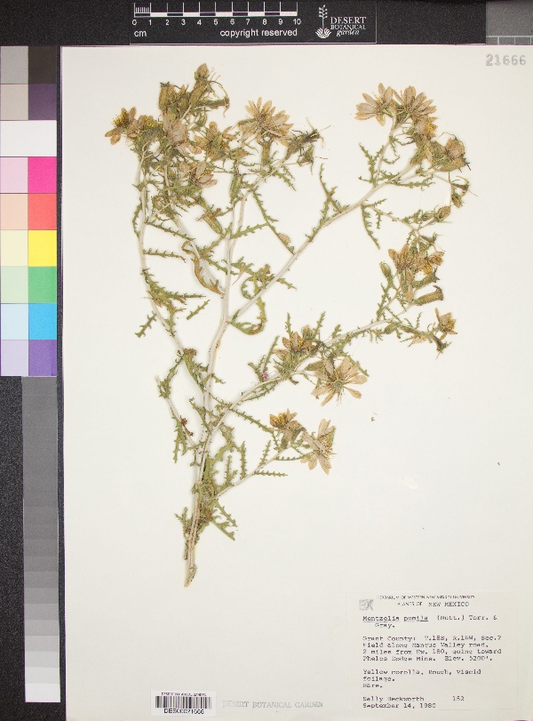
"dwc:startDayOfYear": "258",
"dwc:county": "Grant County",
"dwc:recordedBy": "Sally Beckworth",
"dwc:georeferenceSources": "ACC_082911",
"dcterms:references": "https://swbiodiversity.org/seinet/collections/individual/index.php?occid=3094584",
"dwc:occurrenceID": "ab6b94f1-45b1-4e9f-ba7c-85d64487096a",
"dwc:verbatimElevation": "- 5200ft.",
"id": "3094584",
"dwc:stateProvince": "New Mexico",
"dwc:eventDate": "1980-09-14",
"dwc:collectionID": "edb9860c-c481-4d19-88cc-224a536ebcd4",
"dwc:country": "USA",
"symbiota:recordEnteredBy": "kbarron",
"dwc:decimalLatitude": "32.760608",
"dwc:occurrenceRemarks": "Yellow corolla, rough, viscid foliage. Rare.",
"dwc:basisOfRecord": "PreservedSpecimen",
"dc:rights": "http://creativecommons.org/licenses/by-nc/3.0/",
"symbiota:recordID": "ab6b94f1-45b1-4e9f-ba7c-85d64487096a",
"dwc:locality": "Field along Mangus Valley Road, 2 miles from Hwy 180, goint toward Phelps Dodge Mine.",
"dwc:institutionCode": "DES",
"dwc:reproductiveCondition": "Flowering",
"dwc:catalogNumber": "DES00021666",
"dwc:month": "9",
"dwc:decimalLongitude": "-108.460431",
"dwc:recordNumber": "152",
"dwc:minimumElevationInMeters": "1584",
"dcterms:modified": "2017-12-09 15:07:33",
"dwc:day": "14",
"dwc:year": "1980"
},
"indexTerms": {
"recordset": "c569e530-7322-40b8-9b66-1e0ed96fefcb",
"dqs": 0.2318840579710145,
"stateprovince": "new mexico",
"county": "grant county",
"catalognumber": "des00021666",
"startdayofyear": 258,
"collector": "sally beckworth",
"continent": "north america",
"uuid": "37b9eacc-2d06-42ce-bc8c-c197b6571dda",
"countrycode": "usa",
"basisofrecord": "preservedspecimen",
"institutioncode": "des",
"mediarecords": [
"aae02ec4-5132-4240-8ed7-1504f65ebae9"
],
"datecollected": "1980-09-14T00:00:00+00:00",
"etag": "f85165b276dbe6c4256ee649c3505add470a21fe",
"recordnumber": "152",
"minelevation": 1584,
"hasImage": true,
"collectionid": "edb9860c-c481-4d19-88cc-224a536ebcd4",
"locality": "field along mangus valley road, 2 miles from hwy 180, goint toward phelps dodge mine.",
"hasMedia": true,
"datemodified": "2022-12-06T22:03:37.426550+00:00",
"occurrenceid": "ab6b94f1-45b1-4e9f-ba7c-85d64487096a",
"country": "united states",
"geopoint": {
"lat": 32.760608,
"lon": -108.460431
},
"flags": [
"geopoint_datum_missing",
"dwc_country_replaced",
"idigbio_isocountrycode_added",
"dwc_continent_added"
],
"recordids": [
"urn:uuid:ab6b94f1-45b1-4e9f-ba7c-85d64487096a",
"c569e530-7322-40b8-9b66-1e0ed96fefcb\\3094584",
"c569e530-7322-40b8-9b66-1e0ed96fefcb\\urn:uuid:ab6b94f1-45b1-4e9f-ba7c-85d64487096a",
"c569e530-7322-40b8-9b66-1e0ed96fefcb\\ab6b94f1-45b1-4e9f-ba7c-85d64487096a"
],
"eventdate": "1980-09-14",
"indexData": {
"dwc:startDayOfYear": "258",
"dwc:county": "Grant County",
"dwc:recordedBy": "Sally Beckworth",
"idigbio:uuid": "37b9eacc-2d06-42ce-bc8c-c197b6571dda",
"dwc:locality": "Field along Mangus Valley Road, 2 miles from Hwy 180, goint toward Phelps Dodge Mine.",
"dcterms:references": "https://swbiodiversity.org/seinet/collections/individual/index.php?occid=3094584",
"idigbio:recordIds": [
"urn:uuid:ab6b94f1-45b1-4e9f-ba7c-85d64487096a",
"c569e530-7322-40b8-9b66-1e0ed96fefcb\\3094584",
"c569e530-7322-40b8-9b66-1e0ed96fefcb\\urn:uuid:ab6b94f1-45b1-4e9f-ba7c-85d64487096a",
"c569e530-7322-40b8-9b66-1e0ed96fefcb\\ab6b94f1-45b1-4e9f-ba7c-85d64487096a"
],
"dwc:occurrenceID": "ab6b94f1-45b1-4e9f-ba7c-85d64487096a",
"dwc:verbatimElevation": "- 5200ft.",
"symbiota:recordEnteredBy": "kbarron",
"idigbio:parent": "c569e530-7322-40b8-9b66-1e0ed96fefcb",
"dwc:stateProvince": "New Mexico",
"dwc:eventDate": "1980-09-14",
"dwc:collectionID": "edb9860c-c481-4d19-88cc-224a536ebcd4",
"dwc:country": "united states",
"idigbio:etag": "f85165b276dbe6c4256ee649c3505add470a21fe",
"id": "3094584",
"dwc:decimalLatitude": "32.760608",
"dwc:occurrenceRemarks": "Yellow corolla, rough, viscid foliage. Rare.",
"dwc:basisOfRecord": "PreservedSpecimen",
"dwc:continent": "north america",
"dc:rights": "http://creativecommons.org/licenses/by-nc/3.0/",
"flag_dwc_country_replaced": true,
"idigbio:siblings": {
"mediarecord": [
"aae02ec4-5132-4240-8ed7-1504f65ebae9"
]
},
"symbiota:recordID": "ab6b94f1-45b1-4e9f-ba7c-85d64487096a",
"flag_idigbio_isocountrycode_added": true,
"idigbio:dateModified": "2022-12-06T22:03:37.426550",
"dwc:georeferenceSources": "ACC_082911",
"dwc:institutionCode": "DES",
"dwc:reproductiveCondition": "Flowering",
"dwc:catalogNumber": "DES00021666",
"dwc:month": "9",
"dwc:decimalLongitude": "-108.460431",
"flag_dwc_continent_added": true,
"dwc:recordNumber": "152",
"idigbio:isocountrycode": "usa",
"dwc:minimumElevationInMeters": "1584",
"dcterms:modified": "2017-12-09 15:07:33",
"dwc:day": "14",
"dwc:year": "1980"
}
},
"attribution": {
"totalCount": 94693
}
}