{
"uuid": "373f2463-e53c-47a7-8faf-bda461c34c09",
"type": "records",
"etag": "3abf5d276689b8de0b495ce37c98d18ce38c3e70",
"data": {
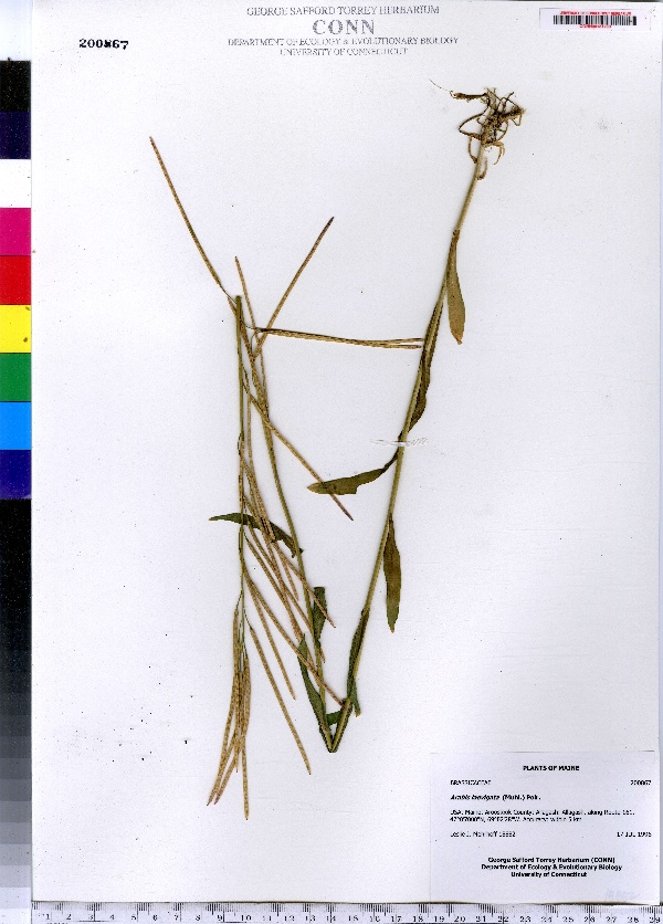
"dwc:specificEpithet": "laevigata",
"dwc:countryCode": "US",
"dwc:county": "Aroostook County",
"dwc:recordedBy": "Leslie J. Mehrhoff",
"dwc:georeferenceSources": "2006. Google Earth. © Google Earth.",
"dwc:order": "Capparales",
"dwc:occurrenceID": "urn:catalog:UConn:CONN:CONN00131790",
"dwc:stateProvince": "Maine",
"dwc:eventDate": "1996-07-17",
"dwc:country": "USA",
"dwc:collectionCode": "CONN",
"dwc:verbatimLatitude": "47°05' 000 N",
"dwc:kingdom": "Dicotyledonae",
"dwc:decimalLatitude": "47.08333",
"dwc:basisOfRecord": "Preserved Specimen",
"dwc:genus": "Arabis",
"dwc:family": "Brassicaceae",
"dwc:coordinateUncertaintyInMeters": "5000",
"dwc:municipality": "Allagash",
"dwc:previousIdentifications": "Arabis laevigata (Muhl.) Poir.",
"dwc:vernacularName": "smooth rockcress",
"dwc:locationAccordingTo": "seconds added from gazetteer",
"dwc:locality": "Allagash, along Route 161",
"dwc:institutionCode": "UConn",
"dwc:reproductiveCondition": "fruiting",
"dwc:higherClassification": "Plantae; Dicotyledonae; Capparales; Brassicaceae",
"dwc:catalogNumber": "CONN00131790",
"dwc:higherGeography": "USA; Maine; Aroostook County; Allagash",
"dwc:month": "7",
"dwc:decimalLongitude": "-69.04111",
"dwc:verbatimLongitude": "69°02' 28\" W",
"dwc:verbatimEventDate": "17-Jul-96",
"dwc:recordNumber": "18882",
"dcterms:rights": "This work is licensed under a Creative Commons CCZero 1.0 License http://i.creativecommons.org/l/by-nc-sa/4.0/88x31.png",
"dcterms:modified": "2011-09-14T00:00-0500",
"dwc:scientificName": "Arabis laevigata (Muhl.) Poir.",
"dwc:day": "17",
"dwc:datasetID": "119188",
"dwc:year": "1996"
},
"indexTerms": {
"family": "brassicaceae",
"recordset": "e70af26a-fb9e-43ab-96a0-d62a2df37e6d",
"dqs": 0.37681159420289856,
"stateprovince": "maine",
"institutioncode": "uconn",
"municipality": "allagash",
"county": "aroostook county",
"catalognumber": "conn00131790",
"startdayofyear": 199,
"specificepithet": "laevigata",
"continent": "north america",
"uuid": "373f2463-e53c-47a7-8faf-bda461c34c09",
"countrycode": "usa",
"basisofrecord": "preservedspecimen",
"collector": "leslie j. mehrhoff",
"commonnames": [
"smooth rockcress"
],
"mediarecords": [
"13a3dc32-41bf-4cb2-8c9c-4b4672320e5e"
],
"datecollected": "1996-07-17T00:00:00+00:00",
"etag": "3abf5d276689b8de0b495ce37c98d18ce38c3e70",
"recordnumber": "18882",
"hasImage": true,
"kingdom": "dicotyledonae",
"highertaxon": "plantae; dicotyledonae; capparales; brassicaceae",
"commonname": "smooth rockcress",
"scientificname": "arabis laevigata (muhl.) poir.",
"locality": "allagash, along route 161",
"hasMedia": true,
"coordinateuncertainty": 5000,
"datemodified": "2014-09-12T19:39:21.615000+00:00",
"occurrenceid": "urn:catalog:uconn:conn:conn00131790",
"country": "united states",
"geopoint": {
"lat": 47.08333,
"lon": -69.04111
},
"collectioncode": "conn",
"eventdate": "1996-07-17",
"flags": [
"geopoint_datum_missing",
"dwc_continent_added",
"dwc_country_replaced",
"idigbio_isocountrycode_added",
"taxon_match_failed"
],
"verbatimeventdate": "17-jul-96",
"recordids": [
"e70af26a-fb9e-43ab-96a0-d62a2df37e6d\\urn:catalog:uconn:conn:conn00131790"
],
"genus": "arabis",
"order": "capparales",
"datasetid": "119188",
"indexData": {
"dwc:specificEpithet": "laevigata",
"dwc:countryCode": "US",
"dwc:county": "Aroostook County",
"dwc:recordedBy": "Leslie J. Mehrhoff",
"idigbio:uuid": "373f2463-e53c-47a7-8faf-bda461c34c09",
"dwc:georeferenceSources": "2006. Google Earth. © Google Earth.",
"dwc:order": "Capparales",
"idigbio:isocountrycode": "usa",
"dwc:locality": "Allagash, along Route 161",
"idigbio:recordIds": [
"e70af26a-fb9e-43ab-96a0-d62a2df37e6d\\urn:catalog:uconn:conn:conn00131790"
],
"dwc:occurrenceID": "urn:catalog:UConn:CONN:CONN00131790",
"dwc:scientificName": "Arabis laevigata (Muhl.) Poir.",
"idigbio:parent": "e70af26a-fb9e-43ab-96a0-d62a2df37e6d",
"dwc:stateProvince": "Maine",
"dwc:eventDate": "1996-07-17",
"dwc:country": "united states",
"idigbio:etag": "3abf5d276689b8de0b495ce37c98d18ce38c3e70",
"dwc:collectionCode": "CONN",
"dwc:verbatimLatitude": "47°05' 000 N",
"dwc:kingdom": "Dicotyledonae",
"dwc:decimalLatitude": "47.08333",
"dwc:basisOfRecord": "Preserved Specimen",
"dwc:genus": "Arabis",
"dwc:continent": "north america",
"dwc:family": "Brassicaceae",
"flag_dwc_continent_added": true,
"flag_dwc_country_replaced": true,
"dwc:municipality": "Allagash",
"dwc:previousIdentifications": "Arabis laevigata (Muhl.) Poir.",
"idigbio:siblings": {
"mediarecord": [
"13a3dc32-41bf-4cb2-8c9c-4b4672320e5e"
]
},
"flag_idigbio_isocountrycode_added": true,
"dwc:vernacularName": "smooth rockcress",
"idigbio:dateModified": "2014-09-12T19:39:21.615000",
"dwc:locationAccordingTo": "seconds added from gazetteer",
"dwc:institutionCode": "UConn",
"dwc:reproductiveCondition": "fruiting",
"dwc:higherClassification": "Plantae; Dicotyledonae; Capparales; Brassicaceae",
"dwc:catalogNumber": "CONN00131790",
"dwc:higherGeography": "USA; Maine; Aroostook County; Allagash",
"dwc:month": "7",
"dwc:decimalLongitude": "-69.04111",
"dwc:verbatimLongitude": "69°02' 28\" W",
"dwc:verbatimEventDate": "17-Jul-96",
"dwc:recordNumber": "18882",
"dcterms:rights": "This work is licensed under a Creative Commons CCZero 1.0 License http://i.creativecommons.org/l/by-nc-sa/4.0/88x31.png",
"flag_taxon_match_failed": true,
"dcterms:modified": "2011-09-14T00:00-0500",
"dwc:coordinateUncertaintyInMeters": "5000",
"dwc:day": "17",
"dwc:datasetID": "119188",
"dwc:year": "1996"
}
},
"attribution": {
"totalCount": 172098
}
}