{
"uuid": "2fcabc6a-b126-4d0c-9e1f-d03d9baccefd",
"type": "records",
"etag": "7a28ba8d0f5874c01c0068eb5bd3b793bde09573",
"data": {
"dwc:startDayOfYear": "249",
"dwc:verbatimTaxonRank": "var.",
"dwc:specificEpithet": "trichophyllus",
"dwc:county": "Coconino",
"dwc:recordedBy": "J. Ricketson",
"dwc:georeferenceSources": "LL from TRS- 050106",
"dwc:order": "Ranunculales",
"dcterms:references": "https://swbiodiversity.org/seinet/collections/individual/index.php?occid=2093728",
"dwc:scientificNameAuthorship": "Chaix",
"dwc:occurrenceID": "35cbc3b7-7a61-42db-a29c-a21bfd9a6933",
"dwc:verbatimCoordinates": "T13N R09E S09",
"dwc:verbatimElevation": "6890ft.",
"id": "2093728",
"dwc:taxonID": "10988",
"dwc:stateProvince": "Arizona",
"dwc:eventDate": "1985-09-06",
"symbiota:recordEnteredBy": "Keri",
"dwc:collectionID": "17a53c97-835b-409e-8a9a-c9a7307a4965",
"dwc:country": "United States",
"dcterms:rightsHolder": "Deaver Herbarium",
"dwc:kingdom": "Plantae",
"dwc:decimalLatitude": "34.5293",
"dwc:associatedOccurrences": "herbariumSpecimenDuplicate: https://swbiodiversity.org/seinet/collections/individual/index.php?guid=urn:catalog:MO:Tropicos:100866812|herbariumSpecimenDuplicate: https://swbiodiversity.org/seinet/collections/individual/index.php?guid=1b15a685-b51f-435d-8212-aa325d95737e",
"dwc:basisOfRecord": "PreservedSpecimen",
"dwc:genus": "Ranunculus",
"dwc:family": "Ranunculaceae",
"dc:rights": "http://creativecommons.org/licenses/by/3.0/",
"dwc:coordinateUncertaintyInMeters": "1250",
"symbiota:recordID": "35cbc3b7-7a61-42db-a29c-a21bfd9a6933",
"dwc:infraspecificEpithet": "trichophyllus",
"dwc:phylum": "Magnoliophyta",
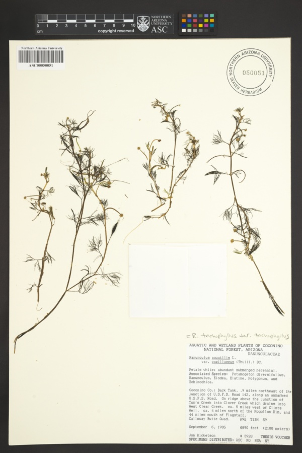
"dwc:locality": "Coconino National Forest, Calloway Butte Quad., Back Tank, 0.9 miles northeast of junction U.S.F.S. Rd 142 along unmarked U.S.F.S. Rd. On ridge above junction of Tom's Creek into Clover Creek which drains into West Clear Creek. Ca. 5 miles west of Clints Well. Ca. 4 miles north of Mogollon Rim. 44 miles south of Flagstaff",
"dwc:institutionCode": "ASC",
"dwc:taxonRank": "Variety",
"dwc:higherClassification": "Plantae|Magnoliophyta|Eudicots|Ranunculales|Ranunculaceae|Ranunculus|Ranunculus trichophyllus",
"dwc:catalogNumber": "ASC00050051",
"dwc:month": "9",
"dwc:decimalLongitude": "-111.401",
"dwc:scientificName": "Ranunculus trichophyllus var. trichophyllus",
"dwc:recordNumber": "3928",
"dwc:minimumElevationInMeters": "2100",
"dcterms:modified": "2020-10-31 19:29:57",
"dwc:associatedTaxa": "ecologicallyOccursWith: Potamogeton diversifolius|ecologicallyOccursWith: Ranunculus|ecologicallyOccursWith: Elodea|ecologicallyOccursWith: Elatine|ecologicallyOccursWith: Polygonum|ecologicallyOccursWith: Echinochloa",
"dwc:day": "6",
"dwc:year": "1985"
},
"indexTerms": {
"geopoint": {
"lat": 34.5293,
"lon": -111.401
},
"family": "ranunculaceae",
"recordset": "b531ea59-025d-4c29-9d23-99ae75bcd55f",
"dqs": 0.2753623188405797,
"stateprovince": "arizona",
"county": "coconino",
"phylum": "tracheophyta",
"catalognumber": "asc00050051",
"startdayofyear": 249,
"taxonrank": "species",
"specificepithet": "trichophyllus",
"continent": "north america",
"uuid": "2fcabc6a-b126-4d0c-9e1f-d03d9baccefd",
"countrycode": "usa",
"basisofrecord": "preservedspecimen",
"collector": "j. ricketson",
"institutioncode": "asc",
"mediarecords": [
"3b248aee-a960-4fd3-a2f9-6f61fcbe8dcd"
],
"datemodified": "2023-01-11T02:45:27.678261+00:00",
"datecollected": "1985-09-06T00:00:00+00:00",
"etag": "7a28ba8d0f5874c01c0068eb5bd3b793bde09573",
"recordnumber": "3928",
"minelevation": 2100,
"hasImage": true,
"kingdom": "plantae",
"highertaxon": "plantae|magnoliophyta|eudicots|ranunculales|ranunculaceae|ranunculus|ranunculus trichophyllus",
"collectionid": "17a53c97-835b-409e-8a9a-c9a7307a4965",
"taxonid": "3033377",
"scientificname": "ranunculus trichophyllus var. trichophyllus",
"indexData": {
"dwc:startDayOfYear": "249",
"dwc:verbatimTaxonRank": "var.",
"dwc:specificEpithet": "trichophyllus",
"idigbio:dateModified": "2023-01-11T02:45:27.678261",
"dwc:county": "Coconino",
"dwc:recordedBy": "J. Ricketson",
"idigbio:uuid": "2fcabc6a-b126-4d0c-9e1f-d03d9baccefd",
"dwc:locality": "Coconino National Forest, Calloway Butte Quad., Back Tank, 0.9 miles northeast of junction U.S.F.S. Rd 142 along unmarked U.S.F.S. Rd. On ridge above junction of Tom's Creek into Clover Creek which drains into West Clear Creek. Ca. 5 miles west of Clints Well. Ca. 4 miles north of Mogollon Rim. 44 miles south of Flagstaff",
"dwc:order": "Ranunculales",
"dcterms:references": "https://swbiodiversity.org/seinet/collections/individual/index.php?occid=2093728",
"flag_gbif_reference_added": true,
"dwc:scientificNameAuthorship": "chaix",
"flag_dwc_taxonid_replaced": true,
"dwc:occurrenceID": "35cbc3b7-7a61-42db-a29c-a21bfd9a6933",
"flag_dwc_taxonrank_replaced": true,
"id": "2093728",
"dwc:verbatimCoordinates": "T13N R09E S09",
"dwc:verbatimElevation": "6890ft.",
"flag_dwc_taxonomicstatus_added": true,
"flag_gbif_genericname_added": true,
"symbiota:recordEnteredBy": "Keri",
"dwc:taxonID": "3033377",
"idigbio:parent": "b531ea59-025d-4c29-9d23-99ae75bcd55f",
"dwc:stateProvince": "Arizona",
"flag_gbif_taxon_corrected": true,
"dwc:eventDate": "1985-09-06",
"flag_dwc_scientificnameauthorship_replaced": true,
"dwc:collectionID": "17a53c97-835b-409e-8a9a-c9a7307a4965",
"dwc:country": "United States",
"dwc:multimedia": [
{
"dcterms:license": "creative commons attribution share alike 3.0 unported",
"dcterms:references": "http://commons.wikimedia.org/wiki/file:ranunculustrichophyllus.jpg",
"coreid": "3033377",
"dcterms:identifier": "http://upload.wikimedia.org/wikipedia/commons/f/f7/ranunculustrichophyllus.jpg",
"dcterms:source": "german wikipedia - species pages",
"dcterms:description": "english: flowering plants of ranunculus trichophyllus (ranunculaceae). deutsch: blühender haarblättriger wasserhahnenfuß (ranunculus trichophyllus ssp. trichophyllus) – eine art aus dem bestimmungskritischen sammeltaxon ranunculus aquatilis agg. schwimmblätter sind bei dieser art meistens nicht vorhanden, sondern nur die haarfein zerteilten tauchblätter. die blüten haben einen etwas kleineren durchmesser als bei einigen anderen wasserhahnenfußarten.",
"dcterms:creator": "christian fischer",
"dcterms:publisher": "wikimedia commons"
}
],
"idigbio:etag": "7a28ba8d0f5874c01c0068eb5bd3b793bde09573",
"flag_dwc_multimedia_added": true,
"dcterms:rightsHolder": "Deaver Herbarium",
"dwc:kingdom": "Plantae",
"dwc:decimalLatitude": "34.5293",
"dwc:associatedOccurrences": "herbariumSpecimenDuplicate: https://swbiodiversity.org/seinet/collections/individual/index.php?guid=urn:catalog:MO:Tropicos:100866812|herbariumSpecimenDuplicate: https://swbiodiversity.org/seinet/collections/individual/index.php?guid=1b15a685-b51f-435d-8212-aa325d95737e",
"dwc:basisOfRecord": "PreservedSpecimen",
"dwc:taxonomicstatus": "accepted",
"dwc:genus": "Ranunculus",
"dwc:continent": "north america",
"dwc:family": "Ranunculaceae",
"dc:rights": "http://creativecommons.org/licenses/by/3.0/",
"flag_dwc_parentnameusageid_added": true,
"flag_dwc_datasetid_added": true,
"dwc:class": "magnoliopsida",
"gbif:canonicalname": "ranunculus trichophyllus",
"dwc:associatedTaxa": "ecologicallyOccursWith: Potamogeton diversifolius|ecologicallyOccursWith: Ranunculus|ecologicallyOccursWith: Elodea|ecologicallyOccursWith: Elatine|ecologicallyOccursWith: Polygonum|ecologicallyOccursWith: Echinochloa",
"idigbio:isocountrycode": "usa",
"idigbio:siblings": {
"mediarecord": [
"3b248aee-a960-4fd3-a2f9-6f61fcbe8dcd"
]
},
"symbiota:recordID": "35cbc3b7-7a61-42db-a29c-a21bfd9a6933",
"flag_idigbio_isocountrycode_added": true,
"dwc:infraspecificEpithet": "trichophyllus",
"dwc:phylum": "tracheophyta",
"gbif:genericname": "ranunculus",
"dwc:georeferenceSources": "LL from TRS- 050106",
"flag_gbif_vernacularname_added": true,
"dwc:institutionCode": "ASC",
"dwc:taxonRank": "species",
"dwc:parentnameusageid": "3033294",
"dwc:higherClassification": "Plantae|Magnoliophyta|Eudicots|Ranunculales|Ranunculaceae|Ranunculus|Ranunculus trichophyllus",
"dwc:catalogNumber": "ASC00050051",
"flag_dwc_phylum_replaced": true,
"flag_gbif_canonicalname_added": true,
"dwc:month": "9",
"dwc:decimalLongitude": "-111.401",
"dwc:scientificName": "Ranunculus trichophyllus var. trichophyllus",
"flag_dwc_continent_added": true,
"gbif:reference": [
{
"coreid": "3033377",
"dcterms:source": "world register of marine species",
"dcterms:bibliographiccitation": "provoost, s.; bonte, d. (ed.) (2004). animated dunes: a view of biodiversity at the flemish coast [levende duinen: een overzicht van de biodiversiteit aan de vlaamse kust]. mededelingen van het instituut voor natuurbehoud, 22. instituut voor natuurbehoud: brussel, belgium. isbn 90-403-0205-7. 416, ill., appendices pp."
}
],
"gbif:vernacularname": [
{
"coreid": "3033377",
"dcterms:language": "cy",
"dcterms:source": "world register of marine species",
"dwc:vernacularname": "crafanc-y-frân feinddail"
},
{
"coreid": "3033377",
"dcterms:source": "catalogue of life",
"dwc:vernacularname": "haarblättriger wasserhahnenfuß"
},
{
"coreid": "3033377",
"dcterms:language": "de",
"dcterms:source": "german wikipedia - species pages",
"dwc:vernacularname": "haarblättriger wasserhahnenfuß"
},
{
"dwc:countrycode": "de",
"dwc:country": "germany",
"dwc:vernacularname": "haarblättriger wasserhahnenfuß",
"coreid": "3033377",
"dcterms:source": "taxon list of vascular plants from bavaria, germany compiled in the context of the bfl project",
"dcterms:language": "de"
},
{
"coreid": "3033377",
"dcterms:language": "nl",
"dcterms:source": "world register of marine species",
"dwc:vernacularname": "kleine waterranonkel"
},
{
"coreid": "3033377",
"dcterms:language": "gd",
"dcterms:source": "world register of marine species",
"dwc:vernacularname": "néal uisce ribeach"
},
{
"coreid": "3033377",
"dcterms:language": "nb",
"dcterms:source": "world register of marine species",
"dwc:vernacularname": "småvassoleie"
},
{
"coreid": "3033377",
"dcterms:language": "nn",
"dcterms:source": "world register of marine species",
"dwc:vernacularname": "småvassoleie"
},
{
"coreid": "3033377",
"dcterms:source": "catalogue of life",
"dwc:vernacularname": "threadleaf crowfoot"
},
{
"coreid": "3033377",
"dcterms:language": "en",
"dcterms:source": "integrated taxonomic information system (itis)",
"dwc:vernacularname": "threadleaf crowfoot"
},
{
"coreid": "3033377",
"dcterms:language": "en",
"dcterms:source": "integrated taxonomic information system (itis)",
"dwc:vernacularname": "thread-leaf water-crowfoot"
},
{
"coreid": "3033377",
"dcterms:language": "en",
"dcterms:source": "world register of marine species",
"dwc:vernacularname": "thread-leaved water-crowfoot"
},
{
"coreid": "3033377",
"dcterms:language": "en",
"dcterms:source": "integrated taxonomic information system (itis)",
"dwc:vernacularname": "white water buttercup"
},
{
"coreid": "3033377",
"dcterms:language": "en",
"dcterms:source": "integrated taxonomic information system (itis)",
"dwc:vernacularname": "whitewater crowfoot"
}
],
"idigbio:recordIds": [
"urn:uuid:35cbc3b7-7a61-42db-a29c-a21bfd9a6933",
"b531ea59-025d-4c29-9d23-99ae75bcd55f\\2093728",
"b531ea59-025d-4c29-9d23-99ae75bcd55f\\35cbc3b7-7a61-42db-a29c-a21bfd9a6933"
],
"dwc:recordNumber": "3928",
"dwc:datasetid": "7ddf754f-d193-4cc9-b351-99906754a03b",
"flag_dwc_class_added": true,
"dwc:minimumElevationInMeters": "2100",
"dcterms:modified": "2020-10-31 19:29:57",
"dwc:coordinateUncertaintyInMeters": "1250",
"dwc:day": "6",
"dwc:year": "1985"
},
"hasMedia": true,
"coordinateuncertainty": 1250,
"class": "magnoliopsida",
"occurrenceid": "35cbc3b7-7a61-42db-a29c-a21bfd9a6933",
"country": "united states",
"locality": "coconino national forest, calloway butte quad., back tank, 0.9 miles northeast of junction u.s.f.s. rd 142 along unmarked u.s.f.s. rd. on ridge above junction of tom's creek into clover creek which drains into west clear creek. ca. 5 miles west of clints well. ca. 4 miles north of mogollon rim. 44 miles south of flagstaff",
"infraspecificepithet": "trichophyllus",
"canonicalname": "ranunculus trichophyllus",
"eventdate": "1985-09-06",
"flags": [
"geopoint_datum_missing",
"gbif_reference_added",
"dwc_taxonid_replaced",
"dwc_taxonrank_replaced",
"dwc_taxonomicstatus_added",
"gbif_genericname_added",
"gbif_taxon_corrected",
"dwc_scientificnameauthorship_replaced",
"dwc_multimedia_added",
"dwc_parentnameusageid_added",
"dwc_datasetid_added",
"idigbio_isocountrycode_added",
"gbif_vernacularname_added",
"dwc_phylum_replaced",
"gbif_canonicalname_added",
"dwc_continent_added",
"dwc_class_added"
],
"taxonomicstatus": "accepted",
"recordids": [
"urn:uuid:35cbc3b7-7a61-42db-a29c-a21bfd9a6933",
"b531ea59-025d-4c29-9d23-99ae75bcd55f\\2093728",
"b531ea59-025d-4c29-9d23-99ae75bcd55f\\35cbc3b7-7a61-42db-a29c-a21bfd9a6933"
],
"genus": "ranunculus",
"order": "ranunculales",
"datasetid": "7ddf754f-d193-4cc9-b351-99906754a03b"
},
"attribution": {
"totalCount": 121154
}
}