{
"uuid": "2974d509-95dd-4f86-8b84-5cddc52eee73",
"type": "records",
"etag": "e90cef18c9d2d6b393cc2e13d8658c8d3fc416cd",
"data": {
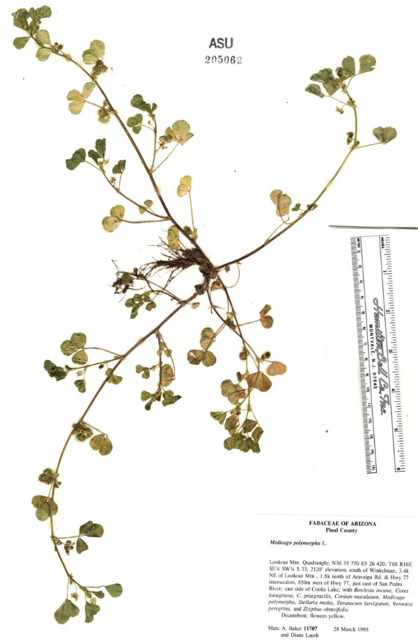
"dwc:startDayOfYear": "87",
"dwc:specificEpithet": "polymorpha",
"dwc:county": "Pinal County",
"dwc:recordedBy": "Marc A. Baker; Laush, D.",
"dwc:georeferenceSources": "+-0.5 miles, lat-long estimate",
"dwc:order": "Fabales",
"dcterms:references": "https://swbiodiversity.org/seinet/collections/individual/index.php?occid=658052",
"dwc:scientificNameAuthorship": "L.",
"dwc:occurrenceID": "9530eaf9-76d0-4fee-975c-c13f2ae3b0f6",
"dwc:verbatimCoordinates": "TRS: T06S R16E S33 SE1/4,SW1/4",
"id": "658052",
"dwc:taxonID": "188",
"dwc:stateProvince": "Arizona",
"dwc:eventDate": "1995-03-28",
"dwc:collectionID": "a2e32c87-d320-4a01-bafd-a9182ae2e191",
"dwc:country": "USA",
"dwc:collectionCode": "Plants",
"dwc:kingdom": "Plantae",
"dwc:decimalLatitude": "32.8675",
"dwc:occurrenceRemarks": "Decumbent; flowers yellow",
"dwc:maximumElevationInMeters": "646",
"dwc:basisOfRecord": "PreservedSpecimen",
"dwc:genus": "Medicago",
"dwc:family": "Fabaceae",
"dc:rights": "http://creativecommons.org/licenses/by-nc/3.0/",
"symbiota:recordID": "9530eaf9-76d0-4fee-975c-c13f2ae3b0f6",
"dwc:phylum": "Magnoliophyta",
"dwc:locality": "Lookout Mountain Quadrangle; N36 35 770 E5 26 420; south of Winkelman, 3.4k northeast of Lookout Mountain, 1.8k morth of Aravaipa Rd. & Hwy 77 interse4ction, 850m west of Hwy 77, just east of San Pedro River, east side of Cooks Lake",
"dwc:institutionCode": "ASU",
"dwc:taxonRank": "Species",
"dwc:higherClassification": "Plantae|Magnoliophyta|Eudicots|Core Eudicots|Fabids|Rosids|Fabales|Fabaceae|Medicago",
"dwc:month": "3",
"dwc:decimalLongitude": "-110.715",
"dwc:scientificName": "Medicago polymorpha",
"dwc:otherCatalogNumbers": "205062",
"dwc:recordNumber": "11707",
"dwc:minimumElevationInMeters": "646",
"dcterms:modified": "2022-01-03 12:20:00",
"dwc:associatedTaxa": "ecologicallyOccursWith: Bowlesia incana|ecologicallyOccursWith: Carex lanuginosa|ecologicallyOccursWith: C. praegracilis|ecologicallyOccursWith: Conium maculatum|ecologicallyOccursWith: Medicago polylmorpha|ecologicallyOccursWith: Stellaria media|ecologicallyOccursWith: Taraxacum laevigatum|ecologicallyOccursWith: Veronica peregrina|ecologicallyOccursWith: Ziziphus obtusifolia",
"dwc:day": "28",
"dwc:year": "1995"
},
"indexTerms": {
"geopoint": {
"lat": 32.8675,
"lon": -110.715
},
"family": "fabaceae",
"recordset": "40250f4d-7aa6-4fcc-ac38-2868fa4846bd",
"dqs": 0.2608695652173913,
"stateprovince": "arizona",
"county": "pinal county",
"phylum": "tracheophyta",
"startdayofyear": 87,
"taxonrank": "species",
"specificepithet": "polymorpha",
"continent": "north america",
"uuid": "2974d509-95dd-4f86-8b84-5cddc52eee73",
"countrycode": "usa",
"basisofrecord": "preservedspecimen",
"collector": "marc a. baker; laush, d.",
"institutioncode": "asu",
"mediarecords": [
"03219d74-5424-4b0d-8b0f-e7a720398104"
],
"datemodified": "2022-12-06T21:46:35.594653+00:00",
"datecollected": "1995-03-28T00:00:00+00:00",
"etag": "e90cef18c9d2d6b393cc2e13d8658c8d3fc416cd",
"recordnumber": "11707",
"minelevation": 646,
"hasImage": true,
"kingdom": "plantae",
"maxelevation": 646,
"highertaxon": "plantae|magnoliophyta|eudicots|core eudicots|fabids|rosids|fabales|fabaceae|medicago",
"collectionid": "a2e32c87-d320-4a01-bafd-a9182ae2e191",
"taxonid": "2965531",
"scientificname": "medicago polymorpha",
"indexData": {
"dwc:startDayOfYear": "87",
"flag_dwc_country_replaced": true,
"dwc:specificEpithet": "polymorpha",
"idigbio:dateModified": "2022-12-06T21:46:35.594653",
"dwc:county": "Pinal County",
"dwc:recordedBy": "Marc A. Baker; Laush, D.",
"idigbio:uuid": "2974d509-95dd-4f86-8b84-5cddc52eee73",
"dwc:locality": "Lookout Mountain Quadrangle; N36 35 770 E5 26 420; south of Winkelman, 3.4k northeast of Lookout Mountain, 1.8k morth of Aravaipa Rd. & Hwy 77 interse4ction, 850m west of Hwy 77, just east of San Pedro River, east side of Cooks Lake",
"dwc:order": "Fabales",
"dcterms:references": "https://swbiodiversity.org/seinet/collections/individual/index.php?occid=658052",
"flag_gbif_reference_added": true,
"dwc:scientificNameAuthorship": "L.",
"flag_dwc_taxonid_replaced": true,
"dwc:occurrenceID": "9530eaf9-76d0-4fee-975c-c13f2ae3b0f6",
"flag_dwc_taxonrank_replaced": true,
"dwc:verbatimCoordinates": "TRS: T06S R16E S33 SE1/4,SW1/4",
"flag_dwc_taxonomicstatus_added": true,
"flag_gbif_genericname_added": true,
"id": "658052",
"dwc:taxonID": "2965531",
"idigbio:parent": "40250f4d-7aa6-4fcc-ac38-2868fa4846bd",
"dwc:stateProvince": "Arizona",
"flag_gbif_taxon_corrected": true,
"dwc:eventDate": "1995-03-28",
"dwc:collectionID": "a2e32c87-d320-4a01-bafd-a9182ae2e191",
"dwc:country": "united states",
"dwc:multimedia": [
{
"dcterms:license": "creative commons attribution share alike 3.0 migrated",
"dcterms:references": "http://commons.wikimedia.org/wiki/file:medicago_polymorpha_(flower).jpg",
"coreid": "2965531",
"dcterms:identifier": "http://upload.wikimedia.org/wikipedia/commons/9/96/medicago_polymorpha_%28flower%29.jpg",
"dcterms:source": "english wikipedia - species pages",
"dcterms:description": "rauer schneckenklee (medicago polymorpha) - flower",
"dcterms:creator": "ixitixel",
"dcterms:publisher": "wikimedia commons"
}
],
"idigbio:etag": "e90cef18c9d2d6b393cc2e13d8658c8d3fc416cd",
"dwc:collectionCode": "Plants",
"flag_dwc_multimedia_added": true,
"dwc:class": "magnoliopsida",
"dwc:kingdom": "Plantae",
"dwc:decimalLatitude": "32.8675",
"dwc:occurrenceRemarks": "Decumbent; flowers yellow",
"dwc:maximumElevationInMeters": "646",
"dwc:basisOfRecord": "PreservedSpecimen",
"dwc:taxonomicstatus": "accepted",
"dwc:genus": "Medicago",
"dwc:continent": "north america",
"dwc:family": "Fabaceae",
"dc:rights": "http://creativecommons.org/licenses/by-nc/3.0/",
"flag_dwc_parentnameusageid_added": true,
"flag_dwc_datasetid_added": true,
"gbif:vernacularname": [
{
"coreid": "2965531",
"dcterms:source": "leguminosae in flora iberica",
"dwc:vernacularname": "alfalfa de secano, carretillas, carretón, carretón de amores, mielga de caracolillo, torteruelas"
},
{
"coreid": "2965531",
"dcterms:language": "en",
"dcterms:source": "catalogue of life",
"dwc:vernacularname": "black medick"
},
{
"coreid": "2965531",
"dcterms:language": "en",
"dcterms:source": "catalogue of life",
"dwc:vernacularname": "burclover"
},
{
"coreid": "2965531",
"dcterms:language": "en",
"dcterms:source": "integrated taxonomic information system (itis)",
"dwc:vernacularname": "burclover"
},
{
"coreid": "2965531",
"dcterms:source": "integrated taxonomic information system (itis)",
"dwc:vernacularname": "bur clover"
},
{
"coreid": "2965531",
"dcterms:language": "en",
"dcterms:source": "catalogue of life",
"dwc:vernacularname": "bur medic"
},
{
"coreid": "2965531",
"dcterms:language": "en",
"dcterms:source": "grin taxonomy",
"dwc:vernacularname": "bur medic"
},
{
"coreid": "2965531",
"dcterms:source": "catalogue of life",
"dwc:vernacularname": "bur medick"
},
{
"coreid": "2965531",
"dcterms:language": "en",
"dcterms:source": "integrated taxonomic information system (itis)",
"dwc:vernacularname": "bur medick"
},
{
"coreid": "2965531",
"dcterms:source": "catalogue of life",
"dwc:vernacularname": "burr medic"
},
{
"coreid": "2965531",
"dcterms:language": "en",
"dcterms:source": "database of vascular plants of canada (vascan)",
"dwc:vernacularname": "burr medic"
},
{
"coreid": "2965531",
"dcterms:language": "en",
"dcterms:source": "grin taxonomy",
"dwc:vernacularname": "bur trefoil"
},
{
"coreid": "2965531",
"dcterms:language": "en",
"dcterms:source": "catalogue of life",
"dwc:vernacularname": "california burclover"
},
{
"coreid": "2965531",
"dcterms:language": "en",
"dcterms:source": "grin taxonomy",
"dwc:vernacularname": "california bur-clover"
},
{
"coreid": "2965531",
"dcterms:source": "integrated taxonomic information system (itis)",
"dwc:vernacularname": "california burclover"
},
{
"coreid": "2965531",
"dcterms:language": "en",
"dcterms:source": "database of vascular plants of canada (vascan)",
"dwc:vernacularname": "california burr-clover"
},
{
"coreid": "2965531",
"dcterms:source": "leguminosae in flora iberica",
"dwc:vernacularname": "carrapiço, trevo-preto"
},
{
"coreid": "2965531",
"dcterms:language": "es",
"dcterms:source": "grin taxonomy",
"dwc:vernacularname": "carretón de amores"
},
{
"coreid": "2965531",
"dcterms:source": "grin taxonomy",
"dwc:vernacularname": "gaejari"
},
{
"coreid": "2965531",
"dcterms:language": "en",
"dcterms:source": "database of vascular plants of canada (vascan)",
"dwc:vernacularname": "hairy medic"
},
{
"coreid": "2965531",
"dcterms:language": "en",
"dcterms:source": "grin taxonomy",
"dwc:vernacularname": "hairy medic"
},
{
"coreid": "2965531",
"dcterms:source": "leguminosae in flora iberica",
"dwc:vernacularname": "herba do rosco, trebo caracol"
},
{
"coreid": "2965531",
"dcterms:source": "korean peninsula flora",
"dwc:vernacularname": "개자리"
},
{
"coreid": "2965531",
"dcterms:language": "fr",
"dcterms:source": "grin taxonomy",
"dwc:vernacularname": "luzerne hérissée"
},
{
"dwc:countrycode": "be",
"dwc:country": "belgium",
"dwc:vernacularname": "luzerne polymorphe",
"coreid": "2965531",
"dcterms:source": "belgian species list",
"dcterms:language": "fr"
},
{
"coreid": "2965531",
"dcterms:language": "fr",
"dcterms:source": "catalogue of life",
"dwc:vernacularname": "luzerne polymorphe"
},
{
"coreid": "2965531",
"dcterms:language": "fr",
"dcterms:source": "database of vascular plants of canada (vascan)",
"dwc:vernacularname": "luzerne polymorphe"
},
{
"dwc:countrycode": "ru",
"dwc:country": "russian federation",
"dwc:vernacularname": "lyutzerna chernaya",
"coreid": "2965531",
"dcterms:source": "catalogue of life",
"dcterms:language": "ru"
},
{
"dwc:countrycode": "ru",
"dwc:country": "russian federation",
"dwc:vernacularname": "lyutzerna melkozubchataya",
"coreid": "2965531",
"dcterms:source": "catalogue of life",
"dcterms:language": "ru"
},
{
"dwc:countrycode": "ru",
"dwc:country": "russian federation",
"dwc:vernacularname": "lyutzerna zubchataya",
"coreid": "2965531",
"dcterms:source": "catalogue of life",
"dcterms:language": "ru"
},
{
"coreid": "2965531",
"dcterms:language": "it",
"dcterms:source": "grin taxonomy",
"dwc:vernacularname": "medica ispida"
},
{
"coreid": "2965531",
"dcterms:source": "leguminosae in flora iberica",
"dwc:vernacularname": "melgó de llapassa"
},
{
"coreid": "2965531",
"dcterms:language": "en",
"dcterms:source": "database of vascular plants of canada (vascan)",
"dwc:vernacularname": "multi-formed medick"
},
{
"coreid": "2965531",
"dcterms:language": "ar",
"dcterms:source": "grin taxonomy",
"dwc:vernacularname": "nafal"
},
{
"coreid": "2965531",
"dcterms:source": "grin taxonomy",
"dwc:vernacularname": "nan mu xu"
},
{
"coreid": "2965531",
"dcterms:language": "de",
"dcterms:source": "catalogue of life",
"dwc:vernacularname": "rauher schneckenklee"
},
{
"coreid": "2965531",
"dcterms:language": "de",
"dcterms:source": "grin taxonomy",
"dwc:vernacularname": "rauher schneckenklee"
},
{
"coreid": "2965531",
"dcterms:language": "en",
"dcterms:source": "grin taxonomy",
"dwc:vernacularname": "rough medic"
},
{
"dwc:countrycode": "be",
"dwc:country": "belgium",
"dwc:vernacularname": "ruige rupsklaver",
"coreid": "2965531",
"dcterms:source": "belgian species list",
"dcterms:language": "nl"
},
{
"coreid": "2965531",
"dcterms:language": "nl",
"dcterms:source": "checklist dutch species catalog - nederlands soortenregister",
"dwc:vernacularname": "ruige rupsklaver"
},
{
"dwc:countrycode": "de",
"dwc:country": "germany",
"dwc:vernacularname": "schwarzer schneckenklee, rauher schneckenklee",
"coreid": "2965531",
"dcterms:source": "taxon list of vascular plants from bavaria, germany compiled in the context of the bfl project",
"dcterms:language": "de"
},
{
"coreid": "2965531",
"dcterms:language": "en",
"dcterms:source": "database of vascular plants of canada (vascan)",
"dwc:vernacularname": "smooth burr-clover"
},
{
"coreid": "2965531",
"dcterms:language": "de",
"dcterms:source": "catalogue of life",
"dwc:vernacularname": "stachliger schneckenklee"
},
{
"coreid": "2965531",
"dcterms:language": "sv",
"dcterms:source": "grin taxonomy",
"dwc:vernacularname": "tagglusern"
},
{
"coreid": "2965531",
"dcterms:language": "en",
"dcterms:source": "catalogue of life",
"dwc:vernacularname": "toothed bur clover"
},
{
"coreid": "2965531",
"dcterms:language": "en",
"dcterms:source": "grin taxonomy",
"dwc:vernacularname": "toothed bur-clover"
},
{
"coreid": "2965531",
"dcterms:language": "en",
"dcterms:source": "database of vascular plants of canada (vascan)",
"dwc:vernacularname": "toothed burr-clover"
},
{
"coreid": "2965531",
"dcterms:language": "en",
"dcterms:source": "database of vascular plants of canada (vascan)",
"dwc:vernacularname": "toothed medic"
},
{
"coreid": "2965531",
"dcterms:language": "en",
"dcterms:source": "grin taxonomy",
"dwc:vernacularname": "toothed medic"
},
{
"coreid": "2965531",
"dcterms:language": "en",
"dcterms:source": "catalogue of life",
"dwc:vernacularname": "toothed medick"
},
{
"coreid": "2965531",
"dcterms:language": "en",
"dcterms:source": "database of vascular plants of canada (vascan)",
"dwc:vernacularname": "toothed medick"
},
{
"coreid": "2965531",
"dcterms:language": "en",
"dcterms:source": "grin taxonomy",
"dwc:vernacularname": "toothed medick"
},
{
"coreid": "2965531",
"dcterms:source": "integrated taxonomic information system (itis)",
"dwc:vernacularname": "toothed medick"
},
{
"coreid": "2965531",
"dcterms:language": "es",
"dcterms:source": "grin taxonomy",
"dwc:vernacularname": "trébol de carretilla"
},
{
"coreid": "2965531",
"dcterms:language": "en",
"dcterms:source": "grin taxonomy",
"dwc:vernacularname": "trefoil-clover"
},
{
"coreid": "2965531",
"dcterms:source": "leguminosae in flora iberica",
"dwc:vernacularname": "trèvol destormia, trèvol de llapassa, trèvol de llapassó"
},
{
"coreid": "2965531",
"dcterms:source": "grin taxonomy",
"dwc:vernacularname": "uma-goyashi"
},
{
"coreid": "2965531",
"dcterms:language": "de",
"dcterms:source": "catalogue of life",
"dwc:vernacularname": "wollklette"
}
],
"idigbio:isocountrycode": "usa",
"idigbio:siblings": {
"mediarecord": [
"03219d74-5424-4b0d-8b0f-e7a720398104"
]
},
"symbiota:recordID": "9530eaf9-76d0-4fee-975c-c13f2ae3b0f6",
"flag_idigbio_isocountrycode_added": true,
"gbif:canonicalname": "medicago polymorpha",
"dwc:phylum": "tracheophyta",
"gbif:genericname": "medicago",
"dwc:georeferenceSources": "+-0.5 miles, lat-long estimate",
"flag_gbif_vernacularname_added": true,
"dwc:institutionCode": "ASU",
"dwc:taxonRank": "species",
"dwc:parentnameusageid": "2965200",
"dwc:higherClassification": "Plantae|Magnoliophyta|Eudicots|Core Eudicots|Fabids|Rosids|Fabales|Fabaceae|Medicago",
"flag_dwc_phylum_replaced": true,
"flag_gbif_canonicalname_added": true,
"dwc:month": "3",
"dwc:decimalLongitude": "-110.715",
"dwc:associatedTaxa": "ecologicallyOccursWith: Bowlesia incana|ecologicallyOccursWith: Carex lanuginosa|ecologicallyOccursWith: C. praegracilis|ecologicallyOccursWith: Conium maculatum|ecologicallyOccursWith: Medicago polylmorpha|ecologicallyOccursWith: Stellaria media|ecologicallyOccursWith: Taraxacum laevigatum|ecologicallyOccursWith: Veronica peregrina|ecologicallyOccursWith: Ziziphus obtusifolia",
"dwc:otherCatalogNumbers": "205062",
"gbif:reference": [
{
"coreid": "2965531",
"dcterms:source": "catalogue of life",
"dcterms:bibliographiccitation": "ali,s.i. (1977) papilion. in:flora of west pakistan, no 100."
},
{
"coreid": "2965531",
"dcterms:source": "catalogue of life",
"dcterms:bibliographiccitation": "greuter,w. et al. (eds.) (1989) med-checklist vol.4 (published)"
},
{
"coreid": "2965531",
"dcterms:source": "catalogue of life",
"dcterms:bibliographiccitation": "heywood,v.h. & ball,p.w. (1968) leguminosae.in:flora europaea vol.2.ed.tutin,t.g.et al."
},
{
"coreid": "2965531",
"dcterms:source": "catalogue of life",
"dcterms:bibliographiccitation": "linnaeus,c.von (1753) sp.pl."
},
{
"coreid": "2965531",
"dcterms:source": "catalogue of life",
"dcterms:bibliographiccitation": "polhill,r,m. (1990) legumineuses.in:flore des mascareignes,vol 80.j. bosser et a"
},
{
"coreid": "2965531",
"dcterms:source": "catalogue of life",
"dcterms:bibliographiccitation": "prain,d. (1903) bengal plants vol 1"
},
{
"coreid": "2965531",
"dcterms:source": "catalogue of life",
"dcterms:bibliographiccitation": "roskov,yu.r. (2004) pers. com."
},
{
"coreid": "2965531",
"dcterms:source": "catalogue of life",
"dcterms:bibliographiccitation": "small,e. & jomphe,m. (1989) a synopsis of the genus medicago. can.j.bot 67:3260-3294"
},
{
"coreid": "2965531",
"dcterms:source": "catalogue of life",
"dcterms:bibliographiccitation": "thuan,n. et al. (1987) in: flore du cambodge, du laos et du vietnam, vol. 23.p."
},
{
"coreid": "2965531",
"dcterms:source": "taxa watermanagement the netherlands (twn)",
"dcterms:bibliographiccitation": "van der meijden, r. (2005)"
},
{
"coreid": "2965531",
"dcterms:source": "catalogue of life",
"dcterms:bibliographiccitation": "van thuan,dy phon & niyomdham (1987) flore du cambodge, du laos et du vietnam 23 - papilionoidees"
},
{
"coreid": "2965531",
"dcterms:source": "catalogue of life",
"dcterms:bibliographiccitation": "wei,z. & huang,y.z. (1998) galega &... in: fl.reip.pop.sinicae, 42(2) (leguminosae 5)"
}
],
"flag_dwc_continent_added": true,
"idigbio:recordIds": [
"urn:uuid:9530eaf9-76d0-4fee-975c-c13f2ae3b0f6",
"40250f4d-7aa6-4fcc-ac38-2868fa4846bd\\urn:uuid:9530eaf9-76d0-4fee-975c-c13f2ae3b0f6",
"40250f4d-7aa6-4fcc-ac38-2868fa4846bd\\658052",
"40250f4d-7aa6-4fcc-ac38-2868fa4846bd\\9530eaf9-76d0-4fee-975c-c13f2ae3b0f6"
],
"dwc:recordNumber": "11707",
"dwc:datasetid": "7ddf754f-d193-4cc9-b351-99906754a03b",
"flag_dwc_class_added": true,
"dwc:minimumElevationInMeters": "646",
"dcterms:modified": "2022-01-03 12:20:00",
"dwc:scientificName": "Medicago polymorpha",
"dwc:day": "28",
"dwc:year": "1995"
},
"hasMedia": true,
"class": "magnoliopsida",
"occurrenceid": "9530eaf9-76d0-4fee-975c-c13f2ae3b0f6",
"country": "united states",
"locality": "lookout mountain quadrangle; n36 35 770 e5 26 420; south of winkelman, 3.4k northeast of lookout mountain, 1.8k morth of aravaipa rd. & hwy 77 interse4ction, 850m west of hwy 77, just east of san pedro river, east side of cooks lake",
"collectioncode": "plants",
"canonicalname": "medicago polymorpha",
"eventdate": "1995-03-28",
"flags": [
"geopoint_datum_missing",
"dwc_country_replaced",
"gbif_reference_added",
"dwc_taxonid_replaced",
"dwc_taxonrank_replaced",
"dwc_taxonomicstatus_added",
"gbif_genericname_added",
"gbif_taxon_corrected",
"dwc_multimedia_added",
"dwc_parentnameusageid_added",
"dwc_datasetid_added",
"idigbio_isocountrycode_added",
"gbif_vernacularname_added",
"dwc_phylum_replaced",
"gbif_canonicalname_added",
"dwc_continent_added",
"dwc_class_added"
],
"taxonomicstatus": "accepted",
"recordids": [
"urn:uuid:9530eaf9-76d0-4fee-975c-c13f2ae3b0f6",
"40250f4d-7aa6-4fcc-ac38-2868fa4846bd\\urn:uuid:9530eaf9-76d0-4fee-975c-c13f2ae3b0f6",
"40250f4d-7aa6-4fcc-ac38-2868fa4846bd\\658052",
"40250f4d-7aa6-4fcc-ac38-2868fa4846bd\\9530eaf9-76d0-4fee-975c-c13f2ae3b0f6"
],
"genus": "medicago",
"order": "fabales",
"datasetid": "7ddf754f-d193-4cc9-b351-99906754a03b"
},
"attribution": {
"totalCount": 283567
}
}