{
"uuid": "23637ea6-f15e-4aca-b676-6b9544537a42",
"type": "records",
"etag": "ccde762532962be4557178b38c2573463846bd66",
"data": {
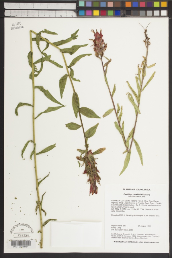
"dwc:startDayOfYear": "236",
"dwc:specificEpithet": "rhexiifolia",
"dwc:county": "Franklin",
"dwc:recordedBy": "Allyson Davis; Sandy Long",
"dwc:order": "Lamiales",
"dwc:habitat": "Growing at the edges of the forested area.",
"dwc:scientificNameAuthorship": "Rydb.",
"dwc:occurrenceID": "USU:UTC:228154",
"id": "236331",
"dwc:taxonID": "18021",
"dwc:stateProvince": "Idaho",
"dwc:eventDate": "1999-08-24",
"dwc:collectionID": "06bf658d-f555-4c9c-ab93-fc2d7db7086e",
"dwc:country": "United States",
"dwc:collectionCode": "UTC",
"dcterms:rightsHolder": "Utah State University",
"dwc:kingdom": "Plantae",
"dwc:decimalLatitude": "42.04",
"dwc:basisOfRecord": "PreservedSpecimen",
"dwc:genus": "Castilleja",
"dwc:family": "Scrophulariaceae",
"dc:rights": "http://creativecommons.org/publicdomain/zero/1.0/",
"symbiota:recordID": "1c1e5e09-8959-4546-be94-0722d939e088",
"dwc:phylum": "Magnoliophyta",
"dcterms:references": "https://intermountainbiota.org/portal/collections/individual/index.php?occid=236331",
"dwc:locality": "Cache National Forest ; Bear River Range: Highway 89 up Logan Canyon to Franklin Basin Road. Franklin Basin Road to Gibson Lakes. Ca. 0.125 mi",
"dwc:institutionCode": "Utah State University",
"dwc:taxonRank": "Species",
"dwc:higherClassification": "Plantae|Magnoliophyta|Eudicots|Core Eudicots|Lamiids|Asterids|Lamiales|Orobanchaceae|Castilleja",
"dwc:catalogNumber": "UTC00228154",
"dwc:month": "8",
"dwc:decimalLongitude": "-111.6380556",
"dwc:recordNumber": "517",
"dwc:minimumElevationInMeters": "2621",
"dcterms:modified": "2020-05-25 10:15:37",
"dwc:scientificName": "Castilleja rhexiifolia",
"dwc:day": "24",
"dwc:year": "1999"
},
"indexTerms": {
"geopoint": {
"lat": 42.04,
"lon": -111.6380556
},
"family": "orobanchaceae",
"recordset": "215eeaf0-0a88-409e-a75d-aec98b7c41eb",
"dqs": 0.21739130434782608,
"stateprovince": "idaho",
"county": "franklin",
"phylum": "tracheophyta",
"catalognumber": "utc00228154",
"startdayofyear": 236,
"taxonrank": "species",
"specificepithet": "rhexifolia",
"continent": "north america",
"uuid": "23637ea6-f15e-4aca-b676-6b9544537a42",
"countrycode": "usa",
"basisofrecord": "preservedspecimen",
"collector": "allyson davis; sandy long",
"institutioncode": "utah state university",
"mediarecords": [
"21c69884-3670-42fb-8c39-7e1490914ff8"
],
"datemodified": "2022-12-06T21:46:54.888074+00:00",
"datecollected": "1999-08-24T00:00:00+00:00",
"etag": "ccde762532962be4557178b38c2573463846bd66",
"recordnumber": "517",
"minelevation": 2621,
"hasImage": true,
"kingdom": "plantae",
"highertaxon": "plantae|magnoliophyta|eudicots|core eudicots|lamiids|asterids|lamiales|orobanchaceae|castilleja",
"collectionid": "06bf658d-f555-4c9c-ab93-fc2d7db7086e",
"taxonid": "8034551",
"scientificname": "castilleja rhexiifolia",
"indexData": {
"dwc:startDayOfYear": "236",
"flag_dwc_family_replaced": true,
"dwc:specificEpithet": "rhexifolia",
"idigbio:dateModified": "2022-12-06T21:46:54.888074",
"dwc:county": "Franklin",
"dwc:recordedBy": "Allyson Davis; Sandy Long",
"idigbio:uuid": "23637ea6-f15e-4aca-b676-6b9544537a42",
"flag_dwc_multimedia_added": true,
"dwc:order": "Lamiales",
"dwc:habitat": "Growing at the edges of the forested area.",
"flag_gbif_reference_added": true,
"dwc:scientificNameAuthorship": "rydb.",
"flag_dwc_taxonid_replaced": true,
"dwc:occurrenceID": "USU:UTC:228154",
"flag_dwc_taxonrank_replaced": true,
"flag_dwc_specificepithet_replaced": true,
"flag_dwc_taxonomicstatus_added": true,
"flag_gbif_genericname_added": true,
"dcterms:rightsHolder": "Utah State University",
"dwc:taxonID": "8034551",
"idigbio:parent": "215eeaf0-0a88-409e-a75d-aec98b7c41eb",
"dwc:stateProvince": "Idaho",
"flag_gbif_taxon_corrected": true,
"dwc:eventDate": "1999-08-24",
"flag_dwc_scientificnameauthorship_replaced": true,
"dwc:collectionID": "06bf658d-f555-4c9c-ab93-fc2d7db7086e",
"dwc:country": "United States",
"dwc:multimedia": [
{
"dcterms:license": "public domain images from the u.s. national park service",
"dcterms:title": "castilleja spec.",
"dcterms:references": "http://commons.wikimedia.org/wiki/file:indian_paintbrush_in_grand_teton_np-nps.jpg",
"coreid": "3170565",
"dcterms:identifier": "http://upload.wikimedia.org/wikipedia/commons/7/79/indian_paintbrush_in_grand_teton_np-nps.jpg",
"dcterms:source": "german wikipedia - species pages",
"dcterms:publisher": "wikimedia commons"
},
{
"dcterms:license": "creative commons attribution share alike 3.0 unported",
"dcterms:title": "castilleja miniata",
"dcterms:references": "http://commons.wikimedia.org/wiki/file:red_paintbrush_castilleja_miniata_close.jpg",
"coreid": "3170565",
"dcterms:identifier": "http://upload.wikimedia.org/wikipedia/commons/f/fa/red_paintbrush_castilleja_miniata_close.jpg",
"dcterms:source": "english wikipedia - species pages",
"dcterms:description": "english: common red indian paintbrush (castilleja miniata), closeup, with flowers and stamens protruding from the red bracts. in grass by upper rock creek at 10,350ft, little lakes valley, john muir wilderness, sierra nevada mountains, california.",
"dcterms:creator": "dcrjsr",
"dcterms:publisher": "wikimedia commons"
}
],
"idigbio:etag": "ccde762532962be4557178b38c2573463846bd66",
"dwc:collectionCode": "UTC",
"id": "236331",
"dwc:kingdom": "Plantae",
"dwc:decimalLatitude": "42.04",
"dwc:basisOfRecord": "PreservedSpecimen",
"dwc:taxonomicstatus": "accepted",
"dwc:genus": "Castilleja",
"dwc:continent": "north america",
"dwc:family": "orobanchaceae",
"dc:rights": "http://creativecommons.org/publicdomain/zero/1.0/",
"flag_dwc_parentnameusageid_added": true,
"flag_dwc_datasetid_added": true,
"dwc:class": "magnoliopsida",
"idigbio:isocountrycode": "usa",
"idigbio:siblings": {
"mediarecord": [
"21c69884-3670-42fb-8c39-7e1490914ff8"
]
},
"symbiota:recordID": "1c1e5e09-8959-4546-be94-0722d939e088",
"flag_idigbio_isocountrycode_added": true,
"gbif:canonicalname": "castilleja rhexifolia",
"dwc:phylum": "tracheophyta",
"dcterms:references": "https://intermountainbiota.org/portal/collections/individual/index.php?occid=236331",
"gbif:genericname": "castilleja",
"dwc:locality": "Cache National Forest ; Bear River Range: Highway 89 up Logan Canyon to Franklin Basin Road. Franklin Basin Road to Gibson Lakes. Ca. 0.125 mi",
"flag_gbif_vernacularname_added": true,
"dwc:institutionCode": "Utah State University",
"dwc:taxonRank": "species",
"dwc:parentnameusageid": "3170565",
"dwc:higherClassification": "Plantae|Magnoliophyta|Eudicots|Core Eudicots|Lamiids|Asterids|Lamiales|Orobanchaceae|Castilleja",
"dwc:catalogNumber": "UTC00228154",
"flag_dwc_phylum_replaced": true,
"flag_gbif_canonicalname_added": true,
"dwc:month": "8",
"dwc:decimalLongitude": "-111.6380556",
"gbif:vernacularname": [
{
"coreid": "8034551",
"dcterms:language": "en",
"dcterms:source": "database of vascular plants of canada (vascan)",
"dwc:vernacularname": "alpine paintbrush"
},
{
"coreid": "8034551",
"dcterms:language": "fr",
"dcterms:source": "database of vascular plants of canada (vascan)",
"dwc:vernacularname": "castilléjie à feuilles de rhéxie"
},
{
"coreid": "8034551",
"dcterms:source": "integrated taxonomic information system (itis)",
"dwc:vernacularname": "rhexialeaf paintbrush"
},
{
"coreid": "8034551",
"dcterms:language": "en",
"dcterms:source": "database of vascular plants of canada (vascan)",
"dwc:vernacularname": "rhexia-leaved paintbrush"
},
{
"coreid": "8034551",
"dcterms:language": "en",
"dcterms:source": "database of vascular plants of canada (vascan)",
"dwc:vernacularname": "rocky mountain paintbrush"
},
{
"coreid": "8034551",
"dcterms:language": "en",
"dcterms:source": "database of vascular plants of canada (vascan)",
"dwc:vernacularname": "rosy paintbrush"
},
{
"coreid": "8034551",
"dcterms:source": "catalogue of life",
"dwc:vernacularname": "splitleaf indian paintbrush"
},
{
"coreid": "8034551",
"dcterms:language": "en",
"dcterms:source": "integrated taxonomic information system (itis)",
"dwc:vernacularname": "splitleaf indian paintbrush"
},
{
"coreid": "8034551",
"dcterms:language": "en",
"dcterms:source": "database of vascular plants of canada (vascan)",
"dwc:vernacularname": "split-leaved indian paintbrush"
},
{
"coreid": "8034551",
"dcterms:language": "en",
"dcterms:source": "database of vascular plants of canada (vascan)",
"dwc:vernacularname": "split-leaved paintbrush"
}
],
"gbif:reference": [
{
"coreid": "8034551",
"dcterms:source": "catalogue of life",
"dcterms:bibliographiccitation": "rydb. (1900) in: mem. n. york bot. gard. 1: 356"
}
],
"flag_dwc_continent_added": true,
"idigbio:recordIds": [
"urn:uuid:1c1e5e09-8959-4546-be94-0722d939e088",
"215eeaf0-0a88-409e-a75d-aec98b7c41eb\\236331",
"215eeaf0-0a88-409e-a75d-aec98b7c41eb\\usu:utc:228154",
"215eeaf0-0a88-409e-a75d-aec98b7c41eb\\urn:uuid:1c1e5e09-8959-4546-be94-0722d939e088",
"215eeaf0-0a88-409e-a75d-aec98b7c41eb\\1c1e5e09-8959-4546-be94-0722d939e088"
],
"dwc:recordNumber": "517",
"dwc:datasetid": "7ddf754f-d193-4cc9-b351-99906754a03b",
"flag_dwc_class_added": true,
"dwc:minimumElevationInMeters": "2621",
"dcterms:modified": "2020-05-25 10:15:37",
"dwc:scientificName": "Castilleja rhexiifolia",
"dwc:day": "24",
"dwc:year": "1999"
},
"hasMedia": true,
"class": "magnoliopsida",
"occurrenceid": "usu:utc:228154",
"country": "united states",
"locality": "cache national forest ; bear river range: highway 89 up logan canyon to franklin basin road. franklin basin road to gibson lakes. ca. 0.125 mi",
"collectioncode": "utc",
"canonicalname": "castilleja rhexifolia",
"eventdate": "1999-08-24",
"flags": [
"geopoint_datum_missing",
"geopoint_low_precision",
"dwc_family_replaced",
"dwc_multimedia_added",
"gbif_reference_added",
"dwc_taxonid_replaced",
"dwc_taxonrank_replaced",
"dwc_specificepithet_replaced",
"dwc_taxonomicstatus_added",
"gbif_genericname_added",
"gbif_taxon_corrected",
"dwc_scientificnameauthorship_replaced",
"dwc_parentnameusageid_added",
"dwc_datasetid_added",
"idigbio_isocountrycode_added",
"gbif_vernacularname_added",
"dwc_phylum_replaced",
"gbif_canonicalname_added",
"dwc_continent_added",
"dwc_class_added"
],
"taxonomicstatus": "accepted",
"recordids": [
"urn:uuid:1c1e5e09-8959-4546-be94-0722d939e088",
"215eeaf0-0a88-409e-a75d-aec98b7c41eb\\236331",
"215eeaf0-0a88-409e-a75d-aec98b7c41eb\\usu:utc:228154",
"215eeaf0-0a88-409e-a75d-aec98b7c41eb\\urn:uuid:1c1e5e09-8959-4546-be94-0722d939e088",
"215eeaf0-0a88-409e-a75d-aec98b7c41eb\\1c1e5e09-8959-4546-be94-0722d939e088"
],
"genus": "castilleja",
"order": "lamiales",
"datasetid": "7ddf754f-d193-4cc9-b351-99906754a03b"
},
"attribution": {
"totalCount": 186686
}
}