{
"uuid": "2359b5f6-36c2-419b-b857-3b92c052c53b",
"type": "records",
"etag": "3583f1e4f2ba4472e1c65fd6df9e915de60adea1",
"data": {
"dwc:startDayOfYear": "130",
"dwc:verbatimTaxonRank": "var.",
"dwc:specificEpithet": "octoflora",
"dwc:county": "Garfield",
"dwc:recordedBy": "Walter Gertig, Debi Clark, and Chris Groebner",
"dwc:georeferenceSources": "TRS2LL",
"dwc:order": "Poales",
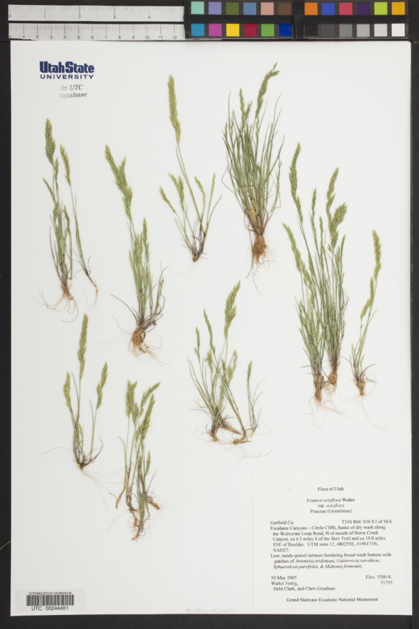
"dwc:habitat": "Low, sandy-gravel terraces bordering broad wash bottom with patches of Atremisia tridentata, Gutierreia sarothrae, sphaeralcea parvifolia, & Mahonia fremontii.",
"dwc:occurrenceID": "USU:UTC:244451",
"id": "251127",
"dwc:taxonID": "216919",
"dwc:stateProvince": "Utah",
"dwc:eventDate": "2005-05-10",
"dwc:collectionID": "06bf658d-f555-4c9c-ab93-fc2d7db7086e",
"dwc:country": "United States",
"dwc:collectionCode": "UTC",
"dcterms:rightsHolder": "Utah State University",
"dwc:kingdom": "Plantae",
"dwc:decimalLatitude": "37.8652",
"dwc:basisOfRecord": "PreservedSpecimen",
"dwc:genus": "Festuca",
"dwc:family": "Poaceae",
"dc:rights": "http://creativecommons.org/publicdomain/zero/1.0/",
"symbiota:recordID": "d9e33519-c812-4288-9f38-cb9716844252",
"dwc:infraspecificEpithet": "octoflora",
"dwc:phylum": "Magnoliophyta",
"dcterms:references": "https://intermountainbiota.org/portal/collections/individual/index.php?occid=251127",
"dwc:locality": "Escalante Canyons-Circle Cliffs, banks of dry wash along the Wolverine Loop Road, N of mouth of Horse Creek Canyon, ca 4.5 miles S of the Burr Trail and ca 10.8 miles ESE of Boulder",
"dwc:institutionCode": "Utah State University",
"dwc:taxonRank": "Variety",
"dwc:reproductiveCondition": "Unknown",
"dwc:higherClassification": "Plantae|Magnoliophyta|Monocots|Commelinids|Poales|Poaceae|Festuca|Festuca octoflora",
"dwc:catalogNumber": "UTC00244451",
"dwc:month": "5",
"dwc:decimalLongitude": "-111.231",
"dwc:recordNumber": "21755",
"dwc:minimumElevationInMeters": "1676",
"dcterms:modified": "2016-11-30 11:49:51",
"dwc:scientificName": "Festuca octoflora var. octoflora",
"dwc:day": "10",
"dwc:year": "2005"
},
"indexTerms": {
"geopoint": {
"lat": 37.8652,
"lon": -111.231
},
"family": "poaceae",
"recordset": "215eeaf0-0a88-409e-a75d-aec98b7c41eb",
"dqs": 0.2463768115942029,
"stateprovince": "utah",
"collectioncode": "utc",
"county": "garfield",
"phylum": "tracheophyta",
"catalognumber": "utc00244451",
"startdayofyear": 130,
"taxonrank": "species",
"specificepithet": "octoflora",
"continent": "north america",
"uuid": "2359b5f6-36c2-419b-b857-3b92c052c53b",
"countrycode": "usa",
"basisofrecord": "preservedspecimen",
"collector": "walter gertig, debi clark, and chris groebner",
"institutioncode": "utah state university",
"mediarecords": [
"5cf9a866-20dd-4d39-9bfa-415198f1f539"
],
"datemodified": "2022-12-06T21:46:54.888074+00:00",
"datecollected": "2005-05-10T00:00:00+00:00",
"etag": "3583f1e4f2ba4472e1c65fd6df9e915de60adea1",
"recordnumber": "21755",
"minelevation": 1676,
"hasImage": true,
"kingdom": "plantae",
"highertaxon": "plantae|magnoliophyta|monocots|commelinids|poales|poaceae|festuca|festuca octoflora",
"collectionid": "06bf658d-f555-4c9c-ab93-fc2d7db7086e",
"taxonid": "5289597",
"scientificname": "festuca octoflora var. octoflora",
"indexData": {
"dwc:startDayOfYear": "130",
"dwc:verbatimTaxonRank": "var.",
"dwc:specificEpithet": "octoflora",
"idigbio:dateModified": "2022-12-06T21:46:54.888074",
"dwc:county": "Garfield",
"dwc:recordedBy": "Walter Gertig, Debi Clark, and Chris Groebner",
"idigbio:uuid": "2359b5f6-36c2-419b-b857-3b92c052c53b",
"dwc:locality": "Escalante Canyons-Circle Cliffs, banks of dry wash along the Wolverine Loop Road, N of mouth of Horse Creek Canyon, ca 4.5 miles S of the Burr Trail and ca 10.8 miles ESE of Boulder",
"dwc:order": "Poales",
"dwc:habitat": "Low, sandy-gravel terraces bordering broad wash bottom with patches of Atremisia tridentata, Gutierreia sarothrae, sphaeralcea parvifolia, & Mahonia fremontii.",
"flag_gbif_reference_added": true,
"flag_dwc_scientificnameauthorship_added": true,
"flag_dwc_taxonid_replaced": true,
"dwc:occurrenceID": "USU:UTC:244451",
"flag_dwc_taxonrank_replaced": true,
"flag_dwc_taxonomicstatus_added": true,
"flag_gbif_genericname_added": true,
"dcterms:rightsHolder": "Utah State University",
"dwc:taxonID": "5289597",
"idigbio:parent": "215eeaf0-0a88-409e-a75d-aec98b7c41eb",
"dwc:stateProvince": "Utah",
"flag_gbif_taxon_corrected": true,
"dwc:parentnameusageid": "2702722",
"dwc:eventDate": "2005-05-10",
"dwc:collectionID": "06bf658d-f555-4c9c-ab93-fc2d7db7086e",
"dwc:country": "United States",
"dwc:multimedia": [
{
"dcterms:license": "creative commons attribution share alike",
"dcterms:references": "http://commons.wikimedia.org/wiki/file:vulpia_octoflora_(3990319536).jpg",
"coreid": "5289597",
"dcterms:identifier": "http://upload.wikimedia.org/wikipedia/commons/2/22/vulpia_octoflora_%283990319536%29.jpg",
"dcterms:source": "english wikipedia - species pages",
"dcterms:description": "english: vulpia octoflora in norris, montana, usa. \"the spikelets of vulpia are often slightly pedicellate and arranged in a secund fashionn along the main inflorescence rachis. like other fescue grasses, the florets are typically rounded across the back and separate from each other along long rachilla internodes.\"",
"dcterms:creator": "matt lavin",
"dcterms:publisher": "wikimedia commons"
}
],
"idigbio:etag": "3583f1e4f2ba4472e1c65fd6df9e915de60adea1",
"dwc:collectionCode": "UTC",
"flag_dwc_multimedia_added": true,
"id": "251127",
"dwc:kingdom": "Plantae",
"dwc:decimalLatitude": "37.8652",
"dwc:originalnameusageid": "4113111",
"dwc:basisOfRecord": "PreservedSpecimen",
"dwc:taxonomicstatus": "accepted",
"dwc:genus": "vulpia",
"dwc:continent": "north america",
"dwc:family": "Poaceae",
"dc:rights": "http://creativecommons.org/publicdomain/zero/1.0/",
"flag_dwc_parentnameusageid_added": true,
"flag_dwc_datasetid_added": true,
"dwc:class": "liliopsida",
"gbif:canonicalname": "vulpia octoflora",
"idigbio:isocountrycode": "usa",
"idigbio:siblings": {
"mediarecord": [
"5cf9a866-20dd-4d39-9bfa-415198f1f539"
]
},
"symbiota:recordID": "d9e33519-c812-4288-9f38-cb9716844252",
"flag_idigbio_isocountrycode_added": true,
"dwc:infraspecificEpithet": "octoflora",
"dwc:scientificnameauthorship": "rydb. (walter)",
"dwc:phylum": "tracheophyta",
"dcterms:references": "https://intermountainbiota.org/portal/collections/individual/index.php?occid=251127",
"gbif:genericname": "vulpia",
"dwc:georeferenceSources": "TRS2LL",
"flag_gbif_vernacularname_added": true,
"dwc:institutionCode": "Utah State University",
"dwc:taxonRank": "species",
"dwc:reproductiveCondition": "Unknown",
"dwc:higherClassification": "Plantae|Magnoliophyta|Monocots|Commelinids|Poales|Poaceae|Festuca|Festuca octoflora",
"dwc:catalogNumber": "UTC00244451",
"flag_dwc_phylum_replaced": true,
"flag_gbif_canonicalname_added": true,
"dwc:month": "5",
"dwc:decimalLongitude": "-111.231",
"gbif:vernacularname": [
{
"coreid": "5289597",
"dcterms:language": "en",
"dcterms:source": "database of vascular plants of canada (vascan)",
"dwc:vernacularname": "eight-flowered fescue"
},
{
"coreid": "5289597",
"dcterms:language": "en",
"dcterms:source": "database of vascular plants of canada (vascan)",
"dwc:vernacularname": "eight-flowered six-weeks grass"
},
{
"coreid": "5289597",
"dcterms:source": "integrated taxonomic information system (itis)",
"dwc:vernacularname": "eight-flower six-weeks grass"
},
{
"coreid": "5289597",
"dcterms:language": "fr",
"dcterms:source": "database of vascular plants of canada (vascan)",
"dwc:vernacularname": "fétuque octoflore"
},
{
"coreid": "5289597",
"dcterms:language": "en",
"dcterms:source": "database of vascular plants of canada (vascan)",
"dwc:vernacularname": "pullout grass"
},
{
"coreid": "5289597",
"dcterms:source": "integrated taxonomic information system (itis)",
"dwc:vernacularname": "pullout grass"
},
{
"coreid": "5289597",
"dcterms:language": "en",
"dcterms:source": "database of vascular plants of canada (vascan)",
"dwc:vernacularname": "six-weeks fescue"
},
{
"coreid": "5289597",
"dcterms:language": "en",
"dcterms:source": "grin taxonomy",
"dwc:vernacularname": "six-weeks fescue"
},
{
"coreid": "5289597",
"dcterms:source": "integrated taxonomic information system (itis)",
"dwc:vernacularname": "sixweeks fescue"
},
{
"coreid": "5289597",
"dcterms:source": "integrated taxonomic information system (itis)",
"dwc:vernacularname": "sixweeks grass"
},
{
"coreid": "5289597",
"dcterms:language": "fr",
"dcterms:source": "database of vascular plants of canada (vascan)",
"dwc:vernacularname": "vulpie octoflore"
}
],
"gbif:reference": [
{
"coreid": "5289597",
"dcterms:source": "catalogue of life",
"dcterms:bibliographiccitation": "rydb. (1909) in: bull. torrey bot. club 36: 538"
},
{
"coreid": "5289597",
"dcterms:source": "the plant list with literature",
"dcterms:bibliographiccitation": "rydberg pa (1909) studies on the rocky mountain flora-xix. bulletin of the torrey botanical club 36: 531-541. doi: 10.2307/2479292."
}
],
"flag_dwc_continent_added": true,
"idigbio:recordIds": [
"urn:uuid:d9e33519-c812-4288-9f38-cb9716844252",
"215eeaf0-0a88-409e-a75d-aec98b7c41eb\\251127",
"215eeaf0-0a88-409e-a75d-aec98b7c41eb\\usu:utc:244451",
"215eeaf0-0a88-409e-a75d-aec98b7c41eb\\urn:uuid:d9e33519-c812-4288-9f38-cb9716844252",
"215eeaf0-0a88-409e-a75d-aec98b7c41eb\\d9e33519-c812-4288-9f38-cb9716844252"
],
"dwc:recordNumber": "21755",
"dwc:datasetid": "7ddf754f-d193-4cc9-b351-99906754a03b",
"flag_dwc_originalnameusageid_added": true,
"flag_dwc_class_added": true,
"dwc:minimumElevationInMeters": "1676",
"dcterms:modified": "2016-11-30 11:49:51",
"dwc:scientificName": "Festuca octoflora var. octoflora",
"dwc:day": "10",
"flag_dwc_genus_replaced": true,
"dwc:year": "2005"
},
"hasMedia": true,
"class": "liliopsida",
"occurrenceid": "usu:utc:244451",
"country": "united states",
"locality": "escalante canyons-circle cliffs, banks of dry wash along the wolverine loop road, n of mouth of horse creek canyon, ca 4.5 miles s of the burr trail and ca 10.8 miles ese of boulder",
"infraspecificepithet": "octoflora",
"canonicalname": "vulpia octoflora",
"eventdate": "2005-05-10",
"flags": [
"geopoint_datum_missing",
"gbif_reference_added",
"dwc_scientificnameauthorship_added",
"dwc_taxonid_replaced",
"dwc_taxonrank_replaced",
"dwc_taxonomicstatus_added",
"gbif_genericname_added",
"gbif_taxon_corrected",
"dwc_multimedia_added",
"dwc_parentnameusageid_added",
"dwc_datasetid_added",
"idigbio_isocountrycode_added",
"gbif_vernacularname_added",
"dwc_phylum_replaced",
"gbif_canonicalname_added",
"dwc_continent_added",
"dwc_originalnameusageid_added",
"dwc_class_added",
"dwc_genus_replaced"
],
"taxonomicstatus": "accepted",
"recordids": [
"urn:uuid:d9e33519-c812-4288-9f38-cb9716844252",
"215eeaf0-0a88-409e-a75d-aec98b7c41eb\\251127",
"215eeaf0-0a88-409e-a75d-aec98b7c41eb\\usu:utc:244451",
"215eeaf0-0a88-409e-a75d-aec98b7c41eb\\urn:uuid:d9e33519-c812-4288-9f38-cb9716844252",
"215eeaf0-0a88-409e-a75d-aec98b7c41eb\\d9e33519-c812-4288-9f38-cb9716844252"
],
"genus": "vulpia",
"order": "poales",
"datasetid": "7ddf754f-d193-4cc9-b351-99906754a03b"
},
"attribution": {
"totalCount": 186686
}
}