{
"uuid": "19a14f97-12ec-470c-93f6-f3d105b204e7",
"type": "records",
"etag": "c1581b567e10655eec1853e65fb750afdb91c94e",
"data": {
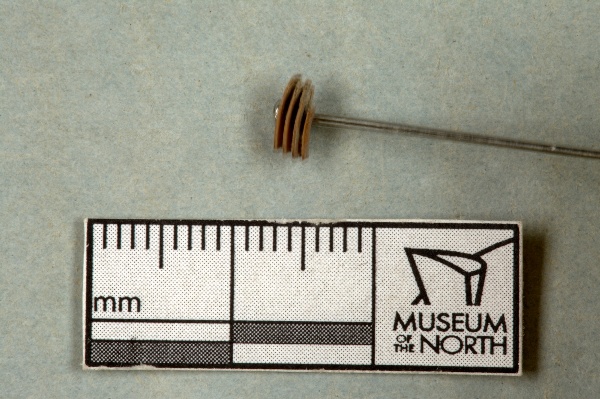
"dwc:identificationRemarks": "small mammal tooth of some kind ; Former nature_of_id: expert.",
"dwc:verbatimCoordinates": "69.7213333333/-155.2675",
"dwc:kingdom": "Animalia",
"dwc:recordedBy": "Collector(s): Bureau of Land Management",
"dwc:georeferencedDate": "2003-06-01 00:00:00",
"dwc:order": "Rodentia",
"dcterms:references": "http://arctos.database.museum/guid/UAM:ES:12165",
"dcterms:accessRights": "http://vertnet.org/resources/norms.html",
"dwc:occurrenceID": "http://arctos.database.museum/guid/UAM:ES:12165?seid=1264128",
"id": "http://arctos.database.museum/guid/UAM:ES:12165?seid=1264128",
"dwc:establishmentMeans": "wild",
"dwc:stateProvince": "Alaska",
"dwc:eventDate": "2003-06-01/2003-08-31",
"dwc:collectionID": "21",
"dwc:institutionCode": "UAM",
"dwc:country": "United States",
"dwc:earliestPeriodOrLowestSystem": "Quaternary",
"dwc:collectionCode": "ES",
"dwc:higherClassification": "Animalia, Chordata, Mammalia,",
"dwc:decimalLatitude": "69.7213333333",
"dwc:georeferenceVerificationStatus": "verified and locked",
"dwc:basisOfRecord": "PreservedSpecimen",
"dwc:preparations": "tooth",
"dwc:identifiedBy": "Paul Matheus",
"dwc:identificationVerificationStatus": "features",
"dwc:georeferenceSources": "USGS Topo Map 1956, 1:63,360 Ipikipuk River (B-3) Quad",
"dwc:previousIdentifications": "[{\"scientific_name\":\"Rodentia\",\"nature_of_id\":\"features\",\"accepted_id_fg\":1,\"made_date\":null,\"short_citation\":null,\"publication_id\":null,\"identification_remarks\":\"small mammal tooth of some kind ; Former nature_of_id: expert.\",\"idby\":\"Paul Matheus\",\"concept_label\":null}]",
"dwc:eventRemarks": "Former verification status: verified by collector.; Mike Kunz, BLM, Arctic Field Office, AK was the PI for this project collection.",
"dwc:organismID": "http://arctos.database.museum/guid/UAM:ES:12165",
"dwc:phylum": "Chordata",
"dwc:locationAccordingTo": "Paul Matheus",
"dwc:locality": "loc. 1, Bad Bear Bluff, Ikpikpuk River Quad, National Petroleum Reserve-Alaska",
"dwc:institutionID": "UAM",
"dwc:associatedMedia": "http://arctos.database.museum/MediaSearch.cfm?collection_object_id=21747308",
"dwc:geodeticDatum": "World Geodetic System 1984",
"dwc:taxonRank": "order",
"dwc:class": "Mammalia",
"dwc:catalogNumber": "UAM:ES:12165",
"dwc:nomenclaturalCode": "ICZN",
"dwc:higherGeography": "United States, Alaska",
"dwc:decimalLongitude": "-155.2675000000",
"dwc:coordinateUncertaintyInMeters": "50",
"dwc:otherCatalogNumbers": "other identifier=T-03-T1-M05",
"dwc:verbatimLocality": "Specimens were collected at various beaches along the Titaluk River, AK.",
"dwc:georeferencedBy": "Paul Matheus",
"dwc:verbatimEventDate": "2003-06-01",
"dwc:eventTime": "2003-06-01/2003-08-31",
"dwc:identificationQualifier": "A",
"dwc:verbatimCoordinateSystem": "decimal degrees",
"dwc:georeferenceProtocol": "BioGeoMancer",
"dcterms:modified": "2022-10-26 08:19:27.024783",
"dwc:scientificName": "Rodentia",
"dwc:footprintWKT": "POLYGON((-155.266208369409 69.7213499689552,-155.266223833858 69.7212622442392,-155.266288340176 69.7211772516011,-155.266399408891 69.7210982572094,-155.266552771319 69.7210282966921,-155.266742533662 69.7209700584917,-155.266961403531 69.7209257805652,-155.267200970176 69.7208971643964,-155.267452027661 69.720885309623,-155.267704928573 69.7208906717883,-155.267949954674 69.720913044839,-155.26817769028 69.7209515690421,-155.268379384015 69.7210047640162,-155.268547285067 69.7210705856094,-155.268674941022 69.7211465044391,-155.268757445837 69.7212296030793,-155.268791628421 69.7213166881614,-155.268776174573 69.7214044130837,-155.268711677572 69.721489406615,-155.268600615471 69.7215684024505,-155.268447255948 69.7216383647426,-155.268257492359 69.7216966047785,-155.268038617282 69.7217408843219,-155.26779904226 69.7217695016427,-155.267547974504 69.7217813569279,-155.267295062992 69.7217759945562,-155.267050027573 69.7217536206125,-155.266822285353 69.7217150949656,-155.266620588713 69.7216618982167,-155.266452688907 69.7215960747879,-155.26632503816 69.7215201543414,-155.266242541723 69.7214370545491,-155.266208369409 69.7213499689552))"
},
"indexTerms": {
"datemodified": "2022-12-07T00:43:16.130603+00:00",
"recordset": "2ec3b31e-c86b-4ce9-b265-77c8c3f9643c",
"dqs": 0.391304347826087,
"stateprovince": "alaska",
"earliestperiodorlowestsystem": "quaternary",
"phylum": "chordata",
"catalognumber": "uam:es:12165",
"startdayofyear": 152,
"taxonrank": "order",
"collector": "collector(s): bureau of land management",
"verbatimlocality": "specimens were collected at various beaches along the titaluk river, ak.",
"uuid": "19a14f97-12ec-470c-93f6-f3d105b204e7",
"countrycode": "usa",
"basisofrecord": "preservedspecimen",
"institutioncode": "uam",
"mediarecords": [
"27a14364-d63f-4008-b6e5-3b5020b5f284"
],
"continent": "north america",
"datecollected": "2003-06-01T20:03:00+00:00",
"etag": "c1581b567e10655eec1853e65fb750afdb91c94e",
"hasMedia": true,
"hasImage": true,
"kingdom": "animalia",
"highertaxon": "animalia, chordata, mammalia,",
"collectionid": "21",
"scientificname": "rodentia",
"locality": "loc. 1, bad bear bluff, ikpikpuk river quad, national petroleum reserve-alaska",
"coordinateuncertainty": 50,
"class": "mammalia",
"occurrenceid": "http://arctos.database.museum/guid/uam:es:12165?seid=1264128",
"institutionid": "uam",
"country": "united states",
"geopoint": {
"lat": 69.7213333333,
"lon": -155.2675
},
"collectioncode": "es",
"eventdate": "2003-06-01/2003-08-31",
"flags": [
"geopoint_datum_error",
"dwc_continent_added",
"idigbio_isocountrycode_added"
],
"verbatimeventdate": "2003-06-01",
"recordids": [
"2ec3b31e-c86b-4ce9-b265-77c8c3f9643c\\urn:occurrence:arctos:uam:es:12165:1264128",
"2ec3b31e-c86b-4ce9-b265-77c8c3f9643c\\http://arctos.database.museum/guid/uam:es:12165?seid=1264128"
],
"order": "rodentia",
"indexData": {
"dwc:identificationRemarks": "small mammal tooth of some kind ; Former nature_of_id: expert.",
"dwc:verbatimCoordinates": "69.7213333333/-155.2675",
"idigbio:dateModified": "2022-12-07T00:43:16.130603",
"dwc:kingdom": "Animalia",
"dwc:recordedBy": "Collector(s): Bureau of Land Management",
"idigbio:uuid": "19a14f97-12ec-470c-93f6-f3d105b204e7",
"dwc:georeferencedDate": "2003-06-01 00:00:00",
"dwc:order": "Rodentia",
"dcterms:references": "http://arctos.database.museum/guid/UAM:ES:12165",
"idigbio:isocountrycode": "usa",
"dcterms:accessRights": "http://vertnet.org/resources/norms.html",
"dwc:locality": "loc. 1, Bad Bear Bluff, Ikpikpuk River Quad, National Petroleum Reserve-Alaska",
"idigbio:recordIds": [
"2ec3b31e-c86b-4ce9-b265-77c8c3f9643c\\urn:occurrence:arctos:uam:es:12165:1264128",
"2ec3b31e-c86b-4ce9-b265-77c8c3f9643c\\http://arctos.database.museum/guid/uam:es:12165?seid=1264128"
],
"dwc:occurrenceID": "http://arctos.database.museum/guid/UAM:ES:12165?seid=1264128",
"id": "http://arctos.database.museum/guid/UAM:ES:12165?seid=1264128",
"dwc:establishmentMeans": "wild",
"idigbio:parent": "2ec3b31e-c86b-4ce9-b265-77c8c3f9643c",
"dwc:stateProvince": "Alaska",
"dwc:eventDate": "2003-06-01/2003-08-31",
"dwc:collectionID": "21",
"dwc:country": "United States",
"dwc:earliestPeriodOrLowestSystem": "Quaternary",
"idigbio:etag": "c1581b567e10655eec1853e65fb750afdb91c94e",
"dwc:collectionCode": "ES",
"dwc:class": "Mammalia",
"dwc:decimalLatitude": "69.7213333333",
"dwc:georeferenceVerificationStatus": "verified and locked",
"dwc:basisOfRecord": "PreservedSpecimen",
"dwc:continent": "north america",
"dwc:preparations": "tooth",
"flag_dwc_continent_added": true,
"dwc:identifiedBy": "Paul Matheus",
"dwc:identificationVerificationStatus": "features",
"dwc:previousIdentifications": "[{\"scientific_name\":\"Rodentia\",\"nature_of_id\":\"features\",\"accepted_id_fg\":1,\"made_date\":null,\"short_citation\":null,\"publication_id\":null,\"identification_remarks\":\"small mammal tooth of some kind ; Former nature_of_id: expert.\",\"idby\":\"Paul Matheus\",\"concept_label\":null}]",
"dwc:geodeticDatum": "World Geodetic System 1984",
"idigbio:siblings": {
"mediarecord": [
"27a14364-d63f-4008-b6e5-3b5020b5f284"
]
},
"dwc:eventRemarks": "Former verification status: verified by collector.; Mike Kunz, BLM, Arctic Field Office, AK was the PI for this project collection.",
"flag_idigbio_isocountrycode_added": true,
"dwc:organismID": "http://arctos.database.museum/guid/UAM:ES:12165",
"dwc:phylum": "Chordata",
"dwc:locationAccordingTo": "Paul Matheus",
"dwc:georeferenceSources": "USGS Topo Map 1956, 1:63,360 Ipikipuk River (B-3) Quad",
"dwc:institutionID": "UAM",
"dwc:associatedMedia": "http://arctos.database.museum/MediaSearch.cfm?collection_object_id=21747308",
"dwc:institutionCode": "UAM",
"dwc:taxonRank": "order",
"dwc:higherClassification": "Animalia, Chordata, Mammalia,",
"dwc:catalogNumber": "UAM:ES:12165",
"dwc:nomenclaturalCode": "ICZN",
"dwc:higherGeography": "United States, Alaska",
"dwc:decimalLongitude": "-155.2675000000",
"dwc:scientificName": "Rodentia",
"dwc:otherCatalogNumbers": "other identifier=T-03-T1-M05",
"dwc:verbatimLocality": "Specimens were collected at various beaches along the Titaluk River, AK.",
"dwc:georeferencedBy": "Paul Matheus",
"dwc:verbatimEventDate": "2003-06-01",
"dwc:eventTime": "2003-06-01/2003-08-31",
"dwc:identificationQualifier": "A",
"dwc:verbatimCoordinateSystem": "decimal degrees",
"dwc:georeferenceProtocol": "BioGeoMancer",
"dcterms:modified": "2022-10-26 08:19:27.024783",
"dwc:coordinateUncertaintyInMeters": "50",
"dwc:footprintWKT": "POLYGON((-155.266208369409 69.7213499689552,-155.266223833858 69.7212622442392,-155.266288340176 69.7211772516011,-155.266399408891 69.7210982572094,-155.266552771319 69.7210282966921,-155.266742533662 69.7209700584917,-155.266961403531 69.7209257805652,-155.267200970176 69.7208971643964,-155.267452027661 69.720885309623,-155.267704928573 69.7208906717883,-155.267949954674 69.720913044839,-155.26817769028 69.7209515690421,-155.268379384015 69.7210047640162,-155.268547285067 69.7210705856094,-155.268674941022 69.7211465044391,-155.268757445837 69.7212296030793,-155.268791628421 69.7213166881614,-155.268776174573 69.7214044130837,-155.268711677572 69.721489406615,-155.268600615471 69.7215684024505,-155.268447255948 69.7216383647426,-155.268257492359 69.7216966047785,-155.268038617282 69.7217408843219,-155.26779904226 69.7217695016427,-155.267547974504 69.7217813569279,-155.267295062992 69.7217759945562,-155.267050027573 69.7217536206125,-155.266822285353 69.7217150949656,-155.266620588713 69.7216618982167,-155.266452688907 69.7215960747879,-155.26632503816 69.7215201543414,-155.266242541723 69.7214370545491,-155.266208369409 69.7213499689552))"
}
},
"attribution": {
"totalCount": 51496
}
}