{
"uuid": "19627028-e770-472b-a07a-1ffd469c950d",
"type": "records",
"etag": "a5f6029dd5da35ea19c099704c7f47b392e32f7d",
"data": {
"dwc:startDayOfYear": "342",
"dwc:specificEpithet": "arizonica",
"dwc:kingdom": "Plantae",
"dwc:recordedBy": "C. Hanson; G. Joseph, M. Larson",
"dwc:order": "Fagales",
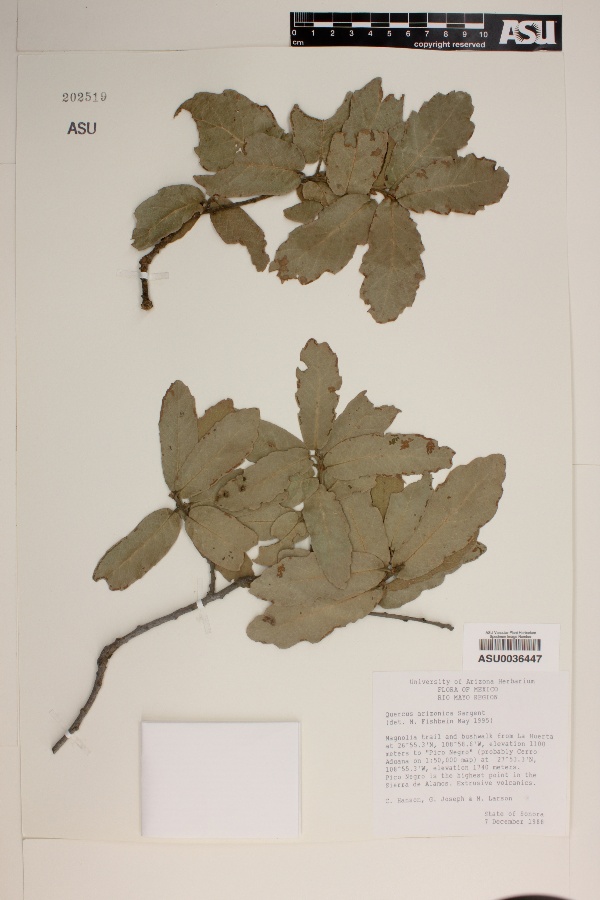
"dwc:habitat": "Extrusive volcanics.",
"dwc:scientificNameAuthorship": "Sarg.",
"dwc:occurrenceID": "1ef743d5-384c-4b4a-8f48-40e718d25659",
"id": "1849211",
"dwc:taxonID": "9855",
"dwc:stateProvince": "Sonora",
"dwc:eventDate": "1988-12-07",
"dwc:collectionID": "a2e32c87-d320-4a01-bafd-a9182ae2e191",
"dwc:country": "Mexico",
"dwc:collectionCode": "Plants",
"symbiota:recordEnteredBy": "Kathy 2010_08_03",
"dwc:decimalLatitude": "26.9217",
"dwc:basisOfRecord": "PreservedSpecimen",
"dwc:genus": "Quercus",
"dwc:family": "Fagaceae",
"dc:rights": "http://creativecommons.org/licenses/by-nc/3.0/",
"dwc:identifiedBy": "M. Fishbein",
"symbiota:recordID": "1ef743d5-384c-4b4a-8f48-40e718d25659",
"dwc:phylum": "Magnoliophyta",
"dcterms:references": "https://swbiodiversity.org/seinet/collections/individual/index.php?occid=1849211",
"dwc:locality": "Magnolia trail and bushwalk from La Huerta to Pico Negro (probably Cerro Aduana on 1:50,000 map). Pico Negro is the highest point in the Sierra de Alamos.",
"dwc:institutionCode": "ASU",
"dwc:taxonRank": "Species",
"dwc:higherClassification": "Plantae|Magnoliophyta|Eudicots|Core Eudicots|Fabids|Rosids|Fagales|Fagaceae|Quercus",
"dwc:catalogNumber": "ASU0036447",
"dwc:month": "12",
"dwc:decimalLongitude": "-108.977",
"dwc:otherCatalogNumbers": "202519",
"dwc:recordNumber": "108",
"dwc:minimumElevationInMeters": "1100",
"dcterms:modified": "2018-03-08 09:13:18",
"dwc:scientificName": "Quercus arizonica",
"dwc:day": "7",
"dwc:year": "1988"
},
"indexTerms": {
"geopoint": {
"lat": 26.9217,
"lon": -108.977
},
"family": "fagaceae",
"recordset": "40250f4d-7aa6-4fcc-ac38-2868fa4846bd",
"dqs": 0.2463768115942029,
"stateprovince": "sonora",
"phylum": "tracheophyta",
"catalognumber": "asu0036447",
"startdayofyear": 342,
"taxonrank": "species",
"specificepithet": "arizonica",
"continent": "north america",
"uuid": "19627028-e770-472b-a07a-1ffd469c950d",
"countrycode": "mex",
"basisofrecord": "preservedspecimen",
"collector": "c. hanson; g. joseph, m. larson",
"institutioncode": "asu",
"mediarecords": [
"cc8a6244-59c3-4e79-abfc-39ce52dfb371"
],
"datemodified": "2022-12-06T21:46:35.594653+00:00",
"datecollected": "1988-12-07T00:00:00+00:00",
"etag": "a5f6029dd5da35ea19c099704c7f47b392e32f7d",
"recordnumber": "108",
"minelevation": 1100,
"hasImage": true,
"kingdom": "plantae",
"highertaxon": "plantae|magnoliophyta|eudicots|core eudicots|fabids|rosids|fagales|fagaceae|quercus",
"collectionid": "a2e32c87-d320-4a01-bafd-a9182ae2e191",
"taxonid": "2877992",
"scientificname": "quercus arizonica",
"indexData": {
"dwc:startDayOfYear": "342",
"dwc:specificEpithet": "arizonica",
"idigbio:dateModified": "2022-12-06T21:46:35.594653",
"dwc:kingdom": "Plantae",
"dwc:recordedBy": "C. Hanson; G. Joseph, M. Larson",
"idigbio:uuid": "19627028-e770-472b-a07a-1ffd469c950d",
"flag_dwc_multimedia_added": true,
"dwc:order": "Fagales",
"dwc:habitat": "Extrusive volcanics.",
"flag_gbif_reference_added": true,
"dwc:scientificNameAuthorship": "sarg.",
"flag_dwc_taxonid_replaced": true,
"dwc:occurrenceID": "1ef743d5-384c-4b4a-8f48-40e718d25659",
"flag_dwc_taxonrank_replaced": true,
"flag_dwc_taxonomicstatus_added": true,
"flag_gbif_genericname_added": true,
"symbiota:recordEnteredBy": "Kathy 2010_08_03",
"dwc:taxonID": "2877992",
"idigbio:parent": "40250f4d-7aa6-4fcc-ac38-2868fa4846bd",
"dwc:stateProvince": "Sonora",
"flag_gbif_taxon_corrected": true,
"dwc:eventDate": "1988-12-07",
"flag_dwc_scientificnameauthorship_replaced": true,
"dwc:collectionID": "a2e32c87-d320-4a01-bafd-a9182ae2e191",
"dwc:country": "Mexico",
"dwc:multimedia": [
{
"dcterms:license": "creative commons attribution 2.0 unported",
"dcterms:references": "http://commons.wikimedia.org/wiki/file:quercus_arizonica_leaves_1.jpg",
"coreid": "2877992",
"dcterms:identifier": "http://upload.wikimedia.org/wikipedia/commons/9/94/quercus_arizonica_leaves_1.jpg",
"dcterms:source": "german wikipedia - species pages",
"dcterms:description": "quercus arizonica leaves. arizona.",
"dcterms:creator": "homeredwardprice",
"dcterms:publisher": "wikimedia commons"
}
],
"idigbio:etag": "a5f6029dd5da35ea19c099704c7f47b392e32f7d",
"dwc:collectionCode": "Plants",
"id": "1849211",
"dwc:decimalLatitude": "26.9217",
"dwc:basisOfRecord": "PreservedSpecimen",
"dwc:taxonomicstatus": "accepted",
"dwc:genus": "Quercus",
"dwc:continent": "north america",
"dwc:family": "Fagaceae",
"dc:rights": "http://creativecommons.org/licenses/by-nc/3.0/",
"dwc:identifiedBy": "M. Fishbein",
"flag_dwc_datasetid_added": true,
"dwc:class": "magnoliopsida",
"idigbio:isocountrycode": "mex",
"idigbio:siblings": {
"mediarecord": [
"cc8a6244-59c3-4e79-abfc-39ce52dfb371"
]
},
"symbiota:recordID": "1ef743d5-384c-4b4a-8f48-40e718d25659",
"flag_idigbio_isocountrycode_added": true,
"gbif:canonicalname": "quercus arizonica",
"dwc:phylum": "tracheophyta",
"dcterms:references": "https://swbiodiversity.org/seinet/collections/individual/index.php?occid=1849211",
"gbif:genericname": "quercus",
"dwc:locality": "Magnolia trail and bushwalk from La Huerta to Pico Negro (probably Cerro Aduana on 1:50,000 map). Pico Negro is the highest point in the Sierra de Alamos.",
"flag_gbif_vernacularname_added": true,
"dwc:institutionCode": "ASU",
"dwc:taxonRank": "species",
"dwc:parentnameusageid": "2877951",
"dwc:higherClassification": "Plantae|Magnoliophyta|Eudicots|Core Eudicots|Fabids|Rosids|Fagales|Fagaceae|Quercus",
"dwc:catalogNumber": "ASU0036447",
"flag_dwc_phylum_replaced": true,
"flag_gbif_canonicalname_added": true,
"dwc:month": "12",
"dwc:decimalLongitude": "-108.977",
"gbif:vernacularname": [
{
"coreid": "2877992",
"dcterms:language": "de",
"dcterms:source": "german wikipedia - species pages",
"dwc:vernacularname": "arizona-eiche"
},
{
"coreid": "2877992",
"dcterms:language": "en",
"dcterms:source": "integrated taxonomic information system (itis)",
"dwc:vernacularname": "arizona white oak"
}
],
"dwc:otherCatalogNumbers": "202519",
"gbif:reference": [
{
"coreid": "2877992",
"dcterms:source": "catalogue of life",
"dcterms:bibliographiccitation": "sarg. (1895) in: gard. & forest 8: 89"
}
],
"flag_dwc_continent_added": true,
"idigbio:recordIds": [
"urn:uuid:1ef743d5-384c-4b4a-8f48-40e718d25659",
"40250f4d-7aa6-4fcc-ac38-2868fa4846bd\\1849211",
"40250f4d-7aa6-4fcc-ac38-2868fa4846bd\\urn:uuid:1ef743d5-384c-4b4a-8f48-40e718d25659",
"40250f4d-7aa6-4fcc-ac38-2868fa4846bd\\1ef743d5-384c-4b4a-8f48-40e718d25659"
],
"dwc:recordNumber": "108",
"dwc:datasetid": "7ddf754f-d193-4cc9-b351-99906754a03b",
"flag_dwc_parentnameusageid_added": true,
"flag_dwc_class_added": true,
"dwc:minimumElevationInMeters": "1100",
"dcterms:modified": "2018-03-08 09:13:18",
"dwc:scientificName": "Quercus arizonica",
"dwc:day": "7",
"dwc:year": "1988"
},
"hasMedia": true,
"class": "magnoliopsida",
"occurrenceid": "1ef743d5-384c-4b4a-8f48-40e718d25659",
"country": "mexico",
"locality": "magnolia trail and bushwalk from la huerta to pico negro (probably cerro aduana on 1:50,000 map). pico negro is the highest point in the sierra de alamos.",
"collectioncode": "plants",
"canonicalname": "quercus arizonica",
"eventdate": "1988-12-07",
"flags": [
"geopoint_datum_missing",
"dwc_multimedia_added",
"gbif_reference_added",
"dwc_taxonid_replaced",
"dwc_taxonrank_replaced",
"dwc_taxonomicstatus_added",
"gbif_genericname_added",
"gbif_taxon_corrected",
"dwc_scientificnameauthorship_replaced",
"dwc_datasetid_added",
"idigbio_isocountrycode_added",
"gbif_vernacularname_added",
"dwc_phylum_replaced",
"gbif_canonicalname_added",
"dwc_continent_added",
"dwc_parentnameusageid_added",
"dwc_class_added"
],
"taxonomicstatus": "accepted",
"recordids": [
"urn:uuid:1ef743d5-384c-4b4a-8f48-40e718d25659",
"40250f4d-7aa6-4fcc-ac38-2868fa4846bd\\1849211",
"40250f4d-7aa6-4fcc-ac38-2868fa4846bd\\urn:uuid:1ef743d5-384c-4b4a-8f48-40e718d25659",
"40250f4d-7aa6-4fcc-ac38-2868fa4846bd\\1ef743d5-384c-4b4a-8f48-40e718d25659"
],
"genus": "quercus",
"order": "fagales",
"datasetid": "7ddf754f-d193-4cc9-b351-99906754a03b"
},
"attribution": {
"totalCount": 283567
}
}