{
"uuid": "14d363da-6057-422a-a4c3-17e5764feefe",
"type": "records",
"etag": "7b90ba596adfcafc9d06dbfb9b2c3958261608b2",
"data": {
"dwc:startDayOfYear": "166",
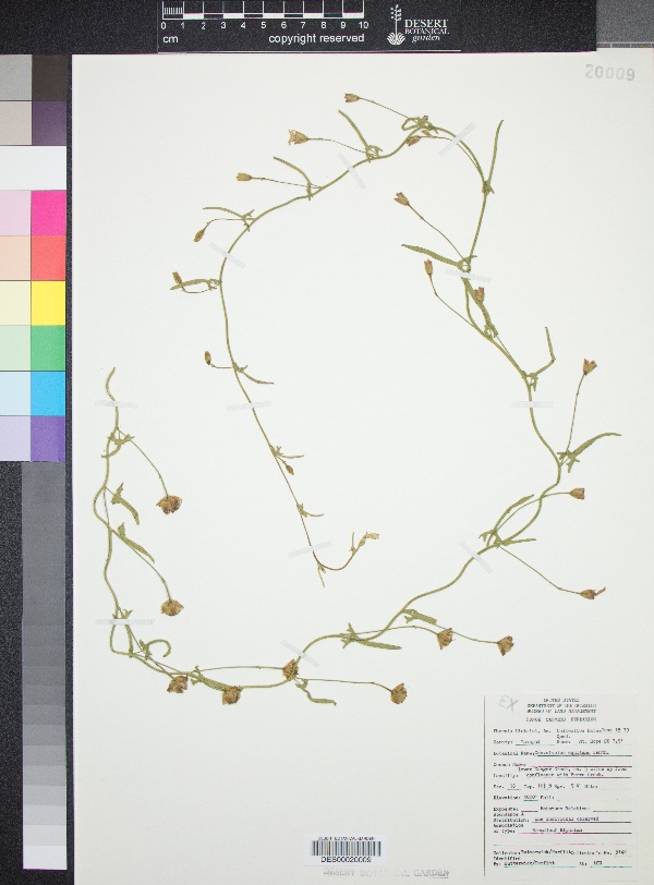
"dwc:specificEpithet": "equitans",
"dwc:county": "Yavapai County",
"dwc:recordedBy": "Butterwick/Parfitt",
"dwc:order": "Solanales",
"dwc:habitat": "Broadleaf Riparian",
"dwc:scientificNameAuthorship": "Benth.",
"dwc:occurrenceID": "88f5c64f-2646-4d88-a54f-e397f4350ecc",
"dwc:verbatimCoordinates": "34d 46m 22.6s N; 113d 7m 58.4s W; TRS: T16N R9W S36",
"dwc:verbatimElevation": "4000ft",
"id": "3091207",
"dwc:taxonID": "3920",
"dwc:stateProvince": "Arizona",
"dwc:eventDate": "1979-06-15",
"dwc:collectionID": "edb9860c-c481-4d19-88cc-224a536ebcd4",
"dwc:country": "USA",
"symbiota:recordEnteredBy": "eleanoreros",
"dwc:kingdom": "Plantae",
"dwc:decimalLatitude": "34.772944",
"dwc:occurrenceRemarks": "One individual observed",
"dwc:basisOfRecord": "PreservedSpecimen",
"dwc:genus": "Convolvulus",
"dwc:family": "Convolvulaceae",
"dc:rights": "http://creativecommons.org/licenses/by-nc/3.0/",
"dwc:identifiedBy": "Butterwick/Parfitt",
"symbiota:recordID": "88f5c64f-2646-4d88-a54f-e397f4350ecc",
"dwc:phylum": "Magnoliophyta",
"dcterms:references": "https://swbiodiversity.org/seinet/collections/individual/index.php?occid=3091207",
"dwc:locality": "Lower Conger Creek, ca 5 mi up from confluence with Burro Creek. Mt. Hope 7.5' Quad",
"dwc:institutionCode": "DES",
"dwc:taxonRank": "Species",
"dwc:reproductiveCondition": "flowers",
"dwc:higherClassification": "Plantae|Magnoliophyta|Eudicots|Core Eudicots|Lamiids|Asterids|Solanales|Convolvulaceae|Convolvulus",
"dwc:catalogNumber": "DES00020009",
"dwc:month": "6",
"dwc:decimalLongitude": "-113.132889",
"dwc:recordNumber": "5142",
"dwc:minimumElevationInMeters": "1219",
"dcterms:modified": "2017-10-17 09:35:53",
"dwc:scientificName": "Convolvulus equitans",
"dwc:day": "15",
"dwc:year": "1979"
},
"indexTerms": {
"geopoint": {
"lat": 34.772944,
"lon": -113.132889
},
"family": "convolvulaceae",
"recordset": "c569e530-7322-40b8-9b66-1e0ed96fefcb",
"dqs": 0.2318840579710145,
"stateprovince": "arizona",
"county": "yavapai county",
"phylum": "tracheophyta",
"catalognumber": "des00020009",
"startdayofyear": 166,
"taxonrank": "species",
"specificepithet": "equitans",
"continent": "north america",
"uuid": "14d363da-6057-422a-a4c3-17e5764feefe",
"countrycode": "usa",
"basisofrecord": "preservedspecimen",
"collector": "butterwick/parfitt",
"institutioncode": "des",
"mediarecords": [
"8c843687-0ae3-441f-8747-9480425e07e9"
],
"datemodified": "2022-12-06T22:03:37.426550+00:00",
"datecollected": "1979-06-15T00:00:00+00:00",
"etag": "7b90ba596adfcafc9d06dbfb9b2c3958261608b2",
"recordnumber": "5142",
"minelevation": 1219,
"hasImage": true,
"kingdom": "plantae",
"highertaxon": "plantae|magnoliophyta|eudicots|core eudicots|lamiids|asterids|solanales|convolvulaceae|convolvulus",
"collectionid": "edb9860c-c481-4d19-88cc-224a536ebcd4",
"taxonid": "2928394",
"scientificname": "convolvulus equitans",
"indexData": {
"dwc:startDayOfYear": "166",
"flag_dwc_country_replaced": true,
"dwc:specificEpithet": "equitans",
"idigbio:dateModified": "2022-12-06T22:03:37.426550",
"dwc:county": "Yavapai County",
"dwc:recordedBy": "Butterwick/Parfitt",
"idigbio:uuid": "14d363da-6057-422a-a4c3-17e5764feefe",
"flag_dwc_multimedia_added": true,
"dwc:order": "Solanales",
"dwc:habitat": "Broadleaf Riparian",
"flag_gbif_reference_added": true,
"dwc:scientificNameAuthorship": "benth.",
"flag_dwc_taxonid_replaced": true,
"dwc:occurrenceID": "88f5c64f-2646-4d88-a54f-e397f4350ecc",
"flag_dwc_taxonrank_replaced": true,
"dwc:verbatimCoordinates": "34d 46m 22.6s N; 113d 7m 58.4s W; TRS: T16N R9W S36",
"dwc:verbatimElevation": "4000ft",
"flag_dwc_taxonomicstatus_added": true,
"flag_gbif_genericname_added": true,
"symbiota:recordEnteredBy": "eleanoreros",
"dwc:taxonID": "2928394",
"idigbio:parent": "c569e530-7322-40b8-9b66-1e0ed96fefcb",
"dwc:stateProvince": "Arizona",
"flag_gbif_taxon_corrected": true,
"dwc:parentnameusageid": "2928386",
"dwc:eventDate": "1979-06-15",
"flag_dwc_scientificnameauthorship_replaced": true,
"dwc:collectionID": "edb9860c-c481-4d19-88cc-224a536ebcd4",
"dwc:country": "united states",
"dwc:multimedia": [
{
"dcterms:license": "creative commons attribution share alike 3.0 unported",
"dcterms:title": "convolvulus arvensis",
"dcterms:references": "http://commons.wikimedia.org/wiki/file:convolvulus_arvensis_bg.jpg",
"coreid": "2928386",
"dcterms:identifier": "http://upload.wikimedia.org/wikipedia/commons/c/cb/convolvulus_arvensis_bg.jpg",
"dcterms:source": "english wikipedia - species pages",
"dcterms:description": "english: convolvulus arvensis Български: Поветица, Конволвулус",
"dcterms:creator": "galia ^",
"dcterms:publisher": "wikimedia commons"
},
{
"dcterms:license": "gnu free documentation license",
"dcterms:title": "ackerwinde (convolvulus arvensis)",
"dcterms:references": "http://commons.wikimedia.org/wiki/file:convolvulus_arvensis_gaulsheim.jpg",
"coreid": "2928386",
"dcterms:identifier": "http://upload.wikimedia.org/wikipedia/commons/f/f7/convolvulus_arvensis_gaulsheim.jpg",
"dcterms:source": "german wikipedia - species pages",
"dcterms:description": "ther field bindweed (convolvulus arvensis) looks like a wonderful decorative plant",
"dcterms:creator": "manfred heyde",
"dcterms:publisher": "wikimedia commons"
}
],
"idigbio:etag": "7b90ba596adfcafc9d06dbfb9b2c3958261608b2",
"id": "3091207",
"dwc:kingdom": "Plantae",
"dwc:decimalLatitude": "34.772944",
"dwc:occurrenceRemarks": "One individual observed",
"dwc:basisOfRecord": "PreservedSpecimen",
"dwc:taxonomicstatus": "accepted",
"dwc:genus": "Convolvulus",
"dwc:continent": "north america",
"dwc:family": "Convolvulaceae",
"dc:rights": "http://creativecommons.org/licenses/by-nc/3.0/",
"dwc:identifiedBy": "Butterwick/Parfitt",
"flag_dwc_datasetid_added": true,
"dwc:class": "magnoliopsida",
"idigbio:isocountrycode": "usa",
"idigbio:siblings": {
"mediarecord": [
"8c843687-0ae3-441f-8747-9480425e07e9"
]
},
"symbiota:recordID": "88f5c64f-2646-4d88-a54f-e397f4350ecc",
"flag_idigbio_isocountrycode_added": true,
"gbif:canonicalname": "convolvulus equitans",
"dwc:phylum": "tracheophyta",
"dcterms:references": "https://swbiodiversity.org/seinet/collections/individual/index.php?occid=3091207",
"gbif:genericname": "convolvulus",
"dwc:locality": "Lower Conger Creek, ca 5 mi up from confluence with Burro Creek. Mt. Hope 7.5' Quad",
"flag_gbif_vernacularname_added": true,
"dwc:institutionCode": "DES",
"dwc:taxonRank": "species",
"dwc:reproductiveCondition": "flowers",
"dwc:higherClassification": "Plantae|Magnoliophyta|Eudicots|Core Eudicots|Lamiids|Asterids|Solanales|Convolvulaceae|Convolvulus",
"dwc:catalogNumber": "DES00020009",
"flag_dwc_phylum_replaced": true,
"flag_gbif_canonicalname_added": true,
"dwc:month": "6",
"dwc:decimalLongitude": "-113.132889",
"gbif:vernacularname": [
{
"coreid": "2928394",
"dcterms:source": "integrated taxonomic information system (itis)",
"dwc:vernacularname": "gray bindweed"
},
{
"coreid": "2928394",
"dcterms:source": "catalogue of life",
"dwc:vernacularname": "texas bindweed"
},
{
"coreid": "2928394",
"dcterms:source": "integrated taxonomic information system (itis)",
"dwc:vernacularname": "texas bindweed"
}
],
"gbif:reference": [
{
"coreid": "2928394",
"dcterms:source": "catalogue of life",
"dcterms:bibliographiccitation": "benth. (1843) in: pl. hartw. 16"
}
],
"flag_dwc_continent_added": true,
"idigbio:recordIds": [
"urn:uuid:88f5c64f-2646-4d88-a54f-e397f4350ecc",
"c569e530-7322-40b8-9b66-1e0ed96fefcb\\urn:uuid:88f5c64f-2646-4d88-a54f-e397f4350ecc",
"c569e530-7322-40b8-9b66-1e0ed96fefcb\\3091207",
"c569e530-7322-40b8-9b66-1e0ed96fefcb\\88f5c64f-2646-4d88-a54f-e397f4350ecc"
],
"dwc:recordNumber": "5142",
"dwc:datasetid": "7ddf754f-d193-4cc9-b351-99906754a03b",
"flag_dwc_parentnameusageid_added": true,
"flag_dwc_class_added": true,
"dwc:minimumElevationInMeters": "1219",
"dcterms:modified": "2017-10-17 09:35:53",
"dwc:scientificName": "Convolvulus equitans",
"dwc:day": "15",
"dwc:year": "1979"
},
"hasMedia": true,
"class": "magnoliopsida",
"occurrenceid": "88f5c64f-2646-4d88-a54f-e397f4350ecc",
"country": "united states",
"locality": "lower conger creek, ca 5 mi up from confluence with burro creek. mt. hope 7.5' quad",
"canonicalname": "convolvulus equitans",
"eventdate": "1979-06-15",
"flags": [
"geopoint_datum_missing",
"dwc_country_replaced",
"dwc_multimedia_added",
"gbif_reference_added",
"dwc_taxonid_replaced",
"dwc_taxonrank_replaced",
"dwc_taxonomicstatus_added",
"gbif_genericname_added",
"gbif_taxon_corrected",
"dwc_scientificnameauthorship_replaced",
"dwc_datasetid_added",
"idigbio_isocountrycode_added",
"gbif_vernacularname_added",
"dwc_phylum_replaced",
"gbif_canonicalname_added",
"dwc_continent_added",
"dwc_parentnameusageid_added",
"dwc_class_added"
],
"taxonomicstatus": "accepted",
"recordids": [
"urn:uuid:88f5c64f-2646-4d88-a54f-e397f4350ecc",
"c569e530-7322-40b8-9b66-1e0ed96fefcb\\urn:uuid:88f5c64f-2646-4d88-a54f-e397f4350ecc",
"c569e530-7322-40b8-9b66-1e0ed96fefcb\\3091207",
"c569e530-7322-40b8-9b66-1e0ed96fefcb\\88f5c64f-2646-4d88-a54f-e397f4350ecc"
],
"genus": "convolvulus",
"order": "solanales",
"datasetid": "7ddf754f-d193-4cc9-b351-99906754a03b"
},
"attribution": {
"totalCount": 94693
}
}