{
"uuid": "0bd6c860-dd2b-4904-90ba-5b76a9a2ee83",
"type": "records",
"etag": "2fefd08ae3b6e2e16b0c5a8b0dc003770814e720",
"data": {
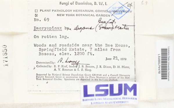
"dwc:startDayOfYear": "172",
"dwc:recordedBy": "Richard P. Korf; J. B. Benson; J. R. Dixon; D. H. Pfister; A. Y. Rossman; L. E. Skog",
"dwc:georeferenceSources": "2016-04-06; Google Maps",
"dcterms:references": "https://mycoportal.org/portal/collections/individual/index.php?occid=1956751",
"dwc:scientificNameAuthorship": "(Berk & Curt.) Martin",
"dwc:occurrenceID": "b2a29d86-271b-4e44-a8bc-1c66e5f136b3",
"dwc:verbatimElevation": "1200 ft",
"id": "1956751",
"dwc:eventDate": "1970-06-21",
"dwc:collectionID": "8f3d5b53-acea-4e2a-89de-0162fd1ffadb",
"dwc:institutionCode": "LSUM",
"dwc:country": "Dominica",
"idigbio:recordId": "urn:uuid:b2a29d86-271b-4e44-a8bc-1c66e5f136b3",
"dwc:collectionCode": "Fungi",
"symbiota:recordEnteredBy": "jaydongovender",
"dwc:decimalLatitude": "15.305659",
"dwc:basisOfRecord": "PreservedSpecimen",
"dwc:georeferenceRemarks": "lat/long = center of Roseau; uncertainty = extent of Roseau + 7 mi. (direction from Roseau not given); Springfield Plantation/ Estate not found",
"dc:rights": "http://creativecommons.org/publicdomain/zero/1.0/",
"dwc:identifiedBy": "Bernard Lowy",
"dwc:habitat": "Woods; On rotten log",
"dwc:locality": "Woods and roadside near the Bee House, Springfield Estate, 7 miles from Roseau, elev. 1200 ft.",
"dwc:geodeticDatum": "WGS84",
"dwc:catalogNumber": "LSU00174470",
"dwc:month": "6",
"dwc:decimalLongitude": "-61.376128",
"dwc:coordinateUncertaintyInMeters": "13635",
"dwc:otherCatalogNumbers": "171850",
"dwc:georeferencedBy": "cmozzicato (2016-04-06 14:47:06)",
"dwc:recordNumber": "69",
"dwc:minimumElevationInMeters": "366",
"dcterms:modified": "2017-04-19 14:31:41",
"dwc:scientificName": "Dacryopinax degans",
"dwc:day": "21",
"dwc:year": "1970"
},
"indexTerms": {
"recordset": "7ad07cff-f782-4ddf-b780-3a757cdb77e0",
"dqs": 0.2753623188405797,
"catalognumber": "lsu00174470",
"startdayofyear": 172,
"collector": "richard p. korf; j. b. benson; j. r. dixon; d. h. pfister; a. y. rossman; l. e. skog",
"continent": "north america",
"uuid": "0bd6c860-dd2b-4904-90ba-5b76a9a2ee83",
"countrycode": "dma",
"basisofrecord": "preservedspecimen",
"institutioncode": "lsum",
"mediarecords": [
"944ef8c4-7d29-4728-8d0c-0ac05f0ee993"
],
"datecollected": "1970-06-21T00:00:00+00:00",
"etag": "2fefd08ae3b6e2e16b0c5a8b0dc003770814e720",
"recordnumber": "69",
"minelevation": 366,
"hasImage": true,
"collectionid": "8f3d5b53-acea-4e2a-89de-0162fd1ffadb",
"scientificname": "dacryopinax degans",
"locality": "woods and roadside near the bee house, springfield estate, 7 miles from roseau, elev. 1200 ft.",
"hasMedia": true,
"coordinateuncertainty": 13635,
"datemodified": "2021-04-19T22:39:30.902311+00:00",
"occurrenceid": "b2a29d86-271b-4e44-a8bc-1c66e5f136b3",
"country": "dominica",
"geopoint": {
"lat": 15.305659,
"lon": -61.376128
},
"collectioncode": "fungi",
"flags": [
"idigbio_isocountrycode_added",
"dwc_continent_added"
],
"recordids": [
"urn:uuid:b2a29d86-271b-4e44-a8bc-1c66e5f136b3",
"7ad07cff-f782-4ddf-b780-3a757cdb77e0\\1956751",
"7ad07cff-f782-4ddf-b780-3a757cdb77e0\\b2a29d86-271b-4e44-a8bc-1c66e5f136b3"
],
"eventdate": "1970-06-21",
"indexData": {
"dwc:startDayOfYear": "172",
"dwc:geodeticDatum": "WGS84",
"dwc:recordedBy": "Richard P. Korf; J. B. Benson; J. R. Dixon; D. H. Pfister; A. Y. Rossman; L. E. Skog",
"idigbio:uuid": "0bd6c860-dd2b-4904-90ba-5b76a9a2ee83",
"dwc:georeferenceSources": "2016-04-06; Google Maps",
"dwc:habitat": "Woods; On rotten log",
"dwc:scientificNameAuthorship": "(Berk & Curt.) Martin",
"idigbio:recordIds": [
"urn:uuid:b2a29d86-271b-4e44-a8bc-1c66e5f136b3",
"7ad07cff-f782-4ddf-b780-3a757cdb77e0\\1956751",
"7ad07cff-f782-4ddf-b780-3a757cdb77e0\\b2a29d86-271b-4e44-a8bc-1c66e5f136b3"
],
"dwc:occurrenceID": "b2a29d86-271b-4e44-a8bc-1c66e5f136b3",
"dwc:verbatimElevation": "1200 ft",
"symbiota:recordEnteredBy": "jaydongovender",
"idigbio:parent": "7ad07cff-f782-4ddf-b780-3a757cdb77e0",
"dwc:eventDate": "1970-06-21",
"dwc:collectionID": "8f3d5b53-acea-4e2a-89de-0162fd1ffadb",
"dwc:country": "Dominica",
"idigbio:recordId": "urn:uuid:b2a29d86-271b-4e44-a8bc-1c66e5f136b3",
"idigbio:etag": "2fefd08ae3b6e2e16b0c5a8b0dc003770814e720",
"dwc:collectionCode": "Fungi",
"id": "1956751",
"dwc:decimalLatitude": "15.305659",
"dwc:basisOfRecord": "PreservedSpecimen",
"dwc:georeferenceRemarks": "lat/long = center of Roseau; uncertainty = extent of Roseau + 7 mi. (direction from Roseau not given); Springfield Plantation/ Estate not found",
"dwc:continent": "north america",
"dc:rights": "http://creativecommons.org/publicdomain/zero/1.0/",
"dwc:identifiedBy": "Bernard Lowy",
"idigbio:siblings": {
"mediarecord": [
"944ef8c4-7d29-4728-8d0c-0ac05f0ee993"
]
},
"flag_idigbio_isocountrycode_added": true,
"dcterms:references": "https://mycoportal.org/portal/collections/individual/index.php?occid=1956751",
"idigbio:dateModified": "2021-04-19T22:39:30.902311",
"dwc:locality": "Woods and roadside near the Bee House, Springfield Estate, 7 miles from Roseau, elev. 1200 ft.",
"dwc:institutionCode": "LSUM",
"dwc:catalogNumber": "LSU00174470",
"dwc:month": "6",
"dwc:decimalLongitude": "-61.376128",
"dwc:scientificName": "Dacryopinax degans",
"dwc:otherCatalogNumbers": "171850",
"dwc:georeferencedBy": "cmozzicato (2016-04-06 14:47:06)",
"flag_dwc_continent_added": true,
"dwc:recordNumber": "69",
"idigbio:isocountrycode": "dma",
"dwc:minimumElevationInMeters": "366",
"dcterms:modified": "2017-04-19 14:31:41",
"dwc:coordinateUncertaintyInMeters": "13635",
"dwc:day": "21",
"dwc:year": "1970"
}
},
"attribution": {
"totalCount": 18363
}
}